
About four years ago, Edita and I thought that it might be a nice way to pass the time if we started ticking off the highest point in each of the UK’s counties (a list known as the ‘county tops’). This has led to some enthralling visits to roadsides, electricity pylons, sewage farms and junkyards. But it has also led to some quite enjoyable hikes up obscure hills we wouldn’t otherwise have visited.
A couple of weeks ago, we finished bagging all thirteen of the historic county tops in Wales. The historic counties are those that existed until the administrative boundaries were changed in 1974. You can see all of the Welsh ones in the map below.

Unlike those in England, all of the Welsh county tops are proper hills. Our journey provided plenty of variety, from woodland trails to coastal paths, peat bogs, escarpment edges, and some decent hill walks with wide views and airy ridges. To complete them, we took a tour of Welsh mountain ranges, from the well known like the Snowdon massif, Brecon Beacons and Black Mountains, to more obscure ones such as the Clwydian Hills, the Berwyns, Arans, Cambrians, Mynydd Du, Rhigos and Preseli Hills.
I thought you might appreciate a list with route maps, so here it is. If you click on some of the links, you can even read my hilarious trip reports.
1: Caernarfonshire
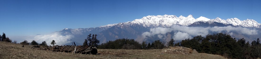
Snowdon / Yr Wyddfa (1,085m)

Caernarfonshire is the Welsh county in the extreme north-west of the mainland that includes the Lleyn Peninsula and the northern part of Snowdonia. It therefore contains the highest peaks in Wales.
Snowdon, also known as Yr Wyddfa, is of course one of Britain’s best-known mountains. Not only is it the highest peak in Caernarfonshire, but also the highest peak in Wales and higher than any mountain in England. Its rich history caused me to use it as the symbolic starting point for my journey to the highest point in the world, chronicled in my book Seven Steps from Snowdon to Everest.
Snowdon is rightly famous and unsurprisingly popular. So many people climb it now that on most weekends, controversially, if you want to have your photo taken atop its summit platform then you will find yourself joining the back of a long queue.
It’s a sprawling massif with many varied routes up, including the Watkin Path, the Snowdon Ranger Path, the gentler Llanberis Path, and the classic Snowdon Horseshoe that follows knife-edge ridges around the crest of a dramatic lake-filled combe.
The Snowdon Horseshoe
Total distance: 10.99km. Total ascent/descent: 1,023mm.
View route map and download GPX
2: Merionethshire
Aran Fawddwy (905m)

Immediately south of Caernarfonshire, Merionethshire hugs the Irish Sea coast south of the Lleyn Peninsula, but stretches far inland, across the peaks of southern Snowdonia to touch the eastern fringes of the Berwyn range.
The Aran Hills form a north-south ridge extending 14km from the shores of Bala Lake to the sleepy village of Dinas Mawddwy, nestling between hills at a confluence of the River Dovey. The central part of the ridge remains above 800m for more than 2km and reaches up to 905m on Aran Fawddwy, the highest mountain in southern Snowdonia.
Less well known than its slightly lower neighbour Cadair Idris, Aran Fawddwy and its sister peak Aran Benllyn give good views of southern Snowdonia’s varied mountain ranges. I recently returned on a day hike from the south, having slept on one of the Arans’ summits during a backpacking trip a few years ago.
Aran Fawddwy and Aran Benllyn
Total distance: 16.93km. Total ascent/descent: 1,070m.
View route map and download GPX
3: Brecknockshire
Pen y Fan (886m)

Brecknockshire spans the mountainous border region of south-east Wales that includes the Brecon Beacons (now known as Bannau Brycheiniog) and the Black Mountains.
Its highest point, Pen y Fan, is arguably Wales’s second most famous peak after Snowdon. The twin flat tops of Pen y Fan and its sister peak Corn Du rise like chimneys above the surrounding landscape, and are unmistakable. Strangely, they seem to look the same whatever direction you look from.
Pen y Fan is the high point on an undulating red sandstone escarpment, which gives way steeply on its northern flanks, and more gently to the south. It’s a mere 45 minutes to the top from the car park at Storey Arms on the west side, but it’s more fun to go up from the north and follow the escarpment edge over many tops, or follow a horseshoe from the Neuadd Reservoir to the south.
Last year I had an enjoyable walk over the quiet outlying peak of Fan Frynych before joining the crowds on the tourist trail, and this is the route described below.
Pen y Fan via Fan Frynych
Total distance: 23.05km. Total ascent/descent: 1,007m.
View route map and download GPX
4 and 5: Denbighshire and Montgomeryshire
Cadair Berwyn (832m) and Moel Sych (826m)

These two peaks are included together because they are only a stone’s throw away from each other on the same rolling ridge. If you’re going to do one then you might as well do them both.
The three historic counties of Merionethshire, Denbighshire and Montgomeryshire converge in the Berwyn Hills of north/central Wales. The borders of all three counties (Merionethshire on the west side, and Denbighshire/Montgomeryshire on the east side) follow the main ridge.
The Berwyn Hills are an isolated area of rolling, boggy moorland far to the east of the main Snowdonia peaks, composed chiefly of a single short ridge.
Edita and I climbed the peaks on one of those annoying days where a promising weather forecast fails to deliver. After driving up from the Cotswolds hoping for a great day out, we found ourselves walking through a soupy mist with views as far as the end of my nose. We will have to go back there again.
The highest point on the ridge is actually Cadair Berwyn’s south top, about 200m south of the point where the Ordnance Survey erected their trig point and marked the summit prominently on the map. Although we must have walked straight over it, I didn’t realise its significance until later. Our summit photos were therefore taken from the lower summit.
Cadair Berwyn and Moel Sych
Total distance: 22.61km. Total ascent/descent: 936m.
View route map and download GPX
6: Carmarthenshire
Fan Foel (781m)

Confusingly, the highland region of South Wales covered by the Bannau Brycheiniog (or Brecon Beacons) National Park is actually composed of three separate mountain ranges. From west to east these are the Mynydd Du (which is Welsh for ‘Black Mountains’), the Bannau Brycheiniog itself, and the Black Mountains (which is English for ‘Mynydd Du’).
The historic county of Carmarthenshire stretches from the south coast into the western part of these mountains. Its highest point lies within the Mynydd Du range, though perhaps just as confusingly, the highest point in Carmarthenshire is not the highest point in the Mynydd Du. The highest point in Carmarthenshire, Fan Foel, lies on the border of Carmarthenshire and Brecknockshire. The highest point in the Mynydd Du is a peak a few metres to the south called – you’re going to love this – Fan Brycheiniog (which you might expect to find in the Bannau Brycheiniog range, but can’t).
As young people say, whatever. Like Bannau Brycheiniog, the Mynydd Du is a sandstone escarpment which falls away suddenly after rising gradually through grassy peat bog. I first encountered these peaks on a quiet backpacking adventure many years ago. The route described below, however, is an easier day hike that follows the base of the escarpment past lakes, before rising up to the top of the escarpment to come back along it, crossing all its peaks in the process.
Beware of taking a shortcut where the route turns abruptly south, or you will miss Fan Foel, the highest point in Carmarthenshire. This means you will have to go back and do it again.
The Mynydd Du escarpment
Total distance: 22.78km. Total ascent/descent: 991m.
View route map and download GPX
7: Cardiganshire
Plynlimon (752m)

Cardiganshire spans the coastline of central Wales, but on its eastern side it rises to meet the spine of the Cambrian Mountains, which stretch for nearly 80km from north to south through central Wales.
The Cambrians lack the steep, rocky summits of Snowdonia and dramatic escarpments of the Bannau Brycheiniog, but what they lack in drama they make up for in remoteness and solitude, with long views and wild grasslands stretching to the far horizon.
Their highest peak, 752m Plynlimon, is a complex mountain of multiple rolling summits connected by broad ridges. It is the source of Britain’s longest river, the Severn, its fourth longest, the River Wye, and a third river, the Rheidol, which flows west into the Irish Sea at Aberystwyth.
I whipped the route below from Richard Gilbert’s classic walking guide 200 Challenging Walks in Britain and Ireland, so beware: it’s a biggie, crossing all of Plynlimon’s highest summits.
The five tops of Plynlimon
Total distance: 30.57km. Total ascent/descent: 970m.
View route map and download GPX
8: Monmouthshire
Chwarel y Fan (680m)

Monmouthshire is the county in the far south-east of Wales, bordering the River Wye and the English counties of Herefordshire and Gloucestershire. It is the most accessible one for me, and I can reach it in around an hour from my home in the Cotswolds.
Parts of Monmouthshire touch the Black Mountains and it’s in this range that its county top can be found. But just like the Mynydd Du range on the other side of the Brecon Beacons (see Carmarthenshire), the highest point in the Black Mountains (Waun Fach) lies in neighbouring Brecknockshire, and not Monmouthshire.
The first time I climbed the highest point in Monmouthshire, Chwarel y Fan, I was unaware of its significance. I wasn’t even aware that I was climbing a mountain. I camped down beside the Grwyne Fawr Reservoir, then ascended to traverse the full length of the ridge above. Chwarel y Fan was the highest point on the ridge. I must have crossed it, but it’s not much of a summit.
It does, however, enjoy splendid views of the famous Vale of Eywas. I returned to Chwarel y Fan with Edita a couple of years ago. The route below is the one we took that day, starting from Llanthony Priory in the Vale of Eywas.
Chwarel y Fan
Total distance: 14.06km. Total ascent/descent: 588m.
View route map and download
9: Radnorshire
Great Rhos (660m)

The old county of Radnorshire lies in a sparsely populated area bordering England, known as the ‘Welsh Marches’ (‘march’ is a mediaeval term for borderland). On the eastern extremity of Radnorshire is an upland area known less appropriately as the Radnor Forest. While there are some pockets of woodland, the area is principally peat bog.
Somewhere in the middle of a giant boggy plateau is a trig pillar that marks the summit of Great Rhos, the highest point in Radnorshire. To reach it, it’s necessary to tiptoe alongside a wire fence overlooking a military firing range, keeping your eye out for unexploded ordnance.
If this doesn’t sound very appealing, it’s worth noting that there is plenty of good walking nearby. There is also one of my favourite Welsh pubs: the Harp Inn, Old Radnor, which boasts a magnificent garden with a view. We climbed Great Rhos the day after climbing nearby Hergest Ridge, the hill which inspired Mike Oldfield’s seminal prog rock classic of the same name.
Great Rhos
Total distance: 12.34km. Total ascent/descent: 506m.
View route map and download
10: Glamorgan
Craig y Llyn (600m)

If Radnorshire is the most sparsely populated Welsh county, Glamorgan is comfortably the most populous. It is also the only one that supports a first-class cricket team, who won the county championship as recently as 1997. Sited on the south coast, Glamorgan contains the two big cities of Cardiff and Swansea, and the dozens of former mining communities known as the South Wales Valleys (or simply The Valleys).
The Rhigos Hills form an escarpment at the northern end of these parallel rifts. The land is criss-crossed by forestry tracks and home to many wind farms. The trig pillar marking the highest point in Glamorgan is currently tucked away in forest beside one of these tracks (‘currently’ because the forest will be cut down for timber some day).
The escarpment with the high point is known as Craig y Llyn, though this name (translated as ‘Cliff of the Lake’) must originally have referred to the cliffs beneath it. Thrill seekers may be interested to know that Craig y Llyn is also home to the Phoenix, advertised as the ‘world’s fastest seated zip line’ (though sitting down on a zip wire is definitely cheating).
Craig y Llyn
Total distance: 10.27km. Total ascent/descent: 322m.
View route map and download
11: Flintshire
Moel Famau (555m)

Flintshire is the county in the far north-east of Wales, bordering the north coast, Dee Estuary and Cheshire. The Clwydian Hills cut through the county from north to south. Composed of deep sea sediments such as mudstone and siltstone, they form a rolling line of upland with views of both the industrial heartland of Cheshire and Merseyside to the east, and the high peaks of Snowdonia to the west.
The distinctive summit of Moel Famau is topped by a squat, roofless tower known as Jubilee Tower, built in 1810 to commemorate the golden jubilee of George III, but partially destroyed by a storm in 1862.
The long-distance trail of Offa’s Dyke Path crosses right over the top. The area to the south has been pleasantly landscaped with a network of forest trails, and two broad tracks lead all the way to the summit. A nice easy one, but very enjoyable.
Moel Famau
Total distance: 6.32km. Total ascent/descent: 289m.
View route map and download
12: Pembrokeshire
Foel Cwmcerwyn (536m)

Pembrokeshire, the sticking out bit in the south-west corner of Wales, is better known for its dramatic coastline of towering cliffs, than for its mountains. I learned in school that the Preseli Hills close to the western tip, have the claim to fame of being the source of the bluestones that were transported to Stonehenge by druids around 5,000 years ago. We were taught that the stones were rolled 150 miles on logs, but having been brought up on Asterix books, I wondered why the druids didn’t just use magic potion.
The high point, Foel Cwmcerwyn, is a windswept grassy top rising above the mines which have now been left to become forested. On a clear day you may be able to see the Irish Sea in three directions, though when I was there we could only manage to spy the sea on the north side. A visit to this region is incomplete without a coastal walk the following day.
The route here starts from a campsite to the south where we stayed. Another good starting point is the pink pub in the village of Rosebush, that looks like it belongs more properly in Mar-a-Lago than South Wales. The pub looks much better on the inside though, especially when you view it through a glass of beer.
Foel Cwmcerwyn, Foel Feddau and Foel Eryr
Total distance: 6.32km. Total ascent/descent: 289m.
View route map and download
13: Anglesey
Holyhead Mountain (220m)

The least mountainous peak on this list is of course the only one with the word ‘mountain’ in its name. But don’t let that put you off.
Many people who visit the island (and county) of Anglesey in the north-west corner of Wales, only pass through on their way to Holyhead to catch the Dublin ferry. By the time they’ve had their first few pints of Guinness, they’ve forgotten what the place looks like.
Holyhead Mountain, which rises above the town of Holyhead on the outlying Holy Island, is comfortably the smallest hill on this list. But it’s a good one, accessible via a picturesque coast path above the sea cliffs of Gogarth Bay, a legendary British rock climbing venue (I would recommend taking the footpath, however).
If you visit on a weekend then the haunted South Stack Lighthouse is well worth a visit (mountaineers like yourselves won’t mind descending the 400 steps to reach its rocky outcrop then climbing back up again). The area is known for its seabird colonies. Our tour guide on the lighthouse said that people sometimes ask him if they will see penguins. Sadly the nearest ones are in Cape Town.
Holyhead Mountain from Elin’s Tower
Total distance: 6.32km. Total ascent/descent: 289m.
View route map and download


