
Much has been written about Joe Brown, the great alpinist and rock climber who died earlier this year. In some ways his life was a conventional rags-to-riches story: a working-class lad from Manchester who by means of his exceptional talent went on to own a chain of successful climbing shops and become one of the most celebrated mountaineers in the world.
In today’s post, I’m going to talk about an episode where he tried distinctly unconventional means to achieve his fortune — when he followed an ancient treasure map into the Andes in search of Inca gold. It sounds like a work of fiction from the pen of Robert Louis Stevenson, but this is a true story.

Joe Brown was the youngest of seven children from a poor area of Manchester. His father died when he was still a baby, and the family was supported by his mother’s cleaning and laundry work. Joe left school at 14 to work as a builder. He began exploring the peaks of the Pennines to the north of his home, and discovered his prodigious talent for rock climbing.
In the 1950s he formed a partnership with another gritty northerner, Don Whillans. They made first ascents of many unclimbed routes in North Wales, and moved on to the Alps, where Joe’s achievements led to an invitation to join the 1955 British expedition to Kangchenjunga. Still only 24, Joe proved to be the star of that expedition. He made the first ascent along with George Band, and was catapulted into Himalayan superstardom.
But what on earth has any of this got to do with Inca gold? That part of the story began in the late 1970s. By then Joe was something of a TV star, a veteran of many expeditions to the world’s greater ranges, and owner of several climbing shops. His friend, the equally distinguished Scottish mountaineer Hamish MacInnes, chanced to read the memoirs of a Scottish naturalist called Richard Spruce, who spent several years of his life in the Andes collecting plant specimens for Kew Gardens.
The last chapter of Spruce’s book was called ‘Hidden Treasure’ and contained a reproduction of an ancient treasure map. The story concerned Atahualpa, the last Inca emperor, who was imprisoned and killed by the Spanish conquistador Francisco Pizarro in 1533. One of Atahualpa’s generals, the Inca warrior Rumiñahui was in the process of transporting 750 tons of gold from Quito to Cajamarca in Peru, where Atahualpa was imprisoned, to pay the emperor’s ransom. When he learned of Atahualpa’s death, Rumiñahui turned east into the Llanganates Mountains, a bleak region of remote and misty grasslands, and hid all the treasure in a cave. Rumiñahui was captured and tortured by the Spanish, but he never revealed the location of Atahualpa’s treasure.

Two hundred years later, a Spanish mercenary called Valverde married a native girl from the town of Latacunga, a short distance from the great Ecuadorian volcano Cotopaxi. As a wedding present, the girl’s father was said to have showed Valverde the place where the treasure was hidden. Valverde found the cave and became a wealthy man. On his deathbed he bequeathed a map showing the location of the treasure to the King of Spain.
The king sent an expedition to follow Valverde’s map, but it was unsuccessful. It failed to find the treasure and a friar who accompanied the expedition drowned in a swamp. Countless expeditions have followed. Whether the treasure ever existed is a moot point. If anyone has ever found it, they’ve never revealed its whereabouts. It’s likely that any treasure there may have been has now been looted, but this doesn’t deter would-be fortune-seekers. The expeditions continue to this day — when Edita and I were out in the Llanganates last year, our guides told us of a Swiss party who had been out looking for treasure the previous year.
Hamish MacInnes was also intrigued. He called his friend Joe Brown and told him the story.
‘Sounds interesting, when do we go?’ said Joe.
The story of their three expeditions in 1979, 1980 and 1981 is described at length in Hamish MacInnes’ book Beyond the Ranges. The book’s laddish humour feels a little dated and sometimes cruel, while the disparaging manner by which Hamish describes the local Ecuadorians (whom he refers to throughout as ‘Indians’) can also be grating, but the 100 pages or so devoted to the Llanganates is a rarity in mountaineering literature and well worth a read.

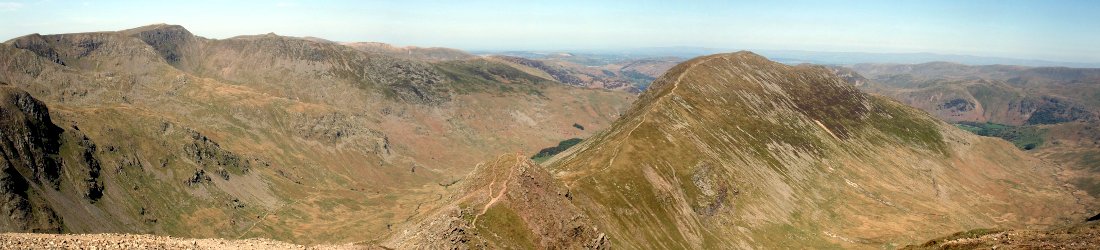
The Llanganates Mountains (pronounced yan-gan-a-tees) are remote and rarely visited. Unusually for the mountains of Ecuador, they are not volcanic. They lie at around 3,500 to 4,500m altitude, immediately south of the volcanoes of Cotopaxi and Antisana, on the eastern edge of the Avenue of the Volcanoes, where the high plateau of Ecuador’s central highlands falls away to the Amazon jungle. It’s classic páramo terrain: cold, wet, bleak grasslands, where the clouds accumulate and blanket the landscape in a cold mist.
The highest peak in the Llanganates is Cerro Hermoso (4,576m), a multi-summited crown of rock that rises a little way north of the resort town of Baños, which nestles at the base of a deep gorge marking the southern boundary of the Llanganates. My own experience of this region was brief and laughable. Last year Edita and I tried to complete the 5-day round trip across the Llanganates to climb Cerro Hermoso, but I was ill within minutes of leaving the trailhead. I staggered to our first camp beside a small lake in the heart of the Llanganates, but was too sick to go on. We aborted our trip and headed back to civilisation the following day.
Joe and Hamish’s first expedition with another famous friend, the American climber and equipment manufacturer Yvon Chouinard, turned out to be something of a reconnaissance. It was a shoestring affair. Unimpressed by the local guides and porters offering their services in the town of San Jose, beneath the western side of the range, the three men decided to set out on their own, carrying all their own gear.
‘We had two air survey maps which covered half of the Llanganati and I had a compass — what more could good Boy Scouts wish for?’ MacInnes said.
Unusually, the weather was sunny, and locals told them later that it was the best weather for years. They decided to strike towards Cerro Hermoso and then head north. Hamish experienced sunstroke on the first day, and had to spend the day lying in a tent. On the second day he suffered from exhaustion but managed to soldier on.
Joe fared even worse, suffering from dysentery for most of the expedition. Despite this unfortunate illness, he and Yvon both climbed Cerro Hermoso, though Joe later described it as ‘bloody gruelling, especially as I was still weak from the shits.’ Yvon remarked laconically that it ‘sure was quite a hike’.
Their attempts to find treasure were less successful. Hamish described the ‘green hell’ that confronted them upon reaching the first ridge. ‘Not the place to take one’s mother-in-law unless one wanted rid of her,’ he said.
For much of the way they thrashed through tall grass that was 6m high in places. It was known to the locals as ‘arrow grass’ because it was so sharp that they once used it to make arrows. The grass made navigation difficult. Hamish put down sweet papers to mark his route and find his way back again, like a trail of breadcrumbs; but Yvon was more environmentally conscious and kept picking the wrappers up as he followed behind.
They realised they needed a much better-equipped team to explore the mountains thoroughly enough to find Valverde’s cave. On the way back out they became lost following tapir trails, and it wasn’t until Hamish took out his compass and set a bearing to the west that they were able to crest the ridge and gaze back down onto the town of Ambato in the Avenue of the Volcanoes.
‘Our lips were cracked and bleeding from the sun and our clothes ripped and black from campfire smoke,’ Hamish said.
They finished off their trip by climbing Cotopaxi, which meant that in terms of actual climbing these three legendary alpinists hadn’t done much more than I do on one of my trips.
The following year, Joe and Hamish returned to the Llanganates with a much larger group of six, including two more stalwarts of the 1970s British climbing scene, Martin Boysen and Mo Anthoine. They had learned from their experience of the previous year, and decided to hire local guides and porters (though the term ‘guide’ is somewhat loosely defined in an uninhabited region through which very few people have ever travelled).
This time they planned to do a full traverse of the Llanganates from west to east, hoping to join a river called the Mulato that would take them down from the mountains into the Amazon lowlands close to the jungle town of Tena. Here they hoped to make a rendezvous with a local guide called Nelson Cerda, who would lead them out of the jungle to civilisation.
They took a more northerly route than their journey of the previous year. Hamish described it thus:
It was fine, open country with rolling hills and sporadic clumps of arrow grass, a labyrinth of bogs in the valleys and isolated, strange-looking ‘standard lamp’ plants about twelve feet high. To the south Joe and I could pick out our route which followed a series of ridges running south and east to Cerro Hermoso.
The standard lamp was probably achupalla, a distinctive plant with a flowering stem I remember well from our visit last year.
Their expedition went smoothly for the first few days as they followed some semblance of a trail. They passed several abandoned huts where they were able to camp. One of the locals carried a shotgun to shoot ducks, and Joe was even able to catch some trout.
The difficulties started when the trail appeared to take them away from their intended direction. The porters wanted to keep to the trail, but Joe’s team insisted on forging a more direct line, which involved cutting their way through the arrow grass with machetes.
They agreed to let the majority of their porters and guides return home, but machetes then became a scarcity. Unbeknown to the climbers, the porters had taken the best ones with them. Their one trustworthy guide Geraldo then broke their only good machete trying to cut down a tree. He agreed to return to San Jose to buy more, but this involved a 5-day round trip.

In the meantime, Joe, Hamish and the team were left with Joe’s kukri (a Nepalese combat knife) and another machete that was so small they called it the breadknife.
Progress was painstaking as they chopped their way through thick lianas and briar-like vines with thorns over an inch long. Once cut down, the remains formed sharp, bamboo-like shards for them to cut their feet on. Rain transformed their path into a runnel of chocolate-brown mud, and they were besieged by ants that produced bites out of all proportion to their size.
It took them several days to fight their way up a steep hillside to a pass, but from the top they could look down into a densely wooded valley with a giant 7km scree slope formed by an enormous landslide.
The terrain on the other side of the pass became so steep that they christened one section the Hinterstoisser Traverse after a famous feature on the north face of the Eiger. Joe and Mo had to fix a rope to climb down it. They reached a stream bed and continue down it, but one steep section of rock required an abseil.
When they reached the landslide area, Hamish described the feeling of relief.
It felt wonderful to be free, away from liana, vines, spikes and barbs… Here was an expanse of open country, albeit stony, vaster than we had anticipated. I yelled with joy.
At camp that evening, Hamish started thinking about treasure again. He took out the old Valverde map. There was a pass marked on it that had been used by the Incas. Just below the pass on the eastern side, an old Inca gold mine was marked. Could it be the same pass they had just crossed? If so, then the gold mine would be somewhere near the upper part of the landslide.
‘It seems incredible that when we had no hope and no particular inclination to search any more for the treasure, it could possibly be right here under our noses!’ Hamish said.
But when they searched the landslide area, they realised it had been so vast that the boulder field was up to 80m deep. There was very little vegetation, suggesting the landslide was recent. It would have obliterated any remnants of the Inca mine, which probably never existed anyway.
They now had to hurry onwards to reach their rendezvous with Nelson Cerda. They continued down the river, but in places it became choked with smooth, slippery rocks. They had to take diversions into the jungle. Joe slipped on a greasy rock while fishing and fell right under with his pack, fishing rod and hat. He managed to wriggle free of his pack and bring it into the shore, but he was shaken.
By luck the river they followed was the Mulato, but when they arrived at their rendezvous they could see by the footprints that the relief party had been and gone. Now Martin Boysen revealed a gift for tracking. He was able to follow the footprints as they vanished from river to jungle and back again.
They reached a dirt road that had been built to serve a hydroelectric power plant. This led them to La Serena, a village consisting of raised wooden houses strung out at 100m intervals among the jungle. It was the home of Nelson Cerda. They found him celebrating with a group of friends, in a state of ‘profound intoxication’, reeking of local gin and incapable of conversation. They pitched their tents in a nearby field and waited until morning.
The following day Nelson was sheepish but in a helpful mood. They asked him if he knew about the landslide. He said that it happened about 18 months earlier, but then he surprised them by saying that he knew of ancient Inca mine workings nearby. Was this the mine that was marked on Valverde’s map?
They had descended too far and were too tired to go back and investigate. But for Joe and Hamish, the lure of Inca treasure was too great. They decided to go back for a third time the following year. This time they would start from Nelson’s village on the eastern side of the Llanganates. They would hire him as a guide and follow his lead to the Inca ruins.
For this third expedition Joe, Hamish and Mo Anthoine were joined by Mo’s wife Jacky and Dr Cynthia Williams — ‘both experienced climbers’ as Hamish described them.
Alas, what they really needed was an archaeologist. When Nelson led them to the Inca ruins, which turned out to be near a different landslide a short distance from his home, they found ‘a well-executed drystone structure several metres deep, part of it forming a channel with a circular basin at the bottom’. The place was so overgrown that ‘it would clearly take a major labour force to make any impression on the site’. They were baffled by the structure, but this is unsurprising.
‘Could it have been a huge gold washing plant? Could the stone-lined pit have been used as a giant sluice box, fed by water from the top channel?’ Hamish wondered to himself.
Could two of Britain’s best known rock climbers be blessed with a hitherto unknown talent for deciphering lost Inca ruins?
The answer was no.
‘Can you make any sense of this, Joe?’ Hamish asked.
‘Haven’t a clue,’ Joe replied.
So ended Joe Brown’s three expeditions in search of Inca gold. He returned home poor in treasure but rich in experience. Anyone who has been to the Llanganates Mountains will known that traversing the range from one side to the other is no mean feat.
For more action-packed adventures in Ecuador, don’t forget to check out my book Feet and Wheels to Chimborazo, available as an ebook, paperback or audiobook.


Martin Boysen also discusses this in his autobiography. One of the better mountaineering books I have read.
Good spot. I’ve not read that. Must add it to my list 💡
Exhilarating to see how there will always be people willing to lead a life off the beaten track.
Hey Mark – I’ve been on the quest for fifteen years now. Every year at least one trip. It’s not for the faint of heart.
Would be happy to have like minded explorers for next expedition.
Too many wannabes in the story, most people follow Andres Fernandez Salvador’s route. That’s the wrong way to go.