
In local Ecuadorian legend, the god Taita Imbabura is said to have fought the god Mojanda for the affections of Maria Isabel Cotacachi. Imbabura won this battle and took Cotacachi for his wife. As I reported in a previous post Imbabura was so smitten with love for Cotacachi that he erupted with joy upon first seeing her.
But this is a mountaineering blog, not a porn site. What, you may be wondering, does any of this have to do with mountains?

You may recall from my post two weeks ago, Mojanda was the name of the massif I climbed in Ecuador, of which Fuya Fuya (4,263m) is the highest peak. A short distance away from Mojanda, beyond the town of Otavalo is the peak of Imbabura (4,640m), and across a broad plain to the north is Cotacachi (4,944m).
The respective heights of these volcanoes is interesting. Cotacachi is evidently a big lady, being at least 300m higher than her suitors, but she hides away inconspicuously. It’s not at all clear from either Otavalo or the flanks of Mojanda that she’s so much taller than the others. From the Pan-American Highway, Imbabura is by far the most striking and dominant, less sprawling, more forbidding and more clearly a single isolated peak.
I first saw it in 2015 when we visited Otavalo market prior to our ascent of Cayambe, and I wanted to climb it immediately. Its giant bulk rises in three distinct zones: wild grassland beneath an apron of forest and crowned with a jagged black dragon-back on its summit. It is a clear example of a standalone volcano that was once active and has been sleeping for a long time. Its brooding presence gives the impression that it will one day wake again.

Not while we climbed it, hopefully. The day after our ascent of Fuya Fuya I had my chance to climb it. It was still dark when Edita, our guide Pablo and I left our lodge on the slopes of Mojanda at 5.30. Cotacachi was clear and revealed itself in outline — the first time I had seen it cloudless.
Pablo drove slowly down the hill to Otavalo. Imbabura was also clear, a dark outline against the city lights. It may have been early, but the streets were alive with traffic. There seemed to be a continuous sprawl of towns and villages as we drove clockwise around Imbabura on the Pan-American Highway. After a short while we dropped down a steep hill with the city of Ibarra sprawling in the plains below. We were now on the north side of Imbabura and Pablo turned right on a steep cobbled road that took us around to its east side.
This road was cleaner and more civilised than the road up to Fuya Fuya. We passed through the neat village of San Clemente. All the way up the hill, kids were waiting in wood- and reed- bus shelters for the school bus to take them down into Ibarra.

The road became a dirt track as we zig-zagged up through fields. Eventually we reached 3,550m, where Pablo parked up behind a disused shepherds’ hut. We made sandwiches for the climb, splashed on sun cream and started walking at 7.15.
The ascent started with a steep but easy walk through long paja grass. To the left, across a valley, we could see the black tops of the summit, but they soon disappeared into cloud. We made good time, stopping often for snacks.
After two hours of walking, we passed under some cliffs and reached a ridge at a place called Bosque Polylepis. Polylepis is a famous tree that grows up to 5,000m in a few locations in the high Andes — by which I mean the tree grows at altitudes of up to 5,000m, not that it becomes 5,000m tall like Jack’s magic beanstalk; in fact the tree can take as long as 160 years to grow half an inch in diameter. [*]

The polylepis is considered to be the world’s highest flowering tree, but it was nowhere to be seen on this misty ridge. On the plus side, we had climbed 750m — nearly two thirds of the ascent — in only two hours. We stopped for a short rest before continuing.
The ridge continued, but soon after this we passed a sign indicating the we had reached Inicio de la roca (‘Beginning of the rock’). It was aptly named. Here the páramo grasslands ended and the scrambling began. The scrambling was gentle, with plenty of handholds and no hint of the exposure we encountered on Fuya Fuya that caused me to stop and consider.
On the other hand, on Fuya Fuya the scrambling was limited to two short sections. Here on Imbabura we went up, up, up into the mist. Visibility was low, and although I hate to say it, we could have been scrambling up a misty Munro in Scotland.

There were several false summits. On a clearer day it would have been obvious from below that the ridge continued upwards, but here in the gloom we couldn’t be sure they weren’t summits until we reached them. However, we eventually reached what definitely was the first summit at 10.30. We knew this from a large metal sign jutting out between two rocks.
It was labelled Primera Cumbre (‘First Summit’) and indicated that we were at an altitude of 4,570m. We didn’t get too carried away, though. The same sign, which was a mine of information, also told us that the main summit was still 1.5km away, and the section in between was labelled with an exclamation mark(!).
What did this mean? Someone was going to jump out from behind a rock a say ‘boo!’? No. I took it to mean that the scrambling was about to get a lot more tricky.

We scrambled down into the mist and a big rock tower loomed up ahead of us.
‘We’re not climbing that thing are we, Pablo?’ I grumbled.
‘I don’t think so.’
He led onwards, and the trail took him round the right hand side. There were extensive snow patches now, and we passed a short, rusty via ferrata cable that had been hammered into the rock. It wasn’t very useful, and an easier section to the left avoided it, but I couldn’t help reflecting that one of those would have been handy on Fuya Fuya the previous day.
In fact, the trail was relatively straightforward. We were no longer scrambling upwards but along a ridge. The route rarely kept to the very crest of the ridge, which was peppered liberally with rock needles, but it sometimes crossed over it to the other side.

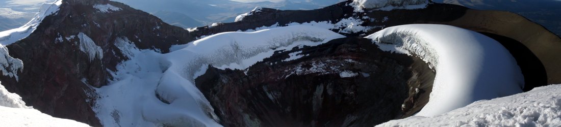
Eventually these cliffs of rock ended, and the trail led up a short scree slope to the crater rim. Now it became an easy walk as we followed a gravel ridge up and over several summits. It seemed that now all we had to do was walk along the ridge and up to the main summit, but after some distance the ridge swung to the left and the way was blocked by a pointy, jagged tower of rock with a notch in it.
Pablo scrambled across to the notch. I followed behind him, but it very exposed and I didn’t like it at all.
‘You might find it easier below,’ Pablo said, pointing his finger to the right of the rock tower.
I looked across the ridge and I could see that if I dropped a few metres below the rock tower, there was an easy path leading below it on the other side. It was a no-brainer, and I turned around to follow this much easier route.

Edita decided to go Pablo’s way instead, and by the time I wandered round to the other side on my easy trail, she had reached the notch but was struggling to do the splits to get across it. I waited below and watched this display of high-altitude gymnastics until they were both safely across.
I was now standing below them, and I could see my easy trail continue below another rocky tower. But Pablo shouted down that he could see the summit 60m away.
‘60m? That’s quite a lot,’ I replied.
When I scrambled up for look, I could see that the summit cross was around a corner. It was a tricky scramble to the corner, and beyond it the ridge dropped down again before climbing back to the summit. There was no way of knowing what was the other side of that drop without scrambling along to the corner.

The easy path below must be the right route, and by the time I had assessed all this, Pablo had descended to my original position and decided to take it. We followed behind him. Sure enough, it passed beneath a wall of rocks to a position 5m beyond the summit. Here a breach in the wall provided a way up.
We reached the summit at midday. We could see nothing at all in the thick mist, but there was clearly a steep drop on three sides. We had some lunch and measured the altitude (4,640m).
Some idiots (Jefferson Tiriro and Martin Lopez to be more specific) had scrawled their names in white paint on the summit rocks. Even worse, the Los Lobos Trekking Club had chosen to do the same in black paint beneath the summit cross. I don’t know who the Los Lobos Trekking Club are, but if you’re reading this and thinking of joining them, don’t. They are charlatans.

We left the summit at 12.30. The mist cleared briefly on the way down just as we reached the end of the walk along the ridge. Pablo pointed out the view behind us as the clouds passed over. We were clearly on the remains of a giant crater and the route between the first and second summits had been gradually curving round it.
We now had nothing to fear from the scrambling, but it was longer than I remembered it from the ascent. Pablo lost the trail at one point on the descent from the first summit to Inizio de la Roca, which could have landed us in trouble. Luckily he was quick to notice and we scrambled across to regain it.
Back at Bosque Polylepis, the clouds had cleared sufficiently for us to see the apron of forest below us. It now became clear how this col came by its name. The trees were tiny, but they could have been ancient. In Ecuador they are know árbol de papel (‘paper tree’) because of the way thin layers of red bark peel off the trunk in sheets. We stopped on the ridge and looked out across the forest as we finished our lunch.

Back on the grasslands it was a rapid, knee-jarring descent back to the car. We arrived at 3.45. We hadn’t seen much of it, but the summit was ticked. It had been an enjoyable ascent over a diversity of terrain, but I couldn’t help reflecting it would be a great one to climb on a sunny day with clear views. I think I might have to go back some day.
Sod’s Law had it that the clouds cleared away as we drove back to our guesthouse. At least this meant that we had another view of the mountain on the way back. Edita asked Pablo to stop the car beside Lago San Pablo to take a photo across its water.
She pointed her camera out of the window. A local man carrying a carpet hesitated before walking in front of her shot. He turned to the camera and gave her a smile.
[*] There is an interesting post about polylepis trees on the excellent Not Your Average American blog, a great travel blog to follow if you’re interested in Ecuador.


