
You can’t go far wrong with Ecuador if you’re into peak bagging: 28 volcanoes of various shapes and sizes, some lovely views and nice haciendas to relax at in between.
I went there six years ago and had a very successful trip, climbing five peaks, including two of its four big glaciated volcanoes, Antisana and Cotopaxi. But I didn’t climb the biggest mountain, Chimborazo, because it was in poor condition that year.
It was Edita’s first visit to Ecuador, but she has friends there who are mountain guides, and she suggested we go this year. I contacted Javier Herrera, who runs the expedition company Andeanface based in Quito. He had a trip running over the Christmas period that involved ascents of several volcanoes I didn’t climb last time. He also arranged for us to climb Chimborazo afterwards.
They’ve built a new airport since I was last in Ecuador. The old one was right in the heart of Quito, and the planes seemed to scrape the tops of the buildings as they came into land. The new airport is about 45 minutes outside the city on one of the few areas of flat land. They’ve built a new three-lane highway linking it for most of the way, but there’s still a part of the journey where the road launches up a forested gorge on a cobbled lane ascending in steep zigzags. I briefly wondered whether we’d been kidnapped by the wrong driver and driven into the countryside to take part in some ancient Inca ritual, but was reassured when the vehicle emerged at the top of the gorge into a town square where city residents were celebrating Christmas. Still, at least it’s not like Kathmandu, where you have to dodge cows to get from the airport to your hotel.
One of the benefits of climbing in Ecuador is that you start acclimatising as soon as you get off the plane. The new airport is at 2400m, and Quito itself is at 2850m, making it the second-highest capital city in the world (after La Paz in Bolivia). This wasn’t enough for Edita, though. On our first day in the country we had to climb the 115m towers of Quito Basilica, then walk up to the 3016m summit of El Panecillo, a popular viewpoint overlooking the city (most people take a taxi up, not just from laziness, but because the narrow staircase leading up the side is known as a popular venue for muggings).
Pasochoa (4200m)

After a day of acclimatisation, we set off in a bus for our first peak, 4200m Pasochoa, an extinct volcano just south of the city. On the way we picked up three members of our team, Martina, Bruce and Hilda. They were standing in a rough area of grass beside the main highway, with their backpacks at their feet. We wondered whether they’d been camping there, but it later emerged they’d been staying in a plush hacienda up on a hill, with fireplace, garden and free wifi. They were mother, father and daughter, and Hilda ended up being the only member of the team who managed to go the whole week without swearing.
Pasochoa turned out to be an easy day hike up through the páramo – a high-altitude landscape that is common in the Andes, characterised by tall paja grass and unusual alpine bushes and flowers. The mountain had quite an interesting summit ridge, which fell away gradually through the grasslands on the side we’d been ascending, but plunged dramatically through jungle on the far side. This turned out to be the long-since eroded and overgrown inside of the crater, with our ascent route being the outside of the volcano.
We climbed up the crater rim to Pasochoa’s northern summit for great views of Quito sprawling in a lush valley far beneath us. The three summits of Pichincha rose up behind it, and on the skyline around us we would have seen Cayambe, Antisana and Cotopaxi (three of Ecuador’s big four) but for cloud masking their tops.
I have a suspicion ours was not the main summit of Pasochoa, however. As we looked south in the direction of Cotopaxi and Rumiñahui we could see figures reaching a more prominent point on the crater rim a short distance away. It looked like this point was a few metres higher than we were. A full traverse of Pasochoa’s summit ridge would make a great day walk.
Corazón (4790m)

Corazón, which means heart in Spanish, takes its name because it’s supposed to be a heart-shaped mountain. I’ve viewed it extensively from the south, east and northern sides, and although there may be some body parts it resembles I’ve been unable to see any approximation to a heart.
That said, it’s quite a striking whale back of a peak which rises gently through grasslands until about 4000m, before rising abruptly in a rocky dome. It was a step up from Pasochoa, which had been a gentle hike. Corazón was going to involve some scrambling too.
In common with Pasochoa, and nearly every peak in Ecuador, we were able to drive most of the way up on a rutted dirt track, and parked up in boggy grasslands at 4000m. We were into the clouds more or less straight away, and apart from a few tantalising glimpses down into Ecuador’s cloud forest west of its Central Highlands, we had barely any views all day.
We still had plenty to enjoy though. After a brisk walk up a grassy hillside we arrived on a ridge which took us all the way to the summit. It was windy at times, but as the ridge narrowed we were faced with some interesting if straightforward scrambling. Some sections were probably quite exposed, but we could see nothing of the drop because of the cloud.
The summit was bare, with just a few jagged boulders and a modest cairn. Our two Canadians, Kristy and Stéphane had better reason than most to remember it. Stéphane surprised Kristy by producing a ring and – possibly suffering from altitude-induced hypoxia – she said yes. Their engagement was nearly the shortest on record. Stéphane dropped his trekking pole off the side of the ridge during the descent, and we watched in horror as he dived after it. Happily he was able to catch the pole with one leg still on terra firma and all was well.
We stayed in a nice hacienda at the foot of the mountain called the Chiquiragua Lodge, named after the distinctive orange flower of the páramo, which springs from the grasslands like a flame. However, I was unable to convince Stéphane that it’s a tradition in Ecuador to celebrate your engagement with champagne.
Iliniza Norte (5126m)

The Chiquiragua Lodge was conveniently positioned for an easy three-hour walk up to high camp on Iliniza the following day. Edita and I walked with our guide Romel, but upon discovering that he was an enthusiastic chef, they had a conversation about food that lasted nearly an hour. I became hungry and had to drop behind in order to preserve my appetite for the climb.
Iliniza is formed of two 5000m peaks separated by a 4700m col. The highest, 5248m Iliniza Sur, is still glaciated, and is known as something of an alpine technical challenge (though reports I’ve been given about its difficulty have varied widely from relatively straightforward glacier walk to super-technical ice climb needing two ice tools).
Iliniza Norte (5126m) no longer has any ice on its main route up from the col, and is no more than an extended rocky scramble. It was the only mountain I had climbed before, though on that occasion we were overtaken by cloud on the way up and I had no views from the summit. We were blessed with better weather this time.
We camped in a pleasant grassy meadow at 4000m, looking across the plains to Pasochoa and the W-shaped peak of Rumiñahui. The following day we left at 5am, an hour before dawn, and ascended a sandy pathway through the tufted grass. It appeared to be cloudy when we set out, but it was a very fine mist which soon cleared.
As the sun rose, so did the two peaks ahead of us. Iliniza Sur was a shadowy isosceles triangle with a splash of white colouring its top, but Iliniza Norte’s scree-laden east face became bathed in an orange glow from the rising sun. It had two distinctive summits like a fishtail, and the face was scarred with rocky outcrops which formed a long ridge up from the col. It looked severe, but I knew the route that followed this ridge was mostly a steep hike with a few modest scrambles.
We followed a gentle spur that came down from the col like a ramp, and reached a hut, Refugio Nuevos Horizontos, just below the col, at 8am. Here we made friends with an Andean fox scavenging for leftovers from the hut, and stopped for 20 minutes for mugs of coca tea.
A wind whipped dust into our faces as we left for the col, but once above we were sheltered by the rocks. We made easy progress up the ridge, with little to compare with the scrambling on Corazón, but the most southerly of Iliniza Norte’s summits was a rocky pinnacle with no way up. The trail skirted to the right on an airy traverse. There were beautiful blue skies above us, but to the west Corazón was wreathed in a halo of grey, and dramatic Cotopaxi remained obstinately hidden behind much thicker clouds.
The path eventually turned to the left and took a direct line up a rocky chimney, before angling back to the left to emerge the other side of the rock pinnacle. From here it was a short scramble up to Iliniza Norte’s tiny summit, which we reached at 10.30. There was a small iron cross and the yellow, blue and red flag of Ecuador.
We had a windy descent, and took the quick way down the east face. This involved some enjoyable glissading down the scree, but I managed to get enough dust in my eyes to grit an icy road and make it safe for traffic. We were back at camp by 1pm, where I blinked away the rest of the afternoon in our tent while eating fresh mangoes. The latter were very tasty, but they are no substitute for eye drops.
Cayambe (5790m)

Cayambe is a very special mountain. The Equator runs right through it. It is the highest mountain at zero latitude, and you have to go to Kenya, half a rotation away, to find another peak that approaches it in altitude (5199m Mount Kenya).
We spent New Year’s Eve at nearby Hacienda Guachalá, one of the oldest haciendas in Ecuador, which once extended to 30,000 acres and had nearly 500 staff. The hacienda is now a family-run tourist lodge, but it still oozes history and is something of a museum. The family obviously have a good sense of humour, and many of the plaques they have erected in the grounds celebrate the hacienda’s less than salubrious past. In the nineteenth century it was a workhouse for debtors and thrived on virtual slave-labour. A chapel in the grounds once had a dirty priest who had four of five concubines and a congregation containing many of his own offspring.
It’s a custom in Ecuador to see in the New Year by burning a life-size mannequin representing the troubles of the old year. We had a bonfire of smoky eucalyptus branches in the hacienda’s cobbled inner courtyard, and a resident tried to convince as that another custom is to leap across the flames on the stroke of midnight and make a wish. When we asked him to demonstrate he set fire to his shoes in the process of executing the manoeuvre.
On the way to Cayambe the following morning we stopped on the Equator. An organisation called Quitsato has erected a giant sundial called La Mitad del Mundo (The Middle of the World), which advertises itself as the first and only monument on the Real Equator. The slogan is a dig at the other more famous Mitad del Mundo just outside Quito, that is said to have been erected a couple of hundred metres south of the actual Equator. A man explained to us how Quitsato has used a combination of the Andes’ mountainous geography and the sun’s rays during the equinoxes to uncover a number of pre-Inca archaeological sites. Any druids reading this may want to consider Ecuador for their next holiday.
A dusty road climbs through rolling hills, all the way up to Cayambe Refuge at 4600m. The hut is the launchpad for climbs of Cayambe, but the easy access means it’s not just a refuge for climbers, but for sightseers and day trippers as well. The dirt track was a highway for 4WD vehicles, and the sandy combe around the hut was a car park for much of the day. Climbers and day trippers share the same dining facilities, and the latter were not shy to peer into dormitories out of curiosity.
Luckily we were a large group of eleven people, which meant we had the private use of a smaller satellite hut detached from the main one. Ecuador’s tourism ministry has introduced draconian legislation to regulate its mountaineering activities. Even for an easy glacier walk like Cayambe it’s compulsory for every climber, regardless of their competence, to hire one official Ecuadorian mountain guide for every two clients. We were seven of us, which meant four guides.
Another strange quirk about mountaineering in Ecuador is that it’s become the custom to climb the big four glaciated volcanoes by leaving for the summit the night before. It’s not unusual to make night time starts on alpine peaks, to reduce the risk of rockfall and avalanches when the sun comes up, but in Ecuador they take it to extremes, often leaving before midnight.

There isn’t much to be said about our Cayambe climb, because we did the entire ascent in the dark, arriving on the summit at 6am, just as the sun was peeping over the horizon. We got up at 11pm and left shortly after midnight. The first section was up through rock for a few hundred metres. The glacier was very dry, and monotonous to begin with, but it wasn’t steep and we made good progress. The orange lights of Cayambe city sparkled on the plateau far beneath us, and somewhere to the west there was a lightning storm in progress. From time to time the clouds on the horizon flashed at us, but I was wearing a climbing harness and couldn’t flash back.
There was an awkward section of mini ice pinnacles higher up, and just beneath the summit there were more interesting serac formations and snow ridges for us to weave between. Hilda arrived on the top first with her guide David, and Romel, Edita and I joined her about ten minutes later.
It had been a relatively warm climb, but it was very cold on the summit and didn’t get much warmer when the sun came up. We put on warmer clothes and mitts, and waited on top for about 45 minutes as others arrived. There was a carpet of cloud beneath us, with only Antisana and Cotopaxi emerging above it to the south. The shadow of Cayambe was projected dramatically onto the horizon to the west.
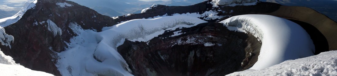
It was a picturesque summit for sure, but I had been spoiled by Antisana and Cotopaxi six years earlier, and Cayambe didn’t offer me anything more. Antisana had been a more interesting climb, and Cotopaxi had its magnificent summit crater that has now erupted again. I felt that we had left for the summit too early. I was disappointed about doing the entire climb in the dark, and on the way back down Edita had to tell me off for being grumpy. I understand the reasons, but it takes away some of the experience and makes the summit more of a tick in the box.
We were back at the hut shortly after 9am with the whole day ahead of us. Despite the slightly deflating experience on Cayambe, all four volcanoes had provided us with much variety and some lovely scenery. And Edita and I still had another mountain to climb, and that would prove a different proposition entirely.
Next week – Chimborazo, the highest mountain in the world (as they tell you in Ecuador).
You can see all my photos from the trip on Flickr, and I have made a short video for each of the peaks we climbed.


