
When the 1922 Everest expedition team arrived at their base camp in the Rongbuk Valley, Tibet, they already knew from their reconnaissance expedition the previous year that their approach to the summit of Everest lay up a side valley known as the East Rongbuk. But while they were familiar with its geography, they knew little of the terrain they would find there. Oliver Wheeler of the Survey of India had penetrated its lower reaches during his mapping in 1921, and the whole team had found a more roundabout route to the top of it over the Lhakpa La pass, but nobody had ascended the East Rongbuk Valley in its entirety.

What they found when they came to ascend it in 1922 was a tumbling mass of jagged ice towers the size of buildings, completely impractical to climb over even by today’s standards. They kept away from this impenetrable barrier for as long as possible by keeping to the left hand side of the valley, but when they were finally forced onto it they found there was a route between these impossible pinnacles after all, on the medial moraine which formed a narrow sliver of rock down the middle of the glacier.
Two years later the 1924 expedition team encountered a storm while their porters were ferrying supplies up this route, which led to their whole carefully calculated supply chain breaking down. Deprived of essential supplies some of them had to survive in -30º C temperatures on raw barley and a single blanket each (which they used for sleeping, not eating). By the time they managed to retreat to base camp loads were dumped by descending porters and strewn at random along the East Rongbuk Valley. Two of the men died from the injuries they suffered as a result of the storm, and the team gave the route the name Via Dolorosa or Sorrowful Way.
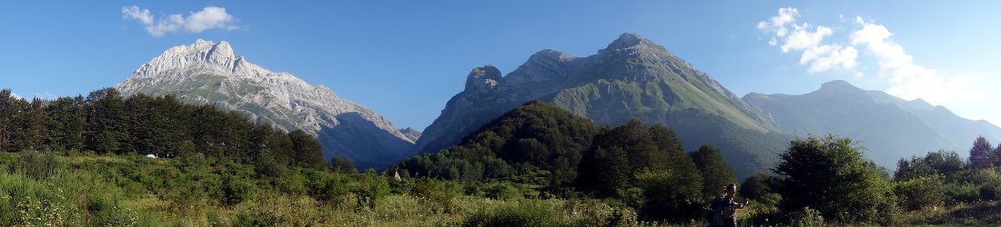
When I first ascended the East Rongbuk Valley myself in 2007, I found that although the terrain was rough underfoot and involved a great deal of boulder hopping, it was sufficiently straightforward for expedition teams to transport equipment up it on the backs of yaks. In fact, the four-legged furry bovines could make it all the way to Advanced Base Camp (ABC) at 6400m. The strip of moraine ran almost the entire length of the glacier, right up its middle. Although the jumble of uneven rocks and vast boulders made for difficult terrain underfoot, it presented a strenuous walk rather than a difficult climb. This moraine seems so remarkable it has become known as the Magic (or sometimes the Miracle) Highway.

So if the highway is miraculous (or even magical), why did the 1924 expedition team call it sorrowful? Partly this was a reflection of the unhappy time they had transporting supplies, but it was also possible the ascent was not so straightforward as it is now. The moraine is being carried on a moving glacier, of course, so it changes over time. A feature of the glacier is the sea of towering ice pinnacles which present an impassable barrier. Unlike the penitentes formations many people see on Aconcagua and other mountains in South America, which tend to be about the height of a man and formed by sun and wind on fresh snow over the course of a single season, these are dozens of metres high and created by the pressure of the glacier crushing its ice into ridges as it gradually flows down the valley. We called them sharks’ fins, and they must have seemed a difficult proposition to skilled climbers, never mind Tibetan porters carrying heavy loads.
Although many of the accounts written by members of the 1922 and 1924 expedition teams are quite understated about the difficulties they encountered, one that offers some insight is that of the cameraman John Noel:
“Between Frozen Lake and Snowfield Camps the glacier was twisted and broken into a belt some two miles wide of broken, splintered bergs of ice, some towering to a hundred feet in height. Here the men would strap steel spikes to the soles of their boots and set out along one of the strangest paths imaginable. They would find their way, turning and twisting in every possible direction, past the towers and pinnacles of ice, avoiding fissures fifty feet deep, descending walls of ice a hundred feet in depth, following old widened crevasses, climbing ladders that we cut in the ice, guided by a line of little flags we fixed to wooden pegs hammered to the tops of ice hillocks … Bergs and cliffs and crevasses blocked the way a dozen times to the first exploring party, and were circumvented only by retracing steps and starting afresh from some new direction.”
John Noel, Through Tibet to Everest

Anyone who’s seen John Noel’s recently re-released and slightly surreal film of the 1924 expedition, The Epic of Everest, might wonder whether they weren’t in fact doing the Hokey Cokey up the East Rongbuk Glacier. But this maze-like solution to the problem of ascending it clearly still existed in 1934, when the eccentric Yorkshireman Maurice Wilson went that way. Lacking any climbing skills he had a wild dream of climbing Everest solo and unsupported, and persuaded three Sherpas from Darjeeling to guide him to the foot of the mountain. They stopped in the Rongbuk Monastery at 5100m, leaving him to continue alone. He found the easy moraine route on the lower part of the East Rongbuk, and managed to reach John Noel’s Frozen Lake Camp at around 6000m without undue difficulty. Above this, however, he became lost and confused and failed to reach ABC (known then as Camp 3) at all during his first attempt.
So when did this straightforward route up moraine start getting called the Magic (or Miracle) Highway? Who coined the term, and is it the Magic Highway or the Miracle Highway? I’ve been searching for the answer to this question during some research for a book I’m writing, but have so far drawn a blank (as the bishop said to the actress). As far as I’m aware nobody used the term during the four major British expeditions to Everest of the 1930s, and for nearly half a century afterwards hardly anyone went that way. After the Second World War the Chinese annexed Tibet and the country became closed to outsiders. Two big Chinese expeditions to the north side of Everest took place in 1960 and 1975.
It occurred to me that perhaps the words magic and miracle are being used interchangeably due to a translation of the phrase into English from another language. One of the first westerners to attempt Everest from the north when Tibet opened up to foreigners again was Reinhold Messner. He made a solo, unsupported ascent along a new route across the North Face in 1980. I recently read his book about the climb, The Crystal Horizon, to see if it held the key, but I discovered Messner found nothing magical about the route up the East Rongbuk Valley:
“It is the only place in the world’s mountains where yaks can climb to 6500 metres. That is possible only because a mound of detritus winds between two mighty streams of ice as far as the ice face under the North Col.”
Messner prefers to do things the hard way, so magic isn’t the sort of word he would use for something that makes it a bit easier. But if he didn’t, who did? If you think you may have an idea then do please let me know in the comments. In the meantime: here are some yaks leaping down the Magic Highway.


Interesting Mr Horrell, I had always been under the impression that Georgie boy had named it the Miracle Highway in 1924. You cannot find any evidence of this?
Not in the main expedition books, unless he mentioned it in his letters. In 1924 they called it the Via Dolorosa.
What gave you the impression it was Mallory? It feels to me like a more modern phrase.
Hi Mark
Great site and great posts.
How about any info regarding the infamous Fantasy Ridge on Everest’s North side.
You must be tired out regarding the south side that Trekkers and climbers alike aspire to.
Any info or anecdotes would be greatly appreciated…
Thanks, Martin, I’m glad you like the content. The Fantasy Ridge on the Kangshung Face? If I remember rightly that’s a line that really was named by Messner.Â
Heehee, I’m flattered you have such a good opinion of my climbing ability, but I’m sorry to say the day I tire of the easy routes will be the day it’s time to hang up my ice axe. 😉
Thanks for the reply Mark. As for all our abilities, it’s just about getting out there and exeriencing the mountains wherever they are..keep up with the great site and we’ll all keep reading..
Martin
I’ll drink to that. 🙂
The Fantasy Ridge has only been attempted once, by an American expedition back in 2006. They called it off because out of condition. The Ridge was called like this by George Mallory, “supposedly because he thought it could only be climbed “in one’s imagination.””. Messner didn’t name this line, what he did was referring to the SW-pillar of K2 as “The Magic Line”.
Pingback:[VoxSpace Life] The Mount Everest Expedition : Asha Rani And Anmish Varma's Journey To The Summit