
For many years I escaped Christmas (and winter) by fleeing to Africa or Latin America for a couple of weeks over the holiday period. Over the course of 15 years Ethiopia, Uganda, Mexico, Argentina, Guatemala, Ecuador, Tanzania, Morocco, Chile and Colombia all featured among my Christmas holiday destinations.
The idea of a week in Scotland at the end of December was far from my thoughts. For one thing, there isn’t much daylight. In the Highlands it’s dark by 3.30pm. Then there’s the weather. You’ve got to be lucky with it during the summer months. In December there’s a high chance you’ll be pissed on every day and be faced with thick mist and howling winds over the hills.
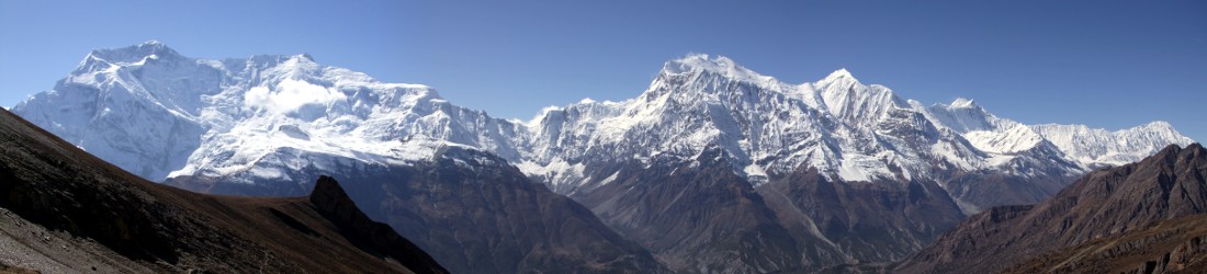
Of course, when the sun comes out it’s lovely: blue skies and a carpet of fresh snow on every peak and valley. But you can also get that in Morocco where such conditions are much more common.
Christmas in Scotland? Madness. Or so I thought for many years.

My years of winter globe-trotting came to an abrupt end in 2020 when COVID-19 curtailed international travel. For many months all hiking had to begin at my front door. By Christmas 2021 Scotland had become an exotic holiday destination and Edita and I decided to give it a try.
It worked out quite well. The weather was only horrendous for half the time and we stayed in a peaceful cottage beside a secluded sea loch in a stretch of crinkled coastline that could have been designed by Slartibartfast. We even managed to get up a couple of Munros, including Scotland’s most northerly, Ben Hope (although extreme weather conditions meant that it took two attempts).
This comparative success encouraged us to repeat the experience this year. Driving to Scotland is much cheaper than flying to Quito, or even Marrakesh. It’s also better for the planet. We don’t need to hire a guide: I have a map and compass, a subscription to OS Maps and a profusion of guidebooks. The deciding factor was provided by the UK Border Force, who announced a series of strikes over the holiday period designed to make the airport experience even more painful than it already is (which, as everyone knows, is excruciatingly so).
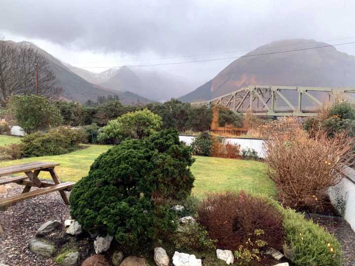
Edita booked a cottage right underneath the bridge over Loch Leven in North Balluchulish for a week. Well, OK, it wasn’t right underneath, but if you swung a cat from the bridge you could get it to land in the garden (we didn’t try this — I was just using a figure of speech). The cottage was a short stagger from the bar of the Loch Leven Hotel and provided convenient access to all the peaks in Glen Coe. This was exciting for me because I’ve driven through this dramatic and historic valley on almost every visit to Scotland, but I’d never got round to climbing any of its mountains.
Winter hillwalking is highly recommended, but you need to be selective. In December there are only seven hours of daylight each day, so routes need to be kept short (unless you’re prepared to walk in the dark). Depending on snow conditions, hikes usually take longer than the estimates given in guidebooks. If there is a lot of fresh snow then north-facing slopes become an avalanche hazard. As well as checking the Met Office Mountain Forecast it’s worth glancing at the website of the Scottish Avalanche Information Service if you’re going to be going high, where detailed risk assessments are provided for specific peaks, altitudes and aspects.
You’ve also got to be patient and flexible. Clouds and thick mist make navigation difficult, although this has become less of an issue in the era of smartphones. High winds are more of a deal breaker now, as I discovered on Ben Hope. It’s more than likely there will be days when the weather is so bad that hills should be avoided and only low-level walks are possible.
We arrived at the cottage on Christmas Eve, accompanied by our friends Bernadeta and Mohit. Edita and I had brought our axes and crampons, with the intention of climbing some more Munros in the course of our week if at all possible.

The weather forecast soon forced a lowering of our ambitions. Heavy rain was forecast every day for the entire week. Winds on the summits were going to be in excess of 30mph with gusts of over 50mph. These were the sort of gales that froze my fingers on Ben Hope the previous year. Visibility would be poor, with the mountaintops in cloud for most of the time. Heavy rain meant heavy snow on the hills, creating avalanche hazards.
If we were lucky, there might be a possible window on Wednesday 28, when winds could drop into the mid-teens. This offered an opportunity to make a dart for a summit, but by then there would be a lot of fresh snowfall, so we would need to be careful about which route we chose. Otherwise it was going to be a week of lower level walking. On the plus side we did have a couple of useful guidebooks containing good shorter walks: the Pocket Mountains guide to Fort William and Lochaber by Keith Fergus and the Collins Rambler’s Guide to Ben Nevis and Glen Coe by Chris Townsend.
On Christmas Day, Sunday, we chose a 2-hour walk along part of the West Highland Way high above Loch Leven. The walk included a visit to the Grey Mare’s Tail, an impressive 50m waterfall near the village of Kinlochleven. This proved to be rather more exciting than we anticipated. Some steel via ferrata cables had been installed beside steep rocks, allowing more intrepid hikers to scramble right up to the foot of the falls. Beyond these a rudimentary bridge had been erected across the river in the form of an iron bar to balance your feet on, and a loose cable at shoulder height for steadying yourself. The words loose and steady don’t usually go together. I’ve spoken previously about the dangers of castration while crossing this particular design of Scottish bridge. I’m still not ready to sacrifice my goolies for a better photo, so I chose to stop at the bridge. Edita, however, crossed right over, happily without mishap.

On Monday we had to go to Nevisports in Fort William for some urgent outdoor clothing supplies. It was another snowy day, but we managed to combine the trip with our first summit of the week, 287m Cow Hill, which rises above the town. Some of you may say that 287m is more of a cow pat than a cow hill, but there is a well-maintained footpath that circles the peak, contouring high across moorland and wending through pine forest. The summit itself commands fine views of Ben Nevis and the peaks of Glen Nevis to the east, and across Fort William and Loch Linnhe to the west. It’s a nice afternoon hike for days when the mountains aren’t recommended.
On Tuesday the weather forecast was still foul; not the conditions for attempting a Munro. But Edita and I decided we simply had to climb a decent peak. We chose Sgorr a’ Choise, a 667m trapezoidal peak rising up the valley from Ballachulish. Towering through the mist, it looked like a reasonable objective for a day such as this.
It proved to be a tiring walk, mainly because there was no good trail and there had been a lot of fresh snow. We came up the mountain via its south-west ridge, which involved a rough scramble up heather-clad slopes encased in a foot or more of powder snow. Edita did all of the trail-breaking, and still I was completely unable to keep up with her. I waded my own lonely path in her wake, sometimes 50m to 100m behind.

At the top it was blowing a gale, and it took us a couple of attempts to find a sheltered enough spot to sit down and eat our lunch. We dug ourselves some seats in an icy bank just below the summit and tucked into sandwiches and hot tea.
We could see a forestry track far beneath us that led up to a smaller hill, Am Meall, that was topped with a radio mast. From the mast it was a short descent back to Ballachulish. But to reach the forestry track we had to descend from Sgorr a’ Choise in the opposite direction, wading through deep snow to reach a col beside a high deer fence, then descend a steep hillside into pine forest.
It was an atmospheric descent through the forest. Branches were hung with lichen, but it was easier going than the grassy hillsides because the snow was patchy and we crossed a carpet of pine needles instead. There wasn’t much daylight remaining, but once we located the forestry track that we’d seen from the summit, we could make more rapid progress, revelling in the easy trail after hours of rougher terrain.

Even so, I was feeling pretty shattered by the time we passed across Am Meall and lolloped down steep slopes back to Ballachulish. Our mountain may only have been 667m high, but I felt like we’d done a proper hill walk. Doubtless it would have been a piece of piss in summer conditions, but not today.
The final part of the walk was quite pleasant. The area of woodland above the village of Ballachulish, known as Brecklet, is marked by a series of slate quarries that have been left to return to nature, and there is a network of well-maintained trails. We managed to make it down just before dark and I was pleasantly surprised to emerge from the woods right opposite the car park.
Wednesday was the day we had earmarked as our one and only opportunity to get up a Munro in this wet and windy week. However, our struggles on Sgorr a’ Choise had tempered my expectations. The fresh snow had slowed us a lot; there clearly wouldn’t be enough daylight to attempt a big hill walk across trail-less terrain. The other problem with Glen Coe is that most of the main routes on the Munros go up steep, north-facing slopes. These would pose an avalanche hazard after the fresh snow of the last three days.

There was one possible option, however. The Pap of Glencoe (Gaelic name: Sgorr na Ciche) is a prominent tit rising from the shores of Loch Leven above the village Glencoe (before you write to complain about my choice of language, I should point out that this is not my word — both the English colloquialism Pap and Gaelic Ciche mean breast). At 742m it’s not high enough to be classed as a Munro (or even a Corbett), but it perches beneath the shoulder of a higher peak, 967m Sgorr nam Fiannaidh, which is. Sgorr nam Fiannaidh is the westernmost summit of Aonach Eagach, one of Scotland’s most fearsome ridge scrambles. Its approach from the west, however, is more straightforward. The slopes are gentle and would pose less of an avalanche risk. Better still, the winds were easterly that day, instead of the prevailing south-westerlies. This meant we would be sheltered from the wind until we reached the summit plateau.
The weather forecast even suggested good visibility until 2pm. We could certainly climb the Pap of Glencoe, and if we made good time then we had the option of bagging a cheeky Munro too.
We made an ‘early’ start and set out from the woodland car park near Glencoe village at the crack of dawn, which on 28 December in that part of Scotland is 8.45am. I had forgotten how much easier things are on a well-maintained trail. It was a steep ascent straight from the road. After only an hour of walking we were high above Glencoe and looking west across the silver waters of Loch Leven. The radio mast of Am Meall was far below us and we had already reached the place where the trail forked, just below the col between Pap of Glencoe and Sgorr nam Fiannaidh. It was a no-brainer to turn right and head up the Munro. We could easily bag the Pap on our way back.

It took only 1½ hours to reach the summit from the fork. We crossed patches of snow shortly after the junction. This made it harder to see the trail, but the views were clear and navigation was easy as we zigzagged up natural lines in the rock. We had crampons in our bags but we didn’t need them. Because the terrain wasn’t steep we had also chosen to leave our axes behind, taking only trekking poles. It was the right decision.
Once on the summit plateau we finally got the magnificent mountain views we had been hoping for all week. We were looking up Glen Coe towards Buachaille Etive Mor, the dramatic rock peak that stands at the top end of the glen like an entry gatepost. Across the valley to our south were the four summits of Bidean nam Bian, Glen Coe’s highest peak, while to the north we could look across the Ring of Steall to Ben Nevis, the highest mountain in the British Isles, bedecked all in white like a ghostly maiden.
We were no longer sheltered from the wind. A light breeze drifted across the plateau and it became a little colder. There was a firm crust of snow on top of the ridge. I broke trail through it, plunging six or eight inches with every step, but the terrain was flat and it posed no risk.

We reached the summit at 11.30. To the east was the rest of Aonach Eagach. We could see several summits and pinnacles, but it was impossible to make out the ridge. We sheltered behind the west side of the summit wall and had a 15-minute lunch, but we could already see grey clouds assembling, so we didn’t hang around.
We had seen no one all day, but shortly after leaving the plateau we passed an older couple coming up with ice axes. They would not have enjoyed the summit as much as we did, because the storm arrived early, at 12.30, while we approached the fork. Here we came across a pair of Frenchmen who had unpacked their stove to have a brew as they debated whether or not to continue to the summit of Sgorr nam Fiannaidh. It didn’t seem the time or place, either for continuing up a Munro or stopping for elevenses. Presumably the weather, which was rapidly deteriorating, made up their minds for them.
By now it was raining heavily. I was all for calling it a day and heading back to the car, but Edita insisted on going up the Pap of Glencoe as well. It took us a further 45 minutes to reach its summit from the fork, during which a pleasant mountain walk became a little more epic. The trail corkscrewed around the east side of the Pap to climb to the summit in a series of high steps in the rock. The wind was blowing a gale and snow lashed against us like icy needles. It was a bit of an ordeal, but we continued onwards. I have to confess than in some perverse way it made the day more satisfying.

On the summit it emerged that the wind gods had been indulging in a breakfast of baked beans. We could barely stand up and it wasn’t a place to hang around. The view was still clear from the top but the higher peaks were now in cloud. We took rapid summit pics then descended back into the teeth of the gale. We raced down after that, overtaking the older couple we saw on their way up Sgorr nam Fiannaidh. We arrived back at the car at 3pm after six hours on the two hills. I was in much better shape than I had been the previous day. Sgorr nam Fiannaidh and the Pap of Glencoe were higher peaks, but the better trail had made it far less tiring than the rough hillsides of Sgorr a’ Choise.
Later that evening, Edita posted photos of our climb to Twitter and was surprised to find her phone buzzing with notifications for the rest of the evening.
‘What’s going on? I normally only get one or two likes for my tweets, and one of them is always from you,’ she said.
‘Somebody big must have retweeted you,’ I said (which ruled out me).
It turned out that she had been retweeted by Chris Townsend, a legendary figure in the UK outdoor community.
I whipped out our copy of the Collins Rambler’s Guide to Ben Nevis and Glen Coe. ‘Look — it’s the guy whose guidebook I’ve been using!’

This proved to be the high point of our week. From then on things deteriorated. The forecast was so bad that any more hillwalking was out of the question. On Thursday we honoured Chris Townsend with another low-level walk from his guidebook. We did a circuit of Buachaille Etive Beag that cut across the mountains from Glen Coe in the north to Glen Etive in the south via the narrow valley of the Lairig Eilde, then back again via the Lairig Gartain.
The outgoing leg was quite enjoyable as snow fell in giant flakes like confetti and we descended into the more peaceful valley of Glen Etive. But there were about 73 river crossings, and the water was always in full spate. Our trekking poles would have been useful to help us step across on submerged stones, but we hadn’t brought them. With big leather walking boots and waterproof trousers it’s possible to wade across without getting your feet wet if you walk quickly enough. This technique worked for the first few crossings, but Edita’s right foot eventually took a soaking and this caused her toes to gradually freeze.
To cheer her up I decided to stick my leg down a hole in the path and pretend that I’d fallen in. This prank backfired when I discovered that I couldn’t get my foot out again. I had to reach down and unlace the boot. After she’d finished filming my predicament, Edita hauled me out like a sack of coal and I was able to stick my hand in and retrieve my boot.
For the benefit of the outdoor community, here’s Edita’s footage of the incident, to deter those of you who might also be tempted by stupidity while out hiking.
Soon after this the sun gave up trying and surrendered to the clouds. The rain gods chose this moment to do their laundry, and we had been several times through the spin cycle by the time we returned to our car on the A82 in Glen Coe. The human body is supposed to be about 60% water, but by that time we were closer to 90.
Friday was similarly wet, and an hour of trooping around Glencoe Forest was quite enough for us before we retreated to the Clachaig Inn to dry out by the fire.
Some of you may be reading this and thinking that it’s a fairly pitiful performance since the heady days of climbing Everest. This would be fair comment. But going up mountains isn’t the be-all and end-all. Sometimes you’ve just got to chill out and enjoy the easier trails too. We certainly did that in spite of the weather.
You can see all my crap photos from the week in the Flickr album Ballachulish.


Thanks. I always enjoy your stories, whether it’s Everest, a Munroe,, a low walk, or a book review.
Thank you, that’s nice to hear 🙂
I loved that ‘snow and blue skies” comparison with Morocco, haha. Edita on the Scottish monorail bridge looks lethal! Nasty season but good story Mark.