
There are times when a trip seems to be blessed with serendipity at every stage. Chance encounters and events seem to fall into place as you make your way around.
Ten years ago, I had just such a trip to the Annapurna region of Nepal. It was a time when the Annapurna Circuit was still very popular, but the surrounding areas which see more visitors now were only just starting to open up. These areas were rarely explored, and trekking among them gave you a feeling of pioneering adventure.

I trekked the Annapurna Circuit in 2006, unguided and unsupported — just four friends and our backpacks. You could do that on the Annapurna Circuit because there are teahouses every few miles, which means food and accommodation. But just a few miles off the Circuit, things felt much more remote.
A couple of years later I joined a trek my friend Siling Ghale had organised to explore some of the more remote surrounding areas. He had put together a fully supported camping trek, complete with kitchen crew and an army of porters. Siling was born and raised in the village of Braga near Manang, on the northern part of the Annapurna Circuit. It was his home patch, but even he was relishing a chance to get off the beaten track.
We went north of the Annapurna Circuit to the dry, desert region of Naar and Phu. We travelled west of Manang to visit Tilicho Lake, sometimes described as the highest lake in the world (debatable). We avoided the Thorong La, the high point of the Annapurna Circuit, and took an alternative pass, the more technical Mesokanta La, into the Kali Gandaki valley on the western side. And on the way, we climbed an obscure trekking peak called Chulu Far East (6,058m).

The trek was full of variety and memorable moments. For the first four days we trekked along the Annapurna Circuit. In every teahouse we stopped, we found ourselves sharing it with Phil Crampton, whose Altitude Junkies team were on their way to climb Kangguru, a 7,000m expedition peak in the Naar Phu Valley. Phil’s stories left a deep impression, and I ended up joining him on several 8,000m-peak expeditions.
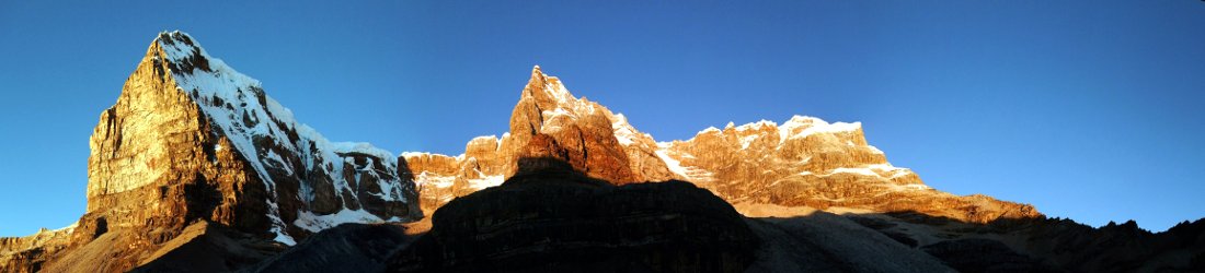
The trail north of the Annapurna Circuit into the Naar and Phu region cut through the dramatic Naar Phu Valley, a narrow gorge that was wonderfully forested. The trail was hewn into cliff faces, and at one point it passed behind a waterfall.
On the other side of the gorge we were still in Nepal, but we found we had passed through the Himalayan divide into a landscape that felt more Tibetan. We had left the jungle and forests behind and were now in a desert region bereft of vegetation but for a few dry stretches of grass and red leaves of the berberis.
Like the trails, the houses of Phu village were hewn into a hillside. At 4,000m altitude it was freezing cold, but above the village was a peaceful monastery in a dramatic location looking back down the valley. We spent a morning there basking in the tranquillity. It was one of those places and one of those moments where all of life’s troubles are far away.

Naar village was a marked contrast. It felt equally mediaeval, but the villagers were preparing for a festival, and they persuaded us to stay a few hours longer so that we could join in. We sat in a crowded square as monks whirled prayer wheels and villagers jumped around in colourful masks. At some point in the morning we left the village to continue our trek. A short while later, we were back in the quiet surroundings of desert and mountains, thinking to ourselves ‘did that really happen?’
The following day we crossed the Kang La pass to return from the Naar Phu region back into the Marsyangdi Valley on the Annapurna Circuit. Crossing a high pass often has a tendency to take your breath away. A single step as you crest a rise takes you out of one landscape and into another. But the Kang La was something else. Within the space of a few metres we found the entire length of the Annapurnas stretching in a line before us. There were six peaks over 7,000m in altitude — Annapurna II (7,939m), Annapurna IV (7,525m), Annapurna III (7,555m), Gangapurna (7,454m), Annapurna I (8,091m) and Tilicho Peak (7,134m).
I remarked once before, during the early days of this blog, that the Kang La was possibly the finest viewpoint in the Himalayas. I obviously haven’t visited every viewpoint in the Himalayas, but I still believe this statement could be true.

Chulu Far East was also a great discovery. People often describe Mera Peak as a ‘walk up peak’, one of those mountains that it’s possible to climb with very few technical skills. In fact, the summit dome of Mera Peak is somewhat technical, and you will need to climb a 30m ice wall. Chulu Far East can fairly be described as a ‘walk up peak’, however. You need experience of using an ice axe and crampons, and walking roped together, but the mountain is nothing more than a steep snow plod.
It’s surprising that Chulu Far East isn’t climbed more often by commercial groups. It’s the perfect beginners’ peak, for people who enjoy trekking and are looking to take their first tentative steps into mountaineering. Although it’s a straightforward climb, it does have a very narrow summit ridge. A photo I took of this ridge has been the subject of a number of requests from trekking companies looking to advertise their own trips there. Some, like the infamous Seven Summit Treks of Nepal, even use it without asking.
Upon our arrival in Braga, Siling was welcomed like a returning hero — the local boy made good and the first person from Braga to climb a 6,000m peak.

We had a rest day the following day and, as if they knew we were coming, a few minutes down the road in Manang they were staging a ‘horse race’. I use the phrase ‘horse race’ loosely. The centre of Manang has a dusty strip of land several hundred metres long that is perfect for racing horses up and down. And that’s exactly what they did. It wasn’t a competition, as such. There were no rules. The horses came in all shapes and sizes and the riders themselves were an even odder assortment. But for a few hours in the afternoon they raced up and down while crowds, including ourselves, watched from the sidelines.
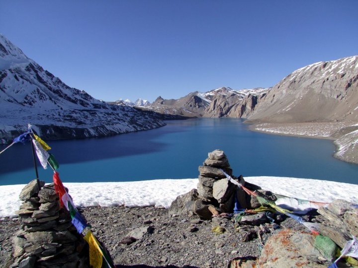
Ever since my first visit to Nepal in 2002, when I opened up a map of the Annapurna region and anticipated the adventure ahead of me, one feature on the map held my attention. Where the main Annapurna Circuit diverted north to cross over its highest point, the Thorong La, a side trail took a higher route across the flanks of Annapurna I. Here it passed Tilicho Lake, the largest lake and most intriguing feature on the map.
I could only imagine what this peaceful and remote body of water must be like. Now I had my chance and I discovered the answer. It wasn’t at all as I was expecting. A place to sunbathe surrounded by palm trees it was not. It lies at an altitude of nearly 5,000m and is sometimes described as the highest lake in the world. It was bleak as hell and freezing cold. Parts of the lake were frozen. But the scenery was amazing.
Our crossing of the Mesokanto La was also a little hairy. Few people ever cross this more southerly pass and we had to break our own trail. The steep pass was laden with snow and only one of our team (Mingma, who now runs a very successful Nepali mountaineering company Climbalaya) was carrying an ice axe. We had to follow behind as he cut steps for us.
It was like those stories of early mountaineering in the days before the widespread use of crampons. It was harder for our porters, but everybody made it across safely.
As we descended into the village of Jomsom on the Annapurna Circuit trail, 8,167m Dhaulagiri, the world’s eighth highest mountain, rose up like a frozen teepee. It was one of the best views I have seen of it.

Nepal is one of the best places in the world to combine dramatic treks with alpine mountaineering. Chulu Far East is rightly more popular now, but there are many more trekking peaks to explore that still receive very few visitors. I will always remember fondly those days when we helped to put Chulu Far East on the trekking map. Once in a while, I recommend going beyond the old favourites like Mera and Island Peaks and checking out some of these lesser known ones too.


Greetings again from Canada.. :)-
This trip seems like something out of a dream. It just seems to have everything. Thanks for taking us along. It’s magic, this one.
The Phu monastery you mentioned sounds intriguing. Got any pictures of it?
Sure. You can see all my photos from that trip here:
https://www.flickr.com/photos/markhorrell/albums/72157652977509685
Wow, I followed the links and the photography is outstanding. I noticed a large portrait of a lama on the altar in one of the temples in Phu, and I can’t help but wonder who it is. Are the local Buddhists Gelug, Nyingma, Kagyu, Sakya or none of the above?
The stone marked with the Maoist symbol got me thinking about the political climate. Are the Chinese still working on taking over Nepal? Are they having any success?
I don’t know about that, but we were told that in the 1960s and 70s the Naar and Phu area was a haven for Khampa guerrillas resisting the Chinese occupation of Tibet. There are several ruined buildings from that period.
Mark, I enjoy reading your blog. I would love to climb Chulu Far East some time. I did climb Saribung Peak (6328 m) last month. It was not technical and I had an amazing view from the top – into Tibet to the North, Dhaulagiri to the SW (only top visible), and from E to S: Lugula, Chyako, Ratna Chuli, Himlung, Himjung, Nemjung, Gyaji Kang, Manaslu, Ngadi Chuli, Kang Guru, Annapurna II, IV, III, Chib Himal (which is right in front and blocks a view of Gangapurna and Annapurna I). You can check out the summit panorama at
https://youtu.be/9e_HNzg0qJ4
What’s strange is that Saribung Peak is not classified as a trekking peak but is a full expedition peak.
Is it a good idea to climb Chulu Far East in May
Early May should be fine. The monsoon usually arrives in early June.