
When I stood atop Aran Benllyn in southern Snowdonia back in February, snow cover on the mountaintops caused several nearby massifs to stand out. To the west, rugged Cadair Idris and the elongated Rhinogs spanned the horizon, and to the west the gentle curves of the Berwyns painted a white ribbon across the lowlands. Even the more distant Snowdon massif on the northern horizon drew attention by rising into the clouds.
One range between myself and Snowdon, however, was less distinct – so much so that I completely overlooked it while describing the summit panorama to Edita in her summit video.

The Arenigs are a lesser known area of mountains in south-east Snowdonia forming a roughly triangular 500km2 area bounded by the A470, A5 and A494 roads between Dolgellau and Betws-y-Coed. You may be wondering, if they cover such a large area, how can I completely overlook them? Most of the peaks are not very high, in the 500m to 600m range, which meant they weren’t snow-capped that day in February.
Only three Arenig peaks surpass 700m, but one, Arenig Fawr, towers over the rest. At 854m, it’s more than 100m higher than the next biggest, 751m Moel Llyfnant. Had I been paying attention in Edita’s summit video, I would have spotted its snow-covered top rising quite clearly in front of Snowdon.
In the spirit of learning, I typed the word arenig into Google Translate to find out its Welsh meaning. My opinion of AI was further strengthened when it came back with arenaceous. You will know from last week’s post that I strongly suspect Google Translate of guessing when it doesn’t know the answer. This time I wondered if it had even gone as far as ‘doing a Shakespeare’ by inventing a word. I had to turn to a proper dictionary written by actual humans to learn that arenaceous is indeed a real word meaning sandy. Unfortunately, the summit of Arenig Fawr is grassy not sandy, so at this point I gave up trying to learn Welsh and opened a cwrw.

Arenig Fawr is the birthplace of the Arenig School of art, a short-lived early 20th century art movement that seemed to involve – and I should stress that I’m no art critic – producing exaggerated paintings of mountains in garish colours while drunk, and as quickly as possible before the sky clouds over.
On a more tragic note, like Rhinog Fawr, Arenig Fawr was the scene of a fatal air crash. In August 1943, during the Second World War, an American B-17 Flying Fortress aircraft set off on a night training exercise. It crashed into the mountain, killing all eight US airmen on board. There is now a plaque to their memory on the summit.
The mountain is only a short drive west of the point whence we’d started our climb of the Rhinogs. The bright weather was set to continue, so it felt like a good opportunity to climb it the following day.

Arenig Fawr is more usually climbed from the north-east, where the crag of Y Castell and lake of Llyn Arenig Fawr provide a picturesque foreground, like an outer rampart and moat. But to climb the outlier of Moel Llyfnant at the same time, it is easier to start from the north-west, so I chose this route instead.
It turned out to be a shorter walk than the previous day, when we’d arrived at our car tired and exhilarated after our challenging jaunt up and over the Rhinogs, To recover, we enjoyed a relaxing evening at the George III Inn, Penmaenpool. Our room overlooked the estuary where the great mountain explorer Bill Tilman spent his time between expeditions writing some of the best travel books ever written. Beyond the estuary, the northernmost Rhinog of Diffwys provided a backdrop. As rooms with a view go, it may not have quite matched the one we had in Plockton, with a view across Loch Carron, but it was up there.
We arrived at a lay-by just off the A4212 north of Arenig Fawr at 10am the following morning. We crossed a river on a minor road and took a footpath along a disused railway embankment. A short distance beyond this, a farm track slanted upwards across open grassland.

Two peaks appeared on our left. The one on the right looked distinctly higher, but on the map I could see no smaller peak rising to the north of Arenig Fawr. We turned off the farm track to take a rough path up a boggy hillside toward the left-hand peak, following the line of a dry stone wall.
A group of three young lads appeared on the hillside in front of us. They evidently weren’t regular hill walkers, as they were stopping to rest every few minutes. We trudged past them as they slumped on a bank looking exhausted (if I sound smug here, I should point out that, as usual, I was trailing in Edita’s wake and must have looked equally shagged out to them).
The mystery of the left-hand peak was explained when we topped the brow of a feature marked on the map as Craig y Hyrrdod (‘Crag of Rams’). It was no peak at all; merely a shoulder of Arenig Fawr. Once above what we thought would be our first summit, we could see our hillside narrowing to a ridge and continuing to rise as it curved towards the right-hand peak, which was the actual summit of Arenig Fawr.

We reached the top shortly before midday and took selfies standing on the summit wall. A large plaque had been erected to commemorate the fallen airmen. Another rock had been scrawled with graffiti and signed by a previous summiteer. Edita was ashamed to note that it bore a Lithuanian name and was dated only last year. She rearranged a section of wall to hide its unsightly presence from view.
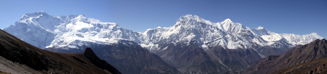
The panorama was less hazy than it had been the previous day, but although the sun was bright, visibility was far from perfect. Arenig Fawr is quite an isolated peak. Nothing in close proximity approaches it in height, and those peaks that do – the Arans and Cadair Idris to the south, and the Snowdon massif to the north – appeared only as faint outlines on the horizon.
It was too early for lunch, so we continued across Arenig Fawr’s south top before descending to an enchanting area of hummocks and lakes high above the surrounding countryside. It would be a prime location for a wild camp.

We ate our first lunch at 12.30, beside a cairn looking west to the gentle whaleback of Moel Llyfnant, the Arenigs’ second highest peak. To reach its summit, we could see that we would need to descend 200m to a bare col that looked suspiciously like a bog, before ascending 250m up the side of the whale.
Suspicion became certainty a few minutes later. We descended grassy slopes, following the faint traces of a path. But it was the wrong path, and it petered out on the fringes of the bog. Rather than retracing our steps back up the hillside to locate the correct trail, I decided to start wading across. Edita, however, is wiser than I am. She imagined me sinking slowly into the mire, until only my walking pole rose above the surface, like the final scene from Lorna Doone.
As my route became increasingly squelchy, a voice cried out behind me.
‘Stop it. Come back. You’re going to drown.’
We doubled back and found a way around the fringes of the bog to regain the proper trail, which followed a bank of more solid ground. The path continued up the east flank of Moel Llyfnant but again petered out short of our destination.

We became separated as we traipsed up steep, heather-clad slopes. Somewhere beneath the summit, we met up again, each heading in opposite directions. We eventually found the summit the other side of a wire fence. We arrived at 2pm and enjoyed a memorable second lunch looking across acres of open hillside. Apart from the fence, there were few signs of human habitation for miles around. To the east, beyond the bog we had crossed, Arenig Fawr really did have twin summits now, the lower south top giving it the appearance of a grassy Elbrus.
Our descent was rapid, across soft, green, gently declining slopes on the north side of Moel Llyfnant. Before we knew it, we had joined up with a forestry track, which took us past a derelict stone building and through a short burst of pinewood to reach the farm track we had taken on the way up.
We reached our car at 3pm after a memorable couple of days in two of Snowdonia’s lesser known mountain ranges. We will return.
You can see all photos from our walk in my Rhinogs and Arenigs Flickr album. And if you’re worried about following my GPX track below, you can rest assured that I reprogrammed the route to avoid my mazy way through the bog.
Route map
Arenig Fawr and Moel Llyfnant
Total distance: 13.45km. Total ascent/descent: 838m.
View route map and download GPX


