
Time flies quickly now. I was amazed to discover that, thanks to successive lockdowns and a focus on Scotland in the last few years, it has been a full four years since my last visit to the Lake District, England’s best hillwalking area.
A return visit was long overdue and the Easter weekend offered a good opportunity. After a March that only ducks could feel happy about, the weather was set to be fair that first weekend in April. Edita found a cottage in Kirkland, on the west side of the mountains, and we set our sights on the Northwest Fells, an area of peaks that I haven’t explored for many years, and only ever in impenetrable hill fog.

I was still in my 20s when I set off up Grisedale Pike many years ago from the village of Braithwaite near Keswick. The route up Grisedale Pike from the eastern side follows a prominent grassy ridge that steepens to a bare scree slope just beneath the summit. Or so I remembered it. Back in those days it felt quite epic.
By the time I reached the top I found myself in thick cloud. This was long before the days of smartphones and handheld GPS devices. I was able to navigate my way over Hopegill Head and down to the saddle of Coledale Hause by following faint paths, but things got tricky on the grassy slopes of Wandope and Crag Hill. Aside from a paper map and compass, my principal means of navigation was the route description in my guidebook, a coffee table hardback called The Lakeland One Hundred by John Drews which only just fitted into my rucksack.
Somewhere beyond Sail I descended into Coledale and a biblical rainstorm overtook me. As I stopped a few times to check the route, the pages of my guidebook turned into a cardboard sandwich. I still have the book, and I can’t ever read it without remembering that walk.
One hill that I hadn’t climbed that day was Grasmoor, the highest in the area at 852m and one that takes naming literally. Its summit does precisely what it says on the tin: it’s a grassy moorland plateau. According to Alfred Wainwright, however, its name derives from the same root as Grisedale Pike: the Old Norse word grise, meaning wild boar.

Would it prove to be a pig to climb? Most people approach Grasmoor from the east, a straightforward stroll up that grassy hillside. On its western side, Grasmoor is guarded by a series of crags known collectively as Grasmoor End. Opening up my copy of The Lakeland One Hundred again after so many years felt like opening an ancient grimoire. The pages were as rigid as Egyptian papyrus, and the words wafted from its rippled surface like magic spells.
Both The Lakeland One Hundred and another guidebook, the Collins Rambler’s Guide to the Lake District by John Gillham and Ronald Turnbull, described the same circular route over the tops of Grasmoor and the ridgetop of Gasgale Crags. But they described it in opposite directions. Both books agreed that the section over Grasmoor End was the crux. The latter guidebook, which started the route by heading straight up it, said quite explicitly that ‘this is the most serious route in the book’, while The Lakeland One Hundred described the descent as ‘very exposed and requires a good deal of scrambling’. Since it’s generally much easier to scramble up than scramble down, we decided to follow the route in the Collins Rambler’s Guide. My fear of accidentally invoking a Locomotor Wibbly curse if I memorised the text in The Lakeland One Hundred may also have played a part.
The weather forecast for the bank holiday Friday was the best of the weekend. We got up in the middle of the night, left the Cotswolds at 4am and raced up the M6 (at no faster than 70mph, just to be clear) to give ourselves a full day’s walking.
We parked up in the little roadside car park of Lanthwaite, just up the hill from Crummock Water, at 9.15. There was still plenty of space, but within minutes of our arrival, while we were still lacing up our approach shoes for departure, half a dozen more cars arrived, filling up the remaining spaces.

It was cold in the shade, with a bit of frost, but the sun was still over the other side of the hills, and we could see it would be sunny on top. Two peaks lay before us across lush grassy moorland. On the left, Whiteside was flat-topped, with a clear path descending from a gently slanting rib. The valley of Gasgale divided it from our immediate objective on the right. Staring up at the crumbled mass of tumbling rock outcrops and grassy terraces of Grasmoor End, it wasn’t easy to discern a route. It looked steep, but mountainsides always do when you look at them front-on. The description in the guidebook stated that the scrambling section zigzagged up these rocky outcrops from terrace to terrace, and there were a number of places on the face where this looked possible, most clearly on the left-hand side.
It looked a bit of a silly option from the various routes opening out before us. Most walkers seemed to be heading for the more obvious trail up Whiteside that we would be coming down at the end of the day. Smaller but still significant numbers were heading down the road to Crummock Water, presumably to tackle the standard route up Grasmoor from the south and east. We were the only idiots heading up this mad blob of jagged stone, but this was to our advantage. If you’re going to make fools of yourselves, better to do it with nobody else watching.
Below the rock outcrops, the lower flanks of Grasmoor End were paved in murals of grey scree. One of these was a beige tongue that looked to have seen greater footfall. We plodded up a green carpet of grass to the tip of this tongue and discovered that, sure enough, the trail headed up its right-hand side. It wasn’t the most pleasant of beginnings. We weaved our way up a bed of loose stones for about 200m until we reached firmer ground above the scree.
The going now became much easier. The trail between the rocky outcrops was absolutely clear from years of tramping feet. It weaved backwards and forwards from terrace to terrace. There were a few steeper sections where we had to clamber up rocks, but even these were so straightforward that many of them could be tackled without resorting to hands. I can see why the guidebooks might describe this as scrambling, but really it was in that grey area between scrambling and walking, depending on your competence and confidence.

However you define it, we had made the right decision. There were plenty of places to pause for breath and gaze out across the silver line of Crummock Water and the wooded farmland of Lorton Vale to the Irish Sea.
And for some reason, on this busy bank-holiday weekend we had the route to ourselves. I don’t know why, but this clear trail wasn’t marked on either the Ordnance Survey map or OpenStreetMap. The latter meant that it wouldn’t be picked up by many mapping apps either. I would never have found this hidden route had I not used a good old-fashioned guidebook. There has been a bit of hoo-ha recently about the dangers of relying on popular hiking apps that use crowdsourced maps. After a couple of high-profile mountain rescues, some of the more popular apps have been busily removing sketchier trails from their maps. I wondered if we were benefiting from this.
Using a guidebook has other entertaining quirks. The route description in the Collins Rambler’s Guide stated that the rocky outcrops just beneath Grasmoor’s grassy summit are home to nesting peregrine falcons. The description then veered off into a digression about birdwatching:
‘The casual birdspotter is unlikely to get close enough to distinguish the grey-striped breast, still less the black moustachial streak. Rather, he or she will recognise the various hunting birds by their jizz.’
To which the only appropriate response is: ‘I beg your pardon?’

Luckily the guide then stated that a peregrine flaps briskly like a pigeon or grouse, a hen harrier more closely resembles a seagull, while a buzzard soars like an eagle. This seems a simpler method of identifying birds than examining their semen.
The path went up a narrow rocky chute to what felt like the higher reaches of a buttress. After a series of more gradual inclines we arrived at the top of Grasmoor End. We emerged into sun at the end of a grassy plateau. My fleece beanie that I’d put on in a frosty car park was now sodden in sweat and I swapped it for a nylon cap.
We reached the 852m summit of Grasmoor shortly after 11am, and met our first people since leaving the car park. It had a roof-of-the-world feel. The summit itself is a rounded bulge marked by a shelter-wall on the edge of a vast plateau. Distant, mountain horizons surrounded us; most seemed a little lower than we were. It was a good place to soak up the sky.
The way forward lay across this grassy plateau. It gradually sloped downwards, and our next objective, 839m Crag Hill, emerged across a saddle. Lakeland deity Alfred Wainwright famously got the name of this hill wrong in his guidebooks, calling it Eel Crag, which is actually the name of the cliffs on its north side (I may be in danger of excommunication from the hillwalking fraternity for saying this).

There are no crags in sight when you approach Crag Hill from the west, as we did. To its left, the pointed top of 791m Grisedale Pike looked a more prominent peak, but as we descended to the saddle, we could see various groups heading up the insignificant bump of 772m Wandope, a grassy bulge in the skyline to the right of Crag Hill. I had actually climbed this on my previous trip, and in that blank mist I had wondered what was the point. The answer lay in the title of the guidebook, ‘The Lakeland One Hundred’ — it was supposedly one of the hundred highest peaks in the Lake District. Really? You could argue that it wasn’t even a peak. But with Alfred Wainwright already on my mind, I realised that the reason all those people were going up it was probably because it was one of the 214 peaks classed as a Wainwright.
I have no idea how many Wainwrights I’ve been up, but just in case Edita and I decide one day to start counting, I suggested that we make a small diversion and go up it now. For all my disparaging comments, Wandope was actually quite a nice viewpoint, looking across Newlands Pass to the peaks of Robinson and Hindscarth that we intended to climb the following day. The Newlands Valley was to gain notoriety later that week, after mountain rescue volunteers were called out to help a group of hikers who found themselves in trouble after getting high on magic mushrooms. Had I known about this at the time, I’d have been tempted to get down on my hands and knees and look for some.
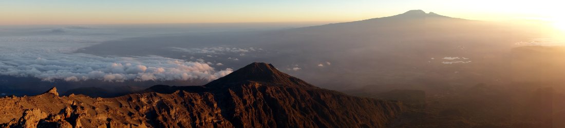
Likewise Crag Hill is a great viewpoint for the northern fells of Skiddaw and Blencathra. From the broad stony summit of Crag Hill these two northern outliers of Lakeland rise like a bare, chestnut-brown island beyond the green sea of farmland surrounding the town of Keswick. In the foreground, the valley of Coledale stretches like a grand entrance corridor.

We descended to the saddle of Coledale Hause on one of those eroded scree paths that you can either tiptoe down painstakingly or race down in a matter of seconds depending on your confidence at scree running. I tended to alternate between the two, managing somehow to stay on my feet all the way down. It was somewhat hazardous, but it would have been more so had we strayed a little further to the right and become caught up in the steeper parts of Eel Crag. Down on the firmer ground of Coledale Hause we heard a frantic female voice and looked across to see a couple who had done precisely that. She was crouching like a crab on a more precarious section as he stood below trying to talk her down. Later, having regained her confidence, the pair of them raced past us on the way up Grisedale Pike.
An easy path slanted beneath the slopes of Sand Hill and Hobcarton Crag to the summit of 791m Grisedale Pike. This was a much smaller, more pointed summit than Grasmoor and Crag Hill. It was also far more crowded, easily accessible from the village of Braithwaite, a short distance from the relative metropolis of Keswick.
It was 1 o’clock. We sat on grassy banks on the north side of the summit and had our lunch looking out across the forested slopes on either side of Whinlatter Pass, a winding road that we had driven over earlier in the day. It had become staggeringly hot for early April. We ate up, smeared on sun cream and headed back the way we had come to our next peak. We reached 770m Hopegill Head by recrossing Hobcarton Crag, descending to a col and following a cliff edge on a broad path curving gradually to the right.

It was another small, crowded summit. There were also lots of flies. We stood on its spiky summit lined with slabs of slate, took quick summit photos looking across the basin of Hobcarton Crag to Grisedale Pike, then continued onwards.
Beyond Hopegill Head it was relatively quiet again as we descended to its west side on the best ridge of the day. It was the first time on the walk that the land fell away steeply on both sides. The view to our right was long as we looked north, right across the wind farms in the Solway Firth to the Southern Uplands of Scotland. To our left we could look across the deep valley of Gasgale to the wide, flat top of Grasmoor where we started the day.
Gasgale is a curious (and not altogether pleasant) name for a valley. It sounds like the sort of environment you might expect to experience if you live next door to a Heinz Baked Beans tasting plant. One of my guidebooks even called this walk The Gasgale Round, which sounds like a chorus of hikers breaking wind. We were now completing the circuit and looking down the cleft of Gasgale to its opening (if that’s not too distasteful a thought) onto Crummock Water.

Ahead of us were the three summits of Whiteside, which are effectively the three high points on the ridge beyond Hopegill Head. Beyond them we could see the Irish Sea only about 20km away. At 719m, the middle summit of Whiteside is the highest one, but its the 707m western one that is classed as the Wainwright. Having been excommunicated once already in this blog post, I’m free to say for a second time that St Alfred got it wrong. But in fact Wainwright knew what he was doing. He knew that the western summit wasn’t as high, but it is arguably more prominent and certainly has the best view, being right at the end of the ridge.
A strange incident happened as we sat on grassy banks just beneath its summit, studying Grasmoor End in profile and examining the outcrops and terraces that we had scrambled up at the start of the day. A few minutes earlier I had looked across the Irish Sea and noticed a low mountainside rising out of the waters 70km away.
‘That must be the Isle of Man,’ I shouted across to Edita, who was eating her second lunch of the day a few metres away from me.
My phone buzzed in my pocket. I took it out and read a text message from Vodafone.
‘One more quick thing… if you’ve set a spending limit with Vodafone Spend Manager, relax — it’s still working hard to protect you against unexpected charges on your travels.’
Hello, hello, I thought to myself. Last time I received this particular message was a month earlier while I was in Panama on a work trip. Did Vodafone think I was abroad?

A second text message came through.
‘Welcome to THE ISLE OF MAN. Good news: it’s one of our inclusive Zone A destinations — so you can use the calls, texts and up to 25GB of data from your plan at no extra cost.’
Now, we’ve all heard stories about apps on our phone that listen into our conversations, but if the Vodafone app on my phone is so stupid that it thinks I’m on the Isle of Man just because I’ve told my wife that I can see it, then next time I’m in the Himalayas I’m going to tell it I’m in the United Kingdom so that I can make phone calls at local rates.
On that bizarre note, we finished our second lunch and ran down the path up Whiteside that we’d seen first thing that morning. We were back at our car half an hour later, having completed an enjoyable hill walk on the most sweltering April day that I can remember.
I’ve only been up it once, but I’m going to stick my neck out and say that the route up Grasmoor End is the best way to climb Grasmoor. The other moral of this story is: don’t just rely on walking apps; read good old-fashioned guidebooks too.
You can see all photos from our walk in my Northwest Lake District Flickr album.
Trip data: Grasmoor (852m), Wandope (772m), Crag Hill (839m), Grisedale Pike (791m), Hopegill Head (770m), Whiteside (719m)
Total distance: 12.52km. Total ascent/descent: 1,274m.
View route map and download GPX


Thanks. I enjoyed this description very much. It’s years since I walked in the Lakes which first inspired my love of mountains – Bannau Brycheiniog & the Cambrians are my stamping ground now – you’ve reminded me it’s high time to go back!
Hi thank you for this description of the ascent of Grasmoor End. I have been wondering whether to do it for years, having previously ascended the relatively gentle slope (!) from Wandope / Eel Crag or via Red Gill. My next ascent will be via this route.
As you have been so kind as to document the Grasmoor End route, I have decided not to propose your excommunication from the hillwalking fraternity (-: