
One of the amazing positive side effects of coronavirus lockdown that many people have been talking about is the clarity of the air. Less traffic means less pollution. I’ve fled London for the Cotswolds, and here in the countryside this phenomenon is not so obvious, but for those in cities the cleaner air has been much more obvious.
Nowhere illustrates this better than Nepal’s capital Kathmandu, a place where mask wearing has been a thing for a few years now. Every year I go back it seems there is more traffic and more pollution.
The Kathmandu Valley is an undulating plateau on the southern side of the Himalayan divide. It lies at an altitude of around 1,400m and is just a few short yeti strides from the world’s highest mountains.
In theory, you should be able to look north and see the two giants of Ganesh Himal (7,422m) 84km to NNW and Langtang Lirung (7,227m) 64km to NNE, both surrounded by a cluster of snow-capped peaks over 6,000m in height.
In practice, however, the view is very different. Here’s a photo I took of Boudhanath stupa from the roof terrace of the Roadhouse Café a few years ago under typical atmospheric conditions. It’s a clear, sunny day; Boudhanath is towards the north side of Kathmandu, and I’m looking north towards the mountains of Langtang. But as you can see, the skyline hangs in a dark smog and no snow-capped mountains are remotely visible.

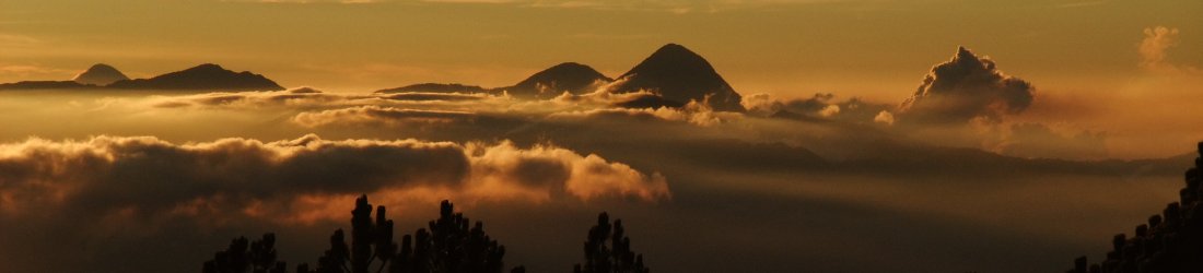
Contrast it with this photo below, posted by the Nepali Times last week under the headline Nepal lockdown proves air quality can be improved. The photo was taken by Nepalese photographer Abhushan Gautam from a place called Chobar, a village on a hillside by the Bagmati River on the southern fringes of the city.
There is actually a gallery of his images in a separate article in the Nepali Times that is well worth looking at. Anyone viewing this gallery never having been to the city can be forgiven for thinking that Kathmandu is a mountain paradise ringed by glittering snow-capped peaks. And it is, but these views are rare nowadays.

I’ve seen a few photos like this, of pristine blue skies, posted by Kathmandu residents over the last few weeks. Most have been of the rather striking Ganesh range to the north. What intrigued me about this one though, was the arrow. That’s supposed to be Everest (8,848m) in the far distance, 165km to ENE.
Can you really see the world’s highest mountain from Kathmandu? I had no idea.
I still wasn’t sure. Mountains can look very different depending on what side you’re looking from. I’ve seen Everest from a few different angles: north (Rongbuk Valley), east (Barun Valley), south (Mera Peak), and west (Gokyo Ri) to name but four.
Nothing looked quite like this, though. Here’s a blurry close up of the image:

Well, I guess it could be the South-East Ridge, with the summit on the left and the South Summit on the right where the ridge becomes steeper.
But where are Nuptse and Lhotse? The view of Everest from this side is usually obscured by the giant wall of rock linking these two mountains, with the summit of Everest just peeping above. Lhotse is the fourth highest mountain in the world and rises to 8,516m. It is joined to Everest by the 7,900m South Col.
Let’s have a look at some more photos. Here’s one I took of Everest, Nuptse and Lhotse from the summit of Gokyo Ri, 24km to the west.

Now we can see that the profile is quite similar. There’s a bit less snow on my photo (taken in May 2009), but actually this mountain could be Everest if we’re looking at the top 300m to 400m, well above the South Col. Nuptse and Lhotse would therefore have to be hidden behind the pointy peak with a white snowcap and band of rock underneath.
But what are these other mountains in the foreground? The article in the Nepali Times describes Everest as being ‘behind Mt Kang Nachugo and Mt Chobutse’. These two peaks lie in the Rolwaling region of Nepal, to the west of the Khumbu (Everest) region. Here’s what they look like on Google Earth, looking towards Everest from Kathmandu.

But there’s another clue. 20km east of Kathmandu is the village of Nagarkot, which has a reputation for being the no.1 tourist destination for getting views of Everest from the Kathmandu Valley. I’ve never been there myself, but plenty of other people have. So what does Everest look like from Nagarkot?
Well, if you go searching for images of the view from Nagarkot, it turns out that most of them are actually of Ganesh, which is a lot closer and more striking. And of course, most of the others are hazy.
But I did find this little video panorama. Although Everest is almost invisible, the mountains either side of it are recognisably the same ones as those in the Nepali Times article.
So, based on the profile of Everest’s South-East Ridge and the surrounding peaks from Nagarkot, the evidence seems to suggest that you can indeed see Everest from Kathmandu.
But things aren’t always what they seem in this strange world we live in now. Here, for example, is a night-time view of the River Liffey in Dublin that I believe needs closer scrutiny.


Brilliant final curtain. We’ll, I’ve always loved irony.
By the way, this time I haven’t needed to google any word. Maybe I’m improving my English!
Oh, no! I had written “well”, not “we’ll”.
Never lower your guard.
As much as I’m surprised -it does appear to be real -but definitely shot from an altitude of 1500m or so.
My rough math and google earth calculations indicate that Takargo would block Lotse almost perfectly.
And the distance and curvature foreshortening and difference in Kang Nachugo and Everest (2100m feet difference) looks about right in the sight line from Chobar.
And Nuptse is lines up as that ridge in the foreground that looks connected to Takargo to the right -or just perfectly blocked
So what you are seeing is the Everest’s SW face at a slight angle from the peak down to almost the south col, and Lotse (being slightly further in distance from the center of the south col than Everest) -just obstructed by the high left shoulder below the peak of Takargo in the foreground.
-after doing the research -I’m am surprised it’s a real pic.
I could investigate this kind of stuff all day long -fascinating.
Mark – no need for speculation – you can easily confirm this on sites such as udeuschle.de or peakfinder.org. Both quickly produce the exact Everest view you show and give a distance of slightly more than 164 km. Amazing. These sites also show you all other mountains in the panorama.
Cheers, Martin
PS: Direct link here: https://www.udeuschle.de/panoramas/panqueryfull.aspx?mode=newstandard&data=lon%3A85.29154%24%24%24lat%3A27.66581%24%24%24alt%3Aauto%24%24%24altcam%3A10%24%24%24hialt%3Atrue%24%24%24resolution%3A200%24%24%24azimut%3A360%24%24%24sweep%3A360%24%24%24leftbound%3A70.30000000000001%24%24%24rightbound%3A82.85000000000001%24%24%24split%3A60%24%24%24splitnr%3A6%24%24%24tilt%3A1.8091666666666661%24%24%24tiltsplit%3Afalse%24%24%24elexagg%3A1.2%24%24%24range%3A300%24%24%24colorcoding%3Atrue%24%24%24colorcodinglimit%3A264%24%24%24title%3AChobar%20%5BFernglas%5D%24%24%24description%3A%24%24%24email%3A%24%24%24language%3Age%24%24%24screenwidth%3A2560%24%24%24screenheight%3A1400
Wow, thank you, Martin. That’s incredible. I had no idea these sites existed.
I’m embarrassed to tell you how long I spent writing and researching this blog post that you’ve just answered with a couple of clicks. On the flip side, I’m now going to spend the next 3 days looking at this amazing website of yours!
Mark- classical research as you have done it is certainly more rewarding and inspiring than using the quick tools of the digital age. Btw, peakfinder is also available as an app and you can download regions for offline usage, so it also helps to identify views while on the mountain.
Martin Kraus, that link is incredible. -that kills any speculation remaining -and also no fun at all…. lol Thank you so much.
One the things about this pic that initially makes it doubtful is how large Everest is being 160km away and 60km further from the 6000m peaks in the foreground, but when you consider the distance from the pic to the 6000m peaks is 75% of the distance to Everest it starts to make mental sense how incredible the relative topographical prominence of Everest can appear from 160km.
It’s just not a very intuitive scale for someone living in the US
Thanks
Haha, that’s OK, Brian – think of Everest as being 525,000 feet away and 348,000 inches in height 😉
HA. Mark -I meant -not intuitive because no mountains in the lower 48 approach the scale or relative prominence of the Himalayas.
Thanks for the imperial translation, but you’d be proud of a yank -I got the metric stuff down tight!
Hello Mark,
thank you for this inspiring article! I just wanted to confirm that it is not unusual to see a peak in about 200-300 km distance when the air is clear. For example, from Grand Ballon ( 1424 m), highest peak of the Vosges (French mountain range next to the German border), you can see up to the highest peak of the Alps, Mont Blanc (4810 m), which is in about 230 km distance. And Mont Blanc is just half the altitude compared to the Everest…. I just like to share one of my photos taken at Grand Ballon: http://www.silberspur.de/Mountains/pan_GrandBallon.jpg.
If you zoom into the very right part of the image, you will find the ice cap of Mont Blanc illuminated by the early morning sun.
I would like to share another fact/observation for people interested in these things. Sometimes, geographical data is not sufficient to anticipate how a panorama looks like. Under special atmospheric conditions (inverse weather when a cold air layer and fog rests down in the valleys) the image can be modified by an optical effect called “mirages” – a kind of Fata Morgana in colder regions.
This can result in a deformation of the mountain shapes seen from a specific point. Sometimes, mountains can be seen that – as calculated based on geographic data alone – should be hidden.
As an example, I would like to share an old panorama photo I took (still on film) in 2003 in the northern Black Forest in Germany:
http://www.silberspur.de/Mountains/pan_SchliffkopfMirages-1.jpg
Some of the mountains seen in this photo are also more than 200 km away from the point of view. I am not sure if this effect can also be observed in Nepal (warmer clime), but it might be interesting for you.
Many thanks to Martin for the link to https://www.udeuschle.de! It really is fun to “travel” around and generate panoramas. Seems it works really well, as I checked for some views that I know from my home area.
Regards,
Peter
Wow, thanks Peter. Mont Blanc or no Mont Blanc, those are amazing photos!
What a great post! Love this kind of thing.
In the zoomed-in version of the picture, I’m pretty certain that’s Ama Dablam in the foreground and to the right. The large hulk of a peak on the left could be Kangtega or Thamserku.
Keep up the good work!
Thanks, glad you like the post!
I don’t think the Khumbu peaks that you mention are visible. See the comments by Brian and Martin above. The Khumbu peaks are all blocked by the much closer 6000m Rolwaling peaks. Even Lhotse is blocked, and that’s a full 1700m higher than Ama Dablam.
Ah yes, you’re right. I was thinking that, given the profile of Everest, the photo was taken from the south. Kathmandu is nearly due west to Everest hence the view of the mountains in the foreground you mention. The shape of those mountains do have a striking similarity to the Khumbu ones I referred to I think.
I have a panoramic picture I took from the Everest View Lodge just outside of Junbesi that you can see here – https://rivercity.travellerspoint.com/56/
Amazing piece. Born and raised in Bhaktapur, I never had chance to see the Mt. Everest either from Nagarkot or other parts of the valley. I was under impression that we will never see the Mt. Everest from KTM valley. Thank you for writing such a nice article that helped me to understand the mountains better than ever.
Mark, as usual, an interesting insight by you. I got so excited by the article when it come out and straightaway goes into Google Earth to plot it. I wish I had read the article in full to determine where the shots were actually taken from. The guesswork is painful LOL. Even with that, its hard to be certain. Mountain being a 3D landform that look different when you try to identify it from different angle.
Martin Kraus, thanks for the link to that amazing website. When you consider the numbers, an 8848 m summit with 6-7k mountains in the foreground 165 km away. Talk about scale.
There is in fact literary evidence that even in the 1950s it was well known that Mt. Everest is visible from some places in the Kathmandu valley, in particular from the area where the zoo is located in Patan. When Ralph Izaard was reporting as a newspaper correspondent the ascent of Everest in 1953, he at one place in his book (p. 293 in his lovely “An Innocent on Everest”, New York 1954) mentions the following: “In the main, however, for some days from May15 onwards all we in Katmandu could do was to report weather conditions. In theory we were in a good position to do this, Everest being within sight from the roof of the hotel, but at that season the heat haze
rising from India obscured the mountain in the mornings and the succession of northwesters bringing low clouds and thunderstorms hid it in the afternoons.” Izaard was staying at the Nepal Hotel which does not exist anymore, but it was located very near to the zoo in Jawalakhel. The extremely useful website (https://www.udeuschle.de) which Martin Kraus has referred to confirms that “in theory” Izaard could indeed see the peak from the roof of his hotel. Gautam’s wonderful photograph leaves no doubt in me that this is also practically possible when the air quality and the weather conditions in Kathmandu are good enough.
Thanks, Dragomir. Great comment. I will keep my eye out for the book. It sounds like a wonderful complement to Coronation Everest.
Wow, I thought I was lucky to see Everest from my tennis court . . .
https://www.facebook.com/tennistrekking/photos/a.244411022269934/693157360728629/
Great article . . .