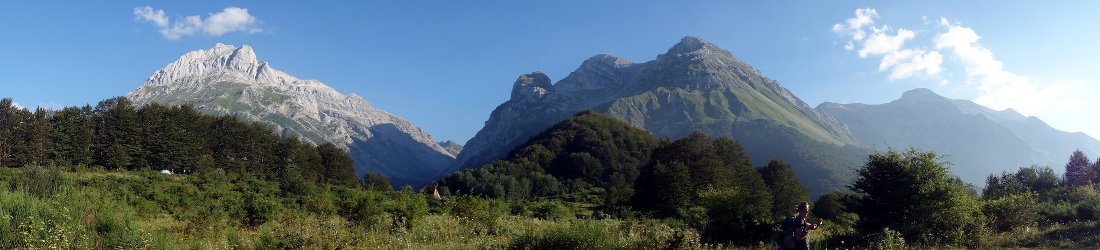

Monti della Laga is one of the forgotten mountain ranges of Italy’s Central Apennines. It shares a national park with the more famous Gran Sasso massif (Parco Nazionale del Gran Sasso e Monti della Laga), but could hardly be more different in character.
The dry rock cathedrals of Gran Sasso are steep and dramatic, and reach their pinnacle on the summit of 2,912m Corno Grande, the highest point in the Apennines by some margin. Meanwhile the peaks of Monti della Laga, just to the north, are rolling and grassy, and full of little streams running through narrow gullies. Last time I went there I remember thinking they would be a great range for wild camping. But unfortunately it is a national park, and camping is forbidden.

Monti della Laga straddles the border of Abruzzo and Lazio, and 2,458m Monte Gorzano, right on the border, is the highest point in Lazio. We reached its summit last July while a thunderstorm was raging to the east. The sky was purple. We were treated to a heavenly light show as forks of lightning flashed across the horizon, but these things are slightly disconcerting when you’re on top of a mountain and you’re keeping your fingers crossed it doesn’t come your way.
A couple of weeks ago Edita returned from her mission to Chad, and we couldn’t wait to get into the Apennines for the first time since October. The weather forecast was patchy in most mountain areas, but Monti della Laga looked the most promising, clear in the morning, but with rain forecast for the afternoon.
Three peaks on Monte Gorzano’s northern side — Pizzo di Sevo (2,419m), Cima Lepri (2,443m) and Pizzo di Moscio (2,411m) — are almost as high, and I traced a route on the map which took us over the summits of the first two.
It was our third visit to Monti della Laga, so we knew what to expect from the mountains, but another factor gave us cause for uncertainty. Both of our peaks rise above the village of Amatrice, which was partially destroyed by a 6.2-magnitude earthquake on 24 August last year. The quake was felt here in Rome, but it struck at 3.30 in the night and I slept through it.
In the Tronto Valley, immediately west of Monti della Laga, many people never woke up. In Amatrice 234 people lost their lives, 11 died in Accumoli near the epicentre, and 49 in Arquata del Tronto, a little to the north.

“Amatrice is not here any more,” its mayor told the media the following morning. “Half of the town is destroyed.”
After our recent experiences in Langtang, we had no wish to drive through another area of earthquake devastation, whatever ghoulish fascination these places may provide. But the route to the start of our walk passed right through Amatrice. Could we even get there, or would the village be closed?
Sure enough, the army were stationed on the road into the village, and they were only allowing residents through. We were turned back and directed to take another route further to the north, through the villages of Saletta, Cossito and San Lorenzo e Flaviano. These villages had suffered too, and many buildings had been reduced to rubble. Coming so soon after our visit to Langtang in Nepal, where we’d seen an entire village buried by a rock avalanche, it was a shock to see the effects of natural disaster so close to home.
We didn’t know it at the time, but the forces of nature were about to curtail our own adventure too, if on a much less cataclysmic scale. As we drove through these shattered villages, I considered it very unlikely there would be anything left of the road I had identified on the map. It criss-crossed the western flanks of Pizzo di Sevo from the village of Sant’Angelo, starting at 1,000m and climbing to 1,530m. But by a miracle the road turned out to be in great condition. There was no sign of earthquake damage and it was tarmacked all the way. There are more potholes in Rome.
At the top of the road there was a long grassy meadow known as Macchie Piane, which I believe translates as Spotted Plains. Pizzo di Sevo rose 900m above patchy forest. It was streaked with snow gullies, but it looked gentle. Against our better instincts we persuaded ourselves that we could find a way between the snow, and could leave our boots and crampons in the car. This was a mistake. There is always more snow than there looks from below.

We set off in trail shoes that were saturated with water by the end of the walk. Of more concern were the short sections of snow that we had to cross. The snow was hard, and it wasn’t easy stamping footsteps. There was never too far to fall before landing in grass, but these sections were an inconvenience which needed extreme care. We could have walked across them easily in our crampons.
Within ten minutes of setting out we were thrilled to see a family of cinghiali (wild boar) on the fringes of the forest. A good path passed between clumps of trees as it zigzagged its way up. The going was easy to begin with, but a sunny morning had clouded over, and behind us we could see dark rain clouds over Monte Terminillo 30km to the west.
The storm was heading our way, and the first spots of rain reached us just as the trail cut across a large snowfield. It looked like we would be able to reach the summit on grass if we diverted up a nearby ridge, so for the remainder of the ascent we climbed off piste, up steep grassy slopes. It was more tiring this way, and it became cooler as the rain continued to fall. Lower down there was not a breath of wind, but at around 2,100m we suddenly found ourselves climbing into a gale.
I’d only had a light breakfast. I realised I was running out of energy, and becoming very cold. I asked Edita if we could stop for a snack. We found a sheltered spot behind a grassy ridge, and put an extra layer on while I gorged myself on the first half of our lunch.

Edita was absolutely fine, but I was starting to shiver, and she noticed.
“We can return to the car if you prefer.”
I choked on my sandwich. “You’re joking? I’ve climbed harder stuff than this. That would be pathetic.”
I think she was trying to hide a smile. She shot off ahead of me for the last 300m of the ascent, as she often does. There were several short snow gullies to cross, but the final section was up a gentle grass slope.
We reached the giant summit cross in a howling gale. It was absolutely freezing. We stayed on top for no more than a minute while we took summit photos. There was no reason to stay any longer.
To the south-east there was a drop of about 200m to a col. We could see Cima Lepri rising up about a kilometre away on the other side. If anything, there was a little more snow, but it looked do-able.
The wind was so strong that I had to shout at the top of my voice.
“Shall we go up the other one, or head back to the car now?”
“Are you mad?” Edita said. “There’s no way. Of course we should go back down.”
For once it was my turn to feel like the tough one, but I didn’t argue with her.

It wasn’t long before we were out of the wind again. It was a quick descent down the grassy slopes, and as we reached about 2,100m it became very calm. A little further down we stopped for the rest of our lunch and our usual Moretti summit beer. The clouds were clearing, and patches of blue sky were appearing all around. All was peaceful, and it was hard to imagine the storm we had experienced on the summit. Things had changed so quickly.
There were other contrasts to this satisfying solitude. Amatrice was directly below us. We couldn’t be certain of its condition from this distance. There were still buildings standing on one side of the village, but the western half looked completely destroyed. Looking across the Trento Valley to our right we could see another village perched on a hillside opposite that had suffered a similar fate. It had been flattened, and it looked like it had slithered down the hill in a landslide. We learned later that this was Accumoli, the village close to the epicentre.
We descended to the car in sunshine, and stayed that evening in the village of Capitignano 20km to the south. The village lay on the eastern side of a broad grassy plain surrounded by forested hills. Here the houses were newer, and in much better condition. They had hardly been touched by the earthquake, and we could have been a world away.

The following day the weather forecast was much less promising, but nevertheless we decided to drive up the Trento Valley and try to access one of Monti della Laga’s northern peaks, 2,073m Macera della Morte — or as we decided to call it, the Butcher of Death.
This turned out to be an appropriate name. We found ourselves driving right through the earthquake zone. All along the road, houses had fallen to the ground. We passed Accumoli and Arquata del Tronto, perched on cliffs above the road. Both looked like mediaeval fortresses that had been razed by an army. On the right-hand side we passed an entire village of prefabricated huts — accommodation for those who had lost their homes.
We had identified Trisungo as a place where we might find a village store and buy sandwiches for lunch. The place was a ghost town. Almost every house was partially destroyed, and the village had been abandoned. We held little hope for Spelonga, the next village up the hillside.
We never even got that far. Beyond Trisungo a barrier had been erected across the road. A sign informed us we were entering a danger zone, and we couldn’t proceed without an escort. I don’t know which other peaks of Monti della Laga are accessible at the moment, but Macera della Morte isn’t one of them.
We drove back to Rome pondering how our lives have been affected by earthquakes over the last two years. Edita was at Everest Base Camp when the 7.8-magnitude quake struck in 2015, the same earthquake we had seen the devastating results of in Langtang in March. The following year she was mountaineering in Ecuador when another 7.8-magnitude earthquake struck. After both these events she remained in the country for two months to help with the humanitarian response for the World Food Programme. Last year she flew from Italy to Chad on 23 August, the day before the earthquake here in the Apennines.
As for me, I experienced my very first earthquake while staying in Umbria last October, a 6.6-magnitude shock which set the pictures swinging on the walls.

Then on 18 January this year, I was working in Rome when four earthquakes ranging between 5.2 and 5.7 struck in a single day. The first was at 10.30, there were two in short succession at around 11.30, and then another at 2.30. The third was powerful enough for us to be asked to evacuate the building. We stood outside in the car park for 20 minutes while engineers inspected the building for damage, then returned to work.
It’s not frightening to experience an earthquake when you know your building is earthquake-proof and that the epicentre will be miles away. The first was gentle, and I didn’t realise it was happening until a colleague mentioned it. I looked up to see the pot plants shaking, as though in a breeze. The second two were much stronger, and unmistakable. They lasted for well over a minute each time.
The fourth was also gentler, but by then I had become an expert at spotting them. I noticed it immediately, before the tremor became intense enough to shake the plants. The initial experience is a bit like feeling drunk. The room starts to sway a little and you feel dizzy, but nothing more. As the tremor increases in intensity, the feeling is very different, and quite weird before it dies away again.
Up in the mountains things must have been a lot more unpleasant. The epicentre for these four quakes was again near Amatrice. It was cold enough for us standing outside in a car park in Rome. In January there would have been metres of snow in the Apennines, with villages difficult to reach.
What do you do? You can’t stay outside in the freezing cold, but would you go indoors if you don’t have the assurance of knowing your building is safe?
I guess you just have to get on with your life, and not spend every moment worrying. Mountains exist where the plates collide, and they are places of beauty. Earthquakes are a constant risk in the Himalayas, but every year I return there, and I will continue to do so. Now I will be thinking of the Apennines in the same way.


I have just “discovered” your blog in my recent search for information on the original Sherpa “Tigers”.
I have now read everything you have posted and hope to also experience your books soon.
I find your the information on your mountain adventures to be informative, insightful, respective and, if you will, reverent.
Your blog from 2013 on the Everest violence I found to have been handled with calming reason. The wife of a man who loves and revers the mountains and the men who work unfailing hard to make Westerners dreams come true, I can’t help but feel that the one slice of the baloney is slightly thicker on the Sherpa’s side.( weird analogy I know but hopefully you get the picture). Some of my husband’s most cherished memories are of his time in the Himalayas’ drinking tea and eating lentils with the porters and Sherpas.
I think and feel it absolutely neccessary to enact stiff regulatory access to Everest. It is not Disney World, and a summit attempt should not be made readily accessible to anyone who can afford the permit. Although you feel the restrictions on Denali might be a bit much, they will ensure the preservation of this North American high peak for generations to come in as close as possible to it’s natural state as pristine wilderness.
I also think the adage of, “Pack it in, pack it out” should be a contegency of the permit and outfitters should be fined and restricted severely if their expeditions do not adhere to that rule. If I may be allowed, and I am quoting here:”A recent report by Grinnell College estimated that 12 tons of feces are left on the mountain each year, either buried in the snow around the four camps near the peak or deposited in rudimentary toilets that are emptied near water supplies further down. An estimated 50 tons of garbage — from broken tent frames to used oxygen canisters to food wrappers — are strewn along the route up the mountain, along with many of the frozen, half-buried corpses of the more than 200 climbers who have perished attempting the ascent. Little wonder the mountain has earned the nickname World’s Highest Garbage Dump.”
Thank you for allowing me to praise and rant.
Keep up the good work and ,”Berg Heil!”
Janet Schwarz
Thank you, Janet. Did you mean to post this comment on a different blog post – if so, which one? It’s a little off-topic for this particular post but could be relevant to a number of other ones. See the commenting guidelines for more info: https://www.markhorrell.com/blog/guidelines/.