
From high Plynlimon’s shaggy side
Three streams in three directions glide
Lewys Glyn Cothi
Many people think of Wales as having two principal mountain ranges: Snowdonia in the north, rising to 1,085m on the summit of Snowdon, and the Brecon Beacons in the south, whose high point is 886m Pen y Fan. But stretching for nearly 80km through the spine of central Wales is a third range, the Cambrian Mountains, that is less well known.
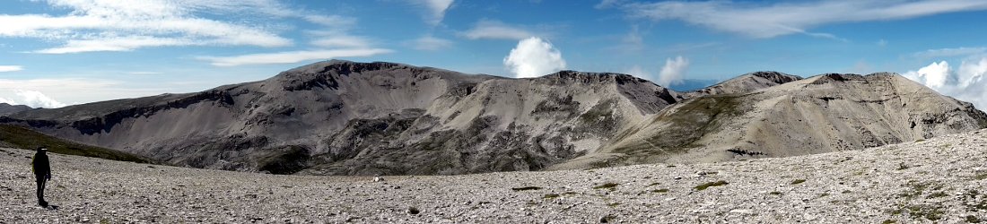
The Cambrians lack the steep, rocky summits of Snowdonia and dramatic escarpments of the Brecon Beacons, but what they lack in drama they make up for in remoteness and solitude, with long views and wild grasslands stretching to the far horizon.

Their highest peak, 752m Plynlimon, is a complex mountain of multiple rolling summits connected by broad ridges. It is the source of Britain’s longest river, the Severn, its fourth longest, the River Wye, described by the 19th century travel writer George Borrow as ‘the most lovely river, probably, which the world can boast of’ (it was a smaller world back then), and a third river, the Rheidol, which flows west into the Irish Sea at Aberystwyth. Borrow visited Plynlimon in 1854, and hired a shepherd to take him to the sources of all three rivers, a visit he described in his book Wild Wales.
You may also see Plynlimon written ‘Pum Lumon’. This is not a misspelling, caused by writing the word in caps with the letters squashed too closely together (a problem people called Clint are acutely aware of), but actually the original Welsh spelling, meaning ‘Five Tops’. Plynlimon, I’m led to understand, is actually an anglicisation and therefore incorrect. Personally, I prefer to use the more memorable anglicisation ‘Plum Lemon’, which I find a bit fruitier.
But I digress. I didn’t know anything at all about Plynlimon until I saw it for the first time while standing atop Mynydd Gwerngraig, an outlying summit of Cadair Idris. I had always thought of Cadair Idris as the southernmost peak in Snowdonia. I was therefore surprised to see more mountains to the south.
Another hillwalker joined me on the summit. ‘That’s Plynlimon, the highest mountain in mid-Wales,’ he said.
That was 2008 and I’ve been meaning to climb it ever since. The Easter weekend was going to be my chance. I was determined to make the most of it and explore the mountain thoroughly. So what was the best route?

Most UK walking guides tend to pick the most popular or the shortest routes to the summits, but there are two notable exceptions for the more intrepid rambler. Over the last few years I’ve done a few multi-day backpacking routes from Graham Uney’s Backpackers Britain series, published by Cicerone guides. The word ‘intrepid’ doesn’t fully describe all of the routes in these guidebooks, however, unless you enjoy completing the last few miles of your hike under the beam of a head torch. ‘Insane’ might be a better description for some of them. These walks often have a sting in the tail. They have even caused me to invent a new word, ‘uneyed’, which means to traipse across the roughest terrain your guidebook writer can find, often passing over a pointless peak right at the end of a very long day.
There is an alternative, however. Vertebrate Publishing have recently reissued Richard Gilbert’s classic walking guide 200 Challenging Walks in Britain and Ireland, a book I remember from my youth. I did some of the Scottish walks in it about 20 years ago.
I have another book by Richard Gilbert called Memorable Munros, a memoir of some of his days backpacking in the mountains of Scotland. The routes in this book suggest that he could not only have challenged Graham Uney, but given Nepalese porters a run for their money when it comes to lugging heavy loads across high mountains (he died in 2018 at the age of 80). Despite its title, however, the routes in 200 Challenging Walks are a bit more do-able for ordinary hikers who haven’t been trained in remote mountain combat by the British Army. While some of them cross over difficult terrain, they are all single-day hikes, that happen to be a bit longer than the walks in your average guidebook.
I glanced at the Plynlimon route in the Backpacker’s Britain guide to Wales. It was a 3-day hike, with days of 29km, 26km and 13km in length. I’ve not been backpacking since Edita’s and my outing to the Mamores and Grey Corries in September 2020, a trip that had an unfortunate conclusion for my rickety old left knee. 29km with a big pack? Hmm…
200 Challenging Walks, however, seemed to offer the perfect alternative. Walk 173 described a thorough exploration of the whole of Plynlimon in the course of a single 31km hike across all 10 summits over 2,000ft in height. Richard Gilbert got the thumbs up. Sorry, Graham.

We decided to warm up for our epic hike by making an ascent of Drygarn Fawr the previous day, the highest point of a sprawling grassy bog call Abergwesyn Common a few miles to the south, which happens to have the world’s largest summit cairn (well, it’s certainly the largest one I’ve ever seen).
When I did a backpacking trip in these hills 14 years ago, I didn’t see a single soul for two whole days, and even spent a night in a bothy, confident that nobody else would show up to ruin my solitude (they didn’t). Drygarn Fawr seems to have become more popular in the years since. As we had our lunch on the summit, there were as many as 12 people up there at various times. I don’t know if this is because the gigantic summit cairn has made the peak ‘Instagrammable’.
Social media has certainly led to changes for hikers. At our campsite the following morning, Edita took offence when I suddenly let rip with a popular two-word exclamation. I had to reassure her that my words weren’t aimed at her, but the instructions on my packet of porridge, which informed me that, while waiting for 4 minutes after pouring the water in, I should take a photo of the product and post it to Instagram, tagging the name of the brand (whose name I won’t repeat here, but I believe their marketing manager is called Clint). I don’t use Instagram myself, but I can say with confidence that there’s enough crap on the internet, and a photo of a cardboard box with a spoon in it, taken inside a tent, is not ‘Instagrammable’.
In fairness to Drygarn Fawr, it does have other assets besides its cairn. As we approached the summit, a proud Welshman built like a front-row forward stopped us to name every feature on the horizon, including the dark outline of the Brecon Beacons to the south.
‘You can see half of Wales from here,’ he said.

It was a bit hazy that day, but the view was certainly impressive, and far more distant than many views in Snowdonia, which are often blocked by other high peaks.
We started our ascent of Plynlimon at 8am on Easter Sunday, from a place called Eisteddfa Gurig on the A44 to Aberystwyth. There is a public car park here, but it’s privately owned and you have to put £5 into an ‘honesty tin’ on a wall outside a farmhouse. Judging by how quickly the owner came out to check we’d put our money in the tin while we were still standing beside our car, she has doubts about the honesty of those who park there. Luckily we had been able to rustle together £5 in loose coins.
A direct trail goes straight up the south side to the top of Plynlimon Fawr, the mountain’s main summit, from the farm at Eisteddfa Gurig. We took a more roundabout route in order to climb Y Garn, Plynlimon’s most westerly peak. There is a farm track up to around 600m, which skirts the eastern edge of a forest to arrive at a radio mast. We continued up to the corner of the forest to join Plynlimon Fawr’s southern ridge.
Here we had to climb over a gate to make a short diversion up to Y Garn along a subsidiary spur. Y Garn is quite a nice viewpoint with three prominent features to draw the eye in different directions. Immediately below us to the west was the dark blue of the Nant-y-moch Reservoir, stretching its arms like a three-pointed star, the shortest one buttressed by a tall dam. On the far horizon to the north, Cadair Idris, the place where I had first set eyes on Plynlimon, was unmistakeable, with its twin summits separated by a long ridge, and lower terrace leading to the third summit of Mynydd Gwerngraig.

More immediately, Plynlimon Fawr lay just a stone’s throw away to the northwest. We had only been walking for an hour, and we were separated from it by the gentle grassy slopes of the south ridge. We retraced out footsteps to the corner of the forest, crossed the gate, and made our way up those gentle slopes. We were approaching the summit only 45 minutes later.
One of Plynlimon’s annoyances are the many wire fences criss-crossing every ridge and summit. Although most of the mountain above 400m is classified as access land, which means it’s publicly accessible, it’s privately owned, either by sheep farmers or foresters. It’s necessary to study the Ordnance Survey map to determine which side of the fence you need to be on at any given summit. In fairness to the guy who put the fences up, at least he didn’t use barbed wire. Many a good walk in Britain has been marred by split trousers, but not here. Occasionally a helpful horizontal post had been added to a fence in strategic locations, making it easier to cross. On the summit of Plynlimon Fawr there was an enormous stepladder stile.
It was windy on top. Two other hikers were nestling inside the summit shelter. They didn’t see us and we passed them without a word, and in contrast to Drygarn Fawr, we wouldn’t see another soul for the next three hours.
The next summit, Plynlimon Fach, lay a short distance to the northwest. I was expecting to cross the summit and see a connecting ridge, but instead we found ourselves confronted by a 100m drop. It seemed a silly exercise to descend all that way only to come back up again, but I had promised myself we would complete every last inch of Richard Gilbert’s walk, so descend we must.

George Borrow would certainly have been able to relate to this. Just below us was a small lake that gives birth to the River Rheidol. It was a steep descent to reach its waters, but Borrow insisted to his guide that he take him there, claiming that ‘it is not only necessary for me to see the sources of the rivers, but to drink of them, in order that in after times I may be able to harangue about them with a tone of confidence and authority’. So if you feel I’m haranguing you with this blog post, I’m merely following literary tradition.
In fact, it was worth the diversion. You won’t see many photos of Plynlimon that make the mountain look distinctive. This is because it’s such a sprawling mass, rising only slightly above the surrounding hills. George Borrow also noted to his guide that ‘it does not look much of a hill’ upon first seeing it. His guide responded by saying they were already on high ground. Some of the best views of Plynlimon are from these subsidiary ridges.
We trudged back up those 100m to Plynlimon Fawr then made our way west, following a fence down to a col then back up to the central summit, crossing peat hags on the way. We were now standing about 30m above the source of the River Wye, which at 250km is Britain’s fourth longest. While not as well known as its big brother the River Severn, it passes through more mountainous country on its journey to the Severn estuary, and is therefore more picturesque.
A dry pond hinted at the unusual conditions. It was mid-April, but the sun was shining brightly. When sheltered from the wind it felt more like a summer’s day than the heart of spring. Equally favourable was the terrain underfoot. The proud Welshman we had met on Drygarn Fawr had described Plynlimon as boggy, but we found only dry conditions and hard earth under the long grass. It undoubtedly made Richard Gilbert’s walk less challenging.

We then had another one of those long diversions down to the ‘summit’ of Pen Cerrig Tewion, which was about 30m lower than the source of the River Wye but on the opposite side of the main ridge.
‘You’re crazy taking us all this way,’ Edita said as we traipsed across rough grassland to a non-descript hummock marked by a cairn.
‘It’s the guidebook’s fault,’ I replied. ‘I agree this is a bit silly.’
But this particular summit yielded the best view we had of Plynlimon’s main summit. Its north face boasted a series of rocky terraces and crags that made it look a bit more like a proper mountain. It had been another worthwhile diversion, but it was a shag trudging back up those grassy tussocks to rejoin the main ridge.
We had now stood on top of at least five summits already (though ‘summit’ would be quite a generous term for some of them). But we still had a few more to do. I don’t know which of them were the ‘Five Tops’ of Plynlimon’s Welsh name, but the next one, Plynlimon Arwytsli would undoubtedly be one of them (‘Arwystli’ being the old mediaeval name of a Welsh region). At 741m it’s the second highest summit and the only one matching Plynlimon Fawr in distinctness.
The ridge here was so broad and gentle that it would be better described as a plateau. There was even evidence of a road along its top. There were also signs that nature is making a comeback after years of being mauled by hill sheep. Here and there tiny pine saplings were trying to gain a foothold on Plynlimon’s highest reaches.

It was windy on top of Plynlimon Arwystli, but instead of seating ourselves inside the austere granite of one of its three summit shelters, we found a green grassy bank on its northern side to sit and have a lunch as we gazed towards Cadair Idris on the far horizon.
We were now at the quiet end of Plynlimon, or so we thought. We descended to a brown, heather-clad plateau of empty grasslands, confident that now we were beyond the two main summits, we had the mountain to ourselves. I was surprised when half an hour later we reached two small pools on the crest of the ridge, and saw three figures standing at a cairn taking photographs. As we approached them, we saw four more figures emerge in the same direction, and then two more.
‘Where the bloody hell are these people coming from?’ I said to Edita. I was so surprised that I could barely reach for my vocabulary. ‘And why are they all here in the middle of nowhere?’
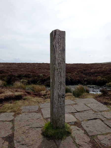
One of our final summits, Plynlimon Cwmbiga, lay in the direction from where they had all emerged. We walked that way and found ourselves on — I’m not kidding — a flagstoned pathway crossing the peat bog. I glanced at the map and a light bulb switched on inside my head. We were on the very end of a long-distance trail known as the Severn Way. A few metres later, a distinctive wooden marker post protruded from a small pool in the heart of the bog. It was the source of the River Severn. These people must be aquatic pilgrims finishing their 354km journey from the Severn estuary.
We left the crowds behind and struck off into the peat bog to find Plynlimon Cwmbiga and our final summit Carnfachbugeilyn. Neither was very distinctive, but both had big cairns.
To complete Richard Gilbert’s walk, we had to descend rough grassy slopes on the west side of the mountain to reach the valley of the Afon Hengwym. The peat bogs on the plateau had been remarkably dry, and it was easy walking, But as we followed the river to its outlet into the Nant-y-moch Reservoir, we were at last squelching through the sort of terrain we had been expecting all along. My trusty approach shoes were reaching the end of their life, with splits in the toes, and I was unable to avoid wet feet.
It had been a beautiful if windy day, but as we reached a tarmacked road beside the reservoir and walked a few miles along it, the skies darkened. There was one last sting in the tail as we crossed the pine forest of Blaen Peithnant to reach our car at Eisteddfa Gurig. This was forestry land; parts of it were already being felled, and fallen trees were across the path. The public footpath marked on the map had been obliterated and it can’t have been used much recently. We soon lost it and found ourselves on a steep hillside, weaving a way through dense forest, with trees barely a metre or two apart. Sharp twigs protruded from trunks at every height. I let out a yell after skewering my thigh on one of them. I had been lucky, and until we left the forest I trod more carefully, fearful of losing an eye or — worse — a testicle.
We eventually emerged onto the same farm track we had ascended to Y Garn first thing in the morning. The final insult was a rainstorm which had been threatening for two hours and eventually broke ten minutes from the end. By the time we reached the car we were soaked to the skin, but I had no regrets. We had actually been very lucky with the conditions and had enjoyed a satisfying day out completing a thorough exploration of one of Britain’s iconic mountains.
For more photos, see my Flickr album of our visit to the Wye Valley hills.


Pingback:A Wild Camp On Plynlimon ( Pumlumon ) - Exit Street View