
This is the second in a trio of posts covering our recent visit to the Isle of Skye and the Northwest Highlands of Scotland. The story began in my first post, The four summits of Sgurr a Mhadaidh.
The weather was looking favourable, but after much deliberation we decided — mainly for logistical reasons — that it wasn’t the moment to attempt the full Cuillin traverse.
Instead, we would continue our Cuillin reconnaissance. But what to reconnoitre? After our traverse of Sgurr a Mhadaidh (see previous post) we had now done all the main technical sections that are likely to confront us on a traverse. There were, however, other parts of the ridge, and the Black Cuillin in general, still to explore.
All of our ascents so far had either started from Sligachan to the north or Glen Brittle to the west. The whole of the east side around Loch Coruisk was unknown to us. This included the very start of the ridge from the seashore, up and over Gars-bheinn to Sgurr nan Eag, the first Munro which many people choose as their starting point.
While it’s possible to reach Loch Coruisk by means of a 3-hour hike from Sligachan, the traditional method is a 45-minute boat ride from Elgol on Skye’s Strathaird peninsula. This means taking the 9am ferry, scrambling over the hills for 7½ hours and catching the last boat back at 5.30.
But Karl our guide had other ideas. He suggested climbing the Dubh Slabs and staying overnight. There is a hut, operated by the Scottish Mountaineering Club (SMC), right at the jetty, but he said it was always booked up months in advance. However, there is a bothy at Camasunary, a short distance away around a headland beneath the modest 497m peak of Sgurr na Stri.
A tingle of excitement ran down my spine. The Dubh Slabs are an iconic feature on the east side of Sgurr Dubh Mor. They form the east ridge of its little brother Sgurr Dubh Beag and descend right to the shores of Loch Coruisk — a kilometre of continuous slanting gabbro ranging in gradient from 30° to 50°. As scrambling goes, it’s regarded as being more or less unique in the British Isles. There are slab sections like it on a few peaks, but nothing as long and continuous.
I knew about them, but never imagined I would ever climb them myself. Now Karl was suggesting the Dubh Slabs as a realistic proposition. It was a golden opportunity and we had to seize it.
My Cicerone guidebook Skye’s Cuillin Ridge Traverse by Adrian Trendall described an 8½-hour ascent of Sgurr Dubh Mor via the Slabs and back down again. As a bonus, it also described a shorter scramble up the southeast buttress of Sgurr na Stri, a famous Cuillin viewpoint. If we followed Karl’s plan of staying overnight at Camasunary, then we could do this shorter route the following day, turning the whole trip into a nice little microadventure.
We had a plan, and it was exciting. Even Karl was excited. But I couldn’t help thinking about that video of Danny MacAskill cycling down the Slabs.
If you’re of a nervous disposition, look away now.
‘That was scary,’ Danny said at the end of the video.
If Danny MacAskill found the Slabs scary, it seemed more than likely that I would shit myself.
The night before our departure, I lay awake reminding myself of a photo in Adrian Trendall’s guidebook of a man posing unroped on a 50° slab. If it was as exposed as this all the way up, then not only would there be a high risk of me leaving a 1km stain of brown, but a somewhat higher risk of creating a human pancake on the shore of the loch.
Edita and I were staying at a cabin in Broadford and had a short drive to Elgol to catch the boat. We arrived by the quayside at 8.45, in good time for the 9.15 ferry with Bella Jane Cruises.
Karl had a slightly tougher journey. He was staying at the campsite in Glen Brittle and intended to walk around the southern tip of the Cuillin ridge to meet us at the other end, a 3-hour walk across rough and largely trackless bogland before even starting up the Slabs.

Meanwhile back in Elgol, four young lads arrived carrying big packs for the traverse. An elderly couple were standing nearby and engaged them in conversation. The golden oldies looked like hikers, but I wasn’t quite prepared for the conversation that followed.
‘You’re doing the traverse are you? We did it ourselves in 1986. It was great fun wasn’t it, Marjorie.’
I listened in awe as grandpa described their ascents of the T-D Gap and Bhasteir Tooth, two of the ridge’s more extreme features that I’m definitely intending to bypass.
We left at 9.15 with 12 passengers and two crew to cross Loch Scavaig, a wide bay dividing the Black Cuillin from the Strathaird Peninsula. The water was choppy; there was a grey mist and drizzle in the air. Aside from the skipper, the other crewman was a young lad who entertained us with stories of the islands — Soay, Rum and Eigg — that we would have seen on the horizon had it not been as murky as tar soup.
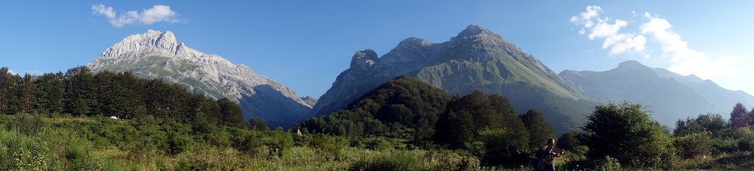
Looking back north to the Skye mainland, things were a little clearer, but not much. The Cuillin ridge itself remained hidden beneath a bank of grey cloud. We were left to guess if the spur we could see leading down from this dark blanket was the Dubh Slabs or a shoulder of Gars-bheinn, the closest peak to the sea (it turned out to be the latter). To the right of this, the triangular silhouette of Sgurr na Stri, fully beneath the cloud ceiling, was now the dominant feature. Our boat headed to the harbour between these two.

Meanwhile to the right of Sgurr na Stri, the mountains parted and a broad plain about a 1km wide reached down to the water. This was the bay at Camasunary where we intended to spend the night. Behind Camsunary was another huge mountain reaching into the cloud: Bla Bheinn, Skye’s other Munro, isolated from the main ridge but still considered a part of the Black Cuillin.
Before manoeuvring the boat into the sheltered harbour beneath Loch Coruisk, the skipper made a diversion to the foot of Sgurr na Stri, where the young lad showed us a feature on the shoreline called the Bad Step. We would need to get across it to reach Camasunary later that evening.
A sloping slab came right down the hillside to the water. He recited a story about shepherds in olden times, guiding their flocks around the hill.
‘But when they came to the Bad Step, the sheep would always refuse to cross,’ he said. ‘What you don’t want to do is follow that grassy ramp up above it, or you’ll get stuck above cliffs with nowhere to go.’

Instead, he pointed out a horizontal crack in the rock a few metres above the sea. It wasn’t what you’d call a path, but it didn’t look too bad.
Despite the sea being choppy, the skipper promised us that it would be calm when we got closer to the shore. Sure enough, the quay at Loch Coruisk is in a sheltered harbour. The Dubh Slabs remained hidden beneath the shoulder of Gars-bheinn. We could see a rushing torrent of water, known as the Mad Burn, spilling down the shoulder into the northern side of the harbour.
A figure in an orange jacket was walking down to meet us. It was 10 o’clock and by a remarkable coincidence, Karl had arrived from his tramp across the moors from Glen Brittle at exactly the same time as us. He’d set off at 6.30 from the campsite. He said that it wasn’t an enjoyable walk. The trail petered out beneath Coir a Ghrunnda and from then on he was roughing it around the base of Gars-bheinn. To cap his frustration, he’d got wet feet crossing the Mad Burn.
I explained that I’d had a sleepless night thinking about a photo in my guidebook.
‘Is it like that all the way up?’ I said, describing the picture. ‘Maybe we can do Gars-bheinn instead.’

‘Ah, you can’t believe those photos,’ Karl said. ‘They always make it look worse than it is. There are only short sections like that. There are plenty of places to stop and rest where it’s not as exposed.’
I was reassured. As the other passengers dispersed we cached our overnight bags behind the SMC hut and walked around the corner to Loch Coruisk. We passed alongside the unusual feature of the Scavaig River. Measuring only about 400m in length, this tiny stretch of water connecting the sea loch of Loch Scavaig that we’d crossed from Elgol with the inland lake of Loch Coruisk is sometimes described as the shortest river in Britain.
There was still a cloudy ceiling overhead, but we were expecting sunshine later. We walked in leisurely fashion across horizontal slabs and boggy grassland on the shores of Loch Coruisk. The drizzle had now stopped and Karl was encouraged: he said that every minute that we took to walk to the base of our climb, the slabs would be drying out.
At last we could see the triangular peak of Sgurr Dubh Beag on the left side of the loch. Behind it, the 944m Munro of Sgurr Dubh Mor was engulfed in cloud, but at only 733m, Sgurr Dubh Beag itself lay entirely beneath. The Slabs formed its right-hand skyline. I breathed a sigh of relief.
‘That looks fine,’ I said. ‘They’re not that steep.’

Of course, they would be a different kettle of fish when I was standing upon them, but for now I was encouraged. It was only at this point, as we stood there surveying the route, that Karl realised we wanted to continue all the way beyond them to the summit of Sgurr Dubh Mor. Despite having walked for three hours to meet us, he agreed without hesitation.
We walked to the base of the Slabs and looked up a grassy gully-cum-chimney. Here we put on helmets and harnesses. It was almost 11.30 by the time we were ready. We stepped up a grassy bank to the foot of the route, but just as we were about to start up the rock, four people with largish packs, two male and two female, stopped at the bottom and looked up at us. It appeared that we had company for the climb and I groaned: I didn’t particularly relish an audience for this bit.
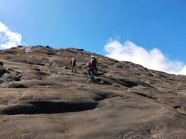
But first, I was in for another surprise. Rather than scrambling up the obvious chimney, as I expected, Karl disappeared around a slab to our left, then climbed up it for about 40m to fix a belay. We started climbing, Edita first and then me on a very short rope behind her. Karl instructed us to traverse to the left until we found a narrow crack about the width of a fist that we could climb up. There were no handholds and we relied on friction alone. The slab sloped like a playground slide and my nerves were becoming shredded at the first hurdle. With nowhere to place my hands and feet but flat against the rock, there seemed to be no alternative but to edge across the slab and hope I didn’t slide.
It felt like a leap of faith. For a brief moment, I almost considered giving up.
‘I can’t do this,’ I said.
My heart was pounding, but I trusted the grip in my hands and the new shoes I’d bought in Portree just the previous afternoon. It was a big relief when I reached the crack. The crack was no more than two inches wide and headed vertically up the slab to where Karl was standing at his belay. It wasn’t much fun to climb either, but at least I had something to grip with my hands.

We were now standing at the place where we would have emerged had we scrambled up the chimney. The question sprung to mind: why didn’t we just go up the chimney instead, with its obvious features, instead of this featureless expanse of slanting rock? But Karl was the guide, so I assumed there must be a reason.
He hinted at the answer a moment later, when he offered us the choice of ascending an easy (‘but boring’) series of steps above the chimney or heading back onto the slab for more of the same. Did some people actually prefer the slab? More surprising still, did Karl think we looked like people who might?
The question was a no-brainer.
‘Easy but boring,’ I said. Why risk life and limb when you can just walk up?
‘Let’s do the slab,’ Edita said.
An argument followed, during which I recall using the phrase ‘it’s not a pissing contest’ several times. It was resolved when Karl suggested we climb in parallel, Edita on the left, out on the slab, and me on the easy bit to the right with a rope stretched between us.

We proceeded in this fashion for another 10 or 20 metres. Then we arrived at the bottom of a wall rising to our right. This, I learned later, was the crux of the climb — in fact, the only really tricky bit of climbing on the whole route. But tricky is relative. This crux section is graded moderate, the same grade as the Inaccessible Pinnacle. To climbers, this translates as ‘a piece of piss’, while to hikers like me, it’s more like ‘a pile of shit’. We skirted to the left on some narrow ledges then climbed up a large convex slab using friction alone. I have to confess that I cheated at one point, giving a little tug on the rope that Karl was holding above me.
No sooner was I above the crux than the group of four emerged below us, having come up in a fraction of the time we had. Of course, they must have scrambled up the chimney like any sensible person, instead of inching up the slabs like we had. The requirement to indulge in cheerful conversation in this exposed location had me flustered, and I was a bit grumpy with them.
We crossed a small plateau about 50m across then reached another short climbing section. It wasn’t super difficult, but I probably took longer than I needed to. To be honest, I wasn’t too keen about having the group of four waiting below and watching my every move. I murmured something about allowing them past because I ‘didn’t need an audience’.
‘It’s OK, we’re not watching you,’ one of them said politely. ‘We’re too busy watching our own moves.’ Which was nice of her.

We let them past, but once we were on the Slabs, we were as quick as they were, and we leapfrogged each other several times.
I really enjoyed the rest of the ascent. It was more of a walk up steep terrain than a climb, with many possible routes across the jigsaw of slabs and ledges. And it was like nowhere I had been before. It wasn’t relentless. As Karl had promised, there were plenty of places to stop, rest, drink water, and get a break from the exposure. And there was nothing like the scary photo in the book — at least, not that you had to climb.
Meanwhile, the sun had emerged and the coastal location meant that the view was hard to match. Loch Coruisk has become an inland band of blue far beneath us. Across its waters, the ribbed dinosaur back of Bla Bheinn emerged behind the grassier streak of Sgurr Hain, while to the right we looked across the wide bay of Loch Scavaig that we’d crossed by boat earlier in the morning.
We sat on a large horizontal slab and had a sandwich as we surveyed the scene, resting our backs against a vertical wall. We had overtaken the group of four by then, and they passed us again as we ate.
‘This is a dream come true,’ said one of the women.

We overtook them for a second time when they stopped for snacks of their own, and we raced ahead. Just below the summit of Sgurr Dubh Beag there was another big steep slab that we had to ascend by means of a narrow crack. Karl climbed up to belay us again. This one was a little easier than the one at the start of our ascent and didn’t feel quite as exposed. Or perhaps I was just becoming used to it.
We reached the summit of Sgurr Dubh Beag and the top of the Dubh Slabs at 2.30. I was elated; it felt like a great achievement. We paused only for summit pics with Sgurr Dubh Mor behind and descended down the other side.
It’s an abseil off the far side of Sgurr Dubh Beag, and we were conscious of the other group behind us, who would have to wait for us to descend. I didn’t mind being watched this time, however, I thought to myself. I might struggle with my climbing, but abseiling is no problem, as easy as climbing down a ladder.
But unbeknown to me, I was about to make a total arse of myself.
Karl scrambled down 5m to a large rock festooned with slings. He rigged up an elaborate belay system that I’d never seen used before, and it took some getting used to.

The normal technique is to attach your harness to the rope by means of a belay device, and slide down the rope with one hand gripped above the device and one below. But for some reason only a mountain guide can explain, Karl decided to attach a short sling between harness and belay device. This meant the belay device was some way above our heads as we descended, instead of at waist level as it normally is.
Karl descended first. We could see him land on a ledge about 10m below us, before disappearing again over the edge and out of sight. Edita struggled down behind him. With her abseil device dangling high above her head, the temptation to reach up and grip the rope above it, like she normally would, was strong.
‘Keep both hands below your abseil device,’ Karl kept barking at her from below. ‘Stop trying to reach above with your left hand.’
I took note of these instructions when it was my turn to follow. I descended the first section quickly and arrived at the ledge. I jumped a few metres down the second section, but stopped when I realised I was about to shoot over an overhang.
‘What do I do now?’ I shouted down to Karl, waiting a few metres below me.
‘Bring your knees up to your chest,’ he said.
‘But where do I put my feet?’
Several confusing instructions followed and I hung in mid air while Karl patiently repeated them.
‘I don’t understand.’

I stood horizontally for heaven knows how long with my feet against the rock. Continents collided and mountain ranges formed. Gradually Karl’s calming words found a way through the layer of sawdust wrapped around my brain, and I understood that I didn’t have to put my feet on the rock at all. All I had to do was bend my knees, tuck my legs beneath me and slide down the rope like a fireman sliding down his pole. Descending became a breeze.
‘I didn’t know you could do that!’
‘There, you see. It’s easy,’ Karl said.
‘You’re telling me.’
Karl and Edita were laughing at me as I unclipped myself from the rope and walked over to where they were standing, excitement in my voice. ‘I’ve learned something today. I’ve learned how to do an overhanging abseil.’
Karl retrieved his rope by means of arcane magic. While I had been waiting to abseil, I noted how the rope was connected at the top and concluded that he would have to ask the other team to disconnect it for him. But all he did was pull on one end and the whole rope pulled through, landing at his feet like a python returning to a snake charmer’s basket. I’ve been climbing with guides a few times and I’m not any closer to understanding any of their rope wizardry.
There was a bit more down-climbing to do, We roped together to descend the final section to the col between Sgurr Dubhs Beag and Mor then started ascending slabs again.

From the route description in my guidebook, I was expecting the ascent to the summit of Sgurr Dubh Mor to involve yet more technical scrambling, but Karl picked a route that kept below the ridge on its left-hand side. We ascended a series of grassy ledges and eventually emerged onto the ridge just a short distance beneath the summit.
The top of 944m Sgurr Dubh Mor is a narrow blade of black rock. I was initially confused by another peak a short distance away that looked a little higher. But this was Sgurr Dubh an Da Bheinn. It’s 6m lower and not classed as either a Munro or a Munro Top. Until recently it wasn’t even marked on the 1:25,000 OS map — you had to look carefully at the contours to realise it was there. I’d only ever been here in mist and I’d forgotten about its existence.
In 2018, Sgurr Dubh Mor became my first repeat Munro when we climbed it with our guide Andy. Today it became the first Munro that I’d climbed three times. The sky was absolutely clear now; it was a good opportunity to survey a skyline I’d not seen previously.
Aside from Bla Bheinn, which sits apart, divided by two valleys, Sgurr Dubh Mor is the only one of the Skye Munros not directly on the main Cuillin ridge (though some might argue Sgurr Alasdair is another). This provides it with an unobstructed view of all the main peaks on the southern part of the ridge.

To the south, Gars-bheinn and Sgurr nan Eag were joined by a narrow crest of gentle gradients. The distinctive box shape of Caisteal a Garbh-Choire rose in the col between Sgurr nan Eag and Sgurr Dubh an Da Bheinn. Meanwhile the peaks to the north appeared as two separate skylines divided by a deep valley, rather than a single ridge. In the foreground, Sgurr Alasdair and Sgurr MhicChoinnich appeared as a dark cathedral of rock with two towers. In the background behind it, Sgurr Dearg, with its fin of protruding rock known as the Inaccessible Pinnacle, was clearly joined to Sgurr na Banachdaich and Sgurr a Ghreadaidh. It was a landscape of rock. All was grey and forbidding, with not a hint of vegetation to give a splash a colour.
As we left the summit, two young women approached wearing neither helmets nor harnesses. It’s something you hardly ever see in the Cuillin. It was how I ascended Sgurr Dubh Mor for the first time with my friend Tony in 2005. I look back now and scratch my head at the scrambling that we managed unroped and unguided that day.
It was 4pm and we still had a long day ahead of us to reach the bothy at Camasunary. It was an awkward scramble down from Sgurr Dubh Mor involving good use of the popular technique of bum sliding. Karl eyed the gully to the left down into An Garbh Choire. He thought that if we could get into it we could descend quite a long way on loose scree. Happily there was a fairly easy drop down into it from the col between Sgurr Dubh Mor and Sgurr Dubh an Da Bheinn.
Once in the gully we descended slowly. The rock was very loose and Edita had a bit of difficulty because of her weaker leg. Karl decided to take us off the rope so that he could lead the way. He was concerned about the time and keen to move more quickly.
We descended a couple of hundred metres on the scree, taking care not to trigger any slides. The descent became easier when we reached a grassy ramp beneath the slabs of Sgurr Dubhs Mor and Beag. We revelled in the soft grass beneath our feet and raced down it. Water dripped off the slabs and we stopped to refill our bottles.

Karl spotted a way off the grassy ramp across a short boulder field into the bottom of the valley. There were traces of path for short sections, but eventually they disappeared and we crossed boggy moorland to reach the shores of Loch Coruisk. Here the terrain became easier and we were able to walk rapidly across the horizontal slabs.
It was 7.30 by the time we reached the stepping stones across Britain’s shortest river, and we still had to get around the headland beneath Sgurr na Stri to Camasunary.
To save time, Karl suggested that we take his pack while he returned to the SMC hut to retrieve our cache. I put his larger pack on my back and my smaller one on my front and I plodded onwards at the pace of an overladen snail. I had to take great care when stepping down, as I couldn’t see my feet. It was a rare insight into the dangers of extreme obesity.
Edita led the way and I clumped along behind. She took a high path over the top of slabs. After a short while we saw Karl below us taking a different route along the shoreline. We met at a boulder field just shy of the Bad Step to readjust our packs with the extra load. We were too lazy to completely repack; mostly we just strapped everything to the back.
I asked if I could finish the rest of my lunch so that I had less to carry, but Karl let out a strangled gasp which indicated that he didn’t like that idea at all.
‘We’ll be at the hut in 20 minutes,’ he said.

I felt embarrassed. He had been patient with us all day, having left at 6.30 this morning from Glen Brittle to reach us. Now sleep was beckoning.
We approached the Bad Step, the three-storey sloping boulder reaching down to the water that we had seen from the boat on our trip across Loch Scavaig. I noticed a path rising steeply up over it. On another day I might have been tempted to take it, but now we had local knowledge.
‘The guy in the boat was absolutely explicit that we shouldn’t go that way,’ I said.
Karl agreed and we kept to the route the boatman had described, along a crack in the boulder. It was easy to begin with, just a ledge in the slab. Then it became a narrow crack sloping down steeply. Between the crack and the slab was a gap like a crevasse that looked right down into the sea. I edged down the rim of the crack, leaning over the crevasse to rest my hands on the slab.
At the bottom there was a step down where a slip could have seen me falling into the gap. Then there was another ledge with a jump down onto a large rock. Between the ledge and the rock was a second man-sized hole above the sea. It was like minding the gap between the platform and the train. Finally we had to duck as we clambered through a cave.
But overall the Bad Step wasn’t as bad as it claimed. Pretty OK Step would have been a better name; there was no need for a rope and we could have done it unguided, but it might be harder climbing up over the gaps in the other direction.

The trail became normal again, but we soon discovered Karl’s 20 minutes to be wildly optimistic. We rounded the headland expecting to see the beach in Camasunary only to be confronted with… another headland. How long was this going to go on?
We weren’t even finished with steep, sloping slabs. Another one emerged from the heather and the trail went straight across it with a big drop below. We were getting used to this by now, but Edita and I tiptoed across, wary of the exposure.
Karl was pushing onwards and I had to raise my pace to keep up. The extra gear was swinging from my pack like a tangle of pendulums and I teetered awkwardly. But at last we rounded the second headland, the mountains gave way and we found ourselves looking across a wide flat cove with a beach almost a kilometre long. It was Camasunary and a bed for the night.
There were three buildings.
Karl turned and pointed to the furthest one, on the opposite side of the cove.
‘That one’s the bothy,’ he said.
‘I knew you were going to say that,’ I sighed.
In fact, we had even further to walk. When we reached the beach a river barred our way, and we had to walk a little way upstream to reach a crossing point at stepping stones. Inevitably, I got my feet wet striding across.

It was busy when we reached the beach. There were nearly a dozen tents pitched in the flat grassland above the sand. We crossed another stream and stopped to fill our now-empty water bottles.
It was still light when we reached the bothy 9.30pm. Would there be room for us?
The door creaked open. Inside, it was more modern than I expected. There were two rooms: a kitchen-cum-dining area with two big tables and benches, and a sleeping area with a wall full of brand new dormitory bunks. There were 10 to 12 people inside, some already asleep and others sitting up finishing their evening coffees.
We were happy to find three available bunks and we unpacked in silence. We whispered as we brewed up coffee and dehydrated meals on our lightweight stove. We finally snuck to our bunks and turned in for sleep at 11pm after an epic day.
The next thing I knew, Edita was prodding me awake. It was light again and she’d noticed that Karl was no longer there.
It was 7.15. We dressed quietly and found him in the kitchen, sitting up straight and leaning against the wall. He turned his head slowly towards us like a tortoise emerging from its shell.

‘Good morning. How did you sleep?’ I said cheerfully.
‘I hardly slept a wink. I’m done,’ he replied.
From leaving the jetty at Loch Coruisk the previous day, Edita and I had walked more or less non-stop for 11½ hours, but after sleeping like a potato I felt quite fresh. Poor Karl, however, had walked over from Glen Brittle. He’d been on the go for 15 hours and had a rather less restful night. And tonight he had to be back in Glen Brittle to meet his next clients for a 2-day Cuillin traverse, an activity that requires the brain to be in good working order. We still had to walk along the coast to Elgol to get back to the car.
It was obvious that asking him to lead another day of scrambling and rope magic, helping a pair of numpties up the southeast buttress of Sgurr na Stri, would amount to cruelty.
But there was an easier option. Over breakfast, one of the other residents at the bothy told us that the previous day he’d found a good trail up to the col between Sgurr na Stri and its neighbour Sgurr Hain. Sgurr na Stri was known to be a classic viewpoint and none of us had been up it. We could leave most of our stuff at the bothy and make a quick dash to the top by the easy walking route before returning to Elgol. I looked across at Karl and he was nodding wearily in resignation.
We left at 9am. Karl was dressed in just a thin fleece and hiking trousers, and wasn’t carrying anything at all. Edita and I had our usual hiking daypacks with waterproofs, sandwiches and water bottles.

‘Are you maybe carrying a bit much?’ Karl said.
‘It’s very light.’
It took us just an hour and a half to reach the summit. We re-crossed the stepping stones we had used the previous evening and found a slightly boggy trail up behind. Karl appeared to lollop along in leisurely fashion, his arms folded across his chest, but I felt myself racing to keep up with him.
The trail became firmer once we reached the col and turned left to follow stonier ground to the summit. It was one of those peaks with multiple tops that all seemed to be of similar height. In days gone by, I might have rushed around to every summit in turn just to be sure I’d been up the highest one. But as I was coming to expect, Karl had another trick up his sleeve.
‘There’s an easier way,’ he said. ‘Give me your water bottle.’
I had a clear plastic half-litre Nalgene bottle in the outer pocket of my backpack. I’d drunk about half of its contents, which, as it turned out, was just the right amount.
Karl held the bottle in his outstretched hand so that the water was level with his eyes and faced each of the other summits in turn.
‘We’re standing on the highest point,’ he announced.

I took the bottle off him and peered through the water myself. Sure enough, the tops of the other summits were just below the waterline.
‘Bloody hell, that’s amazing. Does this work?’
‘Of course it works. Try pointing it over there.’
Karl gestured to the west. It’s not for nothing that Sgurr na Stri is a renowned viewpoint. From Gars-bheinn to Sgurr nan Gillean, but for a little puff of cloud over the In Pinn, we could see the entire Cuillin ridge for the first time on our travels. Sprouting from them like spokes of a wheel were the projecting spurs of the Dubh Slabs that we’d climbed the previous day and Druim nan Ramh that we’d seen from the opposite end when we climbed Sgurr a Mhadaidh. Down below we could see Loch Scavaig and the sheltered harbour where we landed yesterday morning, the snaking S-bend of the Scavaig River, allegedly the shortest in Britain, and the inland haven of Loch Coruisk, the lake that can be considered the Black Cuillin’s volcanic crater. I think even Karl, who may have begrudged it earlier in the morning, was happy that we came here.
I held my bottle up to the more distant summits of the Cuillin ridge. They all rose far above the waterline.
‘Bloody hell, that’s the second thing I’ve learned this trip,’ I said.
The other thing was how to abseil off an overhang. For these two pearls of wisdom alone, the trip would have been worthwhile, even in the thickest fog (though I couldn’t have learned the bottle trick in those conditions).

We raced down the same way and arrived back at the now deserted bothy shortly after noon. I insisted on stopping for a sandwich (‘It’ll give me some energy, and I’ll walk a bit quicker,’ I promised Karl.)
We packed more carefully this time, and everything fitted nicely into our 33-litre day packs. Only my helmet dangled from the outside; though I had to tie my coat around my waist.
The took only 1½ hours to reach Elgol by the path along the coast. The route followed the Skye Trail, a long-distance footpath crossing the spine of the island from south to north. We passed several people with much larger packs than ours.
It was a pleasant trail beneath smaller, grassier peaks, climbing high above the sea. When the first houses of Elgol appeared across fields, we looked behind us for one last view of the Cuillin ridge in all its glory. The peaks were more distant now and clouds were forming above them, but Sgurr na Stri stood proudly beneath them, gazing up in awe.
And so ended our microadventure. All the Munros are done now and the traverse is our next big objective. But there is so much more here to explore. We’d climbed just one Munro that isn’t even on the ridge, but it was a unique experience, possibly the best we’d had in the Skye Cuillin.
You can see all photos from our week in Skye in my Loch Coruisk and Black Cuillin Flickr album.
Day one: Sgurr Dubh Beag (733m), Sgurr Dubh Mor (944m)
Total distance: 12.99km. Total ascent/descent: 1,164m.
View route map and download GPX
Day two: Sgurr na Stri (497m)
Total distance: 13.03km. Total ascent/descent: 739m.
View route map and download GPX
You can read about the next leg of my journey in the third and final post of this series, The Knoydart Three: Ladhar Bheinn, Luinne Bheinn and Meall Buidhe.


Sublime account and photos of a Skye adventure.
Great description – we did the slabs during the sunny days in June this year. We’re also hikers with a bit of scrambling experience and we loved it. A fantastic day for anyone with a head for heights… if the weather’s good!