
I’ve known about the GR20 for over 20 years. On my first visit to Nepal, I returned with an unwieldy hardback in the shape of a chopping-board called Top Treks of the World, that I’d picked up in the Pilgrim’s Book House, Kathmandu. A slim volume of few words but many evocative photographs, it featured 29 classic treks on six continents and tickled the imagination of a would-be traveller returning home from his first Himalayan trek.
The four European treks in the book included the GR20 on the Mediterranean island of Corsica. The 180km high-level route along the spine of Corsica’s pinnacled mountains was described as the toughest long-distance trail in Europe, with miles of scrambling across rocky passes and narrow precipices.
The GR20 slipped to the back of my mind as I focused my travels on peak bagging in the world’s greater ranges. It never slipped out completely, though. I had a notion that long-distance hiking in Europe was something I would enjoy later in life, when the big peaks were behind me.

Well, I guess it’s now ‘later in life’. Apart from a visit to Ladakh last year, Edita and I have confined ourselves to Scotland since the start of the pandemic. While I have no doubt that I will return to the Himalayas someday, it’s time to start exploring our backyard in Europe a bit more.
Every September, Edita has a month’s contract break from her job at WFP. We’d tentatively talked about organising a mountainous long-distance hike somewhere on the continent, but we were both too busy to spend much time planning it, or even agreeing where to go. June was passing by when an ad popped up in Edita’s Facebook feed for a self-guided walk along the GR20. We discussed it for 9 minutes 37 seconds (or thereabouts), checked out the credentials of the advertiser, then agreed to book it.
A self-guided walk sits somewhere along the spectrum between a guided trek and independent travel. You pay an agency to do the planning, such as booking accommodation for a pre-made itinerary, and arranging meals and baggage transfers where possible. You’re given maps and a route description. Otherwise, it’s up to you how you get from A to B each day.
We booked the trip through a UK company called The Natural Adventure, who in turned seemed to have subcontracted most of the logistics to a French company called Corsica Aventure. They booked a range of accommodation, including, tents, rudimentary shepherd’s huts, chalet dormitories and 3-star hotels. They also arranged most of our meals, including breakfast, packed lunch and dinner. Baggage transfers were only available for a handful of overnight stops, as most of our accommodation was away from any road. This meant that we carried medium-sized packs on most days, with sleeping bags and spare clothes, but not tents, mattresses or stove, and no more than one meal.

One unnecessary item I did regret carrying was an oversized child’s lunchbox of the sort my mother used to send me to primary school with every morning. I put the blame for this on Corsica Aventure, the principal provider of organised treks on the GR20. About half the people we met at refuges and campsites along the way seemed to have booked through them. We were all carrying Tupperware lunchboxes.
While delicious bread, cheese and cold meat is available in great profusion across the whole of France, Corsica Aventure have decided that their clients must eat cold rice or pasta, instead of a sandwich like any normal person. These lunches were always stodgy and bland. No effort was put into making them tasty; the only thing that could have made them worse was if the chef had peed in them (though I’m not 100% sure that wouldn’t have made them better). By about the third day of the trek, we could no longer face them and ended up buying extra bread, cheese and saucisson to make lunch edible. Despite this, we continued to carry a box of uneaten rice every day.
Still, if you’re going to ask someone else to arrange your holiday for you, then you have to put up with a few little quirks. Edita sorted out the flights. My only preparation was to buy Paddy Dillon’s Cicerone guidebook and a pair of spanking new rucksacks (a deep purple 40L Osprey Tempest for Edita and a jet black 44L Osprey Talon for me).
I didn’t have time to read much of the guidebook, but I did get as far as the bit about guided walks. Here I came across the following paragraph, which caused a sinking feeling in the pit of my stomach.
In the north, some operators omit the high-level stages between Calinzana and the Refuge de Carozzu, passing through Bonifatu instead. At the southern end, they may not start and finish at Conca, but at Bavella.
Surely not? The traditional start/end points of the GR20 are Calinzana in the north and Conca in the south. But here Paddy was saying that tour operators tend to chop a bit off either end. I looked nervously at our itinerary. Lo and behold, we were starting at Bavella and finishing at Bonifatu. By then our flights and accommodation were booked and there was no going back. I’m not sure why The Natural Adventure do this to their clients, or whether they would have extended the itinerary had we asked. Conca and Calinzana are just as accessible as Bavella and Bonifatu, so it should not pose too many logistical challenges. I’m guessing they try to make the trip more attractive to punters by squeezing the whole thing into a two-week timetable.
My other bad decision was to put Paddy’s guidebook in my transfer baggage to save weight. Corsica Aventure’s route notes were lighter to carry, but they were cursory at best and dangerously misleading at worst. It’s not easy to get lost on the GR20 because there are so many paint marks to guide the way, but there were times when I would have appreciated more knowledge of the trail conditions and terrain. This vacuum would have unfortunate consequences, but more on that later.
The GR20 takes around two weeks to complete, but it’s often walked in two halves. The village of Vizzavona, with its old-fashioned railway station, nestles in forest roughly halfway along. Many people choose to start and finish there, returning another year to finish the trail. The two halves of the GR20 have their own distinct character. The southern half is considered easier, passing along broad, sweeping ridges with views of the Mediterranean to the east. Occasionally the trail drops off the ridge and contours through pine forest, while towards the south it crosses a bare, undulating plateau. The tougher northern half enters deep into the heart of Corsica’s highest peaks, crossing ridge after ridge in a seemingly endless sequence of scrambles across rocky, pathless terrain. Here it reaches its high point of 2,607m on a shoulder of Monte Cinto, Corsica’s highest mountain. We were walking south to north. This meant we would be starting with the so-called easy half.

It was the strangest of starts to the trip. There was nobody to meet us at 10am when we arrived at Ajaccio airport, the birthplace of Napoleon Bonaparte (Ajaccio that is, not the airport). The town lies in the curve of a bay beneath hillsides clad in impenetrable scrubby forests known as maquis — the notorious hideout of bandits that Corsica is famous for. Our instructions were to meet outside the ‘CCI Building’ at 2pm. We jumped on a public bus with our luggage and headed into the centre of town to while away the morning hanging out in cafés and bars.
The CCI Building, we eventually figured out from Google Maps, was the Chamber of Commerce and Industry, an austere building beside the ferry terminal. We thought we were doing a self-guided trip for two people, so we were a bit shocked to find 50 or 60 people milling around outside. We were given our information pack of maps, route directions and bus timetables that it would have been helpful to receive a few weeks earlier, and ushered onto a massive coach. We weren’t the only people surprised to find ourselves in such a big group. It emerged that everyone had booked with different agencies around the globe, and we had all arrived in Ajaccio to discover we were travelling with Corsica Aventure. Happily, we were not all doing the same itinerary, or it would be like the start line of the London Marathon when we arrived at the roadhead to begin the GR20.
We drove for 2½-hours through maquis-clad hills on winding roads that our enormous vehicle seemed destined to get stuck on. I’d had only 3 hours sleep at our airport hotel in Paris, so I nodded off almost immediately. At 5pm, I was woken up by a voice on the tannoy. We had pulled up beside a field that was being used as a makeshift car park. I knew enough French to understand that the road was closed for a mediaeval street party in the next village. We piled out of the coach and spent the next two hours waiting by the roadside. I sat against a wall under the shade of a tree and tried in vain to go back to sleep.

Eventually the road was reopened. We reached our accommodation at 8pm as dusk was falling. I was dismayed to discover that we would be sharing a dark yurt in woodland with 10 other people. It would have been a pleasant place to stay had we not had so many things to do. We still had to pack our rucksacks for the walk the following day. We would now have to do it in a big tent by the light of head torches. The chances seemed high that I would lose something in the darkness. I’d had no opportunity to read our route description before it got loaded onto the bus. I still had no idea where we would be walking the following day.
But before we did all that, we relaxed for a couple of hours over dinner. We sat in a covered al fresco dining area, surrounded by trees. Two friendly staff served a delicious three-course meal almost immediately on arrival. Edita and I sat with four friendly Australians we had met on the bus — Andrew, Alison, Jacqui and Liam — who were also walking the whole GR20. It had been a weird day, but at last our holiday had started.
It was still dark in the yurt when my watch pinged me awake the following morning. This wasn’t ideal. We needed to be ready for a 6.45 breakfast, then a 7.30 lift to the start of the trek. I grabbed enough clothes to creep to the bathroom block in a state of decency (traditionally, this is one sock). The bathroom had a light on a timer. Every few seconds I was plunged into darkness and had to wave my arms around to trigger the motion detector and turn the light back on again.

Next up was the small matter of our packed lunches. These had been handed to us when we got on the bus the previous day. They weren’t actually ‘packed’ in the true sense of the word. They were just a bagful of ingredients from which we were expected to make sandwiches. One item wrapped in foil turned out to be a whole cheese. A huge loaf of crusty bread was bigger than my entire lunch box. I hadn’t thought to bring a bread knife, and it wasn’t easy slicing this with my tiny pocket knife.
I was a teeny bit stressed by the time we got dumped in a car park at the Col de Bavella after a 20-minute drive. It had been a chaotic introduction to self-guided walking. I still hadn’t read our route directions. While the other trekkers crossed the road and started up the trail, I faffed around in the car park, trying to decide which bits of paper I needed to keep to hand.
Luckily, the GR20 is liberally signposted with red and white paint marks on trees and rocks, each one within sight of the last. The received wisdom is that if you haven’t seen one of these paint marks for five minutes then you’re off the trail. To get back on it, just turn around and walk back to the last one.

We were starting our GR20 about 17km from the official starting point at Conca. I looked up to see some impressive granite crags rising up like a cathedral organ above pine trees to our left. These were the Aiguilles de Bavella.
It was a fairly severe start to the trek. The main route descended to the left and skirted beneath the aiguilles (which, as many of you will know, is French for ‘needles’), but our route description headed straight up into their heart. We had barely followed the red and white paint for a hundred metres when the yellow paint marks of the GR20’s first alpine variant veered off and up to the right. We struck off at a good pace, aiming for a gap in the crags that allowed access to the ridge above, and gradually overtook most of the people who had set off before us.
When we reached the ridge, there was some confusion about the route before us. We were looking across a precipitous combe, walled by pine forest clinging to impossibly steep and rocky slopes. Another granite cathedral rose across the other side. Should we turn left and follow the rim of the combe or descend back down and up the other side? The yellow paint marks were faint and not easy to spot. Edita and I chose the rim, but soon our way was barred by a giant rock tower, the Punta di l’Acellu. Meanwhile, all the people we had overtaken on the way up, had gone down to the right to skirt beneath the tower. We followed them down through the forest. We picked up the faint paint marks, but quickly lost them again. We repassed many people, but everyone was struggling to find the trail and taking wrong turns. It felt a bit like the closing credits of the Benny Hill Show.

After another dead end, we climbed up onto a large sloping rock and came to an abrupt halt. A giant via ferrata chain hung down the other side of the rock and a guided Allibert group were making their way down one-by-one. A dozen people were waiting at the top, and there was no option but to wait in line. The chain was in six sections, and at the guide’s insistence, each client was waiting for the person in front to descend all six before following them down. Some of the clients looked nervous and descended backwards, pulling heavily on the chain. When it was Edita and my turn to descend, we discovered that it was easier than it looked. We walked down one behind the other, facing out and using the chain as a handrail without pulling on it. It was the sort of terrain we might easily have walked down in the Black Cuillin without giving it a thought.
Finally, at around 10 o’clock, we raced past the guided group and had the trail to ourselves for the rest of the day. We followed a gently ascending ridge towards the same dramatic rock formation that we’d seen across the col. At its base we reached the highest point of the day at the 1,662m Bocca Pargulu. Pausing only for photos, we plunged to the left into pine forest, descending steeply for several hundred metres to rejoin the main GR20. It was easy walking for the rest of the day as the path weaved through the forest of laricio pines, Corsica’s native conifer that is used to make telegraph poles back home in Britain. Once we were far ahead of the crowds, we stopped for lunch beside some rock pools.
The final part of the day was picturesque in an easier way. We crossed the river and climbed back up the other side of the valley on bare slopes. The afternoon sun was baking our backs and we looked behind us to see the Aiguilles de Bavella from their opposite side.
Our accommodation that day was the most rudimentary of the trek, but also the most characterful. The Bergerie d’Asinau was a collection of stone shepherds’ huts on a grassy, boulder-strewn hillside just above the forest line. We were the first people to arrive at 1pm. I peered into a doorway to find a wizened old lady peering back at me. It was Aline, the owner of the bergerie. She spoke only French, but this was no problem for Edita, who is fluent. She had a mischievous glint in her eye, but she took a liking to Edita and offered us a private hut, normally for three people but she said that we could have it to ourselves. It was very basic, a stone hut with wooden floorboards, but it was dry.

Aline showed us the ‘shower’ which turned out to be a hosepipe draped over a large boulder, with some planks and a curtain erected for privacy. I laughed when I saw it, but we both took advantage of it. We spent the afternoon sleeping and when we woke up there was a party going on. Many of our new friends from the yurtery had arrived and were drinking beer on the picnic tables of a flagstoned terrace outside Aline’s hut. The terrace had a grand view of the Aiguilles we had just crossed. Behind us, the silvery rubble of tomorrow’s peak, Monte Incudine, hailed us in less striking fashion.
At 6.30 a cheerful grey-haired man came out to help Aline with dinner. Everyone assumed he was her husband, and we all laughed when she told us he was her son. Luckily, he wasn’t offended. He produced a bottle of aniseed liqueur; and later, he sold me a bottle of wine in a recycled bottle for €10. I shared the wine with our new friends. We had discovered one of the unexpected blessings of self-guided walking trips. We’d had the day to ourselves, but every evening we could meet up and socialise with people we were coming to know.
We had some difficulty getting out of our hut the following morning. The garden was full of horses, and one had come to peer in the door and say hello. Aline had to shoo it away and let us out. It was windy outside and there was a chill in the air. Those in tents had had rough nights. We sat on the terrace drinking bowls of coffee that went cold almost immediately.
By the time we set off to walk at 8am, the sun had risen above the ridge and it was warm again. There was a steady climb of 700m up to the ridge of Monte Incudine, a rocky triangle that towered above the northern side of the Asinau Valley. The trail was well defined, but climbed steeply over rocks. There were some short slab sections like a mini version of the Dubh Slabs.

We made good time and reached the ridge at Bocca Stazzunova (2,025m) in less than two hours. On the other side we had long views across a bare, rolling plateau, the Plateau du Coscione. The giant summit cross of Monte Incudine was just a stone’s throw away up the ridge to our right, so we decided to make a short diversion and bag the summit. There was an easy path to the left of the ridge but Edita kept to the crest until a gendarme barred our way and we had to scramble back to the right. We reached the 2,134m summit at about 10am. It was blowing a gale, but it was an airy viewpoint on smooth slabs, with huge views north across the plateau to the mountains of the far north.
The walking was easy for the rest of the day. We returned to the Bocca Stazzunova and had lunch in a sheltered alcove in the lee of some giant boulders. After lunch, the path curved gently around the top of a treeless valley before descending to the left to join a road, which we followed to our next overnight stop, the Bergerie I Croci.
It wasn’t yet 1pm when we arrived, which meant that we had time to shower and wash our clothes before our friends from last night started arriving. Once again, most of them tucked into beer and wine. We had a discussion with the Australians about the difference between gites, refuges and bergeries. We would be staying in all three over the next two weeks, and we didn’t know what to expect. Bergerie d’Asinau had been about as basic as it gets. Bergerie I Croci seemed more like a comfortable mountain hut that you find in the Alps. Surely it should be called a refuge?
A young Parisienne woman overheard our conversation, and a few minutes later she came running inside to tell us why it was a bergerie.
‘Look, come outside and see the sheep,’ she said.

The dormitory was noisy and cramped and sleep that night was difficult. The room was full to the rafters. As with all dorms, there was the sound of people sleeping, but we were also right next to the bergerie’s only two toilet cubicles. Throughout the night, people were getting up to walk past, switching on head torches, clanging doors and flushing toilets. At one point, Liam went outside to fix the tin roof that was banging loudly in the wind. I rummaged through my bag to find a pair of ear plugs, and after that I slept soundly enough.
We left Bergerie I Croci at 8 o’clock the following day, and descended through sandy heathland of bracken and juniper that reminded me of the Sussex Downs. Up ahead, a line of hills formed a long ridge, the Arête a Monda, that we would be traversing in the afternoon. It was hot and sunny for most of the morning as we climbed gradually through beech woods. At one point, the trail meandered beside peaceful rock pools, and we leaped across a stream on stepping stones.
We stopped for a snack in a pleasant glade where several other groups were resting. Here I was disappointed to discover my packed lunch was not as substantial as it looked.
‘Wow, that’s a feast,’ I’d said with glee when they’d given me our lunchboxes that morning, then handed me two sandwiches, a cheese and a sausage to go with them.

But my big child’s lunchbox had only a tiny sprinkling of rice and salad in it; the rest was empty. The two sandwiches turned out to be empty baguettes. The extra cheese and sausage was meant be the filling. All of it could have fitted into the lunchboxes with room to spare.
With only a few extra mouthfuls of energy, we continued on. The trail rose above the treeline and we emerged on the left side of the ridge, high above a valley carpeted in dark green maquis. To our right, a narrow blade of rocks lined the crest like the spine of a stegosaurus. We reached the arête at around midday, passing through a gateway in the rocks over to the other side. Suddenly we were gazing down at the glinting turquoise of the Mediterranean Sea on Corsica’s east coast.
For the next two hours the path weaved from left to right of the crest with short sections of scrambling. Across the valley to our left, the bare top of 2,359m Monte Renoso was the dominant feature, its moonlike top rising above an apron of green, reminding me of the peaks of Sirente-Velino in the Italian Apennines.
At about one o’clock, we caught our first sight of the Refuge d’Usciolu tucked within a grassy combe beneath the highest part of the ridge. It took another hour to reach it; we decided to stop for lunch and savour the tranquillity of our mountain perch before rejoining the crowds.

The last part of the trail had a sting in the trail, rising high on convex slabs before dropping to the right of the ridge. Refuge d’Usciolu was in a spectacular location, looking east to the sea like an eagle’s eyrie. The hut was relatively small, but there were various outbuildings for toilet blocks, shower facilities, staff kitchen and even a small shop. Clusters of modest beech trees and maples clung to the hillside and provided shade. Around 100 silver tents perched on wooden platforms and we were happy to claim one after last night’s noisy dorm.
At dinnertime we queued in a narrow alleyway between trees that led to the kitchen, shop and staff accommodation. The staff quarter was tucked away behind a grove of trees, and I imagined it to be luxurious, like the musicians’ field at Glastonbury. We were each given a bowlful of pasta served out of a large pot; it was like a scene from Oliver Twist. Those of us with Corsica Aventure also received six slices of sausage, a hunk of bread and a small pot of tinned fruit. The pasta was dreadful. There were four tinned carrots on top and some sauce at the bottom if you managed to get that far. Most of us didn’t; halfway through dinner Edita rushed off to throw up. She didn’t come back. We found out the following morning that half the people who ate the pasta were sick. I was one of the lucky ones.
Our evening had one further twist. Our tents were raised on platforms with a metal frame and wooden boards. Each platform accommodated two tents. As Edita and I were drifting off to sleep, our platform started rocking.
‘It’s windy tonight, isn’t it,’ I said.
But it wasn’t the wind. Some gentle female groans wafted to our ears, and we realised that the Italian couple sharing our platform — who we guessed to be in their 50s — were having sex.
‘How can they?’ Edita whispered.
She seemed offended, but it really didn’t bother me.
‘As long as they’re not shagging all night, I’m OK with it,’ I said.

The rocking went on for a few more minutes, but it came to an abrupt halt when I started laughing.
We cocked up our route-finding almost immediately when we left camp at 8am the following morning. We followed some other hikers up the hillside behind the refuge only to find they didn’t know where they were going. It’s always better to follow paint marks than people. We eventually climbed high enough to see that everyone else was over to the right. The two men ahead cut across to join them, but Edita and I were so high up that we decided to continue up to the ridge, where we hoped the terrain would be easier.
It turned out to be a mistake. The ground was covered in a gorse-like shrub that concealed boulders. It took a long time to cut back across the ridge and reach the path. By this time all the people who had set off behind us were now ahead, including the Australians. We met them as we rejoined the trail.
‘You went the right way then?’ I said to Andrew.
‘Remember, the tortoise always wins,’ he replied.

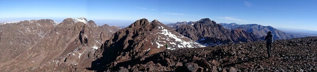
The next hour was magnificent as we trekked along the crest of the ridge on giant granite slabs, overtaking everyone as we raced across the rocks. The trail went across the top of 1,981m Monte Formicula, nominally our second summit of the trek, but really just a high point on the ridge. After about an hour and a half, the ridge started descending to a col. I could see a large mountain looming beyond it. This was Punta della Capella (2,041m), and I realised that we were going to have to descend quite a long way before going back up and over it in the afternoon.
We descended through forest for 300 vertical metres. Halfway down, we were overtaken by a retired Englishman wearing tiny shorts and carrying an equally tiny pack. He walked with us for a while, but he was so quick that I could barely keep up. He told us that he was carrying all his stuff for two weeks, including a tent. He had already completed the GR20 north to south and now he was going back the other way. We’d had glorious weather these last four days, but he told us it was far from glorious the previous week. There was a full-on storm with 100kmh winds. Many people abandoned the GR20 and one man died. Our companion was doing the hard northern half at the time, but he pushed on through.
The col, known as the Bocca de Laporo (1,521m), was a quiet crossroads in the woods. It was the place where the GR20 is crossed by the Corsica Mare a Mare, or coast-to-coast path. We passed at 10.30 and stopped for a snack beside the trail before starting the long ascent.
The energy boost was badly needed. The next three hours were as punishing as it gets, most of it steep, vigorous scrambling over rock steps and boulders. There was frequently no path to speak of; we were simply following paint marks from rock to rock in sweltering heat. Five times the trail rose to a brow and we were fooled into thinking we’d completed the ascent, only to discover another awkward scramble beyond. At one point, at the foot of a dispiriting hillside of rubble known as Punta di Campitellu, Edita sat down on a rock and said she was about to faint. We stopped for a few deep breaths. She remained conscious and a few minutes later she was able to continue.

After more than two hours of strenous scrambling, which felt closer to five, the trail skirted beneath Punta della Capella and we saw the Refuge de Prati below us across a basin. There was more scrambling to come before we reached it. Some rock towers guarded the crest of the ridge; the paint marks took us down some distance to the right before going back up again. The demanding terrain relented just above Prati. Now it was my turn to tell Edita that I really needed to collapse and have something to eat. We sat on golden slopes overlooking the wide hanging valley that led across to the refuge. The ground was littered with sheep droppings, but I was too tired to care.
Like Refuge d’Usciolu, Refuge de Prati enjoyed an eagle-eye view of the east coast of Corsica, but it lay in a more open setting, surrounded by slanting grassy meadows, in pleasant contrast to the rocky terrain leading to it. It wasn’t our ultimate destination though. That lay below us on another col. We passed the refuge at 2.15 and walked across a high plateau before descending over 500m through beech forest. The trail was steep, but it was a relief to get some shade from the relentless blast of the sun. Reinvigorated, we raced down it.
We reached Col de Verde at 3.45, where a metalled road crosses the ridge. I expected it to be busy with day trippers in cars, but it was peaceful — the nicest stop so far, deep in the forest. A Dane called Jakob, whom we had first met on the bus, was having a beer in the canopied garden terrace when we arrived. He said he had set off at 7am and arrived an hour ago. His friend Martin was still feeling ill from last night’s pasta. Both Martin and Edita had suffered today; despite this, the Danes and ourselves seemed to be exactly matched for pace, and we were all much quicker than anyone else. I tried to remind myself that it was a holiday, not a race, but with so many people on the trail I always felt an urgency to get away from everyone.
The accommodation was a series of one-room chalets on a hillside among trees. We shared a 6-bed chalet with a Dutch couple, Ramon and Petra, whom we’d also been meeting every evening. We had plenty of time before dinner to get showered, wash clothes and enjoy a beer on the terrace as the afternoon sun peeped through the trees. Dinner was a true feast that made the pasta at Usciolu feel like a dish of boiled slugs. There was a salad starter, then steak with courgettes for the main course, a cheese plate, rounded off with chocolate mousse. Edita and I shared a half litre pichet of rosé, and Martin even gave me half of his steak. I have fond memories of Col de Verde.

I slept well that night, disturbed only by the occasional rattle of pine cones landing on the roof of our chalet. After one modestly tiring day, things were much easier on the fifth day of our trek. We made a leisurely start and left at 8.15. A wide forest track led downhill into forest before crossing a river and climbing up the other side of the valley on long zigzags. We spent almost the entire day in pine forest, skirting along the side of Monte Renoso, with the hillside to our left. There were occasional glimpses of wooded mountains to our right and a valley below, but for the most part, there were few views as we meandered beneath the forest canopy.
Edita set a punishing pace. It was made harder by the fact that we kept leapfrogging a trio of young Parisien hikers who seemed determined to stay ahead of us. At around 1 o’clock we emerged from the forest and found ourselves looking down on Gite de Capanelle, just 5 minutes below us on a rocky path. We stopped to eat the rest of our lunch, another unappetising rice stodge. To add insult, when we arrived at the gite a few minutes later, the Parisiens — who, it appears, had not booked their trip through Corsica Aventure — were tucking into huge calzone pizzas.
The pizzas looked delicious, but I will not retain many good memories of Capanelle. A ski resort in winter, the gite sat beside a dusty car park. The woods on the hillside above had been cleared for a ski lift, and at the top end another concrete gite overlooked ours like a snooping carbuncle. Both the restaurant and the dorms were cramped. Yet again, there weren’t enough toilet and shower cubicles for the number of guests, though we were early enough to get showered and wash our clothes before the masses arrived.
Instead of having a spacious chalet with six bunk beds like the previous night, we had a tiny room with six bunks at the back of the building. I spent most of the afternoon hemmed within its walls, catching up with my diary. We thought we were going to be in luck and have the place to ourselves, but at 5.30 we were joined by a noisy French party.

The dining room was crowded for dinner and the food was a bit weird: rice and meatballs with no veg or salad. I had very little sleep that night. The room was like a sauna and I lay awake for hours. Each time I drifted off to sleep, I felt one of our roommates waking me up by grabbing my foot. Eventually I had to get up, walk over to his bunk and ask him politely to stop. He left me alone after that, but most of the night had gone.
Fortunately, we were reaching our halfway point and the end of the GR20 South. We had a night in a comfortable hotel room at Vizzavona to look forward to. I didn’t know what to expect, but it had to be better than Capanelle. For the first part of the morning, the trail continued in the same vein as the previous day, contouring a forested mountainside, with occasional glimpses through the trees to the valley below. Today, our glimpses were of the long granite rampart of Monte Renoso rising behind us. At one point, we saw Jakob and Martin sitting among stunted trees at the top of a small rise.
‘Come and look at this,’ they shouted down to us.
It was another sweltering day, and they were both stripped to the waist.
‘Do we have to take our shirts off?’ I said as we joined them.
They had found a magnificent viewpoint beneath an ancient Corsican pine. A high promontory looked across forest to the serrated wall of the Renoso massif. The peak was a gigantic escarpment, reminding me of Monte Sirente. It was Corsica’s crown, rising 2,359m above the maquis in the geographic centre of the island.
‘I’d like to climb that one day,’ I said to Edita.

We took a selfie with our friends the Danes, then continued onwards. The path broke out of the forest and rose gradually on bare slopes of dry grass to reach a high pass, the 1,640m Bocca Palmentu. Here we found ourselves looking across a deep valley to a sharply contrasting peak. The more compact Monte d’Oro looked back at us, its summit an untidy jumble of rocks like the top of a concrete blancmange. At 2,390m, it was a few metres higher than Monte Renoso. Tomorrow we would cross its west shoulder on the GR20, but a plan was forming to return to Corsica and climb some of the island’s summits.
We now had the longest descent of the trek so far, all the way down to the balmy altitude of 900m. We left the pass at 10.30 and plunged back into forest. For once, the terrain underfoot was easy and the gradient gentle. There were moments when we literally ran down the trail. Neither of us were hungry, or even tired; we agreed to skip the flavourless rice in our lunchboxes and treat ourselves to lunch in Vizzavona. Towards the bottom, we reached forest trails. We crossed a black tarmacked road and arrived in the village bang on midday.
Vizzavona lies in a strategic location, where the main road and railway cross the spine of Corsica from east to west. There’s a station, and it’s the place where GR20 North or South trekkers start or finish their walks. I was expecting a busy tourist resort but it felt more like a quiet backwater. A handful of hotels and restaurants were dotted at intervals among the trees and a campsite nestled in the bottom of the valley.
Our hotel, Le Vizzavona, was a grand, pink, three-storied building with red-shuttered windows. It exceeded my expectations by several degrees. The interior felt like a castle and the view from our window, of Monte d’Oro aproned in pine forest, was as good as anywhere I’ve stayed.

We sat in a pleasant, terraced garden for a couple of hours, tucking into steaks and beer while we waited for our companions to arrive. We’d been out of internet access for several days, so we spent the afternoon chilling out in our luxurious hotel room, catching up on news and messages before tucking into a delicious pork rosti in the restaurant.
So far, it had been a somewhat leisurely trek of short days with plenty of time to rest. Accommodation had been comfortable enough, and although the food had been ropey at times, this had been balanced by the refreshing rosé wine every evening that we were not expecting.
We knew that the hardest parts of the GR20 were still to come, but for now we could relax.
To be continued…
If you want to whet your appetite for more, you can see all photos from our trip in my GR20 Flickr album.


Surely there have to be harder treks in Europe than these half day stages with beer all afternoon. More of an excursion for office jocks.
Undoubtedly. I am an office jock, after all, if by that you mean people who work full time at a desk. You can make the trek as hard as you like. The wine definitely made it seem easier, but also more fun. Actually, the short days were more of a cheat. We could have completed it in half the time, then it would have been much harder.