
Glen Spean is a good place “for those who want to hedge their bets with the weather on a trip to the Highlands” starts the relevant chapter of the Walkhighlands guidebook to the Munros. Given that the weather in the Highlands of Scotland is famous for being about as reliable as the latest government COVID-19 guidance, this sounded like a pretty good recommendation.
Glen Spean is a broad, open valley that cuts across Central Scotland from east to west, splitting the Grampian Mountains to the south from the Monadhliath Mountains to the north. It has the benefit of being both highly accessible but relatively quiet from a tourist point of view. The A86 runs all the way along the valley, providing easy access to both the Ben Nevis range and the Cairngorms at either end, hence why Mr and Mrs Webster of Walkhighlands regard it as a good place to hedge your bets.

It so happened that Edita had dropped a pin on a map of Scotland and booked a cottage in Glen Roy for a week. Glen Roy is not a country and western singer, but a quiet valley that joins Glen Spean at the pleasant wooded village of Roy Bridge. In fact, Glen Spean has a profusion of Munros on both the north and south sides of the valley, none of which I’d climbed. For once, the weather forecast was staggeringly good, with clear summits predicted all week. There was no need to hedge our bets; a Munro-bagging extravaganza seemed all but guaranteed.
On the first day, we entered Glen Roy for a warm-up session (so to speak). This involved low-level bog hopping along the River Roy, surrounded by bare, moorland hills. Glen Roy is famous for its Parallel Roads, a series of three parallel lines cut high in the hillsides. These lines look like the remains of ancient man-made route systems, but in fact they’re entirely natural. They have been left behind by glacial lakes that retreated gradually during the last ice age 12,000 years ago, leaving permanent marks at the waterline.
Over the course of the next week, we climbed nine Munros either side of Glen Spean, along with a cheeky tenth down Glen Nevis on the Tuesday. For five successive days the mountaintops were free of cloud, something that has never happened to me in Scotland before.
Here is a brief summary of each hike.
Stob a’Choire Mheadhoin and Stob Coire Easain

On the first day we climbed “the Easains” (1,106m Stob a’Choire Mheadhoin and 1,115m Stob Coire Easain), a pair of neighbouring peaks rising above the western shore of Loch Treig. The peaks are isolated from the surrounding hills by two deep valleys, the one containing Loch Treig and the other, the Lairig Leacach dividing it from the Grey Corries to the west. Later in the week, from the summit plateau of Creag Meagaidh, we could see that the Easains form a distinct twin-peaked mountain, rather like a mini Elbrus.
For this first walk we were joined by Edita’s niece Bernadeta and her partner Mohit, who were climbing their very first Munros. I had warned them of the joys of Scottish bog hopping and the likelihood of crossing trackless wastes on the lower foothills, but they were undeterred. In fact, I was surprised to find a clear path all the way up that was only partly boggy in places.
Our objectives were indistinct and hidden behind their northern shoulder as we set out from the car park at Fersit. Initially, the two Munros on the eastern side of Loch Treig (Chno Dearg and Stob Coire Sgriodain) were much more obvious.

We left our car at 9.15 on a good track that rose gradually to the right of Loch Treig. The skies were blue, the winds light, and we found ourselves entirely alone. But the tranquillity was interrupted by what sounded uncannily like the chug-chug of a train steaming past in woodland to our left. It couldn’t be, but when I checked the map I discovered that it really was. The highland line from Glasgow to Fort William passes along the eastern shore of Loch Treig. A few miles to our south was the famous Corrour Station, a stopping point in the middle of nowhere, inaccessible by road and popular with wild campers.
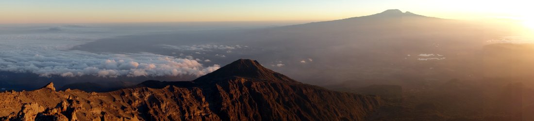
With hindsight, I think this was our most memorable day. The skies were their clearest of the week, rendering the views their most exceptional. From a point quite close to the centre of the Highlands, it felt like we could see their entirety with striking clarity, though in reality we could only see a modest fraction.
Some of this was due the Easains isolation. After rising above Loch Treig in a long zigzag up a grassy hillside that was probably a quagmire earlier in the season but was tolerable dry for us, we were soon able to gauge our surroundings.

Glen Spean is a broad valley with an expansive feel, carpeted with forestry plantations and coloured by the long lake of Loch Laggan at its far end. Opposite us, on its northern side, was a line of rounded, innocuous looking hills. None of them looked very high but I knew that among them were several Munros (in fact, almost all of them were, and we would climb them in the following days).
Above the long zigzag was the Easain’s only steep section, up the shoulder of Meall Cian Dearg, the Easain’s northern ridge. There were some steep sections here, and at one point the trail diverted round a landslide, but it wasn’t quite scrambling.
Once atop Meall Cian Dearg we could see our Munros and the whole of the climb ahead of us. We were on a long, gradually rising plateau peppered with the same quartzite outcrops we had encountered on the Grey Corries last autumn.
Our two summits lay at the far end of the plateau. These were new views to me, and there was a real roof-of-the-world feel to the next part of the ascent. We reached the first summit, Stob a’Choire Mheadhoin, at 12.30. It was an honour to be there with Bernadeta and Mohit on their first Munro, but we didn’t hang around. It was a barren, rocky plateau and we were blasted by the wind.

We dropped down steeply to the col between the two peaks. The backs of my thighs were killing me after months of inactivity, but it was only a 150m drop and climb back up the other side. We reached the top of Stob Coire Easain at 1.15. It was a nicer, more compact summit. We found a pleasant spot on the western side that was sheltered from the wind, and stopped for the rest of our lunch.
We were now looking west to the Grey Corries and down the familiar landscape of Glen Nevis. We could see all the peaks we had climbed the previous September, and could even spy the copse of trees that had sheltered our autumn campsite in the valley far beneath us.
I pointed out Ben Nevis to the others, capped with snow and rising above the dragon back of Aonach Beag. The pyramid of Binnein Beag looked tiny nestling in the centre of Glen Nevis. It was the only peak on the horizon that Edita and I hadn’t climbed, and it was here that we forged our plan for the following day that I related in a previous blog post.
We left the summit at 2 and returned the way we came, down, then back up again to ascend Stob a’Choire Mheadhoin a second time. The descent was straightforward and the path easy to follow, the wide expanse of Glen Spean our constant companion far below. We reached the car park at 5.15.
Carn Liath, Stob Poite Coire Ardair and Creag Meagaidh

The Easains had provided a great introduction to Glen Spean, but its most famous peak was still to come. Creag Meagaidh (1,130m) is a sprawling, star-shaped mountain rising on the valley’s northern side. At its heart is a massive plateau with 5 ridges pointing outwards like the spokes of a wheel. Three of these ridges are tipped with peaks of their own that are high enough, but not distinct enough, to be classified as Munros. To Creag Meagaidh’s northeast, however, is another long plateau containing two more Munros, Carn Liath (1,006m) and Stob Poite Coire Ardair (1,052m). It’s therefore possible to tick off three Munros in a day.
Creag Meagaidh, pronounced Craig McGee, sounds like it could perform a nice duet with Glen Roy, but it’s better known for more strenuous activities. The mountain’s east side forms a giant cliff overlooking the hidden valley of Coire Ardair. The cliff is cut apart by waterfalls that freeze in winter, thus becoming a famous venue for ice climbing (for those who are not worried about bits dropping off as they thaw).
Creag Meagaidh is also a nature reserve. In the last few years the lower end of Coire Ardair has been subject to extensive replanting of native birch and mountain ash, turning the bare Scottish hillsides into pleasant woodland.
Edita and I set out from the car park at Aberarder at 7.45. It’s with good reason that Creag Meagaidh is Glen Spean’s best known peak; this walk certainly had more variety than the other walks we completed that week. It fell into four distinct quarters. The first part, up to Carn Liath on a gentle shoulder of heather-clad moorland, was most enjoyable. The path was good and a big relief after the boggy hell of Binnein Beag.

Halfway up the shoulder, we could look to our left up the secret valley of Coire Ardair to the famous east face of Creag Meagaidh. To its northern side a narrow gap formed a distinctive V-shape in the hillside. This gap, known as The Window, would be our escape route into Coire Ardair after descending from Creag Meagaidh.
We made good time as the heather gave way to soft grass, and then to rubble. Carn Liath is the high point at the eastern end of a broad 6km ridge. We reached it at 10am. It was blowing a gale up there, but the summit cairn was 5 feet tall and big enough to shelter behind. There was a marked contrast between the pretty, forested Glen Spean to the south, with Loch Laggan lapping its base, and the featureless hazy moorland to the north, devoid of summits and plastered with wind farms.
The second part of the walk between the two Munros of Carn Liath and Stob Poite Coire Ardair had looked the most inviting when I looked at it on the map the previous evening. It was a long ridge; most of the world’s best walks are along ridges, because you get long views in both directions.
This, however, was not one of the world’s great ridges. It was too broad to allow us to look down into Coire Ardair to the south, and beyond Coire Ardair an eastern arm of Creag Meagaidh blocked the view into Glen Spean. Meanwhile to the north, I wasn’t enjoying the hazy view of wind farms.
The sun peeped through the clouds but we were buffeted by the wind and it was far from warm. I was lucky to be there, and I knew the weather could be far worse, but I was a bit bored.

There were many gentle ups and downs and a few false summits before we reached Stob Poite Coire Ardair. The final section followed a long flat plateau beside a line of rusty fence posts. The cairn on Carn Liath had been a masterpiece, but far less effort had been put into building the one on Stob Poite Coire Ardair. It looked like a wheelbarrow of rocks had tipped up, spilling its contents, and someone had just left it there.
But things improved after that. Part 3 of the hike made up for the long boring ridge. We dropped down to The Window where we stopped for lunch and watched an avalanche plunge off a northern gully of Creag Meagaidh as the afternoon sun melted the remnants of the winter snow. The bleakness of the wind farms to the north had been replaced by the upper reaches of Glen Roy, and from our vantage point we could even identify the familiar Parallel Roads.
We had a shock as we left our lunch stop. We looked into The Window and could see the crack clogged with deep snow. What would it be like beneath the lip down into Coire Ardair? Without axes or crampons, we were not equipped for a winter descent, and a return along the boredom of the 6km ridge was not an enticing prospect.
We left The Window at midday and walked slowly up Creag Meagaidh and across its boggy plateau, rendered more boggy by snow-melt. Many winter snow fields still remained.

On the way, we passed the most elaborate false summit cairn I’ve ever seen, a giant 2m structure resembling an ancient iron age burial mound topped with a spire. Whoever took the trouble to build it must have felt silly when they realised it wasn’t the true summit.
We reached the summit of Creag Meagaidh at 1 o’clock where, strangely, it was less windy. We had lunch beside the summit cairn. It was an impressive spot, the size of a football pitch. The Easains were prominent to the south, and it was here they reminded me of Elbrus.
Our descent from The Window was an anticlimax. It was fun wading through soft snow in June, but it wasn’t the winter epic I’d been dreading, though we had to take care. The snow was about half a metre deep. It wasn’t slippery but a fall would send us sliding down several metres onto jagged rocks. We stamped big steps and made sure we stayed on our feet.
After about 50m, we reached solid ground and relaxed. All that remained was a knee-jarring descent into pleasant Coire Ardair. We stopped for an apple on a bench with a view and a half, looking across a lochan to the east face of Creag Meagaidh. A site for sore eyes for any ice climber no doubt. They are welcome.
The final quarter of the walk through Coire Ardair reminded me of a Himalayan valley, watered by snow-melt and curving round into birch woods. I was quite tired by then. My knee had locked on Binnein Beag and I was wary of it happening again, but it was an easy plod down to Loch Laggan and the forested floor of Glen Spean. We reached the car, exhilarated, at 4.15.
Beinn a’Chaorainn and Beinn Teallach

As things transpired, we had done Glen Spean’s more inviting peaks. Those that remained were for the connoisseurs. Or more accurately, the die hards: trackless slogs up grassy hillsides, with bog and heather underfoot.
Beinn Teallach is as innocuous a Munro as you will find, in contrast to its namesake An Teallach, which is regarded as one of the finest mountains in Scotland. Weighing in at a lowly 915m, it wasn’t even considered a Munro until 1984. It used to be one of Scotland’s highest Corbetts until it was reclassified. Now it’s one of the lowest Munros, but this doesn’t make it any easier to climb. Unlike the Easains, which are divided by a 150m col, Beinn Teallach is separated from its higher neighbour 1,052m Beinn a’Chaorainn (a name that’s easiest to pronounce while coughing) by a 300m divide. This meant that knocking them both off together would require as much ascent as the Easains.
We left our car beside the roadside at 7.45. I could try to make our ascents of these two peaks sound exciting, or in some way enriching to the soul in the absence of excitement. But that would be like pretending the King James Bible is a good read. So I will keep to the bare facts.
Beinn Teallach and Beinn a’Chaorainn are two grassy mounds separated, as I’ve mentioned, by a grassy valley 300m deep. To reach them you have to pass through a stretch of pine forest, which had been recently forested when we passed through, so wasn’t even a forest, but a field of tree stumps.

To reach the summit of Beinn a’Chaorainn you have to climb a grassy hillside for about 700m. The hillside is angled in such a way that for most of the ascent you can only see a grassy horizon 100m above you that moves further away as you approach it. Eventually the horizon gets bored and stops moving. You reach a pile of rocks that marks the south summit and think ‘thank god for that’.
It would be churlish to pretend that the summit isn’t worth reaching after all the tedium of the ascent. In fact, the summit of Beinn a’Chaorainn is a high point, figuratively as well as literally. It’s actually not bad and quite a surprise given the nature of the climbing thus far.
We were on the southern tip of a W-shaped escarpment, with the three domed summits of Beinn a’Chaorainn forming the tips of the W, divided by deep corries on the eastern side. To the west, the long ridge of Beinn Teallach was 100m below us on the other side of a deep valley, a valley we would have to cross. Across a void to the east we could see the ridges and plateau of Creag Meagaidh, where we’d stood the previous afternoon.
We crossed the three summits, the second being the highest, but it was too windy to stop. If we were in danger of getting carried away by the excitement of it all, our descent to the valley between the two peaks brought us down to earth (don’t you just love it when idioms collide brutally with the literal truth).
There was no path, just a steep descent down — you guessed it — a giant grassy hillside, for 700m. If somebody had rolled a cheese down here, the whole population of Gloucestershire could have chased after it.

The point in the valley that we were aiming for was labelled on the map as Tom Mor. This made me think of Sir Tom Moore, the 99-year-old army captain who had raised £32m for the NHS by walking 100 lengths of his garden during lockdown. As I tumbled down the hillside, I wondered vaguely whether we’d find a kindly old man down there wheeling a zimmer frame. It would have enlivened the walk if we had, but I wasn’t surprised when we reached it to find only a pile of stones surrounded by boggy grass.
Our second peak, Beinn Teallach, lay ahead of us. To reach its summit we had to go back up — yep — a grassy, pathless hillside. Happily, after only 100m of ascent we reached a ridge, and from there the going was easier. There was even a semblance of a path and some rocky outcrops to make our hearts beat faster.
It was along this stretch that we experienced our only rain of the week. We were so surprised by it that we stopped to put on rain coats, waterproof trousers and rain covers for our backpacks. If only I’d brought an umbrella as well. We’d barely started walking again when the rain abruptly stopped. This is known as Sod’s Law but I can tell you that in Scottish mountains it’s a ploy that often works.
We reached the summits at 12.30. The first was slightly higher. Clouds were obscuring the summit of Beinn a’Chaorainn now, but at 915m, we were still beneath them.
The sun broke through as we descended a tedious expanse of heather-clad moorland to reach a path in the valley. We forded a river and walked back along the forest track (or more accurately, ex-forest track) to our car, which we reached at 3 o’clock. It had been good exercise and two more ticks in the box, but these were not Scotland’s finest mountains by any stretch, any more than George Galloway is Scotland’s finest export. This may explain why we hadn’t seen a single other person all day.
Stob Coire Sgriodain and Chno Dearg

We had one final day before we could consider Glen Spean done. We still had to ascend the two Munros on the east side of Loch Treig that we’d seen from the Easains on our first day. These two hills are quite different in character. The higher one, Chno Dearg (1,046m) is a gentle, rounded hillock set in characterless moorland. The other, Stob Coire Sgriodain (976m) is a little more rocky and intricate, with the additional benefit of looking across the loch to the Easains and beyond.
The main benefit of climbing Beinn Teallach and Beinn a’Chaorainn the previous day was to make these two Munros seem better. They are better, but not by much. Both of them suffer from the all-too-common curse of lacking any meaningful path up them, turning their ascent into a rough slog. Of course, a path would make the peaks more popular, thus annoying those purists who believe Britain’s hills should be reserved for those of us who know how to use a map and compass (but then again, why not annoy them?)
Nevertheless, path or no path, it had to be done, and to this end we found ourselves back at the car park at Fersit at 7.45 the following morning. It was a familiar place now after our ascent of the Easains. We crossed the river and railway line and passed through a gate into a tiny village of some half a dozen houses set among woodland.
At the far end we passed through a farmyard into open moorland. Our first option of turning right past a cattle shed was thwarted by a herd of frisky bullocks. We decided not to tempt their curiosity and walked a little further, turning off the track at a signpost to the fabled Corrour Station.
Actually, I’m not being entirely truthful about the path (or lack of it). To reach the summit of Stob Coire Sgriodain, we had to climb a rough old rocky nose that formed its northern ridge. To reach the nose, we had to slog our way up steep, tussocky bogland. After a short distance, we were relieved to stumble across a narrow path which we decided to follow as far as we could.

Which was too far, as things transpired, for the path had no intention of taking us up the nose, but to the col between the two summits. By the time we realised our mistake, we were some way to the left of the nose and looking up its side (or as some might say, its left nostril).
I could hear the purists laughing at me. ‘Don’t follow the path, you daft bugger. Use your common sense. You need to be self-sufficient.’
We scrambled some distance across rough heather to reach a grassy gully slanting between rocky outcrops that appeared to offer a route up the mountain. It did, and after 100m of steep trudging we emerged onto a flattish boggy plateau about 150m beneath the summit. We had managed to avoid the steep part of the nose and were now on the main ridge.
Screw you, purists. You can stick your map and compass up your… I was interrupted as my foot disappeared into a wet hole, one of the hazards of boggy plateaus. I extracted it and squidged forwards before Edita had a chance to turn around and laugh like the chap in my favourite ever YouTube clip.
Thankfully, for the next hour or so, the walk was firmer and a good deal more enjoyable. We reached the top at 10.15. It was a nice summit with views across Loch Treig directly beneath us to the two Easains. On the other side, Chno Dearg was a non-descript mound, though noticeably higher than we were.

We stopped for a sandwich in the shelter of a rock looking towards Chno Dearg. I really enjoyed the next section, traversing down to the col between the two peaks on a clear path that was a blessed relief after the rough ascent. We passed over various rocky summits divided by pleasant sections of short grass.
This enjoyable walking lasted as far as the col. From there, the ascent to Chno Dearg was gentle and grassy. We followed a vehicle track to begin with, which tells you something about the terrain down into Glen Spean. We were 700m above the glen, but somehow somebody had been able to drive up here. Hopefully not Clarkson.
The vehicle hadn’t made it to the summit, but it probably could have done. Eventually we had to leave its tracks and take a direct route up to Chno Dearg’s boulder-strewn plateau. The large summit cairn, big enough to stand on, was at the eastern end.
In keeping with all the other summits we had reached that week, it was windy but clear. Chno Dearg’s monotony was tempered by a fine view across Glen Spean and its forestry plantations. We stopped for lunch just below summit with views of most of the Munros we’d climbed that week.
The less said about our descent the better. Imagine descending 800m of wet peat. That’s about all you need to know. We could see the farm buildings at Fersit for the entire journey. It was a relief to reach them, where firmer ground took us back to the car, which we reached at 2pm.
We’d had a successful week in peak-bagging terms. We’d climbed all nine Munros at the western end of Glen Spean in a series of four day-hikes, and thrown in an extra ascent in Glen Nevis for good measure. We had hardly seen a soul on any of them. I can recommend Creag Meagaidh and the Easains to anyone, peak bagger or not; the others are for those of you with a dislike of paths and love of wet grass.
You can see all the photos from our week in my Glen Spean and Glen Nevis Flickr album.


Thoroughly enjoyed reading of your days in the hills. I have climbed these hills too and found them to be boggy boggy and boggier, Although we had lovely blue skies which made the climbing great with the best views.