
My little trip to the Mafinga Hills which I reported on last week, to identify and climb the highest point in Zambia, was interesting for its exploratory nature, but it wasn’t the most enjoyable peak I’ve ever climbed. Two days later I had travelled the length of Malawi to climb its highest mountain, Mulanje, in the far south of the country, and this was in a different league. Not only does Mulanje contain some of the loveliest trekking you will find anywhere, but to climb its highest point, 3002m Sapitwa Peak, involves a very unusual scramble indeed.

Mulanje is a special sort of mountain known as an inselberg or monadnock – an isolated peak rising like an island above its surrounding plain. More accurately it is a group of over 20 peaks rising from a high plateau averaging around 2000m in altitude. Many of its peaks are split by a series of steep, forested river valleys, and its lush landscape contains plant life not found anywhere else. The most famous of these is the Mulanje cedar, an endemic evergreen tree which has become critically endangered due to over-harvesting and its inability to compete with other trees. Perhaps the most distinctive are the vellozia splendens, man-sized shrubs containing a small trunk crowned by a shaggy haircut of spiked leaves. They are Mulanje’s equivalent of the giant groundsel and giant lobelias found in other mountainous areas of Africa, or the frailejones plants of the Andes. They sprout from the cracks of otherwise bare rock slabs, and more than once we found ourselves grabbing onto them for support during a steep descent, leaving us with sticky fingers from a rubber-like substance oozing from their pores.
Mulanje is known for its thick mist and storms which sweep across while the rest of the country is bathed in sunshine. There are a number of stories and legends connected with it. Much of the landscape of The Hobbit and Lord of the Rings is said to have been inspired by it, although it’s unclear whether JRR Tolkien ever visited the mountain. Various legendary creatures are believed to live there, including a flying serpent called Napolo who floats around creating the misty conditions that envelop its upper reaches, schizophrenic mountain spirits who leave bananas and other tasty meals on the summits to help out weary travellers, though they kidnap those who refuse their offerings, and a kindly old woman who sits by a waterfall blessing new born infants with long life in return for food. As far as I know it does not have a population of yetis.

Sapitwa translates as unreachable in the local Chichewa language, but Mulanje is well set up for trekking with a network of trails and comfortable mountain huts maintained and managed by the Mountain Club of Malawi, and various local operators provide guide and porter services. Through our agency Small Steps Adventure Tours we hired a guide, a cook and a porter from Mulanje Outdoor Adventures (MOA) to lead us up Sapitwa Peak and its neighbour 2896m West Peak.
At the start of our Mafinga Hills climb a couple of days earlier Edita told our guides we had both climbed Everest, an action that resulted in us running up the hill faster than Usain Bolt darting to the gents after a hot curry. On Mulanje she was forbidden from mentioning her climbing background, and when Moses from MOA explained we would compress the first two days of the trek into one because he understood we were of above average fitness, we both reacted by smirking. Even so, when we set out from the homely Likhubula Forest Lodge at 8.30 on the first morning I took the precaution of walking ahead of her in the footsteps of our guide George in order to slow the pace down.
Before leaving we were each presented with a sturdy hand-carved Mulanje cedar walking pole to assist us on the climb. These gave off a rich aroma said to ward off mosquitos, but proved to be a mixed blessing for the complex scrambling required on Sapitwa Peak. They would have been a nice memento of the trek but were sadly lost somewhere at the Zambian border as we were changing vehicles on our return journey.
The first morning we climbed through forest up a steep river valley. A good path plunged in and out of the trees, and we frequently emerged beside a series of waterfalls and rock pools. George was an observant and knowledgeable guide, noticing snakes, cedars and at one point a chameleon on a rock, and pointing them out to us as we passed. Shortly after midday we left the forest and emerged onto the edge of the plateau, where our cook Baton was waiting with a packed lunch of sandwiches and bananas. We had ascended 1000m and were on the southern edge of the Chambe Basin, an area of high grasslands surrounded by a ring of peaks, the most notable of which was the broad whaleback of Chambe to the northwest. After lunch we skirted the basin to the south, exiting on its eastern rim by means of a gentle col which took us onto the next part of the plateau.

The grasslands and vegetation were unusual and vibrant. It was here we first encountered the vellozias which even grew on the slabs and boulder fields below the summit, and there were many bright proteas providing a splash of colour. But there was also a sad and sinister side. As we passed through woodland on a trail beneath another gentle ridge we heard the sounds of axes and saws in a gully to our right, and people were harvesting Mulanje cedars illegally only a short distance away from where we walked. They were doing it quite openly and George was embarrassed when we asked about it, but we weren’t going to confront men armed with axes and chainsaws, and continued onwards. Legal foresting has taken place on Mulanje for a century or more and cedar wood is a valuable commodity, but on this evidence policing is poor, and the illegal logging will most likely end when the species becomes extinct, an event some experts predict could happen within a decade.
Towards the end of the first day we had one last steep ascent to a higher plateau on a moorland path flanked by tall grasses and proteas. Several rocky summits appeared ahead of us. The only one in cloud was Sapitwa, but the weather forecast was good and we hoped it would clear the following morning. We reached Chisepo Hut at 3.30, just within the fringes of the thicker vegetation zone at 2250m. We had ascended over 1400m, mostly in hot sun. The hut contained a single spacious room with a central fireplace and a wooden veranda overlooking the Zomba plains far away to the north. There were floor mats to sleep on, and the only other residents were a young German couple who like us intended to climb Sapitwa the following day. Unlike us they had chosen to climb without a cook, and we didn’t envy them their baked potatoes and boiled vegetables as we wolfed down the substantial chicken curry with rice Baton knocked up for us over the fire.
Edita was particularly talkative that evening when George came over to try and convince us not to bother with West Peak, a climb that would mean descending on a less defined trail he called the Scorpion Route. She managed to refrain from imparting her climbing record as she showed him photographs from her book, Anatoli Boukreev’s The Climb, about the 1996 Everest disaster. He responded by describing our route tomorrow, which involved a few steep sections and liberal use of the hands, though nothing too taxing. I remained lost in thought as they talked, enjoying the sunset and peace of the mountain. I was surprised when George turned to me with a look of compassion, having mistaken my silence for anxiety.

“Don’t be scared,” he said. “You will be fine.” Edita started giggling.
I can say with confidence our ascent of Sapitwa Peak was among my top 5 all time most interesting scrambles, and I have done a great many over the years. I can’t think of another one that has involved crawling through quite so many caves, or wrestling with quite so many overhanging branches as I squeezed between rocks. Back at the Likhubula Forest Lodge Moses had told us about Frank Eastwood’s classic guide book Guide to the Mulanje Massif, which somewhat paradoxically described the route up Sapitwa Peak as indescribable.
“You will be climbing up and over rocks, crawling on your hands and knees, tiptoeing across ledges and squeezing between narrow cracks,” he said. “There is no way to put a route description into words, but don’t worry. George knows the way.”
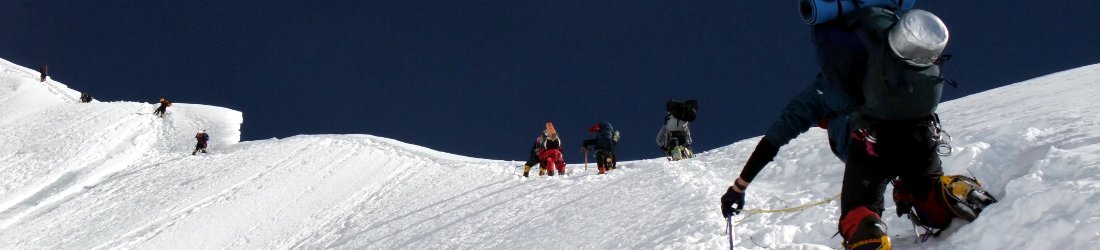
This is more or less true, which means what I write below can only really provide a taste of what followed. We left for the summit at 6.50am. From Chisepo Hut, Sapitwa Peak could be seen rising above the left hand side of a rocky spur, but our route went to the right of the spur, around the back of it before turning left towards the summit. A good path rose steeply through vegetation for a few minutes, but as soon as it reached the base of the spur the scrambling began. Initially it was across sloping slabs with lime green grasses sprouting from every nook, as well as the occasional vellozia trunk. It wasn’t necessary to use hands, but it required great trust in the friction provided by the grip of a boot.

Towards the top of the spur there was more boulder hopping and less slab crossing. By the time we passed around the back of it just after 8 o’clock we had already gone up 500m. With only two or three hundred more to ascend I fancied we would be on the summit by 9 o’clock, but until then the route had been straightforward enough for me to describe. It was around about here, as we traversed beneath the col linking Sapitwa Peak to West Peak, that Moses’ words started to ring true. Red arrows were painted on rocks at regular intervals, and without them even George, who had been guiding the peak for 12 years, may have had trouble following the same route every time. I have rarely followed such a convoluted, mind-boggling course up a mountain. Every boulder field we crossed and every rocky outcrop we passed heralded another one just over the next rise. We shinned up slabs and down the other side, round the edge of boulders on horizontal ledges with airy drops below, and through narrow gaps between others. Frequently we had to remove our packs and push them through ahead of us. We found ourselves in miniature forests between rock faces, avoiding overhanging branches to snag our clothes and bang heads on. There were boulders to crawl underneath and caves to explore. Our cedar walking poles were by turns a hindrance and a help. We had to toss them ahead of us when we needed to use both hands, but often we pulled each other up steeper sections by proffering the end of a pole to tug on. But it was great fun.
The summit marker appeared and reappeared at intervals, but eventually we passed underneath a 50m rock face and scrambled up the back on a 45° sloping slab with no fingerholds (this was a little hairy to edge back down again). There were two more caves to crawl through before we emerged onto the summit rocks, with a 50m traverse along a wide rock ledge. It was incredibly windy up there, with the most incongruous six foot concrete pillar marking the very top, but we found a sheltered grassy ledge where we could sit down and eat some lunch as we admired the view of Mulanje’s many rocky peaks and the lowlands far beneath. It was 10 o’clock, and we were so comfortable up there we remained for half an hour.

It had been a fun climb, but the scrambling became a bit tedious as we traversed across to West Peak. I’m a walker rather than a climber. If I have to concentrate too much on where I’m putting my hands and feet I’m not able to enjoy the view I come to the mountains for, and I find it boring. As soon as we left our ascent route to divert up West Peak there was another fingerless sloping slab where we had to rely on friction alone. George quickly climbed it on all fours and vanished out of sight, but it took me a bit longer. It wasn’t especially difficult, but I was starting to get bored with all the scrambling.
“Are you sure you want to go up West Peak?” I asked Edita. “I’m not sure I can be bothered.”
But luckily she was enjoying herself, and wouldn’t contemplate taking the same route down again. She looked shocked.
“Go on, get a move on. Just get up it,” she said. “We’re not going back the way we came.”
Shamed into action I found a way up the slab by leaning across a crack between it and an adjacent rock wall. I didn’t enjoy it, and made this clearer than I intended.
“Shit, shit, shit,” I said as I ascended.
Edita found it hilarious. “Shit, shit, shit,” she said as she followed behind me with a big grin on her face, showing as much sympathy as Richard Dawkins at a séance. I think this incident was her favourite part of the climb.

Happily the rest of the ascent to West Peak was thoroughly enjoyable, mostly across bare horizontal slabs with the rest of the world far below. There was less scrambling than on Sapitwa and it presented a different sort of climb. We were soon on the summit, marked by a small painted stone with fine views west to the Chambe Basin where we trekked the previous day. Just before we started our descent George reminded us the trail down from West Peak was known as the Scorpion Route, and was a bit more off-road and fiddly than the standard route up Sapitwa. This was like describing someone as a bit more right wing than Hitler, but it soon became clear what he meant. He had guided up Sapitwa countless times, but this was only his third descent of the Scorpion Route and the little red markers were much harder to follow. It wasn’t long before we lost them and had to improvise, sliding down sloping slabs on our buttocks, using the trunks of vellozias as handholds. The tussock grass was particular hazardous and frequently hid leg-sized sinkholes (or man traps, as I began to think of them). But we descended carefully and made it to the grassy plains below without any major traumas. The views across the Chambe Basin to the west and Lichenya Plateau to the south were magnificent, though my use of vellozia trees meant I enjoyed them with sticky palms that Spiderman would have found useful.
Back on the grasslands beneath West Peak George soon located the trail and we descended quickly on a good track to the Lichenya Hut, our luxurious accommodation in pine forest. We reached it by 4pm and were delighted to find unopened bottles of Carlsberg beer sitting on a mantelpiece. The hut had three large rooms, and the middle one had a roaring fire and comfortable dining table where we enjoyed another of Baton’s fine chicken curries.
We had a speedy descent the following day back into the Likhubula Valley, following a parallel track to the one we ascended to the Chambe Basin two days earlier. It was supposed to take five hours to return to the Likhubula Forest Lodge, but we managed to do it in only three. Shortly after 9 o’clock we were sitting on the veranda in rocking chairs drinking morning coffee.
Mulanje had been a revelation. We were very lucky with the weather, enjoying brilliant blue skies and magnificent views. Ours wasn’t the story many people tell about Mulanje’s thick mist and five day storms. We had explored only one small corner of a vast plateau, and ascended only two of its dozens of peaks, but it had been a fantastic couple of days. I would love to go back there one day for a much longer trek.
If you don’t believe me about the intricate scrambling take a look at this video, and there are more photos here.


Nice write-up Mr Horrell. Looked like a fun scramble, in an interesting part of the world and lucky you had strong woman there to keep you from being complete wuss!
Hahahahahahaha, always good to have some banter with my Kiwi chum. Which reminds me, I must get round to watching that 15 minute video of your latest adventure that I keep meaning to watch. You know, the one where you cheated by getting a boat. 😉
Less about the climbing and more about the love interest… You two sound like a match made in heaven! 😉
Nice thought, Matt, but I’m an atheist 😉
Hi Mark,
I’m so glad I stumbled upon this. Great! I may retrace your steps one day.
What would you say is the best time of year for this, and how long would you recommend staying up there?
I have no idea. We went in September for 3 days and were blessed with great weather, but I understand it can sometimes be cloudy and wet. You can easily spend 5 or 6 days there if you want to and climb more peaks.
Hi Mark, thanks for the interesting read and video, I’m trekking Mulanje in November and trying to raise funds for WaterAid at the same time (https://www.justgiving.com/fundraising/Tom-Kennard) and your article has helped a novice trekker feel more at ease and more excited about the adventure to come!
Hi Mark,
Thanks for your very helpful blog – have just returned from Mulanje after a great hike.
Based on your blog had planned to do 3 days exactly the same route as you (inc Scorpion trail) but after an incredible afternoon hailstorm (thankfully only after getting to Chisepo 1pm) on the first day we decided to go up Sapitwa and back to Chisepo next morning just in case the same happened. Luckily it didn’t, so we then went round to Lichenya the low route. The rainy season seems to be starting now which is great news for Malawi in general but on Mulanje it is astonishing how foaming torrents can form in dry gullies within the space of 30 minutes, and of course the slabs are impossible/very dangerous when wet.
Thanks for profound sharing
Hi Mark
Your clip of Sapitwa brought back a flood of memories. I spent 4 years in Malawi during the 70s and spent weekends alternating between climbing the massif and camping on the shores of Lake Malawi. Pretty close to heaven. I climbed with Frank Eastwood and tested his simpler routes for the guidebook with Dennis Atkinson. We all taught at the Blantyre poly. Incredible times. On one occasion we climbed Sapitwa and two adjacent peaks, the kupwetika ( agony) traverse, in one day from the foot of the plateau. Struggle to walk to the shops now! Cheers mate, thanks for the memory.
Pingback:Hiking Malawi’s Highest Peak in ONE Day (No Running Involved) – Intents Travel
Thank you for this superb write up, which I just stumbled on. Many years ago I wrote a short fiction story depicting the protagonist’s “spiritual” experience on Sapitwa…without having ever been to the place. This September I’ll be attempting to reach the peak and your description will be useful. I’ll also be expecting to come face to face with the spirits of the ancestors who, according to my protagonist, dwell up there. My grandfather told me if you’re of good soul and pure heart, you don’t need to carry any food provisions when going up there as these are always provided by the spirits whenever needed; but I’ll probably carry a few snacks just in case…not too sure about the state of my soul and heart.
kodi phiri lamulanje lili panambala chani kutalika muno mu africa
Pingback:18 Best Highest Mountains To Climb In Africa For Beginners (13 Countries)