
This time last year, the Easter holiday weekend fell a week later, and we enjoyed a period of blistering spring sunshine in the Lake District. We raced across hilltops around Grasmoor and Buttermere in conditions as bright as any summer’s day.
A year later and we could be living in another country. It’s been so wet here in the Cotswolds that even the trout have been taking swimming lessons. The river through our garden is still a thundering torrent when it should be a bubbling brook by now. Our garden on the floodplain is often a bog for four months until we get it back in early March. This year the whole valley bottom has been underwater since October, which the farmer up the hill tells me is unheard of. Down the road in Gloucester the cricket season has just got underway, but Gloucestershire’s ground is still underwater. There are going to be a lot of ducks this season.

Alongside the crappy weather, Edita had just returned from an exhausting two months working in Liberia, Angola and Central African Republic, so we decided to do something a bit more relaxing this Easter. Scanning our shelf of walking guides, my eyes alighted on the Vertebrate guidebook Day Walks on the Pembrokeshire Coast. I realised I had never been to the Pembrokeshire Coast on the western tip of Wales, a place renowned for its giant cliffs and secluded coves with hidden beaches.
The boundary of the Pembrokeshire Coast National Park hugs the coastline for most of its length, except in the north, where it makes a short foray inland to embrace the Preseli Hills, a tiny range of open, rolling moorland overlooking the Irish Sea. The Preseli Hills measure about 12km north to south and 15km east to west. They contain 15 peaks over 300m in height and reach a high point at 536m on the summit of Foel Cwmcerwyn, the highest point in the historic county of Pembrokeshire.
We learned in primary school that the Preseli Hills are believed to be the source of the giant bluestones used to build the ancient monument of Stonehenge, 240km away on Salisbury Plain. We were taught that the giant standing stones were rolled across hill and valley on logs. It seemed improbable even to an 8-year-old schoolchild. It must have been one of the most tedious journeys that Britons have ever made. It reminds me of the time a few years later when I found myself crawling home from the Students’ Union.

It was further than I imagined to the western tip of Wales. It took us about four hours to get there from the Cotswolds. Google Maps was having one of its indecisive moods when it changes the route just as you’re approaching the next junction. We ended up taking a scenic route through the Forest of Dean and across the Welsh Valleys, including a diversion into the mining town of Merthyr Tydfil to avoid traffic on the ring road. Merthyr Tydfil is scenic for its setting beneath bleak hills if not for its architecture. The bypass evidently hadn’t bypassed enough of it, as we crept along in roadworks for the next ten miles. Had we been going the other direction, I wouldn’t have been surprised to see druids overtaking us rolling logs.
I phoned the campsite in Maenclochog earlier that morning, and the owner had warned me not to drive our car into the main field unless we wanted to sink it. We managed to find a patch of grass in the caravan area that wasn’t floating and pitched the tent. Later that evening, we had a few pints down a cosy locals pub called the Globe Inn. There were two tiny bars, one with a pool table that seemed impossible to play a shot on without knocking over someone’s pint. In the other bar some friendly locals who had been talking in Welsh squeezed onto a single table to allow us some space. I was surprised to find that I could understand quite a lot of their conversation. It turns out that some phrases, such as ‘fucking computer games’, are the same in Welsh as they are in English.
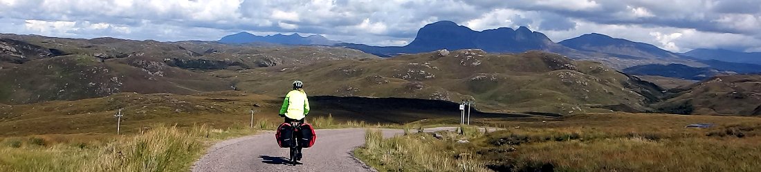
I chose two walks from Day Walks on the Pembrokeshire Coast, a somewhat creative title, given that the first walk was far inland. We varied the walk slightly when we discovered we could start from our campsite and stick in an extra peak to complete the three highest in Pembrokeshire. From the porch of our tent we could see gentle contours of Foel Cwmcerwyn rising 3km away to the north, so the idea of jumping in a car and driving to the start in the guidebook seemed silly. The link path was surprisingly well maintained, along a solid farm track to begin with, then along hundreds of metres of boardwalk through boggy woodland before crossing a shoulder of moorland hillside to join the guidebook’s route.

Foel Cwmcerwyn rises above a modest pine woodland called the Pantmaenog Forest. The forest is managed for timber production, but it has a network of forest trails that are open to the public. The quaintly named village of Rosebush nestles on its western side. According to the guidebook we could relax at the end of the walk in the ‘wonderful Tafarn Sinc’, but I had to google the name to discover that this isn’t a health spa or a hot spring, but a pub. Rosebush also has a row of 19th century terraced cottages that were built to house miners working the slate quarries that scar the western slopes of the forest.
We kept to a broad track that skirted the eastern edge of the forest. Down the hill to our right we could see our tent pitched in a field in front of the village. Miles of farmland stretched behind it. The track became increasingly boggy as we approached the bare summit of Foel Cwmcerwyn. A single concrete pillar marked the top where we were greeted by a howling wind. We had a bird’s eye view of the whole Preseli range. Our peak was right on the edge, but it was clearly much higher than any other. Two more peaks on the northern side also stood proud of the others. One of these, Foel Eryr, was on our route. We decided to divert to the other one, Foel Feddau, because it seemed a shame not to when we were so close.
A single pine tree the height of my shoulder stood incongruously on the bare grassy slopes beneath us as we descended from Foel Cwmcerwyn and followed a stub of ridge to Foel Feddau. It was a longer walk across a boggy plateau and the gentle col of Bwlch Pennant to reach the outlying peak of Foel Eryr. The view to our left was obscured by the pines of Pantmaenog Forest, which crept up onto the plateau, but to our right we looked across open grassland and then a strip of farmland to the north Pembrokeshire coast.
Our solitude was rudely interrupted at a car park beside a road that crossed the top of the plateau. Somebody had nailed a drawing of a penguin to a rock (it was probably a puffin, the symbol of Pembrokeshire National Park).

The summit of Foal Eryr had more to offer than the other two. It was once the site of a bronze age hut and burial cairn, and an observation platform points out features on the horizon. However, the view was blighted by the ugly terraces of Rosebush Quarry biting into the lush green of Pantmaenog Forest. It was too windy to stop for our lunch, so we descended to the north-east in the hope of finding shelter. Shelter there was, but not much else and we ended up having to crouch in a bog to eat our sandwiches.
The rest of the walk was more mundane as we did a big loop, descending into farmland then back up again to rejoin the plateau at Bwlch Pennant. Muddy terrain underfoot and a driving rain into our faces made it a little unpleasant, but the sun finally came out as we descended through Pantmaenog Forest to Rosebush. Tafarn Sinc turned out to be almost as big an eyesore as the nearby quarry, decorated on the outside in — I’m not kidding — sheets of bright pink corrugated iron. The pub interior was pleasantly rustic though, and we enjoyed a quick thirst quencher before returning to our campsite.
It felt like the Preseli Hills were done, but the following day we discovered that the lower hills also have much to offer.
We couldn’t come to the Pembrokeshire Coast without doing a coastal walk, so the following morning we parked beneath Dinas Island on the north coast. Despite its name, Dinas Island is actually a peninsula attached to the mainland by a forested valley. The peninsula slopes upwards towards its northern end, and its highest point is the 142m cliff of Pen y Fan which overlooks the Irish Sea.

We walked a section of the Pembrokeshire Coast Path, a 300km long-distance trail around the entire Pembrokeshire coastline. It reminded me very much of the north Cornwall coast, with its towering cliffs flanked by sheep-cropped grassland and steep trails descending into hidden coves. Sea birds gathered on rocky islands offshore, and we looked across Fishguard Bay to the the wide docks and breakwater of Fishguard Harbour.
We turned inland to climb back up to the Preseli Hills and the outlying peak of 307m Mynydd Dinas. The highest point of this otherwise gentle moorland hillside is actually a 10m rock outcrop with quite a nice scramble to its summit. We hoicked ourselves up a couple of giant boulders, then traversed a horizontal crack in a sloping slab to reach a narrow gully that led to the top.
This was a surprisingly varied walk. We descended back through farmland, but before returning to the coast we passed along the narrow gorge of Cwm Dyffryn through terrain that has recently become known as temperate rainforest. Ferns lined the banks of the trail and carpets of wild garlic were already coming into flower as ivy clung from branches. We even passed a small waterfall.
By gum the trails were muddy though. There are some seriously squidgy footpaths after the winter we’ve had and this section was up there with them. It reminded me of this classic YouTube video (although Edita and I were wearing big leather walking boots for just such terrain, which made us a little more sure-footed than the young chap in this clip. We managed to stay on our feet).
We finished the walk by returning to the Pembrokeshire Coast Path and enjoying the narrow clifftop trails around Dinas Head. It’s always nice to explore a new range of hills and a new stretch of coastline. Wales has both in abundance.
You can see all photos from the trip in my Preseli Hills and Pembrokeshire Coast Flickr album.
Walk 1: Foel Cwmcerwyn (536m), Foel Feddau (467m) and Foel Eryr (468m)
Total distance: 24.27km. Total ascent/descent: 733m.
View route map and download GPX
Walk 2: Mynydd Dinas (307m) and Dinas Head (142m)
Total distance: 17.60km. Total ascent/descent: 674m.
View route map and download GPX


