
It’s not often you get great weather on Snowdon, but there was a good weather forecast the other day so I decided to head up there. Many people describe the highest peak in England and Wales as hill walking’s equivalent of the Black Hole of Calcutta, but this is a little unfair. It’s such an interesting mountain, with many interconnecting ridges and summits, that it’s usually possible to find a route up that avoids the crowds, at least until the summit.

I chose one such route, the Watkin Path, on this occasion, via peaceful Cwm Llan on Snowdon’s southern side. Opened in 1892 by Sir Edward Watkin, a railway tycoon who owned a cottage in Nantgwynant, the lush valley that runs along Snowdon’s southern boundary between Pen-y-Gwryd and Beddgelert. He was also a Liberal MP, and on the occasion of the path’s opening he managed to persuade his boss, the 83-year-old William Gladstone who at the time was British Prime Minister for the fourth time, to walk up the path and give a speech. Gladstone made it as far as a large rock in Cwm Llan, about a quarter of the way up where he gave his address and, according to a plaque which now commemorates Gladstone Rock, “the multitude sang Cymric hymns”. No, I don’t know what a Cymric hymn is either, but Gladstone Rock sounds like an Elvis song.
The Watkin Path also happens to be the longest route up Snowdon in terms of vertical ascent, starting from just 60 metres above sea level in Nantgwynant (by contrast Pen-y-Pass, starting point for the Miner’s Track, Pyg Track and Snowdon Horseshoe, stands at 360 metres). As I set out at 9.30, the remnants of a valley fog lay over Nantgwynant, which I could see below me as I climbed, giving the valley a magical quality. The trail starts off in woodland but rises quickly into boggy moorland on its way up to the grassy amphitheatre of Cwm Llan. For a crisp bright Sunday I was amazed how quiet it was. For the first hour of the walk I saw only two other people, one a fell runner spoiling a lovely walk by ascending far too quickly, and the other a lone backpacker on his way down from a wild camp dressed like a commando (by which I mean he was wearing camouflaged clothing rather than no underpants).

Old abandoned stone mine buildings and small waterfalls are a characteristic of this part of the walk. Cwm Llan has a very homely feel to it, a wide green elevated sanctuary between hills, the modest triangle of Yr Aran in the distance to the left, and Y Lliwedd looking over the path to the right. Gladstone Rock is more of a grassy knoll than a large boulder. As I walked past I tried to imagine a distinguished old gentleman standing on top of it giving a speech while a gathering of sooty miners stood around singing Welsh hymns in close harmony, but it was difficult to take the image seriously. I guess things were different in those days. At Gladstone Rock the path swings to the left with Snowdon still hidden behind a small crag beneath Y Lliwedd. Beyond the crag it swings back to the right and at last the whole view of the Snowdon’s southern side opens out, with the summit up ahead and the southeast ridge dropping off it to join with Y Lliwedd to the right. We are now in the steeper amphitheatre of Cwm Tregalan, and the path, which has been rising slowly through Cwm Llan, becomes much steeper as it slants up the south side of Y Lliwedd. At this point I stopped my gentle ambling and quickened my pace up a good solid path which joins the ridge a little below the left-hand end of Y Lliwedd, overtaking a few people on the way. After a steep climb up the flanks of Y Lliwedd the path turns to the left to follow the southeast ridge on a gentle incline.

The final 100 metres or so up to the summit is up a steep rocky path round the left hand side of a summit dome. The Watkin Path joins Snowdon’s south ridge, and turns to the right to follow the ridge up to the summit. A very different view to peaceful, enclosed Cwm Llan and Cwm Tregalan is to be had upon gaining the south ridge. Snowdon is only about 12 miles from the sea, but there’s a lot in between, first the woods, lakes and villages of the Nant y Betws valley, then a small line of hills including the fiddly Nantlle Ridge and the hog’s back of Mynydd Mawr, then a flat, surprisingly densely populated coastal area. This was far from being my first ascent of Snowdon, but it was the first time I’ve looked upon this view. The summit of Snowdon is usually about as clear as Boris Johnson explaining the finer details of quantum physics.
It was also my first chance to see Hafod Eryri, Snowdon’s (relatively) new summit visitor centre and café, which was opened in June 2009. There have been buildings on the summit of Snowdon since the 1830s, when a miner called Morris Williams (now there’s a Welsh name) realised there were so many people walking to the summit that he could make a few bob if he provided refreshments for them when they got there. Shortly afterwards a couple of rudimentary hotels were built on the summit for people who wanted to sleep overnight and watch the dawn. The Snowdon Mountain Railway opened to the top in 1896, and a new summit railway station and hotel was built in 1936. The last summit building was a bit ugly. Prince Charles once described it as the highest slum in Wales, though I’m not sure he knows what a slum is (he probably thinks it’s a working class single mum). He also called it a carbuncle, but then you could say the same thing about Prince Philip.

They knocked down the carbuncle in 2006 (the old summit building, that is), and began building the new one. Many people objected and believe Snowdon’s summit should be free from buildings. You can see their point, but it’s a bit of an old-fashioned argument. The railway and the summit buildings are now part of Snowdon’s history, and the mountain wouldn’t be the same without them. Snowdon remains the only decent sized hill in Britain where you can buy a beer at the top, and it would be a shame to lose that. Complaining about the summit building is a bit like complaining about there being a giant ferris wheel on the banks of the Thames near Westminster Bridge. Hafod Eryri is actually quite a nice looking building which blends in quite well. It squats just below the summit cairn a bit like the lantern room at the top of a lighthouse (a few more people inside it, mind you). Before I stopped for the obligatory pint there was the small matter of the summit cairn. For the average hill walker, reaching the summit of Snowdon is worthy of a pat on the back and a sandwich, but nothing more. The majority of Snowdon summiteers are not hill walkers, however, and for them it’s a big deal. A group of teenage scousers were standing on top of the trig point, and a few people were unfurling banners with their sponsors’ names on to have group summit photos taken. I stopped to take their photos for them, and they expressed amazement at there being a café up here. I had a ropey pasty and a bottle of Snowdonia Ale at a table looking out of the glass wall towards the sea. Every so often a mass of bodies in smart jeans and impractical footwear spewed through the entrance signalling the arrival of a train. It would be nice to shelter in there when it’s pissing down, but otherwise it’s much nicer outside, and some of the more hardy-looking stalwart walkers were doing just that, eating their sandwiches on a ledge in front of the building.

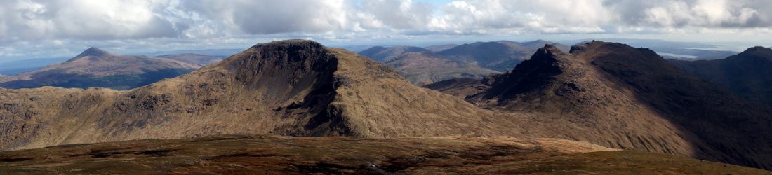
It was time to head down, and I chose to descend via the south ridge across Bwlch Main, a rocky outcrop on the ridge which used to have the amusing name of Clawdd Coch. It’s no longer marked as this on Ordnance Survey maps, and I presume the name got changed at some point because it made one or two hen-pecked male surveyors feel a bit uncomfortable. Most people seem to climb Snowdon either from Pen-y-Pass in the east or Llanberis in the north, so a few metres below the crowded summit I was alone once more, and only met a few more walkers for the rest of the day. On a clear day the south ridge is certainly a picturesque way to descend. Y Lliwedd and Cwm Tregalan, my route of ascent, were below me to my left, and a line of smaller hills rising in front of the Irish Sea to my right. It didn’t take me long to descend the 500 metres to Bwlch Cwm Llan, the col between Snowdon and Yr Aran, Snowdon’s southernmost summit. It was still early in the afternoon and I decided to reascend the 200 metres to the summit of Yr Aran. This was a good decision. I had discovered a quiet corner of Snowdon away from the crowds. It was a good place to study the south side of Snowdon across Cwm Tregalan and the knife-edge serrated ridge of Crib Goch beyond. I had the summit of Yr Aran to myself for about half an hour until a man with a dog turned up as I was leaving and started whistling directions to his wife far below. I descended the grassy east ridge of Yr Aran to rejoin the Watkin Path, and was back at my car in the Nantgwynant Valley about 6½ hours after setting out.
I also discovered a peaceful campsite in the valley on the shores of Llyn Gwynant, with an admirable “no radios” policy. At 10.30pm, by which time I’d been asleep for two hours, somebody found a way to circumvent the tranquillity of the campsite by turning up late and slamming their car door around 200 times in the space of ten minutes, an activity which wasn’t explicitly banned in the campsite rules. At some point during the evening of a camping weekend I usually discover I’ve forgotten one of the following items: torch, toilet paper, ear plugs, or pee bottle. None of them are essential, but all of them make camping a whole lot more luxurious. On this occasion it was the ear plugs, but luckily you can bung up your ears with toilet paper a lot more easily than you can wipe your backside with ear plugs.
It had been a good day out, though. I had proved that it’s possible to avoid the crowds on Snowdon (though not on the summit) and with 1300 metres of ascent and descent in the day, the Watkin Path and Yr Aran make for a good bit of exercise.
Here’s a little video I made from the summit of Yr Aran, and you can see my photos of the walk in p.3 of my 2012 Flickr album.


What wonderful scenery. I’ve been to Wales but never for the walking – must put it on my list 🙂
Absolutely you must – when the weather is fine the whole of Snowdonia is stunning. 🙂