
It’s years since I last visited the southern part of Snowdonia, and I was long overdue a return. In 2008 I stood at the far end of the northeast terrace of Cadair Idris, Snowdonia’s most southerly mountain, and gazed across emerald farmland to a range of hills on the eastern horizon that appeared to be higher. At 907m Aran Fawddwy is the highest peak in the United Kingdom south of Snowdon itself. In 2011 I saw these hills again from a distance during a two-day backpacking trip to the Rhinogs.
Snowdonia’s highest peaks are found in the north. All 14 of the Welsh 3000ers (that’s 3000 feet, not metres) are found there, most of them clustered tightly together. Those peaks are well known and well explored. Snowdon itself sees hundreds of visitors every day, and its neighbours Tryfan, the Glyders and Carnedds can also be busy.
Aside from Cadair Idris, which overlooks the seaside town of Barmouth, southern Snowdonia is much quieter. Several isolated mini-ranges are spread out over a wide area, and few people know about them. I wasn’t really aware of the Arans until I looked out from an outlier of Cadair Idris seven years ago, and the Rhinogs felt like a secret gem when I visited in 2011. This time I discovered yet another range, the Arenigs as I looked north.

It’s taken me a while to get round to visiting the Aran Hills, but last week I spent two days there, traversing all their main summits and camping out on top of one. They are essentially a broad, grassy 10km ridge, studded with rocky outcrops, and extending north to south. On their eastern side they fall abruptly in a series of cliffs, beneath which a tiny lake, Creiglyn Dyli, nestling in a hanging cwm is the source of the River Dovey. At the southern end the ridge fans out into a huge boggy plateau before rising to a final summit, Glasgwm.
I started from the north in the barely pronounceable village of Llanuwchllyn close to the shores of Bala Lake, and after a short walk up a farm track I soon found myself climbing through farmland onto the beginning of the ridge. For the first four kilometres a good trail rose gently alongside a stone wall on pleasant grassy slopes. The landscape was very open, with views for miles. As well as the lake, the Arenigs were prominent behind me to the north, and two smaller hills, Dduallt and Rhobell Fawr, rose beyond forest to my right.

It’s a long approach from this side, and it was the start of a two-day heatwave that saw temperatures soar to a barely believable (at least for the UK) 33ºC. I was drinking water like it was beer, and I had already been through a litre by the time I approached the first summit, 885m Aran Benllyn. There was a tiny pool, Llyn Pen Aran, just beneath the summit, where I rested against a rock in the long grass and refilled my bottle.
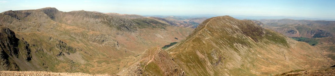
For the next hour, as I traversed the highest part of the ridge to Aran Fawddwy, the view was at its best, a real roof-of-the-world feeling as the land fell away steeply over crags to my left. The route undulated among rocky outcrops before rising steeply to the highest point in the Arans.
I reached Aran Fawddwy bang on midday, after 3½ hours of walking. As I stopped for a sandwich I could see the Irish Sea, Cadair Idris and the Rhinogs in the far distance to the west, the latter dark and table-like.

It was beyond here that the ridge broadened and fell away into a vast boggy plateau. I could see the rest of day’s walk all the way to Glasgwm on the other side of the bog. To the east the bog ended abruptly at steep cliffs which fell away into deep valleys, pleasantly green in the warm summer sunshine.
To begin with I kept away from the bog by following the cliff’s edge. I dropped 100m to a place where an eastern spur came to join the main Aran Ridge. I had a beautiful view behind me down into the secret cwm beneath the cliffs of Aran Fawddwy, and the black lake of Creiglyn Dyli which was hidden from view from the ridgetop. Its shores would be a great place to camp, but I wouldn’t be passing by there until the following day.
A cairn had been erected at this meeting of ridges, and there was a sombre moment as I stooped down to read its plaque.
“This cairn was built by members of the Royal Air Force St. Athan mountain rescue team in memory of S.A.C. Michael (“Mike”) Robert Aspain who on 6th June 1960 was killed by lightning near this spot whilst on duty with the team.”
That was 1960, but only last weekend two walkers were tragically killed by separate lightning strikes while hiking the Pen y Fan ridge not far from here in South Wales.
My biggest danger for the rest of the afternoon was wet trouser legs as I crossed the bog to the foot of Glasgwm. Planks had been laid down as a boardwalk in the wettest parts, and it was here that I passed the only human being I was to see during the whole two days I was in those hills, making his way up to Aran Fawddwy in the other direction. After five hours of total solitude I was as surprised to see him as I would have been to see a talking sheep.

“You’re the first person I’ve seen all day,” I said as I passed him.
He looked surprised. “Oh, there are others down in the valley,” he replied.
But I didn’t see anyone the following day either.
If there was a trail up Glasgwm I didn’t find it, and it was hard work as I took a rufty tufty route up a steep grassy hillside, zigzagging to stay on my feet with my loaded pack. After 250m of this I was a little tired when I reached the top and realised I was the wrong side of a fence. I had to hop over it to reach the man-sized summit cairn.
It was still only 3pm and I had been walking for 6½ hours bar a couple of sandwich breaks. It was a little windy, but I found a sheltered spot on the western side of the cairn, and fell asleep on soft grass in the sun with, it seemed, the whole of North Wales beneath me.

When I woke up an hour later the sun was still bright and I felt refreshed, but 10m below the summit of Glasgwm was an inviting blue lake set within another grassy plateau. It had wild campsite written all over it, and now that I was at the northern end of the Arans I realised I didn’t have to go a step further that day.
I pitched my tiny 800g Terra Nova tent on its shores, put a brew on, and settled in for the rest of the afternoon. By 9pm it was still light and I was able to keep the front of my tent wide open as the sun reflected off the waters of the lake outside my door.
As I put the finishing touches to my own book about Everest I’ve been busy reading other people’s. On this day I had a copy of Bear Grylls’ book Facing Up on my Kindle, and rattled through it as I brewed mug after mug of tea and swallowed a few mouthfuls of food. If you’re thinking of reading this book yourself, here’s a short paragraph to help you make up your mind whether it’s your thing.

After a blissful night’s sleep in as peaceful a location as anywhere I’ve camped, I woke up early, packed up my tent and was away at 7.30 the next morning. My second day wasn’t quite as memorable as the first, but a couple of moments stood out.
It can be broken down into two parts. For the first half of the day I remained in the hills, but instead of staying on a ridge, I dropped into valleys and climbed back up and over them. The second half took me through farmland on public footpaths which were marked on my map but not always evident on the ground.
I dropped down off Glasgwm by way of grassy bogland on its southern slopes with good views of Cadair Idris to the west, and descended into the secluded Cywarch valley. A minor road runs up this quiet cul-de-sac, and a car park at the top end forms the starting point for most day walks up Aran Fawddwy. I took a quieter trail which slanted up a side valley onto another boggy plateau, Waun Goch. The trail eventually curled around to form the spur which rejoins the main Aran Ridge at the memorial cairn I visited the previous day. Instead of continuing along this ridge and back up to Aran Fawddwy I dropped down a very rough steep hillside to the black lake Creiglyn Dyli, which nestles beneath the Arans’ highest peak.

It was lunchtime by the time I reached it. The trails had been rougher in places that morning and I was already quite tired, but it was a pleasant place to stop and rest, looking across the lake and up the cliffs to the summit. I don’t know whether those were cliffs that would attract a rock climber. There were so many grassy ledges sweeping across them that football boots would probably be more useful than rock shoes.
I ascended another outlying hillside before descending into the valleys for the remainder of my walk back to the car. There were some pleasant footpaths through woodland, but there were also some rough ones across farmland, and there was a nasty moment when I had to cross a field of cows.
Despite their size cows are generally pretty docile and can be frightened off very easily by charging towards them uttering a few choice profanities. A bit more caution needs to be exercised when calves are nearby, however, and amazing as it sounds, twelve people have been trampled to death by cows in the last six years in the UK.
I was walking on a public footpath which passed along the bottom edge of a field set on a hillside. To my right was a barbed-wire fence, while to my left a number of angry-looking cows crowded around on the slope above me. About 50m in front of me a calf grazed beside the fence. I assumed it would get out of the way as I approached, but it didn’t, and instead it stood rigid, staring at me like a frightened rabbit caught in the headlights.
I slowed down, and started talking to it, encouraging it to move away from the fence.
“Go on, fuck off, fuck off!” I urged, with growing urgency.
The calf didn’t appear to understand, and remained where it was. As the increasingly-agitated cows gathered around me I realised I was about to become trapped, with no means of escape over the barbed wire to my right. I was a prime candidate for trampling, and there was nothing for it but to turn around and walk briskly back the way I had come. I was cursing by the time I reached the safety of the gate.

I now had to find an alternative route around the field, which meant climbing carefully over another barbed-wire fence, that well-known destroyer of many a perfectly good pair of trousers. I still have a three-inch scar on the inside of my thigh after crossing one in shorts five years ago. This time I managed to get across without ripping any of my clothing, but I did cut my hands in the process.
This was my only nasty moment, and thereafter I encountered only sheep, which in Wales are terrified of people and sprint away from you even if you’re not interested. A bigger annoyance were the flies, which swarmed around me when, parched with thirst in the hot sun, I stopped to refill my water bottle from a woodland stream.
I reached my car at 4.30 that afternoon. The second day of the walk had dragged on a little towards the end, and had been a little tougher than the first, but overall it had been a grand couple of days’ backpacking.
There aren’t many proper hill walks this close to civilisation in the UK where you can spend two days and only see one other human. The Arans are unlikely to become busy any time soon, and if you’re looking for some quiet hill walking just four or five hours’ drive from London, I very much recommend the Aran Ridge.
Next stop for me will be the Arenigs. I still have plenty more places to discover in the Welsh hills.
You can see my complete photo album from the trip on Flickr.


Love the new-look blog, Mark – the photos look brilliant!
Thanks, Matt, glad someone noticed. There’s nothing like transferring 20,000 photos to Flickr to make you yearn for the mountains. After 8 years of the old design, the website was starting to look as dated as some of my jokes!
“Try and keep comments concise and avoid rambling.” I might have to ramble a bit here…I am not a climber or even a sporty person just an armchair reader who is obsessed with the Everest and all things mountains. I stumbled upon your blog while searching for Everest articles and had a few laughs; man, you are a riot! I enjoyed this post, your encounters with the cows…the Bear Gryll mention. Your pictures are breathtaking, stunning landscape!
Beautiful mountains, beautiful river, natuaral beauty, this is wonderful place for camping. I would like to visit this place and enjoy the beauty of nature. good work to bring these beautiful pictures in my notice.
” I was drinking water like it was beer” – that cracked me up for some reason. We had 38° here in the southwest of Germany, so I understand you perfectly.
Thanks for this post and the great tips for places in Wales which aren’t as crowded as Snowden and Cadair Idris. If I ever make it to Wales again, which I hope, I will check them out.
The new look of your website is great and I love the quality of your photos now! Browsing through them will provide entertainment for weeks to come!
The new look blog is certainly easier to read (even with your dire jokes, Mark!), but it’s the photos that really make a difference. I spent a good half an hour last night looking at the photos of your Everest ascent on Flickr, which truly are awe-inspiring!
https://www.flickr.com/photos/markhorrell/sets/72157653693710001
I think your time uploading them was well-spent, and I shall return to relive some of your other adventures – from the comfort of my armchair – when I get a moment! Cheers, Matt.
Thanks everyone for the kind words. Glad it was all worthwhile, and nice to know there are people who read my posts from start to finish. I do sometimes wonder about that.
And I know jokes about beer are always appreciated in Germany 😉
Great places to come, Mark. Thank you for showing us the world. Keep following and reading your blog.
“Angry looking cows” ha ha ha
I live in Wales, but the closest I’ve got to Snowdon was an aborted trek when on a school trip in year 6 of primary school! My son loves the outdoors, but I’m not sure if we will go for a summit attempt just yet. Your blog is giving me lots of ideas for shorter walks/microadventures (ha ha) in the area though. I grew up in Mid Wales, and as a child I never understood why people visited the area from a city!
I really enjoyed your book and its the first one I’ve ever properly reviewed on Goodreads (although I’m sorry to admit I also enjoyed Paths of Glory and Archer’s prison diaries)
Pingback:The Aran Fawddry Circular Walk- Here Is Why I Loved It. - Exit Street View