
There is no doubt that one of the most jaw-dropping experiences of my recent visit to the Langtang Valley in Nepal was passing through Langtang village, the site of a devastating landslide during the 2015 earthquake. Yesterday was the second anniversary of that terrible event, so it seems like the right moment to remember what happened, describe what I saw two years on, and see what the future holds.
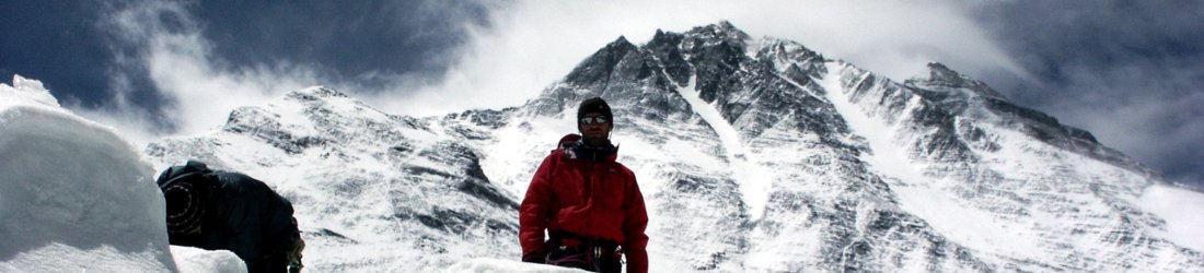
The Langtang region sits on Nepal’s border with Tibet, a short distance north of Kathmandu. It’s a narrow valley running east to west, wedged between dramatic 6,000 to 7,000m snow-capped peaks, the highest of which is 7,227m Langtang Lirung. Its western end can be accessed by road, five or six hours’ drive from Kathmandu, or by a four to five day trek through the forested hills of Helambu.

For many years it has been consider Nepal’s third main trekking region after the Khumbu (Everest) region and the Annapurnas. While not as popular or developed, there is sufficient infrastructure for single and independent travellers to teahouse trek, travelling from village to village and staying each night in accommodation along the route. This means that it’s possible to trek there without needing to hire staff and logistics for a camping trek. This and its proximity to Kathmandu has made it more popular with travellers on a budget or shorter timetable. It’s one of the few areas of Nepal where treks of two weeks or less are practical.
The Langtang Valley starts from an altitude of 1,500m beside the road at Syaphru Besi, disappearing up a narrow, forested gorge. For much of its length it is less than a kilometre in width, and the mountains rise sheer on either side. The valley ascends steeply, and gradually widens before emerging into wide open spaces at Kyanjin Gompa (3,850m), where the last teahouses can be found. Most trekkers go no further than Kyanjin, but the valley continues east, right up to the high glaciers of the Tibetan border region.
There are several villages and teahouse communities between Syaphru Besi and Kyanjin. The largest of these was Langtang village, at 3,400m. It used to be a thriving community of teahouses sitting in a bowl, a wider haven within one of the narrower sections of the gorge.
The earthquake and landslide
This all changed in an instant at 11.56am on Saturday, 25 April 2015. Langtang village lay directly beneath the south face of Langtang Lirung, where there was a large glacier and a frozen lake sitting in a hanging valley high above. This glacier and lake were the source of a river which ran down a wide couloir or gulley, past the western end of the village to join the main Langtang valley.
When a 7.8-magnitude earthquake shook Nepal that morning, a vast landslide fell off Langtang Lirung. It was as though an entire section of mountainside came off, bringing with it giant boulders, much of the glacier, and the entire frozen lake. An estimated 40 million tons of rock and ice was funnelled down the couloir, straight onto the village. It produced a gust of wind so powerful that the air pressure flattened every tree on the opposite side of the valley for many kilometres downstream.
Around 9,000 people died during the Nepal earthquake of 25 April 2015. This tiny village in the Langtang Valley accounted for 243 of them: 175 villagers, 27 local tourism staff (guides and porters), and 41 foreign trekkers. All of their names are now recorded on a memorial mani wall that has been built among the wreckage.
Here they are. If you have trouble reading this slideshow, the names can be read clearly on the full resolution images you can scroll through in my Flickr album.
While nobody in the main part of Langtang village stood a chance of survival, some people in houses around the edges did. Strangely, more elderly people survived than young people. The reason for this is because they stayed indoors. Traditional Nepali houses are built on two levels. The top floor is always living accommodation, while the lower floor is for storage and animals.
When the earthquake shook, the natural instinct of younger people was to run outside so that they wouldn’t be crushed by their own houses falling around them. What they didn’t know was that outside was a far greater danger. A few seconds later they were killed in the landslide that followed. Older people, however, didn’t try running. Instead, they took shelter downstairs. A handful of them survived the tragedy.
There were other landslides all the way down the Langtang Valley, and the evidence is everywhere. Trails were destroyed, and people up the valley were trapped for days after the earthquake, until Nepal’s small number of helicopters were freed up to evacuate them. Infrastructure was devastated. Homes were destroyed, and the collapsing trails meant that supplies could come up to Langtang only with great difficulty.
Of course, tourism to Langtang suffered, and many locals were deprived of the regular seasonal income they had become used to. Months later, when the cold weather came, many people were still in temporary shelters, and there were more deaths that winter.
Langtang village two years on
This was my first visit to Langtang, so I have no memory of what the place was like before the earthquake. There had been a lot of snow in the days before our arrival, and this concealed much of the evidence the first time we passed through the village on the way up.
Famously a single house survived the landslide that destroyed the old Langtang village. This house was built so close to a cliff on the north side of the valley, it was almost within an overhanging cave. This allowed most of the rock and ice to pass over it, but even so, a large corner of the front of the building collapsed. The house now sits derelict as a stark reminder, its presence drawing even more attention to the ruins around it. It feels haunted, and probably is.

A memorial mani wall has been erected a short distance in front of it. Mani walls can be found all over Buddhist areas of the Himalayas. They are inscribed with the mantra om mani padme hum, and many (including this one) are hung with prayer flags and wheels for the Buddhist pilgrim to spin. This one also contains plaques listing the names of all 243 victims of the landslide at Langtang village.
A new Langtang village is being built 100 metres above the ruins of the old one. This new site looks to be marginally safer than the old one, because it is not directly beneath the couloir that funnelled down the devastation two years ago. However, it is still extremely close to the steep cliffs on the north side of the valley. Although vertical cliffs are less likely to carry snow, and therefore less prone to avalanche, it still feels like rockfall will be a considerable hazard.
And yet, just half an hour’s walk up from Langtang is the village of Mundu. Here the valley is broader, the houses are not so close to the cliffs and it feels a lot safer. I didn’t find out enough about property rights in Langtang valley. It lies inside a national park, so I don’t know whether land is privately or government owned. Why they are building a new village almost exactly where the old one was destroyed I don’t know. It would seem far more sensible to abandon the site and move all the villagers up to Mundu. A couple of hours above Mundu is Kjanjin, where the valley is much wider and safer still.

New teahouses are being built in Langtang village, but they’re currently a lot more basic than those in other parts of the Langtang valley. This isn’t surprising, and I expect they will soon be brought up to a similar standard. We stayed a night in one of them, because it felt like the right thing to do. I have to admit that I didn’t feel completely safe there, and Edita (who was at Everest Base Camp during the earthquake, where a similar, if less devastating, tragedy occurred) told me that she felt likewise.
These were our first impressions, but a week later we came back down the valley after the snow had melted. This time the devastation was unavoidable, and it was of a scale far beyond anything I could possibly have imagined.
Mountaineers are used to seeing boulder fields, but this was something different. The bowl where the village used to lie was entirely covered in rubble. The area had been so devastated that, apart from the house built tight against the cliff, there was not a single shred of evidence that there had ever been a village there. The old village had been completely flattened and buried beneath an outpouring of rock the like of which I have never seen in my life. A massive area, perhaps a mile wide and two miles long had been swept by a sea of grey rock, from the canyon walls to the river.

Nothing remained, and two years on not a single blade of grass grew among the cracks. The rubble sloped gently down from the couloir, and it wasn’t difficult to imagine where it came from. The side river, which once came down from the frozen lake, was no longer there. Both the river and its bridge lay beneath the rock, like everything else — a landslide so total, it had wiped a whole river out of existence.
I have never seen such devastation before. It was total annihilation. Perhaps this is what the trenches looked like after the Somme, but I can’t imagine many war zones could be razed as savagely as this.
For many kilometres below Langtang the trees on the south side of the valley had been flattened. That side of the valley was once forest, but now logs cover the banks like giant matchsticks. Not a single tree is still standing, a consequence of the air pressure that was released as the landslide fell. Makeshift timber yards have been set up on beaches in the bottom of the valley, and porters carry planks up the valley to rebuild houses. There is a question mark over how this will affect erosion. Forests help to prevent landslides, and without the trees it seems likely this valley will become even more dangerous.
These fallen trees on the south side of the valley are mirrored by fallen buildings on the north side. Many of these were hit by smaller landslides, but some just fell down in the earthquake. None of them have been rebuilt, and they lie abandoned along the trail.
Before I examine what the future holds for Langtang, here’s a short video of what we found last month.
The future of Langtang
Despite the devastation, dare I say it but things in Langtang are getting back to normal. The infrastructure exists for teahouse trekking again. Teahouses have been rebuilt, as have the trails, and there are regular deliveries of supplies. Even in Langtang village teahouses are open. There is wifi all the way up to Lama Hotel, and you can find patches of NCell connectivity (the local phone carrier) as far up as Kyanjin. I found the teahouses a little more basic than those in the Khumbu and Annapurna regions, but I don’t know whether this was also true before the earthquake. The menus are almost all vegetarian, but you can’t have everything.
I have been told that tourist numbers to Langtang are nothing like what they were before the earthquake. From the evidence that I saw, it is still seen as budget trekking destination. We were the only mountaineers, and the only people who had hired a sizeable crew for our trek. We had a guide, a cook and six porters. We were the only people camping, and no other trekkers we saw had more than a single guide or porter accompanying them. We didn’t pass any large groups. It was independent trekkers only.

Nevertheless, the local people are enterprising. They are used to making a living from tourism, and I believe the area will recover, as long as there are no more natural disasters on this scale.
If you are wondering how to help the people of Langtang, then I would say that beyond a doubt the best thing you can do is just go there for a nice holiday, have a good time, hire a porter and spend your money in the teahouses.
It may be a little controversial to say this, but if you are thinking of fundraising or volunteering then reconsider. Unless you have a particular project in mind, or a skill you can provide, your labour is less useful. There is no shortage of labour in Nepal, and the foreign, unskilled variety is of questionable value. As for donations, you can never be sure exactly where your money will end up.
While I’m certainly not saying that donating or volunteering is harmful, tourism is a much better route to prosperity, for it allows the people of Langtang to become self-reliant and make their own living. If you want to do some fundraising then why not get a group of friends together instead, and organise a group trek. If you can’t do this, and still want to give money, do your research before deciding who to donate to. Much of the advice I wrote at the time in a post about donating to earthquake victims is still relevant.

We also need to promote the Langtang region as more than just a cheaper and shorter alternative to the Khumbu and Annapurna regions. We made some great discoveries during our trek there last month. It’s possible to do a fantastic three-week trek through Helambu, over the Laurebina La to Gosainkund, then back again from Kyanjin over the Ganja La. We were also eyeing up a longer, more remote trek across Tilman’s Pass. This more challenging route lands you right in among the glaciers and towering mountains east of Kyanjin. This itinerary is best done by means of a fully supported camping trek with porters and kitchen crew, employing more staff and feeding more mouths.
We can never forget what happened in Langtang two years ago — that evidence will remain for longer than we do. But the local people will move on and recover from those events. Not only can we help them, but we can do it willingly, and have the time of our lives doing it. Too much of what we read about is negative; but the future can be positive. We just need to think about things differently. I talked about these contrasts in my trip report a couple of weeks ago. I want you to think of Langtang — and the world in general — as a wonderland, not a wasteland.
You can see all the photos from my visit to Langtang in my Flickr album.


Hello Mark,
I did a trekking in Langtang valley mid december 2010, so about one and a half year before the earthquake stroke. I remember Langtang valley and Langtang village very well. I heard about what happened there like two weeks after the first reports of the earth quake hit the news, and I was in shock. It crossed my mind today, and started googling wondering what had become of Langtang, and found your blog.
Big thanks for sharing.
I remember Langtang Village as a great place, full of joy and space (not only literally after having been crossing that narrow valley up thered for days.)
I especially remember my tea house hosts, they were such relaxed and warm and welcoming people. I don’t remember their names, but i fear that they are all listed on that memorial wall as well. May they rest in peace.
One picture that you took in Mumbu struck me. It’s the one with the sign ‘Welcome to Himalyan Guest House’ in the middle. The yellow plate. I stayed in the tea house with that name back then. And they had this same yellow plate hanging on the wall of what was back then a two story building.
Talk about resilience..
Thanx again for sharing!
take care, cheers,
Jeroen
Thanks for the info and the high res pics of the memorial. i wonder if Pim’s place survived? I couldn’t find his name on the list, although perhaps Pim is a nickname. He is Tibetan I think? There is/was a small cluster of teahouses a couple of miles before Langtang village as you trek up the valley. Although this cluster is above the langtang village basin. Pim is a very cool guy, his hospitality was special, laid-back and not pushy. We shared beers and smiles. His elder daughter made better soup than anyone else in the valley, which isn’t saying much but that’s not why we go there. His young daughter would probably be about 11yrs now. I was there in 2011. Did you meet Pim?
No, sorry. I did not meet Pim. The area below Langtang village was quite badly affected, though there were a few houses still standing.
Thank you for the wonderful write-up. I was there in October 2013. I can share photos if you are interested. The accommodation was certainly more basic than in Annapurna but they were in the process of building some bigger and grander-style hotels. I imagine April would be a far quieter time than October, but it was certainly a much less touristy spot than Annapurna region (although I didn’t do the whole of Annapurna).
Such a shame about the trees too, the forest-bit was one of my favourites.
I remember when I saw the devastation on the media at the time I could hardly believe it, a whole village just annihilated as you rightly say. And I could very easily have been there!
It is great to hear that the local communities are literally picking up the pieces and rebuilding and I agree with your comments about helping by going as a tourist.
Very nicely written article. Probably the best on langtang I’d say.
I just trekked the langtang route and saw the massive devastation on my own. It was a shocker for me. A 30-40 minute stretch of landslide area is just massive to imagine. I myself was stuck in the earthquake but I had never imagined the devastation was such huge in Langtang.
A local informed me that there was a funeral function going on in the village on that day and because of this, many had gathered from nearby places, which led to higher deaths. But the conditions are normal now, the villagers have moved on but some of them indeed are in poor state.
Many living in the higher regions of Gompa, used to come down to langtang during the winters but now since many of their houses are lost due the the landslide, they go to kathmandu in search of work during extreme winters and back to their village for their chores and run their hotels during other seasons.
I
Hello Mark,
Thank you so much for the thoughtful article and wealth of photos. I had the privilege of working years ago with The Mountain Institute, a non-profit group who collaborates closely with mountain regions around the world. One of the project areas was in Langtang, and we partnered for many years with inn owners to plan and maintain sustainable and ecologically friends business methods.
In 1997, with the aid of my friend, Mr. Karma Lama and his guide company, I was fortunate enough to go trekking for almost two weeks in the Langtang region of Nepal. We had a delightful time, and I met many of the people who The Mountain Institute worked with over the years during our visit there. We spent quite a bit of time in Langtang Village, doing hikes on the surrounding high mountains, and sitting in the evenings singing and drinking beer and chhaang.
I was absolutely heartbroken when I learned of the devastating earthquake and destruction in the Langtang area in 2015. To this day it still brings me sadness to think of the warm, wonderful people I got to know during my short stay there. It is still difficult for me to read the names on the mani wall, but to know that they are slowing rebuilding gives me some comfort.
Thank you so much for blog post and photos.
Namaste,
Dan OBrien
Your blog is informative for the Langtang valley.
It was a bad in Nepal and a great loss in Nepal’s tourism industry. After the work, I had personally, got a chance to work there for the restoration of trekking and transportation trail projects along with the DAV summit (German Alpine Club). The trail and the houses are reconstructed again in all parts of the trail. Langtang village is reconstructed again. But at the same place, just bit behind. I would like to thank Gondu, Temba, Gyalbo and all the team there in Langtang for their kind cooperation while working together.
Thank you so much for sharing this beautiful article to us. I were totally in deep with happiness to nostalgia while I read this article. I just travelled lantang and somehow I saw the devastation but was not realized the devastation was such a enormous. Now I realized that I should have checked your blog before I went to Langtang. A big thank you for sharing article with pictures and video, this is so knowledgeable.
So sad to see the photos of the area. I stayed in that house that was the one remaining standing. I thought it was a strange location for vertical rocks potentially falling onto it, but it was built there to avoid the risk of the much more dangerous avalanche/landslide. The villages further up the valley were for the seasons originally. The people would move to Kjanjin in the summer and down to Langtang for the winter.
The people and families we met were great people, hard to think of who may have been killed.