
This is the second in a series of posts about our recent trek along the legendary GR20 long-distance trail on the island of Corsica. The story began in my first post, Rosé, ridges and laricio pines.
When I signed off the last post, I was enjoying a delicious pork rosti and a pichet of vin rosé at a palatial hotel tucked away in the forests of Corsica. You’ll doubtless be on tenterhooks to find out what happened next. How on earth did I get out of that one? Just how did I prise myself away from that luxurious setting and get on with the hardest section of the GR20?
It wasn’t easy, I can tell you, but I managed it. If you read last week’s post about the GR20 South, then you will know that the unappetising cold rice mixes that Corsica Aventure had ordered for our lunches were an acquired taste that could only be acquired by not eating them (I call them ‘mixes’ but you would have needed to zoom your phone camera in at the rice in order to locate the tiny bits of vegetable mixed in).
Hotel Le Vizzavona was better than this. We had eaten well there, and it was obvious they were not prepared to poison their guests. My eyes lit up when we were handed our lunch packs of ham-and-cheese baguette, hard-boiled egg, a carton of orange juice and an apple. So simple, so obvious. So WTF, Corsica Aventure?

The walking was easy for the first hour of the morning, a relaxing trail through pine forest slanting gradually up the hillside. We had the trail to ourselves for the first hour until we caught up with our friends the Danes at a rock pool in the forest. Suddenly the Australians emerged from a side trail and burst through the trees. To save money, they had bypassed Vizzavona and stayed the night in a rudimentary shack somewhere in the forest. They were not pleased when I described my dinner.
At this point the trail started to rise more steeply; it also stopped being what might be termed a trail and became more of a scramble over rocks. I was deeply alarmed because we were still in forest at the start of the descent, and there was nearly 1,000m of ascent to the pass. Were we going to be scrambling up rocks for nigh on 1,000m? In searing heat.
The answer was yes.
Let’s be more explicit. There was no engineered trail. Paint marks were seemingly placed at random among the rocks like a treasure hunt with a hundred clues. We followed them, weaving backwards and forwards over slabs.
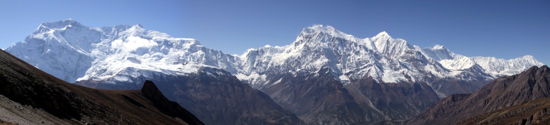
Luckily, the awkwardness of the terrain was matched by the majesty of the view. The forested flanks of 2,390m Monte d’Oro walled the valley to our right. Up ahead, the silver face of 2,254m Pointe Migliarello rose like a snake’s head. We aimed for the broad pass of Bocca Muratello between the two mountains. As we climbed above the forest line, tangled copses sprouted from gaps in the slabs. At 11am, with about 400m still to ascend, we stopped for our first lunch, leaning back against a comfortable rock and gazing back down at the valley and the thinning forest far below.

Towards the top of the pass, the direction of the paint marks slanted more gradually across to the left, traversing the slopes. Just before the pass, a pockmarked slab angled directly upwards and we raced up it, using our shoes for friction. Back in May, long before we even knew we were coming to Corsica, we climbed the Dubh Slabs, an iconic scramble on the Isle of Skye. It turned out that was perfect training for the GR20.
We crossed the 2,064m Bocca Muratello at 12.30. To our right was a fine ridge-walk up to the mitred summit of Monte d’Oro, a trail that I would like to complete someday. We could see the Bergerie de l’Onda far below us in a grassy clearing just above the forest. We had another 700m to descend to reach it, but the terrain was much easier on the northern side of the pass. We descended a grassy ridge on a trail through scrubby gorse. Towards the bottom, the path was badly eroded, in need of repair and fanning out like a four-lane highway. Besides the paint marks, some of which were fresher than others, I don’t think the GR20 gets much trail maintenance.
The ridge curved slightly to the right and we reached a saddle at 2pm. The bergerie was hidden from view, but we worked our way around the rim of the saddle to find a path down. We arrived at the bergerie at 2.15. The campsite was a single rectangular field, fenced off from sheep. The northwest flank of Monte d’Oro towered overhead, but the sun had moved to the west and the campsite basked in its warmth. The man at reception told us to choose any tent, so we grabbed a large 3-person one, hardly believing our luck.
Dinner was chaotic. The Bergerie de l’Onda turned out to be the GR20’s answer to Fawlty Towers. There was an elaborate dining system that involved taking a ticket to reception and getting a plate and cutlery before finding a place to eat. The staff spoke only French; many of the international clientele had no idea how the system worked and loitered in the dining room wondering what to do. I was innocently following Edita to a table when an elderly member of staff (whom I will call ‘Basil’) grabbed hold of the plates I was carrying and wrestled them onto a table opposite a random stranger. When I protested that my wife had gone to sit in another place, he wouldn’t let me join her. I glanced at the stranger, who kept quiet and looked terrified.

The incident was comically weird, but there was more to come. We eventually found a place with the Australians. Alison told us that the people in the tent next to them had been ‘projectile vomiting’.
‘I hope that’s no indication of the cooking,’ she said.
As we waited to be served, I went to buy a pichet of wine. I was told to get glasses from a shelf in the dining room. The glasses were a bit smudged; a sign said to clean your glass after use. The nearest washing area was 200m away on the opposite side of the campsite.
The first course of soupy stew was unexpectedly tasty, and we happily mopped our plates with bread, unaware that this was the only cleaning they would get. The plates were taken away and brought back with cheese lasagne; but we were horrified to see that they hadn’t been cleaned. Had they given us back our own plates or somebody else’s? We had no way of knowing.
‘If we were back home, this place would be closed down,’ I said.
‘Try not to think about it,’ Alison, who was a nurse, replied.
Even so, Liam and I did think about it, and left the bottom centimetre of our lasagne lining the plate.
Despite the dubious hygiene, the food was quite good, and the 3-course meal was rounded off with carrot cake. After dinner there was an enormous queue for the campsite’s one and only toilet. We spotted the Danes returning from another direction. They told us they had ‘been to the woods’, which we gathered was a Viking euphemism for a bear’s bathroom. It was now dark, and we snuck away to the trees behind camp to follow their example.

Somewhat unexpectedly, we woke the following morning in full health, with no inclination to projectile vomit. At breakfast, a British group who were walking north to south told us that the facilities at Onda were the worst they’d encountered on the trek so far, which was good news for us. We didn’t tell them about the pasta at Usciolu.
There were two possible routes from Bergerie de l’Onda to the campsite at Refuge de Pietra Piana. The standard GR20 route descended into the forested valley below the bergerie before turning left up another forested valley to Pietra Piana. But the alpine variant went up the other side of the saddle we’d descended into the previous day. From there it followed a ridge across two more summits before dropping to Pietra Piana from its lofty perch. It was actually shorter than the low route, with less ascent and descent, but the views would obviously be grander. It was a no brainer to take this higher route.
In fact, it was a short day, but it was some of the best walking and scrambling of the trip. We left at 8 o’clock and climbed back to the saddle, then began a long ascent up a grassy hillside on eroded slopes. It was a long slog, but it was far better terrain underfoot than the boulder hopping that we’d done the previous day. We progressed at a slow plod, pausing regularly to hydrate and admire the view back to Monte d’Oro and the Bocca Muratello.
We were rewarded at the top of the climb as the trail bent left to contour beneath a grassy ridge. We could now see Corsica’s western coastline and a town on the coast that was probably Ajaccio, where we started. We passed a flock of sheep grazing below the ridge, and reached a rocky pinnacle which marked the point where the ridge descended to a col in a comb of pinnacles. The trail dropped to the right of the ridge to bypass these obstacles. There was some easy scrambling to get off it, and we hurtled down, racing past the three young Parisiens we’d been leapfrogging since Col de Verde in a blur of rock dust.

We skirted beneath the pinnacles to reach the col before climbing steeply up to another peak. There was more scrambling, but again it was easy and not exposed. Edita wanted to stop for lunch at the top, but the summit was literally a bed of sheep droppings. We named the peak Monte de Merde de Mouton. The profusion of excrement all along the ridge meant that we were forced to have lunch on a rocky shelf just big enough to sit down on, but far too exposed for a sheep to use as a toilet. We had bread, cheese and saucisson overlooking bandit country. Mile upon mile of maquis covered the peaks and valleys between ourselves and the coast.
I expected an easy descent to camp, but the final section traversed around the side of a cliff face, and involved the most exposed scrambling of the day. Edita described it poetically as the approach to a mountain fortress. She even thought that it merited chains.
Pietra Piana was a spacious campsite spread out among thickets of spiny broom. It had the cleanest showers of anywhere we stayed, and we were delighted to secure another 3-person tent. A covered al fresco dining area overlooked the forested Manganello Valley that most of the other trekkers had ascended to reach camp. We spent a relaxing afternoon tucking into French fries and saucisson and chatting to our friends as they arrived in camp.
The third day out of Vizzavona (if you are travelling north) is one of the highlights of the GR20, crossing a high mountain cirque, walled by towering spires and dappled with lakes. Our trip notes predicted a 6½-hour day, slightly longer than other days but still short in real terms and not enough to change our plans in any way. It caused many people to think about leaving early, though; there was a rumour that the Australians were intending to leave at 7 o’clock.
‘7 o’clock, my arse,’ I said to Edita as we were settling in for the night. ‘They won’t leave at 7 o’clock.’

I was surprised when I unzipped the tent a few minutes after 7am to see Ramon and Petra disappearing into the undergrowth on the trail out of camp. I was even more surprised when I climbed out of the tent to see the Aussies about to follow.
‘Fuck me,’ I said, before I had chance to stop myself.
‘You weren’t expecting to see us up so early?’ Andrew said. ‘See you when you overtake us.’
In fact, most of the people in camp seemed to have departed already. The camp felt deserted. Those with their own tents had packed them away, and only a handful of people were taking breakfast with us.
We left at 7.45 and saw no one else for the first hour as a rough trail ascended through broom thickets on the hillside above camp. Behind us, we could look back and see the ridges and peaks we had traversed the previous day, with Monte d’Oro rising at the back. We reached a high shoulder; the trail rounded a corner to the right and became less steep. We could see the first pass, 2,210m Bocca Muzella ahead of us. We reached it at 8.45, after only an hour of walking.
We were now looking out into a high mountain sanctuary. We followed a trail to the left, beneath a ridge on a ledge of rocky slabs. Soon the path dropped steeply over boulder fields, and we could see the route before us skirting to the left around the rim of a rocky cirque. On the far side, 2,313m Punta alle Porte formed the high point of a red mountain wall. Every point of the wall looked sheer. Somewhere to the right of Punta alle Porte’s summit was the Breche de Capitello, at 2,220m, one of the highest passes of the GR20. From where we stood, any sort of crossable pass among this wall of rocky spires looked improbable, but we had to assume the terrain was easier than it looked.

Having already overtaken the Aussies soon after Bocca Muzella, we passed Ramon and Petra on the rim of the cirque. They warned us there was a group of about 100 soldiers on training manoeuvres up ahead. We caught the first of them when the trail became a scramble beneath the crest of a ridge. They were of many nationalities and ethnicities, some white, some Asian, some black, others of Latin appearance. One didn’t understand Edita when she spoke to him in French. We learned later that they were members of the French Foreign Legion.
They were all carrying assault rifles, as I guess you would in a combat situation. In the United States, I understand this is normal, but it was the first time I’d come across it on a mountain ramble since I hiked the Annapurna Circuit in 2006 during the height of the Maoist insurgency. As I took a parallel line below them, I did wonder if it was humiliating for a soldier to be overtaken by civilians. I considered holding my hands up and saying, ‘don’t shoot!’ but I decided that it’s best not to joke with a group of men carrying assault rifles. Luckily, they were courteous and seemed happy to let us past. One of them even halted his comrades as we skirted by.
We overtook another group resting beneath a gendarme on the ridge. We were just in time. A little beyond this we reached the chain that our route notes had warned us ‘might cause a jam’. I’d been hoping to reach this chain at a quiet time, but we had arrived at the worst possible moment. As well as the army behind us, there were many people coming down the chain towards us.
The chain was attached to a 20m wall of rock with many hand- and footholds. It was terrain that many people could climb without any aid, but the chain funnelled everyone together and ensured they could only move in one direction at a time. There were several hikers making a painstaking descent when we arrived, and it seemed likely that we’d have to wait a while for them. I spied a chimney to the left of the chain that looked like a nice scramble. I headed up it without pausing. There were a couple of moves where I needed to hoick myself up with my arms, but the handholds were good and I soon emerged at the top, having bypassed the chain. Edita was right behind me.

We found ourselves on a platform overlooking Lac de Capitello, the second of the black lakes. It would have been a fine place to stop and admire the view, but with the army right behind us we didn’t want to lose our hard-earned advantage, and we pressed on. The final section up to the pass, that seemed improbable from the opposite side of the cirque, turned out to be a rough scramble over a series of boulder fields. The pass itself, Breche de Capitello, was a narrow gap between rock towers, presumably the gateway that gave its name to the nearby peak of Punta alle Porte.
The pass lay at the top of a rubbled hillside. There were many more soldiers sitting there having a rest. Edita wanted to take a summit video, but I’m wary about taking holiday snaps with soldiers in uniform. There was so little space that it was hard to take a picture without a soldier in the background. If identifiable photos of soldiers find their way onto Facebook, then I imagine they present a security risk. My camera had been firmly in its bag for much of the last hour. I faced away from the pass and took a landscape image back across cirque, making sure there was nobody in view. Then I turned, and we headed straight down the other side.
If anything, the 600m descent to Refuge de Manganu was even rougher, over loose boulders for much of the way. It would be awful to ascend, but we went down in little more than an hour, including a stop for lunch when we reached the vegetation zone. The lower part crossed some grassy meadows that would have made pleasant wild campsites.
Just before we reached Manganu, there was a nasty moment when I took a tumble while racing across a narrow crack in a sloping slab. The slab was so smooth that I knew immediately I wouldn’t be able to prevent a fall. I faced outwards and tried to sit down. This, it turned out, was the best possible mode of recovery as I slid gently to the bottom, reaching safety long before Edita. Had I been more quick thinking, I could even have descended going, ‘weeeeee!’

‘Well, that’s the easy way down,’ I said when I landed.
I had somehow managed to survive a 3m fall with nothing more than a slight friction graze on the palm of my right hand, something I expect many of you suffered frequently as teenagers.
We reached Refuge de Manganu at 12.45, almost exactly five hours after leaving Pietra Piana. It was one of the most relaxing campsites of the GR20, set among greenery overlooking a junction of wide, rolling valleys. A river ran through camp. It was a far cry from the severe terrain we had passed through to get there. All of the tents were 3-person ones, which meant that for the third successive night, we had plenty of space. At dinner time, we sat at a picnic table on a hill just above the main refuge building, as a dimming sun bathed the campsite in a tangerine glow.
It rained on and off through the night. It was still dark when I heard people packing to make an early start. Those crossing the Breche de Capitello had a longer day ahead of them, but it was going to be an easy day for us, so Edita and I were in no hurry to pack up and hurry away; .
Many people had already left by the time we had breakfast, though nobody from our group. The rain continued to tank down on the roof of the veranda after we finished eating, so we relaxed and bided our time. Just before 8.30, the rain slackened. Edita and I spotted our opportunity. We brushed our teeth and donned our wet-weather gear. A Dutchman called Caspar laughed at me when he saw me putting on sun cream.

We were away before the others for the first time on the trek. The previous evening, we were joined for dinner by a pair of sporty twins in their early 20s called Tim and Ellie. Edita has a twin brother of her own, so she felt an affinity for them, but this morning it was a different story. The trail descended northwards to a grassy plain and we walked along briskly. As Edita stopped to put away her coat, I glanced behind to see the twins not far behind and rapidly gaining on us.
‘Let’s see if we can stay ahead of them,’ Edita said.
For the next two hours, she set a punishing pace, determined not to let the young whippersnappers overtake. The path climbed again as it crossed a hillside to head west. Soon we were in a high, wide valley surrounded by rolling hills. For once, the path was superb: flat as a pancake and the best we had found on the trek so far. A distinctive peak, Capu a Tozzu (2,005m), rose ahead of us in the form of a perfect isosceles triangle. Three playful horses galloped backwards and forwards across the plain. They came very close to the path, much to the delight of all the trekkers passing through. We could see the twins a short distance behind us, and Edita galloped herself to keep ahead.
We overtook two elderly Frenchmen as the trail passed to the right of a shallow lake, Lac de Nino. At the far end there was a junction of trails. The GR20 branched left and started climbing up to a pass, Bocca a Reta. We could see that two trekkers ahead of us had blithely continued straight on. They turned and followed as soon as they noticed us heading up the hillside above them. We now had three groups chasing us. I was reminded of the scene from Butch Cassidy and the Sundance Kid when Paul Newman and Robert Redford watched the dust cloud from their pursuers on the plains below.

Edita sped on. The Bocca a Reta lay a short distance beneath the summit of Capu a Tozzu. On another day I would have been tempted to climb to the top, but with the mad pursuit going on behind us, we didn’t stop to think. The GR20 skirted to the left of the peak on a fine airy path with the north-west coast of Corsica not far away. Beyond Capu a Tozzu, it turned into a craggy ridge before diverting to the right to take us down into the forested Niolo plateau.
We followed the ridge as it curled to the right and dropped to the plateau. Many people were coming up the other way, day hikers with smaller packs. After a steep descent of a bare, grassy ridge, the path plunged to the right into forest. The final hour of the day contoured a hillside among the trees. At about 12.45, after just over four hours of continuous walking, the trail rose steeply, and we emerged from the trees to arrive at the smooth, tarmacked surface of a road.
Just to the left, across the road, was a monstrous flat-roofed building, painted yellow and streaked with brown where the balconies came round the side. It looked like a marble cake. It was our hotel, the Castel de Vergio, and I was disappointed. I was half-expecting an ancient castle rising from the forest; instead, it was the sort of modern carbuncle you can find in any ski resort. It was a far cry from the delightful boutique hotel we’d stayed at in Vizzavona.
We had experienced some strange house rules on the GR20, but Castel de Vergio took the biscuit beyond a place where biscuits should ever go. The hotel foyer had lockers rather like a gentlemen’s changing room. We were told to put our rucksacks, shoes and sleeping bags inside one. The lady on reception explained that it was to prevent us taking bedbugs from the GR20 into our room. As she did so, she popped a grey wristband over my wrist and sealed it tight.

‘What bedbugs?’ I thought to myself. Then I thought: ‘What’s this — am I a guest or a prisoner?
I must have looked perplexed. ‘You must wear this for dinner,’ the lady said
We were made to unpack our rucksacks in the foyer. The receptionist gave us shopping bags to carry the rest of our things up to our room. My sleeping bag still needed an airing from last night. Had we been camping, this is the moment I would have draped it over the tent, but here I was in a smart hotel, being told to stuff it into a locker. I snuck both our sleeping bags into our luggage.
Meanwhile the twins, who had arrived soon after us and were staying in the bunkhouse, were permitted to take their rucksacks with them. Clearly bedbugs for bunkers was considered OK.
Resentment was bubbling as we walked upstairs. As soon as we reached the privacy of our room, I ripped off my wristband and hurled it onto the bedside table so hard that it would not have surprised me had I snapped the table in half.
‘I’ve never known anything like it,’ I said to Edita, ‘to treat guests from the GR20 like outcasts bringing in disease.’

It was a pity. Otherwise, the room was pretty good. It was actually a whole suite of rooms. We had a lounge with a sizeable balcony at the front, a double bedroom, bathroom and shower room at the back. Our room was at the end of the hotel, and must have been one of the few rooms with windows on both sides of the building. The only disadvantage of our position was that a side window overlooked the beer garden. As we chilled out in the room, we could hear the Australians socialising raucously outside.
There were stranger things to come later that evening. There was quite a nice restaurant with a wall of windows overlooking pine forest and an all-you-can-eat buffet; but a sinister undercurrent of segregation was in place. Only hotel guests with grey or green wristbands were permitted to dine there. Those staying in the bunkhouse had been given orange wristbands and had to eat in the crappy little refectory opposite. When I showed my broken grey wristband to a waiter, he steamed off to bar, returned with a stapler and literally stapled it back onto my wrist.
There was one final note of irony for the Danes, the only other people in our group who had splashed out on a hotel room. At 11 o’clock, just as they were turning in for some well-earned rest, they noticed that their beds were alive with creep-crawlies. So much for the elaborate locker system. Our room was fine and so was the bunkhouse. Luckily, the Danes were able to change rooms.
We had three more tough days ahead of us, but I was happy to leave the weirdness of Castel de Vergio behind. With our rucksacks confined to the locker downstairs, we were unable to pack in our room. We literally had to do all of our packing on the doorstep of the hotel. It was a restriction those staying in the bunkhouse — who were permitted to take their non-existent bedbugs with them into the dorm — were not obliged to submit to.

The others all left before us, except for Alison, who had been battling a knee injury for several days and decided the final three days were going to be too much for her. Edita and I bade her goodbye at 8.15 and wandered up the wide metalled road for about 100m to a point where the GR20 descended into woods.
It started off like every other day of walking. The trail dropped away from the road, then started rising again through forest. We passed Ramon and Petra shortly before the trail burst out of the forest and into a gorge. After an hour we passed another refuge, the Bergerie de Radule. It had a Nepalese teahouse feel to it, perching halfway up a hillside with an outdoor eating area. A surprisingly large number of people had stopped for breakfast.
The path circled around the edge of the gorge to cross a river, where we passed the three remaining Australians stopping for a rest. We kept going as the path swung back to the left and climbed more steeply into a high valley.
It was here that I noticed the first signs of trouble as Ramon and Petra started catching up with us again. We crossed a bridge and Edita sped off ahead. But I realised the Dutch were now much quicker than me and I let them overtake.

The path turned right into the broad green Golu Valley, a beautiful high sanctuary dappled with ever thinning outcrops of spiny broom. Up ahead were the distinctive rock peaks of Capu Tafunatu (2,335m) and Paglia d’Orba (2,525m), the first a compact clump of jagged spires fused together like a crown, and the second a sloping slab of red sandstone like a mini Uluru.
It was easy walking, but I was struggling in the sweltering sun as Ramon and Petra pulled away. Sweat was streaming from me in waterfalls as I stumbled along in the searing heat. I could see the next refuge, Ciuttulu di i Mori, high on a hillside at the end of the valley, and nestling beneath the wall of Tafunatu. The valley doglegged to the left and back to the right, but instead of keeping to the valley floor, the GR20 took a wide circle up the hillside to the left. It climbed steeply in zigzags on a stone-jumbled trail before following a high shelf above the valley to the refuge.
Beyond Ciuttulu di i Mori I could see that the trail continued its circular way beneath Paglia d’Orba and up to a col, Bocca di Foggialle, where it disappeared over the other side. But another trail led up to the same col from the valley floor. There didn’t seem to be anyone on this trail, but it looked a much more direct route than the GR20.
I was running out of energy and my stomach was churning like a cement mixer. Refuge Ciuttulu di i Mori lay in another wonderful location, commanding views back down the Golu Valley and sheltered behind by the walls of Tafunatu. We reached it three hours after leaving Castel de Vergio, which was the same time as our route description had predicted. I was surprised and encouraged to find the Danes and the twins were all still there. I’d expected them to be far ahead by now. Despite my poor performance, we were doing OK.

I collapsed by an outside wall. There was quite a lot of donkey crap around, but I didn’t really care. Edita went inside and returned with a massive prosciutto-and-salami sandwich and a tin of coke to help replenish my energy.
After 30 minutes of rest, we resumed our journey. I was slow up to the col, but it wasn’t far. Across the other side there was a short traverse between thickets of spiny broom. The trail between them was narrow, and we often had to wait for people coming the other way. There was a short scree slope that we descended rapidly. Then the trail plunged more steeply into the next forested valley.
There was a different type of rock to scramble over, lying in parallel vertical layers with many sharp edges protruding from its surface like daggers. People were struggling both up and down, but Edita and I were in our element. With gravity to help me, I found a second wind and we raced past each and every one, finding alternative routes among the rock strata.
We descended hundreds of metres of this jagged assault course before the trail flattened out a little. There were still a few razor-like extrusions underfoot. With the adrenaline rush of our steep descent behind me, I lost concentration. Yet again, time stood still as I felt myself falling. For several long seconds (or so it seemed), I hovered over the angry rock before my backside landed firmly on one of the skewers and I let out a yell.

Edita turned around. ‘Oh, my god. What happened?’
I waited a few seconds, but the pain that I was anticipating didn’t come. I stood up and rubbed the base of my spine. There was an uncomfortable bruise, but nothing worse.
‘It’s alright,’ I replied. ‘My arse bone landed on one of those nasty spikes, but I think I’m OK.’
A few moments later, we caught up with the twins taking a rest beside some rock pools. Edita said something to Ellie, who had studied biology at Oxford.
‘Ah, his coccyx!’ I heard Ellie reply.
This was more anatomically correct than my description, but catching one’s coccyx on sharp rocks sounds too painful to contemplate. We continued onwards, but a few minutes later there was a flash of blue as Tim raced past us on a steep section. Ellie passed in more leisurely fashion a little while later.
The jagged rocks finally ended when we entered forest and the GR20 became a trail again. It should have been easier, but in a bizarre twist, I found myself struggling for energy now that I no longer had gravity to help me. There were two to three kilometres of forest trail as the GR20 curved to the left and began climbing into the Ravin du Stanciacone, the gateway to the Cirque de la Solitude. This had been the crux of the GR20 and its most fearsome section, but it was closed after a landslide killed seven trekkers in June 2015. It’s now only permitted to cross the Cirque de la Solitude with a qualified guide. The GR20 has been diverted up another valley and over a shoulder of Monte Cinto, which at 2,706m is Corsica’s highest mountain.

We reached our night stop, the Bergerie de Ballone, at 2.45. The main refuge, Tighiettu, was a kilometre further up the trail. This meant that Ballone was a quieter campsite than almost all the other places we had stayed. It had a cosier feel, in a forest clearing some way up a steep, forested valley. All of the tents were spacious; they had proper mattresses instead of Thermarests, and we were even given clean sheets to put over them.
I was slightly confused when signing in for our tent to see three names listed before ours. I wasn’t surprised to see the Danes and the twins listed, as we knew them to be ahead of us. But the first name on the list was Andrew’s. What on earth was going on? The Australians were always slower than we were, and we had overtaken them much earlier in the day. They couldn’t possibly have arrived before us.
But a few minutes later, as I was unpacking my gear, I heard Andrew’s strident tones echoing across the campsite.
‘How the hell did you get here before us?’ I shouted across to him.
‘He cheated,’ I heard Ellie reply.
Andrew had noticed the path straight up to the col from the Golu Valley, that I had seen from Ciuttulu di i Mori, when he was looking at the map the previous evening in Castel de Vergio. He could see that it was considerably shorter than the route of the GR20. The Aussies took this path, and they were here well before us, despite being slower. It was a smart move. Nevertheless, they were Australian, and my lips released a caustic remark about ball tampering before my brain even noticed I was talking.

I was still under the weather and spent the afternoon lying on my back in the tent. It was annoying to feel ill on the night before the toughest day of the GR20. I had no idea why. Initially, I had put my illness down to the 1L pichet of vin rouge that I shared with Edita in Castel de Vergio, most of which had ended up in my glass rather than hers. Until then, vin rosé (see my previous post) had been our staple, which is a little lighter. But the effects of last night’s booze should not have lasted all day.
Space was at a premium in the restaurant that evening, so we sat outside on the balcony, hunkering down in thick coats and beanies. On the plus side, the food was of a higher quality here: a good spread of cold meat and cheese for starter, and a decent veal pasta for the main. Our diet was lacking in greens, though. Was this the reason my stomach was protesting? For the first time on the GR20, I restrained myself from alcohol. I very much hoped my temperance would stand me in good stead for the following day.
With a longer day ahead of us, Edita and I agreed to set the alarm for 6am to try and get away as early as we could. It was still dark when the familiar beeps started sounding, and we could hear many shuffling sounds from nearby tents. There were about a dozen people in the restaurant at breakfast, and many had left already. There was no sign of the Australians.
We left Bergerie de Ballone at 7.15, an hour earlier than usual. We were pretty much the last people to go. Our trip notes said the traverse of Monte Cinto would take about 8½ hours, but we had a hotel night at the end of it all, which meant there was no rush.

The first half hour was a little tedious. Many people had just left Refuge Tighiettu, a little further up the trail, and were descending in our direction. We left the forest almost immediately and headed out onto rocks. Dwarf trees clung to life high in this otherwise desert-like landscape. The trail was awkward as we ascended through the last remnants of the forest.
Refuge Tighiettu was set in an unlikely location, perched high on a shelf. We reached it in half an hour. Here, the GR20 left the Ravin du Stanciacone and diverted beneath the refuge up a side valley to the right. We were suddenly on our own, a rare period of solitude on the GR20. There were sections of walking on rocky ground, and there was an abundance of scrambling, much of it across steep slabs. We made good time, but the only person we overtook was an Englishman who looked like the comic actor Karl Pilkington, whom we had been meeting on and off since Manganu.
We left the rocks and climbed an energy-sapping scree slope for the final section up to the first pass, Bocca Crucetta. Technically the terrain was easier now, but as it had done yesterday, my pace ground to a crawl, and every time I looked back I could see that Karl Pilkington was slowly catching up again.
We reached Bocca Crucetta (2,456m) at 9.45 — on schedule, according to our route notes. Here we caught up with Ramon and Petra. According to the notes, there were still another two hours of walking from Bocca Crucetta to Pointe de Eboulis (2,607m) — the highest point of the GR20, and just 99m shy of the summit of Monte Cinto. Earlier in the trek, we had discussed making a short diversion to the summit. But after reading the route description in Paddy Dillon’s Cicerone guidebook, and knowing that it was going to be a long day even without bagging the summit, I went off the idea. Now that I wasn’t feeling 100%, it was even further from my thoughts. On top of this, rain was predicted for the afternoon, making scrambling more hazardous.

On the more encouraging side, Pointe de Eboulis looked very close. We could see a rubble-lined ridge curve away from us to a point with a large summit cairn and cross. There was a short scramble down off Bocca Crucetta, then a horizontal scramble across slabs just to the right of the ridge crest. The route looked down into an enclosed combe, just big enough to accommodate a turquoise lake, Lac du Cinto. Edita and I raced across the slabs, but slowed down again when we reached the rubble. From there it was another slow plod.
We reached Pointe de Eboulis at 10.45, far earlier than we expected. The highest point of the GR20 was very busy. There were 20 or 30 people, some of whom were packing away a tent, as though they had camped on the summit. We caught up with the Australians here, who told us that many people were leaving their bags to go to the summit. Jakob and Tim had already gone, and Andrew was intending to follow. I looked across at the highest point in Corsica, a protruding rock tower some distance away. I knew that it was 2-hour diversion there and back, involving some tricky scrambling. We were making good time. Would it be tempting fate to go to the summit now?
I looked at our trip notes, to try and get an idea of what the descent held in store, but they were as laconic as Harpo Marx.
‘The trail drops down to the Lac d’Argentu. Take your time; it is steep and the rock is loose.’ (1.5 hours, 1km)
Then:
‘Continue downhill, following the trail into the Rav du Tighiettu.’ (1.5 hours, 2.5 km)
That was it. Three hours of walking/scrambling/climbing/flying (delete, as appropriate), compressed into three short sentences.
I inferred that the first part was tricky and the second part less so, but what did it really tell me? Not a saucisson. At that moment, Edita was stronger than me, so I decided to let her make the decision.
‘Do you want to climb Monte Cinto with Andrew?’
‘Not really. We can come back and bag the summit another day,’ she said. She was probably being kind to me, but I took her at her word.

After a short rest and a sandwich, we continued over the pass and down the other side. It was a good decision. ‘It is steep and the rock is loose,’ was certainly accurate. We were descending the main route of Corsica’s highest mountain. It had seen plenty of footfall over the years. Thousands of tramping boots had produced a horribly eroded scree slope with multiple diverging trails. The scree had been ground to a fine powder on top of bare rock.
Such slopes are tedious, rather than dangerous. As long as you’re sure footed and confident, it’s possible to race down them. But if you’re not, then great care must be taken. Today, I was somewhere between the two. It took about an hour to descend the steepest part, past a lake, and reach a place where the trail turned left and flattened out above a high valley.
We stopped for another snack and sat among a jumble of boulders. Below us, an unlikely trail made its way down a sloping shelf, high above a deep gorge. The line ‘continue downhill, following the trail into the Rav du Tighiettu’, did it no justice whatsoever. The same description would work for the stroll down Primrose Hill into Regent’s Park. But this was an astonishing airy path; it had many sections of scrambling high above a gorge whose bottom was so far beneath us that we couldn’t see it. Vertical cliffs of swirling red granite towered over us to the right. It was a far longer and more committing section than the monotonous scree slope below the summit.
As the gorge worked its way around a corner to the right, we encountered several thick chains. Most of these we didn’t need to use, but there were a couple I decided to put my hands on. At one point the trail doubled back down a ledge to the left, but Edita took her own direct route over a cliff to the right. I kept to the paint marks, which took me on a slanting traverse down a crack between rocks. A long chain lined the crack and I followed it. At the bottom I had to scramble back to the right to reach the base of Edita’s cliff. When I reached the bottom, she was nowhere to be seen and I became concerned, but she soon appeared at the top of another rock step.

Relieved, I sat down and waited on a rock, but a minute later she was still there and I heard her plaintive cries.
‘Mark, Mark.’
I climbed back up to help her, but when I reached the base of the cliff, she had already managed to find a way down. By the time we crossed a footbridge at the bottom of the gorge, we had lost much of the time we had gained earlier in the day. I wondered if the person who wrote our trip notes had ever done this section of the GR20. Had they simply copied-and-pasted it from somewhere, or were they just lazy?
There was another 45-minute walk along one of those contouring trails through forest we had become accustomed to. I caught the occasional glimpse of a vehicle on a tarmacked road somewhere beneath us. I was pretty tired when we emerged into a sloping car park at the ski resort of Haut Asco. We caught the welcoming sight of a long restaurant balcony, and we could see the Danes and the twins taking refreshments. It was 3pm; the longest day of the trek had taken less than eight hours.
Dinner that night was slightly bizarre. We were given designated seating again in a cosy hotel restaurant. But this time, we had all been split into our respective groups. We were the first people to arrive; for the first ten minutes we conversed by shouting across an empty room. We were served exactly the same food as we had eaten in Ballone the previous evening — penne with veal and no vegetables. Perhaps it was the leftovers. Edita and I shared a bottle of rosé, but by the time we got to the coffee, my stomach had resumed its protest. Back in the room a few minutes later, I brought most of the penne back up into the sink.
We had just one more day to go, a short ascent of a pass and an easy walk down to the roadhead at Bonifatu. I hoped there wouldn’t be too much scrambling. I enjoyed scrambling, but you can have too much of a good thing, and the GR20 had certainly given me that.
But there was one last twist in the tale. It was going to be a day that I would never forget.
To be continued…
You can see all my photos from our trip in my GR20 Flickr album.


I suppose a cliffhanger is only appropriate on a climbing blog!
Seriously, I hope your illness was short-lived, and health returned quickly.