
Exotic locations often have dubious superlatives applied to them, sometimes with little or no attempt at verification. The highest, the biggest, the oldest, the longest, the deepest: you see it all the time when you’re travelling. The highest pass and highest lake are two examples I’ve seen applied to various features that probably wouldn’t even make it into the top ten of their true lists.

When travelling in Ecuador, I was frequently reminded that Chimborazo, the country’s biggest peak, was also the highest mountain in the world when measured from the centre of the Earth – a distinction it earns by virtue of being close to the Equator, where the Earth bulges more than at the Poles.
While happy to go along with it for a bit of fun, I took this claim with a pinch of salt. How the heck does anyone know the distance of mountaintops from the centre of the Earth?
That’s why I was delighted to come across this:

“What the bloody hell is that?” I expect you’re thinking.
There have been accusations over the years (in part due to the quality of my jokes) that this blog is sometimes a bit low-brow.
So for those of you who think my blog is low-brow, put this in your pipe and smoke it.
This, my friends, is the formula that proves mathematically that the summit of Chimborazo is indeed the furthest point on the Earth’s surface from its centre. I found it on a marvellous website called the Math Encounters Blog, which uses maths to answer all manner of quirky questions. The blog’s author, Mark Biegert, has gone to the trouble of feeding into the above formula the latitude coordinates of 200 mountains over 5500m from GeoNames, a publicly-available global database of place names.

GeoNames lists Chimborazo as being 6268m high. This is at the lower end of Chimborazo’s various disputed altitudes (the most commonly quoted figure is 6310m). This is good enough to convince me that it’s indeed the highest mountain in the world, but if I wanted to be more certain there was one more thing I could do: climb the mountain myself and measure its altitude with a handheld GPS.
And if you read last week’s post about my Ecuador peak bagging extravaganza, you will know that’s precisely what I intended to do after I climbed Cayambe (which, incidentally, is the 8th highest mountain in the world according to the Math Encounters Blog).
And so, earlier this month I found myself driving along a winding mountain road in the heart of Ecuador’s Central Highlands with Edita and our guide Romel. The road was much better than the pitted dusty one which had taken us to the hut on Cayambe. This one was metalled, and rather than crawling up the side of a mountain, it passed through wide open spaces on a high plateau. Apart from the change of vegetation from lush grasslands to sandy desert, we might easily not have noticed we were over 4000m already.

The only splashes of green were knee-high chiquiragua bushes, a hardy plant that grows a startling orange flower. The bush provides good nourishment for vicuñas, the rarest of the four species of the South American llama family. The plateau was teeming with them, and they have become quite accustomed to vehicles tearing past.
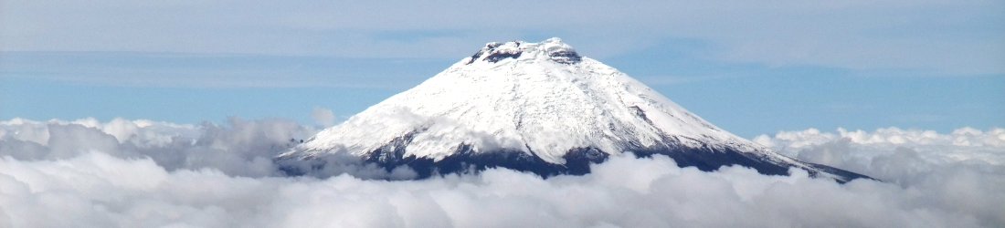
The mountain looked very dry as we approached Refugio Carrel from the west, our base for the climb. The hut stood at 4800m at the very top of the plateau. As had been the case on Cayambe, the presence of a road right up to it meant there were many day trippers when we arrived, though very few actual climbers.
From Refugio Carrel the west face of Chimborazo resembled Jupiter’s spot, so bare was it of snow that the rock had become a swirl of red in many different shades. Two ridges led up the mountain either side of the face. The ridge on the right was the one Edward Whymper and the two Carrels (Jean-Antoine and Louis) took on their first ascent of the mountain in 1880. I recognised features from the photos in Whymper’s book, but the route ended at a sheer cliff that had been a ramp of snow in those days.
We would be taking the ridge on the left the following day – or to be more precise, later that evening. I complained last week about the early start we made on Cayambe, which led to us completing the entire ascent in the dark and returning to the hut while it was still early in the morning. On Chimborazo we would be leaving even earlier, but I knew it was going to be a much longer climb.

In fact, it’s the earliest start I have ever made for a summit climb in my life. After a 5.30 dinner we settle down in a 12-bunk dormitory with some old Russian friends from the operator 7 Summits Club, whom I climbed Elbrus with in 2012 and who happen to be climbing Chimborazo too. We try to snatch what sleep we can.
I am woken by the shine of Romel’s head torch at 9.30pm and we go downstairs to force down some breakfast, although it seems like we’ve only just eaten. There are roughly 20 other people heading for the summit, and most of us are leaving at around the same time. We leave the hut at 10.45, and walk in darkness along a flat dusty plain for about ten minutes to reach the base of the West Ridge.
For several hours we trek steadily up the ridge, climbing hundreds of metres without breaking sweat. It’s an easy climb, but the wind bothers me a little. I know it will be a cold summit day if we can find no shelter from it, but Romel seems unconcerned.
Sure enough, towards the top of the ridge we traverse underneath the rock towers of El Castillo, a prominent feature that we could see from the hut, and the wind drops. In the darkness this section of the climb feels like an exposed scramble, but in reality it’s a clear path.
We catch up with other climbers at the far end of El Castillo. The altitude is 5450m and although we are not yet at the glacier, Romel suggests we put on our crampons in the shelter of rocks.
The next section is horrible, an exposed dusty traverse up a ridge. The wind whips up dirt, and I frequently have to put a gloved hand over my face to prevent grit being thrown into my eyes and mouth. Soft pebbles roll beneath our feet, and our crampons help to gain purchase. There is one section of scrambling up a rock wall, but the soft stone crumbles in my hands and I can’t trust a single hold.

The ice begins imperceptibly at 5650m. It’s possibly the most atrocious ice I’ve encountered in my life. Dry, crumbly and steep, a type that will be difficult to arrest on in the event of a fall. In the darkness it feels dangerous, but we press on. I can worry about the descent when the time comes.
The steepness and conditions are relentless, but there is a measure of release when daylight arrives at 6am. The clouds are far below us, and the twin summits of Iliniza poke up to our left. Behind us the shadow of Chimborazo’s summit is cast across clouds to the west.
There is a nasty section of penitentes as we approach Cumbre Veintimilla, the lower of Chimborazo’s two main summits. These ice pinnacles are formed by sun and wind, and it is difficult to negotiate a way through them. They are far worse than the ones many climbers become familiar with on Aconcagua. Most extend well above our heads, and the passages in between are narrow. Frequently we have to climb up onto ledges and find a way across into parallel passages. It’s not easy terrain to negotiate, and very tiring.
Just before 7.15 we meet a team coming the other way. Their guide congratulates us, and a few moments later we step onto Cumbre Veintimilla, a few metres lower than Cumbre Whymper, the true summit which is supposedly just a short hop away.

There is a magnificent view to the north. Cotopaxi, Cayambe and Antisana rise up in a line above the cloud. All are distinctive volcanoes from this angle, though Cayambe is more distant and rises timidly between the other two.
We stop for a rest. Another rope team arrives, and again their guide congratulates us. It’s premature, and I tell him so.
“We’re not there yet,” I reply.
Cumbre Veintimilla, Chimborazo’s second summit, is not very distinctive. Sure, the ice drops slightly on the other side, but it rises again to the obvious higher point of Cumbre Whymper which we can clearly see a short distance away.
Both summits are entirely covered with the almost impenetrable maze of penitentes which began lower down. I am already very tired, and I know it isn’t going to be easy to negotiate a way across to the main summit.
I don’t realise that for many people Cumbre Veintimilla marks the climax of their climb, and they have no intention of going any further. We don’t consider stopping for one moment. The job is not yet done, and it’s inconceivable for us to turn around so close to the top.

We unrope for the final section, and after a short gulp of water Romel leads the way onwards. I’m surprised to discover there are no wands marking the route from Cumbre Veintimilla to Cumbre Whymper. Romel has to find a route through the maze himself, and I wonder when was the last time that anyone else came this way.
At one point he reaches a dead end and stares across snow walls from an icy turret with no way down. We backtrack a short distance, and another guide catches up to help with the route finding. It’s demoralising seeing the maze ahead of us and knowing we may have to retrace our steps at any moment. The sun beats down mercilessly, sapping our strength, if not our resolve.
Although there are several people behind us, only half a dozen of them choose to follow us across to the true summit. Slowly Romel and the other guide make progress, cutting a way through with their axes. As we rise towards the summit, the penitentes field becomes a catacomb of ice.
It’s picturesque and intricate, but I’m less inclined to appreciate its natural artwork than I should be. The walls are softly melting in the snow, and several times I lean against a wall only to see a piece of it break off. It’s slightly irritating, and I try to remember my sense of humour, which must have hidden in a crevasse while I was becoming too exhausted to notice.

Suddenly we are on the summit, an elevated platform above icy trenches. We see three new mountains. Two of them, Tungurahua and Sangay, are highly active conical volcanoes. Although neither are erupting at this moment, their frequent ash clouds are partially responsible for the horribly dry ice conditions we have encountered here on Chimborazo. Rising up between them is the crinkled rock fortress of El Altar, which has a reputation for being Ecuador’s most technically-difficult peak. It has nine summits, all of them rock climbs.
I take a summit video, and when the guides hear me describing Chimborazo as the highest mountain in Ecuador, they protest in unison.
“No, the highest mountain in the world!” says Romel.
“We are closest to the sun!” one of them cries.
I remember to take a GPS reading, and it hovers in the region 6284 to 6287m. It’s hardly going to set the record straight about the true altitude of Chimborazo, but it’s good enough for me. Thanks to the Math Encounters Blog, I now believe Romel is right.

We stay on the summit for half an hour, and unlike on Cayambe where I shivered for 45 minutes, it is relatively warm. This causes problems when it’s time for us to return to Veintimilla. It’s comfortable enough descending off Cumbre Whymper, but soon we are fighting through penitentes in sweltering heat once again.
It’s exhausting to climb back up to Cumbre Veintimilla, and I’m glad to get it over with. I flop down in the snow, knowing that the final bit of ascent is over at last. It’s 10am and it has taken us nearly three hours to traverse between the two summits. I begin to understand why so many people, the majority it seems, stop at Veintimilla. Romel tells us it’s likely nobody would have ventured to Whymper today had Edita and I not been so determined to reach it. Once they saw us struggling our way over, a handful of them followed.
Despite the extra effort, for us there was never an option. The ice was atrocious but the weather was good, and we knew we would never have a better chance to reach the furthest place from the centre of the Earth.

We steel ourselves for the descent, which is going to be tough. We are the last of three rope teams to head back down, and the others leave us far behind. We were one of the strongest rope teams on the way up, but now we are the most tired. Perhaps we are still recovering from our ascent of Cayambe two days ago, or perhaps we are simply less confident on the shockingly dry ice, which lacks even a centimetre of recent snow. It takes us three hours to descend the Thielmann Glacier, and we take it very gingerly indeed in our desperation to remain on our feet.
The difficulties aren’t over when we reach dry land and flop down in the pebbled earth. I’m so tired that I lean over to retch, but I’ve eaten and drunk almost nothing and I splutter in vain.
We take our crampons off, but the ground is like a bag of marbles on a 40º angle. All three of us fall on our backsides within seconds of starting out again. When I fall for a second time and catch my backpack right in the curve of my spine, we decide to put our crampons back on again. Edita and I are extremely tired and it’s turning into a very long day, but I know we are in no danger as long as we are careful.

We reach the end of the pebbled ridge and take our crampons off to traverse beneath El Castillo. This section felt exposed in the darkness, and although a fall would be nasty, the path is broad and easy. Romel goes on ahead and we find him sleeping on a rock at the far end of the traverse.
The rest of the descent is on easy ground with no dangers. I’m the slowest and Edita waits for me while Romel returns to the refuge, his duty done. We finally hobble in ourselves at 2.30pm, after nearly 16 hours.
I feel like the walking dead, but there is a great sense of satisfaction. Now we can both say for sure we’ve climbed the highest mountain in the world.
Here is a short video of the climb to whet your appetite, and you can see all my photos in the Ecuador Flickr album here.
Of course, Chimborazo isn’t really the highest mountain in the world. That distinction goes to Everest. If you enjoyed this blog post then you may be interested in my book Seven Steps from Snowdon to Everest, about my journey from hill walker to Everest climber, out now as an ebook and shortly to be released as a paperback. You can sign up for my email list to keep updated.


Hi Mark,
liked very much the reading of this blog post, as well as your book Seven steps…..
If you enjoy volcanoes then it is a must to come to Argentina, where you will meet the highest volcanoes in the world: Ojos del Salado (6879 mts), Pissis, Lullaillaco (near the summit incas mummies were found), etc, etc
Moreover: beautiful and inmense landscape, good food and wine, historical places and cultures, and to last but not to least: very experienced and nice people to guide you.
See you
Thanks, Esteban. Yes, the Puna de Atacama has been on my to-do list for a few years now. One day I hope I will get there!
Pingback:Chimborazo — Part I – KRASSTIME