
This is the third in a series of posts about my recent visit to Ladakh in northern India, my first foreign holiday after the COVID-19 pandemic.
In my first post I described the start of my trek up the famous Markha Valley. In my second, I whizzed up 6,220m Dzo Jongo East. In this post I recount our attempt on the slightly (but only slightly) more technical Dzo Jongo West.
I woke up the morning after our ascent of Dzo Jongo East lacking enthusiasm for the climb ahead. We had been told by our guide Santosh to pack our jumars for the steeper sections. I hadn’t been intending to do anything too technical on my first return to the mountains, but perhaps I should have expected to.
I discussed the situation with Edita. I said I was happy just to trek and she said in that case she was fine with it. But I could see that she was keen to climb, and it would have been mean of me to drop out. In any case, I was the one who suggested that we climb two peaks instead of one, so I could hardly complain.

At our 8 o’clock breakfast, I discovered that Santosh and Imran had also been discussing my lack of enthusiasm, but they had mistaken it for a lack of confidence and were wondering whether I should continue. I reassured them I would be fine and we could go ahead with the climb.
After breakfast we took it easy for the next four hours as we got our stuff ready for the walk up to high camp. Edita and I would be carrying our personal kit, including sleeping bags and mats, shoes for high camp, crampons, axes and climbing kit. We gave the others our tent to carry. Tukten was coming with us to help with the load carrying, but then he would return to base camp.
The sun was out and we had a peaceful, leisurely morning sitting on camp chairs and looking up at the mountains. It was as relaxing as treks can be. While we were sipping tea, four Indian trekkers from the big group who had taken over our campsite passed by and we had a chat. We told them about our ascent of Dzo Jongo East the previous day. While we’d had a comparative lie-in and set off at 4.30am, they were intending to leave at 10pm that night. Their guides reckoned it would take them 8-9 hours, and they hoped to be on the summit around 6 to 7am. It’s an extraordinary way to do such an easy walk-up peak, but judging by what Santosh and Imran had told us about the speed of these enormous Indian trekking groups, such extraordinary precautions seemed necessary.

Once again Tukten cooked us a magnificent lunch of cheese spring something-or-others (they were the wrong shape for spring rolls), curried potatoes and salad.
We left at midday, equipment dangling from our backs like pedlars, and walked slowly up the hill above camp. Clumping along in my heavy mountaineering boots, I was much slower than the others and had to stop for a rest while camp was still in view. At the second stop Santosh was waiting for us. I made a joke about him promising Jamie, our expedition operator, that he would carry our kit. I don’t think he appreciated it. Our jovial crew were more serious now we were at the business end of the trip. They were having to work much harder and were less inclined to go along with my and Edita’s clowning around.
‘I hope you don’t mind me making jokes about load carrying,’ I said to Santosh when we stopped again much higher up. ‘Don’t worry, I won’t tell Jamie that you made us carry our sleeping bags.’
In fact, I didn’t mind the load carrying. Our bags were not super heavy and it was good exercise for us. But I wasn’t hurrying.

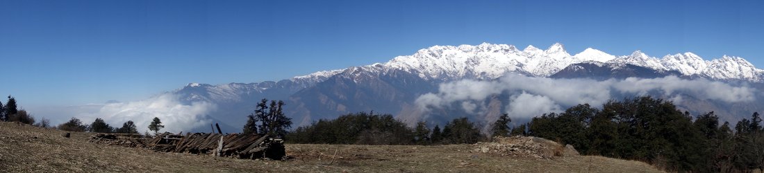
Gradually the grassy hillside turned more rocky and we emerged onto a plateau. We now had great views of both Dzo Jongos across a glacier and a third pointed peak to the right called Mallari Ri, which was joined to Dzo Jongo West by a separate ridge. We were at a height equivalent to the halfway point on yesterday’s summit ascent. We were clearly going to have a much shorter summit climb this time around.
We crossed the plateau. Kang Yatze’s main ascent route could be seen up ahead across a valley. We’d seen it a few times now from a variety of angles. It had never looked tempting to climb, and it didn’t now. To our right we could look out over the Nimaling valley to the Konmaru La and our peak of a few days ago (which I’d imaginatively named Konmaru La Peak).
At the end of the the plateau, we walked up onto a rocky ridge of moraine and followed it for some time, up and over more small hills, gradually climbing all the time. At one point, we crossed a short snow field and ascended again. It was a far more epic ascent to camp than I’d been expecting, but Edita and I were super happy because the higher we went today, the shorter our climb would be tomorrow. Down to our left was the glacier that led to the base of the two Dzo Jongos, and this little finger of moraine acted like a by-pass, taking us alongside it at a more rapid pace.

Eventually Tukten passed us coming the other way, having completed his load carry, and we knew that camp was near. We reached it in a brief squally shower. I had been fearing a long descent to the glacier — altitude that we would need to regain the following day — but in fact we descended only a few metres. Santosh and Imran were pitching our tent on a flattish area right near the edge of the glacier.
We were somewhere beneath Mallari Ri. We needed to skirt around its left-hand side, following the edge of the glacier to its end, then turn right up to the col between Mallari Ri and Dzo Jongo West. There didn’t seem to be any awkward barriers standing in our way — just a walk up a glacier, gradually steepening towards the col.
It was 4.15. I took out my GPS and was gobsmacked to discover that we were pitched at 5,800m. We believed the summit to be 6,280m, which meant that we had less than 500m to ascend tomorrow. I was delighted with our day.
Edita and I settled into our tent and made ourselves cosy and comfortable. This was the highest I had slept since I was on Peak Lenin in 2015, but I wasn’t feeling the altitude at all. I felt surprisingly good after climbing to 6,220m on Dzo Jongo East the previous day.

We discussed tomorrow’s departure time. With such a short ascent, we agreed that Santosh couldn’t possibly ask us to leave before 4am — we would probably reach the summit while it was still pitch dark. He popped his head into the tent a few minutes later and we repeated the conversation.
‘We don’t mind leaving at 4am,’ I said, ‘but if you’re prepared to leave later then even better.’
‘OK, then. 4.30,’ he said.
We cheered.
I was now in a much better frame of mind than I’d been when I woke up that morning. I was glad that we’d continued with our plan. I was full of hope for tomorrow. I might even enjoy it. I kept my fingers crossed that the weather was fair again, though I didn’t think even that would prevent us reaching the summit — unless there was a dramatic change on what we’d experienced so far.
What a stupid thing to say on the eve of a summit climb!

Everything started swimmingly. My alarm pinged us awake at 4am. Edita and I had most of our clothes on inside our sleeping bags. It was a cold morning, but not too cold. Even so, it took us a little time to get ready as we also had boots and harnesses to put on. We’d brought everything into the tent, including crampons in their bags, so that they wouldn’t get frozen overnight. (Of course, we didn’t put our crampons on inside the tent — that would be silly, and a sure way to rip the nylon. We just brought them in so they wouldn’t freeze too much.)
While we were getting ready, Imran came with tea and cake. He had a bad cough yesterday, but Edita gave him cough sweets and ibuprofen and he said he was feeling much better this morning.
With everything ready, I went outside to put on my crampons, the very last thing. It was a few years since I’d worn them, but my memory isn’t fading yet and I did everything correctly.
When we departed for the summit at 5.15, Santosh seemed surprised that Edita and I had our crampons on already. I was equally surprised to see that he and Imran intended to start without them. We were straight onto snow from camp — it looked like a glacier — so it seemed a no-brainer to put both our harnesses and crampons on in this easy location.

It was a clear morning. We could see the stars and both Dzo Jongo summits. Everything looked promising and I had every confidence we would be on the summit in 3 to 4 hours.
How wrong I was.
The snow was firm underfoot and we crunched along unroped. Santosh kept to the right, underneath the ridge of Mallari Ri which met the east ridge of Dzo Jongo West at a col. It felt like a glacier, but outcrops of rock suggested that perhaps we were still on solid ground. We kept beneath the mountainside until the glacier turned to the right to climb up to the col. Across the glacier to our left was Dzo Jongo East, which we’d climbed two days earlier, only a few metres lower than Dzo Jongo West and joined by a gently arcing ridge.
The walking was easy and we adopted different strategies as the terrain gradually rose. First we walked normally, stopping only occasionally for a drink. As the terrain steepened we changed our tactics, walking 50m at a time then pausing for a few breaths before continuing. Then, as we rounded the corner to the right and began the ascent to the col, the terrain became steep enough to adopt the ‘rest step’, pausing every stride for a single breath.
At around about this time we heard a loud whoop high over our left shoulders. It was about 7am and I assumed it was some of the Indian group reaching the summit of Dzo Jongo East after their 10pm start last night. If so, then it had taken them 3 hours longer than us. We could still see the summit of Dzo Jongo West above us and we assumed we wouldn’t be far behind them.
But things were about to change.

The glacier continued to steepen. I adopted the ‘Charlie Chaplin technique’ of walking with my toes pointing outwards. Then I had to adopt the ‘French method’ (a.k.a. the ‘Marcel Marceau technique’) of traversing upwards by keeping my feet parallel and stepping one foot over the other.
We reached a large outcrop of rock in the snow face and stopped so that Santosh and Imran could put on crampons. It was amazing they hadn’t done so yet. There was no way I could have reached that point without spikes on my feet. Edita and I had to stand in a precarious position with our feet planted on the slope, axes rammed firmly in as we waited for them.
This was the place where Santosh had been intending to put up a fixed line. However, it seemed they’d decided that Edita and I looked safe enough just climbing and we continued onwards unroped.
Safe we may have looked, but the next section was decidedly hairy. As the slope continued to steepen the ice became quite solid underneath, and it was hard to gain purchase with both feet and axe. We angled upwards on a long traverse, and I continued using the French technique, keeping the soles of my crampons flat against the ice, instead of driving the toes in and front pointing. But the slope was seriously steep and extra security was needed. I partly faced into the slope, banged the pick of my axe in rather than the spike, and rested my other hand on the slope for extra balance.

As for my thoughts, they were rooted firmly in the English technique of turning every available adjective into an expletive. The slope beneath our feet was far from being a smooth sheet of ice, gently concaved to slow any unplanned descent. It was peppered with rocky outcrops and there was one just a few metres below us. There was zero chance of arresting a fall in this ice as firm as plasterboard. Any slip and I would be dashed to smithereens.
I was mightily relieved to reach the safety of rocks just beneath the col where a shelf of horizontal ice led onwards, providing security from then on. The sky had clouded over now and we could no longer see the summit. A light snow began to fall.
The going became much easier after this, with a layer of snow on top of the ice, but the snowfall was gradually becoming heavier. Imran led the way up from the col, over a couple of hummocks and keeping slightly left of the ridge, which dropped away into cliffs on its northern side.
But the deep snow and easier terrain provided only an illusion of safety. As the snowfall thickened, so too did the mist. I could barely see Imran’s feet a few metres in front of me.
It was Santosh who first noticed that we were ascending into a whiteout. He called a halt.
‘Whiteout. Very dangerous,’ he said.

The landscape to our left contained no discernable features at all, and although the ridge was gentler on that side we couldn’t be sure where it ended. Meanwhile, the sheer drop to our right was marked by a dashed line of jagged rocks, but there were gaps in between that contained only a blank void. If the rocks on the uphill side were to become buried in snow then there would be a chance of stumbling into one of these and casting ourselves into freefall.
We sat down to wait things out. Edita’s GPS told us that we were at 6,070m, a little under 200m short of the summit. After about 15 minutes I started to get cold and I stood up to move around. The conditions didn’t seem to have improved much, but Santosh must have decided he could see a little more. He announced that we could continue.
Imran led off again. A few black rocks still marked the outline of the ridge to our right. He kept well to the left of them. We continued up and over a series of rises. From time to time the mist thinned and we could even see what I believed must be the summit just above us. It had been a slightly more epic ascent than I’d expected, but we would soon be on top.
Santosh had other ideas.

We reached a flat shoulder on the ridge about 120m beneath the summit. To our left, I could see the east peak that we climbed two days ago. It still looked slightly higher than our position. But above, our views of the west peak were still only intermittent. It was the continuous snow that led Santosh to decide it was too dangerous to go on. He had climbed this mountain many times and knew what lay ahead. He said that the final section was very steep and the powdery snow would be sliding beneath us. If we pounded up it, then there was a danger it might avalanche.
He and Imran put up prayer flags on a rocky outcrop. It was 8.30. I measured the altitude as 6,160m. We would not be going any higher.
We roped up to descend to the col. We were treading in deep snow now. The snowfall and cloudy conditions continued for the whole of our retreat back to camp.
Imran tied a rope to some giant boulders beneath the col, and we abseiled down the icy section instead of down-climbing. Our footprints from the morning’s ascent had been completely obliterated by the fresh snow as we made our way across the edge of the glacier back to camp. I reckon that 5 or 6 inches had fallen since the morning and still it continued.

We now discovered why Santosh and Imran had been reluctant to put on crampons earlier in the day. Neither of them had anti-balling plates — rubber pads which attach to the sole of the crampon and stop them balling up with fresh snow. They were having to stop regularly to beat the snow off their boots with their axes. (Back in Leh I tried to find anti-balling plates for them, but nobody knew what they were.)
We reached camp at 10.30. Imran was quick to bring us tea and cake but we rested for only a few minutes before packing together our things to continue the descent. Snow pattered on the tent. Everything was wet but we just had to bundle it into stuff sacks. We packed away the tent and gave it to Santosh to carry down. Our miniature 35-litre packs once again had a million and one things hanging from the outside when we left at 11.30.
We departed in thick cloud and I followed a rocky ridge of moraine for a short distance. The terrain was atrocious underfoot. There was no trail to speak of, and it was hard work with our heavy loads. At the end of the rocky ridge the landscape became more complex and I wasn’t sure where to go. With the clouds still thick it would be foolish to strike off aimlessly, so we waited for Santosh and Imran, who were not far behind us.

I was sitting down in a bed of rocks when they arrived.
‘Are you tired,’ said Santosh. ‘Give me your sleeping bag.’
‘No shit, I’m tired, but I can carry my sleeping bag,’ I replied. ‘I’m waiting for you because we don’t have a clue which way to go.’
Imran led the way down into a snow basin then up onto a rocky plateau which we followed for a long distance. It began to sleet heavily and we took a soaking. I longed to sit down for a rest, but it would be unpleasant during this shower, so we ploughed on relentlessly over rough terrain. The plateau descended to another smaller one. We crossed that. Then finally, we began the long descent to camp. The boulder fields gave way to green grassy slopes and we could see the tents of base camp below us. The sun came out and at last I was able to stop for a rest. Santosh and Imran overtook, and Edita and I reached camp behind them at 1.30.
We had failed to reach the summit, but I’m too old to be disappointed by these things now. Overall I had enjoyed the last two days. It was a welcome return to proper mountaineering after a break of a few years. And it had been good exercise for us.
I was looking forward to Tukten’s delicious food again after two days of snacking on mostly sweet foods. He produced another feast for dinner, of pakoras, finger chips and momos with a mouth-watering garlic tomato sauce.
But most of all I was looking forward to the final four days of pleasant, relaxing trekking.
The story is concluded in my final post of the series, Wham! Bam! Langtang! Chang!
You can see all photos from our Dzo Jongo climb in my Markha Valley Flickr album.


