
Another bank holiday weekend and another long mountain hike beckoned. After the comparative ease with which I managed to leg it for 31km over all the summits of Plynlimon during the Easter weekend, I was keen for something a little more testing, preferably that would leave me crawling back to the car on my hands and knees.
The Nantlle Ridge in Snowdonia National Park, North Wales, is one of those classic mountain scrambles that has been lurking on my list for many years. From what I’d gleaned about it, I always had the feeling that it would be my kind of walk. My favourites are the ones along narrow ridges because they provide you with grandstand views on both sides. This particular ridge was also more appealing to me because its 9km contained the right sort of terrain: short sections of easy scrambling, but not too much of the type that has you contemplating your own mortality; long sections of narrow ridge walking, but nothing so narrow that you’re worried about falling off.

Snowdonia’s most famous ridge ‘walk’ is, of course, the Snowdon Horseshoe. I use the word ‘walk’ in inverted commas because for long sections, particularly over the crest of Crib Goch, it’s sensible, essential even, to make use of your hands, something people don’t generally associate with walking. There are parts where the ridge becomes so narrow that even people like me who have never ridden a horse might feel tempted to sit astride it.
I’d heard that the Nantlle Ridge was a little less nail-biting. I’d also heard that it was a good deal quieter, tucked away across the valley to the west of Snowdon. Its highest point, Craig Cwm Silyn, rises no higher than 734m, which puts it some way down Snowdonia’s list of highest peaks. It is therefore of less interest to peak baggers. Snowdon on a busy bank holiday weekend, however, has a summit restaurant that makes the McDonald’s on Leicester Square seem ghostly, and a summit cairn that it’s difficult to reach without being prodded with a selfie stick.
Most guidebooks describe the Nantlle Ridge as an end-to-end walk, starting from Rhyd Ddu on the west side of Snowdon, and finishing at the village of Nebo at the western end of the ridge. If you haven’t left a second vehicle here you’re then expected to hop on a bus back to Rhyd Ddu via the town of Caernarfon 16km to the north. The alternative, to walk back along the road to Rhyd Ddu, we are told is too tedious to contemplate after all the exhilaration of the ridge.
But in fact, there are two circular routes to hike the Nantlle Ridge from Cwm Pennant to the south, one for fitness fanatics and another for more normal people. I found the former via Richard Gilbert’s classic walking guide, 200 Exhausting I Mean Challenging Walks in Britain and Ireland that I mentioned in my last post.

Cwm Pennant is a lovely sheltered basin of verdant farmland facing the southern side of the Lleyn Peninsula. It’s bounded on its eastern side by 782m Moel Hebog and its two outliers Moel yr Ogof and Moel Lefn, and on its north-west side by the length of the Nantlle Ridge. Moel Hebog is one of Snowdonia’s better known peaks, due to its proximity to the popular tourist village of Beddgelert. Many people climb it directly from Beddgelert; hardly anyone tackles it from Cwm Pennant. In fact, there isn’t even a path from that side.
So, if you read my previous post where I described Richard ‘Three Lungs’ Gilbert’s guidebook (I don’t know if that was ever his nickname, but it should have been), you may already have guessed his solution to the Nantlle Ridge circular walk problem. Yep, that’s right, to climb over Moel Hebog and its two outliers in the morning, drop down to the gap in between, then climb up and over the Nantlle Ridge in the afternoon.
I programmed this route into my Ordnance Survey app and discovered that it involves 26km of horizontal walking, and 1,940m of vertical ascent (and therefore 1,940m more of knee-jarring vertical descent to go with it). There is an easier way. There is a path up from Cwm Pennant to the gap between the two ridges. You can then climb straight up to the Nantlle Ridge without having to go up Moel Hebog or its outliers. I recommend this route; it would be a very nice walk.
Being a pair of suckers of course, we opted for Richard Gilbert’s route. It was going to be a long day, so to make it harder for ourselves, we got up in the middle of the night, at 3am, and drove up from the Cotswolds, so that we could be starting the walk just after 8am. I did the driving while Edita kept me company by sleeping in the passenger seat. I assumed that at some point during the walk, preferably not during the narrowest bit of the ridge, I would have to stop for a snooze, but that would all be part of the fun.

This reminds me of something else. While most of the guidebooks agreed about doing the Nantlle Ridge as an end-to-end, they argued about the correct route up Craig Cwm Silyn, the highest point of the Nantlle Ridge. For example, in the Collins Rambler’s Guide to North Wales, Richard Sale said that the scramble up rocks to Craig Cwm Silyn could be avoided by taking a path to the right which veered back to the left above the ‘tricky bit’. On the other hand, in the Cicerone walking guide Ridges of Snowdonia, Steve Ashton said that it ‘can be tempting to skirt difficulties on the right; but this should be avoided’. He didn’t say why it should be avoided, but Ridges of Snowdonia is a slightly unusual volume, part guidebook, part reminiscences about rock climbs the author has done. This is slightly off-putting to walkers wondering whether to tackle the scramble. Did he say to avoid it because he fancied a good rock climb? Steve Ashton’s classic guidebook Scrambles in Snowdonia has a reputation for including several routes toward the more brown-trousered end of what you might call a ‘scramble’. I bore this in mind.
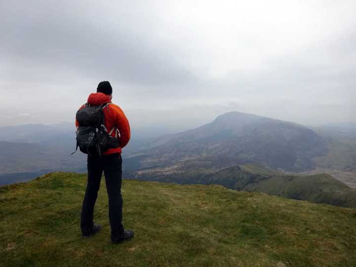
Cwm Pennant proved to be as quiet a spot as you can find in Snowdonia. A narrow surfaced road wound into its heart, and we parked up amid miles of verdant farmland speckled with pockets of woodland. The combe was broad and spacious, and the two ridges that would form our route sat discretely on two horizons.
Moel Hebog and its two outliers, Moel yr Ogof and Moel Lefn were closer and more prominent. The gap between first and second peak was sufficiently large that it’s debatable to describe the peaks as lying on a single ridge. We would have to drop down and go back up, then drop down and go back up again to gain the Nantlle Ridge. The latter also appeared to be formed of two parts. The first section between Y Garn and Mynydd Tal-y-Mignedd appeared more crinkled and complex, while the second section from Craig Cwm Silyn to Garnedd Goch appeared as a single table-like hill. It’s not often you get to see your whole walk spread out before you right at the start. But here we did and it was going to be a massive one.
The air was a little hazy but otherwise the sun was bright as we set off across bogland towards our first objective, Moel Hebog. There is no path from this side and the route is a bit of a slog up steep grassy hillsides.

Most of Moel Hebog is classed as access land, which means it is privately owned but open to the public. Frustratingly, this means that the owner has every right to put up walls and fences wherever he chooses to pen his sheep. On Moel Hebog, most were topped with barbed wire, like the walls of a prison. We had to cross several, all the way up to nearly 600m. On Plynlimon, the landowner had been kind enough to provide crossing points, but if these existed on Moel Hebog we didn’t find them. Only once was there a gate to pass through, and never a stile to cross over. Fortunately, we managed it all without ripping trousers or knocking over a wall.
We reached the summit at 10am after only 2 hours of walking. It would be a magnificent viewpoint in clearer conditions, but today the hazy skies made it feel like we were standing in a smoky room. To the north, blue sky sat above Snowdon’s multiple summits but we had to squint at them through the gloom. Meanwhile, in the other direction the southern coastline of the Lleyn Peninsula was close at hand, but the Irish Sea seemed distant. On a clearer day the sea should feel ever present on this walk, but today we barely felt its presence.
Nevertheless, Edita felt that this was the right moment to try out her Welsh accent.
‘It’s a cracking view up here,’ she said, trying to sound like BBC Springwatch presenter Iolo Williams, who is always talking about ‘cracking birds’.

A Welshman we met on Drygarn Fawr a couple of weekends ago also used the phrase ‘cracking view’, and now she thinks everyone in Wales uses the word ‘cracking’. It’s certainly one of those words that lends itself to a Welsh accent when spoken with a gently rolled R.
Despite the haze, I wasn’t going to complain about the view either, because the terrain in front of us was enough to feel the blood pulsing through my veins. Between ourselves and the Nantlle Ridge were two smaller hills, Moel yr Ogof and Moel Lefn. There were no trails marked on the map and I expected to be roughing it for the next section. In fact, there is quite a nice path over both peaks and it’s a pleasant ridge walk.
We stopped for the first of many snacks on Moel Hebog’s plateau-like summit, then raced down the slopes on its northern side. We had been alone until now, but now we started meeting other hikers on their way up from the tourist fleshpots of Rhyd Ddu and Beddgelert.
Somewhere on a ledge high on Moel yr Ogof is a cave that was a temporary home for the Welsh folk hero Owen Glendower when he was hiding from English hordes in the 15th century. It’s apparently not easy to find and we didn’t try. There is an interesting section of path only a few metres wide that squeezes between two vertical rock faces before emerging onto more open ground, followed by a short scramble up a boulder field. But otherwise it’s an easy grass ridge, open into Cwm Pennant on one side, and blocked by Snowdon on the other.

Once over Moel Hebog’s two outliers we had a long descent into the col dividing us from the Nantlle Ridge, our afternoon objective. The path was varied, passing through an area of abandoned 19th century mine workings, then on pleasant trails through a pine forest.
We rested at the lowest point of the walk after emerging from the forest at 300m on the flanks of Y Garn. It was about 12.30, and we had the first of our lunches before tackling the climb up to the 633m summit of Y Garn at the start of the Nantlle Ridge.
To avoid having to descend any further, we left the path and contoured around the steep east side of Y Garn to gain the main trail up. Once onto the trail it was easy if steep walking onto the summit.
One of the most daunting things about the Nantlle Ridge are the names of its peaks, which are impossible to pronounce without a bulldog clip attached to your tongue. Y Garn is one of the easy ones (the Y being pronounced ‘ee’, as in the Yorkshire phrase ‘ee bah gum’). Beyond it was the pointed prow of 695m Mynydd Drws-y-Coed (which could do with some vowels), then the rounded tops of 709m Trum y Ddysgl (I’m not making it up) and 666m Ffr-fyks-ake (now that one I might be). Out of sight behind that was 653m Mynydd Tal-y-Mignedd, before another long descent and climb back up to the final two peaks of 734m Craig Cwm Silyn and 700m Garnedd Goch. Luckily the peaks themselves are more memorable than their names.

Y Garn was a clear promontory, surrounded on three sides by fresh air. The only way onwards was along the ridge to Mynydd Drws-y-Coed, which both looked and sounded daunting, rising up on a tumbling ridge of rocky outcrops. Luckily it was easier than it looked. It was actually quite a nice scramble with plenty of hand and footholds, and not at all exposed.
Once over the summit we were back on a gentle grassy ridge that curved to the right and back up to the top of Trum Thingamyjig. Halfway along we passed two women, a mother and daughter, who had stopped for a snack. They asked us for advice about the route we’d just come up.
‘Is it really bad? I panicked coming down that bit back there,’ the daughter said, pointing along the ridge in the direction we were heading. I assumed she meant the scramble up to Craig Cwm Silyn, which Richard Sale described as the ‘tricky bit’ and Steve Ashton had purred over with delight (I exaggerate a little).
I reassured her about the handholds and lack of exposure. ‘I think the bit you’ve done is supposed to be harder,’ I said.

In fact, she was probably doing the route in the wrong direction. Most guidebooks describe the Nantlle Ridge from east to west. This is because it’s usually easier to scramble up than scramble down.
We continued onwards, over Trum Whatsit, where the view back to Y Garn and Drws-y-Coed is highly satisfying. Moel Hebog, our morning peak, rose in isolation; it seemed a long way off to the south.
Beyond Trum Oojamaflip was a long grassy ridge that looked neatly mown and rolled like a cricket pitch. At its far end we could see many people descending by a long elevated spur that descended to the forest we had passed through earlier in the day. It looked like a spectacular way to shorten the route. Had I been exhausted, I might have been tempted to return that way to Cwm Pennant. But it was still only 2.30. We had been awake for 11½ hours. I was still going strong with no craving for that sleep I was expecting to need.
Mynydd Tal-y-Mignedd makes up for being the most innocuous summit on the ridge by having the most ridiculous summit cairn, a giant 73m chimney-like obelisk (well, about 5m), that was erected for Queen Victoria’s diamond jubilee in 1897. You could call it the Matt Hancock of the Nantlle Ridge. We took photos and continued onwards.
Beyond was a drop of about 150m to a col before the final 200m ascent to Craig Cwm Silyn, the highest point on the Nantlle Ridge. We were approaching the section my guidebook writers had been fighting over. To climb or not to climb (or to C or not to C, as Shakespeare might have said had he written for Sesame Street)?
If you’ve been following this blog for a while, you’re probably aware that I’m not often one to grasp the bull by the horns if there’s an easy way around to its tail. Given that the ‘tricky bit’ occurred right at the end of an exhausting day, I was fully expecting to take the easy route. But perhaps I had retained a bit of mountain fitness from our expedition to Plynlimon, because as we approached the rocky ridge and saw the easy trail diverting to the right, I still felt in pretty good shape. Moreover the scramble didn’t look that bad.
In any case, if I’m going to call this post the Nantlle Ridge the hard way, I can hardly bottle the crux.
As things turned out, the tricky bit was very short, in the first 20m of the rock face. There were good handholds to begin with as we traversed to the right then back to the left. There was just one sketchy section when I scrambled up a steep rock gully using a couple of moves a rock climber might describe as ‘smeary’ (i.e. I relied on the friction of my hands and feet on the rock, rather than firm hand and footholds). It was only a couple of moves and then I gained the safety of a ledge. Edita found a steeper but probably safer way up a narrow crack to the right of the gully which came out on the same ledge. After that it was nothing more than a steep walk up to the summit.

The weather had been worsening all afternoon after the morning brightness. The sky had gradually darkened as we traversed the Nantlle Ridge. We huddled inside the dry stone wall that formed the summit shelter on Craig Cwm Silyn and had our second lunch, expecting the heavens to open any minute.
But the rain never came. We walked along a long plateau to the final summit, Garnedd Goch, then dropped down into Cwm Pennant. We followed a dry stone wall across boggy moorland for about 3km. The final section had a sting in its tail as the footpath marked on the Ordnance Survey map disappeared into a proper wet bog — one of those where what looks to be a path invariably turns out to be a water channel lurking in a grass tussock. I lost count of the number of times my mouth spewed the word ‘bollocks’ as my leg disappeared into the drink.
I had been doing OK up to that point, but the final few kilometres dragged on and I was walking like a zombie as we approached our car along a narrow tarmac road. It was 6.30; we had been walking for 10½ hours and I had been awake for five more.
But I was happy and satisfied. I would do it again.
You can see more photographs from the walk in my Flickr album


Hi Mark, thanks for the story. Getting up at 3am to go and hike some grassy knolls? No wonder Edita nodded off! Thanks to your graphic images I can’t find much visually stimulating in the landscape. Perhaps the locals were so gob smacked by their surroundings that they could only mutter curses at promontory features. I’ve no idea what Welsh sounds like, given the spelling it looks designed to be arcane. (I’m trying not to be offensive).
Best wishes from Tasmania where there is no shortage of vowels.