
Peru’s Cordillera Blanca mountain range offers a veritable playground for the mountain lover, be they a trekker, alpinist or high altitude snow plodder (which, if you’ve followed this blog for a while, you will know is a niche category I like to consider myself a master of). In the compact area of just 180 km north to south and 20 km east to west lie 25 peaks over 6000m and countless others over 5000m. Nearly all of them are within a day’s drive and a few hours of trekking from the comfortable town of Huaraz, with its profusion of accommodation, shops and bars. Rolling grasslands and primeval quenual forests creep up enclosed glacial valleys in amongst towering snow-capped peaks, providing glorious scenery for trekking. Meanwhile the peaks themselves provide a range of climbing from big rock walls to steep ice climbs, non-technical if strenuous snow plods to horrendously difficult fluted faces and corniced ridges. Better still there is minimal bureaucracy to contend with: a month’s climbing permit costs around $25 USD and provides access to as many peaks as you like.

This last point turned out to be a great blessing. Last month I reported that I was intending to climb 6768m Huascaran, Peru’s highest mountain, not especially steep and a good example of one of the snow plods I’ve been referring to. The first hint I got this plan may change was upon checking my email shortly before leaving the UK to head out to Peru, and finding one from my expedition leader for the climb, Phil Crampton of the expedition operator Altitude Junkies. The email had a single word subject line Tool, which before you say anything is not his nickname for me. He was writing to suggest I pack a second ice tool on the chance we end up climbing some more technical peaks instead. While leading an expedition on Huascaran earlier in the season Phil had bumped into a group of Czech climbers including Radek JaroÅ¡, who last week became the 33rd person to climb all fourteen 8000m peaks by summiting K2. The Czechs were climbing Huascaran Sur (the higher of its two summits) as part of their K2 acclimatisation programme, and told Phil they had been unable to climb it because of several uncrossable crevasses guarding the route. He discovered not only was this true but unusual snow conditions meant Huascaran Norte posed an avalanche risk as well.
By the time we arrived in Huaraz there had only been two ascents of Huascaran all season, and those were back in May. Team after team arrived back after spending days on the mountain with very little opportunity to climb. Huascaran’s two gigantic domes dominate the view north down the valley from Huaraz, rising high above every surrounding peak. It’s a mountain I would love to climb someday, but it was looking like this year wasn’t the year.
I laughed when Phil provided his alternative suggestion to Huascaran. A few months ago I sat with him at the Courtyard Hotel in Kathmandu while he showed me photos of a number of Peruvian peaks to try and encourage me to join him. He knows I’m not the most gifted technical climber, so his aim was to show me how straightforward they were.

“That one looks fine, that one looks fine, that one looks OK too,” I said as he scrolled through them. “That one looks absolutely horrendous. Not a hope in hell of me climbing that one.”
The latter peak was 6162m Ranrapalca, a precipitously steep snow face with an overhanging rock section onto its summit plateau.
Fast forward to July in Huaraz. “A Brazilian climber showed me a photo of Ranrapalca’s Northeast Ridge,” said Phil. “There’s been lots of snow and it looks in great condition, much better than last year. There will never be a better time to climb it.”
Unhappily all my team mates on the expedition appeared to be technical alpine peak baggers who had booked a trip to Huascaran with the aim of getting some experience at high altitude. Phil’s plan of exploring the nearby Ishinca Valley with an opportunity of climbing a number of more technical peaks instead of just one big snow dome appealed to them, especially as Ranrapalca spurred them on by standing proudly above the rooftops of Huaraz in an impressive wall of ice.
A one hour drive took us to the trailhead at Pashpa, a lovely green meadow high above the Rio Santa Valley which defines the western boundary of the Cordillera Blanca and contains Huaraz and various other population centres. The trailhead provided the most amazing natural viewing platform for Huascaran, whose enormous dome-shaped bulk dominated the landscape like no other surrounding peak. We were pretty much all in agreement that despite the change in plan Peru’s highest mountain remained unfinished business.

From Pashpa we had a three hour trek up the short Ishinca Valley to its head. It was a pleasant walk across broad grasslands initially to reach the entrance to the valley, then up a narrow canyon hemmed in by gentle rock walls on either side. The lower part of the valley passed through primeval forest of low-hanging quenual, thought to be the highest growing tree in the world. We were at an altitude of 4000m, and in the Himalayas this would find us in a climate zone where nothing more sizeable than dwarf varieties of juniper and rhododendron could grow. The upper part of the valley was open grassland with rocky outcrops.
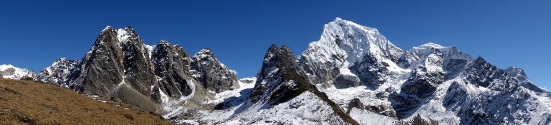
Ishinca base camp was in a lovely setting underneath the glaciers and mounds of moraine at the very top of the valley. Two peaks dominated the eastern end of the valley. 6034m Tocllaraju, a steep pyramid of fluted ice and tumbling seracs, was the more obvious of the two peaks, while 6274m Palcaraju stretched further back. Its summit wasn’t visible, and from camp it resembled more of an extended plateau protected by a series of ice ledges. Both valley walls consisted of grassy hillsides studded with boulders. To the north a little snow triangle, 5480m Urus Este, peeped up above the hillside, while to the south a side valley led off from camp to 5530m Ishinca and 6162m Ranrapalca, both of which were hidden from view. The green meadow we found ourselves camping in was extensive with space for hundreds of tents, but with only a handful of other teams camped around the fringes it felt extremely spacious. A large and comfortable refugio (mountain hut) has been constructed in one corner, providing accommodation and meals for those not wishing to camp, and we dropped in for beers once or twice during our stay at base camp, and to restock our wine cabinet.
A network of glacial streams flowed across the meadow, providing an ample supply of water, but a wandering herd of cows shared the meadow with us, which meant the water couldn’t be trusted for drinking. The behaviour of these cows became gradually more sinister as the days passed and our kitchen crew began feeding them. On several occasions I wandered away from camp for a pee only to discover one of them had sneaked up on me as I was going about my business. On one memorable occasion two of the cows started fighting in the middle of our camp. The loser fled through the two feet of space which divided my tent from Tanya’s, stumbling and nearly falling into mine as it passed. Luckily I wasn’t in the tent at the time, but of all the ways to end an expedition being crushed by a falling cow isn’t one I want to experience. After a few days of this several of us began to sense we had stumbled into a Far Side cartoon, and I couldn’t help wondering if while we were inside our tents the cows stood up on their hind legs and talked to one another.

With five peaks accessible from base camp Phil’s plan was to acclimatise on Ishinca by doing a long traverse of the peak in a single push from base camp. Tocllaraju and Ranrapalca were to be our two main objectives, and both would require high camps on their lower glaciers. These plans would change several times through the ten days we spent at base camp, mainly in response to suggestions from Phil’s sidekick Pasang Ongchu Sherpa, a UIAGM-qualified guide from Nepal who worked quietly behind the scenes as a kind of Sundance Kid to Phil’s Butch Cassidy. Pasang is Phil’s climbing sirdar on 8000m peaks; I have climbed with him on three previous expeditions, and owe him several beers for helping me safely back to Camp 2 during my summit day on Manaslu in 2011.
We were keen to start tackling the peaks, but every traveller to the Cordillera Blanca needs to remember they have come to a very high altitude very quickly and be patient while they acclimatise. It had taken us only a day’s drive to get from Lima by the Pacific coast to Huaraz at 3090m. We spent three nights there before driving to Pashpa at 3600m and walking to Ishinca base camp at 4400m. It would have been foolish to tackle a 5500m peak right away, and would almost certainly have resulted in an immediate return to Huaraz to recover from altitude sickness.
We spent the first two days resting, and on the second I took a short acclimatisation walk up the side valley south of camp with Mike, Marc and Tanya for our first view of Ranrapalca. It took about an hour to reach a beautiful secluded combe 200m above camp, where a sparkling waterfall fed a peaceful green camping spot, and the sheer north face of Ranrapalca rose above, an intimidating wall of rock and ice crowned with a snowy cornice. It was the route Phil and Pasang had taken up last year, and the one I had dismissed as pointless for someone of my talent as we looked through Phil’s photos in Kathmandu. But the left hand skyline marked the northeast ridge which Phil intended for us to take this time. It rose at an angle of about 40° and looked like it might be practical, but the upper section was steep, more like 50 or 60°, and quite sustained. It was a tough ask, but I thought I might give it a go.

On the third day we decided to climb Urus Este rather than Ishinca, at Pasang’s suggestion. Although both peaks were a similar height Urus Este was closer to camp and would be a shorter day. We were encouraged to see other teams climbing it while we acclimatised and coming back successful. We left at 4am during darkness, and climbed surprisingly quickly up a steep scree ridge. I decided to potter along at the back believing that at least one of the other climbers would turn out to be a slow acclimatiser and fall back as we gained height. It was a good guess, and the slow acclimatiser proved to be fellow Londoner Marc, who on the journey up from Lima sat beside me in the bus and regaled me with his terrifying stories of travelling across Africa. These included getting robbed in Uganda after turning over his Land Rover on a dirt road, and narrowly avoiding a rogering in the gents toilets of a gay bar in Madagascar by fleeing through sewage. By comparison this trip was going to prove a breeze, but at that moment in time Marc was struggling. I knew we were in no hurry, so I slowed to his pace and we ambled up to the start of the snowline among a tongue of loose boulders at around 5000m. It was just after 6am when we arrived and the sun was beginning to rise, but there was a distinct chill in the air and my fingers got very cold putting on my harness and crampons.
I roped up with Marc and Pasang from there on, and the remainder of the ascent was straightforward, but very picturesque and pleasant. The route traversed a snow slope and crossed a short horizontal rock band before a long trudge of a snow slope led to a wide saddle dividing Urus Este’s summit cone from a tower of rock which worried me as we arrived beneath it. I was concerned it might be the higher of the two summits, in which case I would need a good head for heights and a pair of rock shoes (and preferably a little more climbing ability). Thankfully its appearance was deceptive, and as we made our way up the summit cone, which involved a couple of steep snow slopes and a short band of rock which required some mixed climbing skills, it became obvious the rock tower was much lower.

Our party of ten reached the summit in three rope teams between 8am and 8.30, and the first team waited so we could all be on the summit together. Its stepped ridge of snow was just about big enough to accommodate all of us, though we had to be wary of an overhanging cornice on its western side. As well as Marc, Pasang and me the summiteers were Phil on the first rope with Canadian Ryan and the Yorkshire couple Mike and Anna, and our Ukrainian climber Tanya on the third rope with the two Peruvians Alex and Eli.
Although at 5480m Urus Este is a relatively minor summit in comparison to other peaks in the Cordillera Blanca it’s still a fantastic viewpoint, especially of the other four principal peaks of the Ishinca Valley. The route we would be taking up Tocllaraju was now much clearer, across a snow plateau and over steep seracs to reach the summit ridgeline. Palcaraju’s main summit could now be seen a long way behind the plateau which appeared to be its highest point from camp. The rock faces of Ranrapalca rose proudly across the other side of the valley, and the triangular snow peak of Ishinca looked very small beside it, little more than a minor bump on the horizon. From this elevated seat we could see a treasure chest of turquoise lakes nestling in high combes, only visible to those who climb as high as we had.

The view to the north was no less enchanting, though the peaks were more distant. 6188m Copa reminded me of a miniature version of the view of Dhaulagiri from Poon Hill in the Himalayas, a little like a child’s drawing of a house with sloping roofs. As well as being smaller Copa’s walls are gentler, and I concluded it was a peak I would fancy my chances on another time. In a direct line behind it was Huascaran, and Huascaran Sur was completely hidden from view, with just the domed flank of Huascaran Norte peeping up over Copa’s shoulder. We lingered for many photos and the odd summit video before heading down again. The descent was straightforward but knee jarring, and the loose pebbles of the scree ridge we ascended in the dark were hazardous, though a fall meant little more than a sore backside and a bruised ego if anyone happened to be following behind. It was tiring, and I felt like I’d had a good workout as I hobbled into camp at 11am after seven hours up and down.
The following day was a rest day, which we spent playing rock boules. It was allegedly my responsibility to bring a proper boules set over from the UK, and Phil expressed derision when I turned up without one explaining the extra 6kg exceeded my baggage allowance and I didn’t consider a bag of metal balls essential mountaineering equipment. I pacified him a little by providing gaffer tape to label the fist sized rocks he selected to use as an alternative. Rock boules isn’t as easy as proper boules, and involves about as much skill as an average edition of The X Factor. The boules have a tendency to fly off at random angles upon landing, which proved to be a problem the first game we had when we played a little too close to the tents. With falling cows and flying rocks it was a rather more perilous place to camp than we expected.

Also during our rest day Ryan explained that by coming to Peru he was missing the highlight of the calendar in his hometown of Calgary, Alberta, the Calgary Stampede, a celebration of cattle ranching during which it’s perfectly normal to turn up to business meetings dressed as a cowboy. Events include horse breaking, bull riding and cow wrestling (running after a cow and wrestling it to the ground with your bare hands). We provided Ryan with several drinks in an effort to induce him to demonstrate this last event on one of the Far Side cows grazing in our meadow, but I’m sorry to say he never obliged. On a similar note Anna told us about the Yorkshire pastime of cow tipping (pushing over a cow while it’s sleeping standing up). I’m familiar with cow tipping from my own upbringing in Yorkshire. I’ve heard lots of people talk about it, but I’ve never seen anyone actually tip one over. I believe it’s about as real as sheep tossing, and Anna wasn’t able to relieve me of my scepticism either.
Our plans changed a few times during this rest day period. We were intending to climb Tocllaraju next, but upon learning a large German group with 11 clients camped nearby were planning on climbing it the same day we decided it might be too much of what Phil eloquently described as a clusterfuck. Our next plan was to try the Northeast Ridge of Ranrapalca, but Phil’s bullish insistence the mountain was in ideal condition was wavering, I believe due to some gentle administering of a reality drug by Pasang as they discussed it in their tent. I had the impression we hadn’t fired them with enthusiasm when we demonstrated our climbing skills on Urus Este, and they suggested we might prefer to try Ishinca instead. Personally I was delighted our plans had gone full circle since Phil showed me photos on his laptop at our hotel in Kathmandu, when I mentioned Ishinca looked like a nice peak while Ranrapalca was a better option for crows.

So the morning after our rest day we made an early start, leaving base camp shortly after 1am by the light of our headlamps. We had a much longer walk to the snow line than we had on Urus Este. The side valley to reach the foot of both Ishinca and Ranrapalca, consists of a series of combes rising ever higher and divided by waterfalls. I had already seen the first of these during my acclimatisation hike a few days earlier, a grassy meadow an hour’s climb out of camp, and it provided as picturesque a mountain scene as you could wish for. We passed through it during darkness this time, and a similar combe a short distance above it. Although we couldn’t enjoy the view the flatter terrain provided some respite as we crossed through them. The third combe was much larger and contained a brilliant turquoise lake, Laguna Ishinca. We passed along the left shore of the lake, but had little sight of it in the darkness. We were now above the vegetation zone and as the trail began rising more steeply through scree slopes and boulder fields our party of nine became increasingly strung out.
We reached the snow line at around 4950m at 3.30am, having completed nearly half the ascent. The remainder was much more interesting than I expected, and far from being the boring old snow plod my guide book led me to believe. After putting on harnesses and crampons, and roping up in slightly milder if windier conditions than we experienced on Urus Este, we ascended a short 30° snow slope underneath a subsidiary peak before turning to the right to cross some pressure ridges and make a steep traverse up a long featureless snow slope to reach the ridge between the subsidiary peak and Ishinca’s main summit. Above us the summit dome was protected by a sheer cliff of rock, and between us the slopes rose in a series of ice shelves. To reach the top of the first one Phil had sent Mike into the lead on the first rope, and I could see he was making his way up using both ice tools. We retrieved our second one from our packs and followed behind. At the top of this first steeper section the trail turned to the left to pass underneath the second ice shelf before turning sharply and steeply to the right to gain its top via a snow ramp. The ramp was riddled with narrow crevasses, and I had to take care looking out for cracks in the ice using the dim beam of my headlamp. Ahead of me on the rope Pasang and Marc had disappeared around a corner, and I had to shout to them to slow up as I negotiated my way through. I was relieved to reach the top and see them ahead of me.

A long, gentle snow slope rose gradually to the final difficulty of the summit dome, and as we climbed it the orange glow of sunrise backlit the horizon to the east. The summit dome was guarded by a steep cliff face, and a steep snow slope on its right hand side led the way onto the top. It looked daunting from below, and Mike paused at its base.
“Get a fucking move on, Mike,” shouted Anna behind him by way of encouragement.
Yorkshiremen have an unjust reputation for wife-beating, but there was no doubt who wore the trousers in Mike and Anna’s household. Eventually Phil took over the lead and the rest of us followed along behind.
The 60° slope was made a good deal easier by the footsteps of previous climbers. One by one we made our way onto the summit, a banana-shaped ridge, guarded by a cornice on its right hand side in the form of a six foot snow wall. Counter-intuitively this cornice was also our route down the other side. There was only a person-sized drop behind it onto the ridge between Ishinca and Ranrapalca, and somebody had cut a slice out of the cornice as a gateway down to it. There was only room for about three people on the very top, and by the time I reached it the first rope team of Phil, Mike and Anna were already making their way through the gap. It was shortly after 6am and light at last, but it was very windy and the summit was not a place to linger. Marc, Pasang and I took a few quick photos before following the others through the cornice.
The descent was an experience to savour as we descended a gentle snow slope to a col. On the other side of the col Ranrapalca’s northeast ridge rose before us, and we could now see that whatever condition it may have been in earlier in the season it had now reverted to its more usual state. Although it was a snow climb for the majority of its length a steep rock band guarded the way onto its summit plateau. It was obvious to all of us the rock band would have presented a considerable challenge — steep, exposed and difficult — and the decision to climb Ishinca instead was the right one for a party of our abilities.

Although Ishinca was a much smaller peak it had been a thoroughly enjoyable climb. In another location and surrounded by lower peaks it would have felt much more significant. The descent back to base camp in the main Ishinca valley dragged on a bit, but the views across the valley to Urus Este, Copa and Tocllaraju were truly marvellous, and for much of the way Ishinca itself rose grandly above its very own shimmering turquoise lake. When I reached the vegetation zone again and descended through verdant pastures I could only marvel at what a truly special place the Cordillera Blanca is. When I limped into base camp shortly after 9am I knew I had completed as grand a day hike as any I have done in any part of the world.
We had another rest day the following day, which Marc and Mike decided to occupy by climbing Urus Este for a second time in search of 3G connectivity in order to send messages to friends and family. They had to climb all the way up to 4800m before they heard Marc’s phone go ping inside his pocket. Not everyone was missing the lack of contact with the outside world. Tanya had a 16 year old son back home in California, but the first I suspected that she might not be missing him as much as you would expect was when she told us he was thinking of joining the armed forces. In response to this suggestion of his, she had packed the poor fellow off to a six week army boot camp a few days before coming to Peru, to “help him make his mind up about his career choice”.
I needed to take it easy for the next day and a half as we rested at base camp. As I clomped down the steep scree pathways and secluded combes below Ishinca in my heavy mountaineering boots, I realised I had inflamed an old sporting injury. I ruptured an achilles tendon playing football 20 years ago, and every now and again I suffer from achilles tendonitis in my right ankle. It’s an injury that appears and disappears at random, and apparently without logic. I spent most of the following day swallowing ibuprofen and performing stretching exercises to an audience of curious cows. None of these things would cure my injury, but I hoped they would be enough for me to attempt Tocllaraju without too much pain.

The wind had picked up, making it a little colder, and Phil and Pasang hatched another change of plan. We intended to put in a high camp at 5000m on the snow plateau at the foot of Tocllaraju’s pyramid, but it was now going to be exceedingly windy up there, and they convinced us we might prefer to launch our summit attempt from base camp in a single 1600m push. I racked my brain for the last time I had completed so much vertical ascent in a summit day and realised the answer was never, but I was willing to give it a try.
To ease the burden on my belligerent right ankle I decided to carry my heavy mountaineering boots up to the snow line and complete the first section wearing my approach shoes instead. I wasn’t the only person who was having foot trouble. Mike had bought a new pair of North Face boots for the expedition, but they were starting to fall apart on their very first outing and he was keeping them together with gaffer tape. While many people might be upset by this, the Yorkshireman Mike was managing to find positives.
“Ay up, I reckon I might get a free pair of boots out of this,” I overheard him saying to Anna outside my tent. “That’d be a right bonus.”

We made a good fist of our 1600m attempt on Tocllaraju. Leaving at 11pm in the evening we climbed through the night up dusty scree slopes and over boulder fields to reach the snowline at 2am. The next part of the ascent crossed a gentle snow plateau that steepened imperceptibly until it reached a 30m wall of ice. This was the steepest, most technical obstacle of our trip, and we overcame it using both ice tools and the front points of our crampons. It was 4am when we reached the top, and here our attempt came to an abrupt and unusual end when we arrived beneath a huge crevasse spanned by a rickety old ladder that creaked underneath him as Pasang edged his way across. We had reached an altitude of 5400m, but the rest of us dared not follow. I spoke about this ladder in a little more detail in a previous post. I don’t know where it came from or who put it there, but it would not have surprised me to learn there was a haunted house somewhere down the valley which now had one missing.
And so we came down again and headed back to the fleshpots of Huaraz. Well, the beerpots, anyway. In terms of mountaineering objectives it had not been the most successful of expeditions, but that happens sometimes, and the flexibility of our leaders Phil and Pasang had enabled us to come away with something worthwhile. As our plans evolved to react to circumstances we set our sights on three 6000m peaks: Huascaran, Ranrapalca and Tocllaraju. We hadn’t got up any of them, and harsher critics would say the two peaks we climbed, Urus Este and Ishinca, were little more than modest day hikes. It depends how you rate your mountain adventures though. If points are awarded for summits only then we didn’t score highly, but if your aim is simply to enjoy the whole experience of being in the mountains our expedition was a roaring success: great company, beautiful scenery and an opportunity to obtain peace and tranquillity in this busy life of ours.
One thing I discovered is that, like the Himalayas, the Cordillera Blanca is a mountain range many people return to again and again. It was my first time there, but I don’t think it will be the last. For one thing there’s still Huascaran.
I’ll end with a wee video of our Ishinca summit day and encourage you to see the rest of my photos and videos from the trip.
This post is dedicated to Leo Rasnik, my modest and unassuming guide on Aconcagua in 2010, who lost his life in an avalanche on the west face of Tocllaraju in 2013.


Loved the write-up Mr Horrell, sounds like a beautiful area with interesting cows!
Thank you, Mr Axe. Yes indeed, a few more sheep as well and it would be a New Zealand climbers’ paradise. Will you be passing through Wales on your next Peak to Peak Challenge?
Its very tempting now you mention it Mr Horrell, you can never can resist a little dig can you!
Hi Mark,
Been a long time reader for years. I just got back from Peru last week and checked your blog, only to find that you have been to the Cordillera Blanca at exactly the same time. What a coincidence!
I was there from July 12th to August 3rd with German operator Amical. We had to make changes to our plans, just as everybody else. The original plan was to climb Alpamayo, Quitaraju and Huascaran – we ended up doing Alpamayo (French Direct), Chopicalqui (instead of Huascaran), and the relatively easy Pisco at the end because there were still two days available. Weather on our summit days for Alpamayo and Chopicalqui wasn’t good (whiteout and snowfall), but we were lucky enough, as on the following days the weather was good, but nobody reached the summits due to too much snow!
Anyway I had a great time. Would have been fun to meet you there…
Cheers,
Peter
Hi Peter
Thanks for dropping by and leaving a message. It sounds like you had a successful and enjoyable trip despite the conditions on Huascaran. It pays to be flexible – congratulations! July was a good month for you. You won the World Cup as well (we watched the Germany vs Brazil game in Huaraz).
Regards,
Mark