
We arrived at the Old Inn in Carbost, the remote Scottish pub where we would be staying that week, at five o’clock on Sunday after a two-day drive from London. The car park was full, but it wasn’t obvious which building beside the shore of the loch was the pub. We found an innocuous door down a dark staircase where a sign pointed “Way Inn”.
Everything changed when we opened the door. The pub was heaving, and we could barely get to the bar and claim our room for the night. A Scottish folk band called Nae Plans were playing, and they seemed to be popular. I googled them and discovered they were a “daredevil folk duo” whose name springs from their tendency to turn up and improvise.

Our own plans were also fairly loose. We were here for five days, and hoped to climb as many of the 11 Munros on the main Cuillin ridge as we could in a series of day hikes, including the infamous Inaccessible Pinnacle, the only Munro that’s a technical rock climb. But the weather forecast was dreadful, and I knew from experience that would make a big difference on these peaks.
When I came to the Cuillins thirteen years ago with my friend Tony, we had the same plan, but we only managed to get up four of the Munros. The peaks involve a lot of exposed scrambling, and in poor weather the rocks were slippery and hazardous. Navigation was also a problem, and there was a high risk of finding ourselves in a dangerous situation.
This time we hired a guide, Andy Hogarth, through West Coast Mountain Guides, an agency based in Fort William. I knew that by having a guide with a rope who knew the routes, we had a much better chance of getting up to the summits in foul conditions. But would it be enough?
Our plans were fairly loose, but thankfully Andy’s were well formed. He had spoken to Edita during our drive up. He said that although a lot of cloud and rain was forecast, the biggest problem was going to be the wind, which was forecast to reach speeds of up to 60mph later in the week. Monday was looking slightly better, though, which meant that perhaps we should try the Inaccessible Pinnacle (or In Pinn, as its better known) on our first day.
We met him at the youth hostel at Glen Brittle, on the west side of the Cuillins, early on Monday morning. The sky was clear below, but it was cloudy on top of the peaks. We hoped it might clear later on, but the winds off the Atlantic mean you can never be sure what’s going to happen on Skye. Weather forecasts tend to be much less reliable than elsewhere in the UK.

Andy was an experienced guide and instructor who had spent 12 years with the British Army before becoming a guide. But if I expected a sergeant-major type barking orders and screaming at me for being a big girl’s blouse, I couldn’t have been more wrong. Andy was cheerful, quietly spoken and accommodating. He was also a good deal younger than we were, which perhaps helped.
He spread out his Harvey’s map on the bonnet of his car (the best available map of the Black Cuillin) and explained his plan for the day. We would head into Coire Lagan and climb Sgurr Mhic Choinnich, an interesting initial scramble which would enable him to see how competent we were. After that, we would head north-west along the ridge, passing over the top of Sgurr Dearg, where we would see if the weather was good enough for a tilt at the In Pinn. From there we would climb a third Munro, Sgurr na Banachdich, before descending back to the youth hostel.
The weather looked OK when we set off at 9am, with patches of blue sky. We ascended grassy moorland slopes on a good trail, with the sea lapping against the shoreline below, and the islands of Rhum and Canna a short distance away.
By the time we reached the corrie, Coire Lagan with its tiny turquoise lake nestling among grey rock, the bad weather had started to settle in for the day. The corrie was hemmed in by scree slopes on three sides, and the tops of the peaks were touched by cloud.
Andy pointed out Sgurr Mhic Choinnich on the ridge above us. It didn’t look like much of a summit — more of a clifftop overlooking a gap in the ridge. On the other side of the gap, the crumpled black flanks of Sgurr Thearlaich rose higher into the clouds, but Sgurr Mhic Coinnich was the one that’s classified as a Munro, so that was our first target.

We kept to the left-hand edge of the steep scree slope at the back of the corrie, where the going was a little easier. Beneath Sgurr Thearlaich we could see an enormous bank of loose rock in the form of a giant scree slope. This was the Great Stone Chute, supposedly the easiest way up Sgurr Alasdair, the highest mountain on Skye. We hoped to climb this peak later in the week. It looked like a heartbreaking route up, and I hoped that Andy would find us an alternative.
By keeping to the edge, we reached the top of the scree slope without difficulty, where we left our bags in a small alcove, and roped together for the scramble along the ridge to the summit of Sgurr Mhic Choinnich.
The ridge was broad and flat to begin with, and we looked through a thin veil of mist to the jagged outline of Bruach na Frithe, Am Basteir and Sgurr nan Gillean, the three northern Munros of the Cuillin ridge.
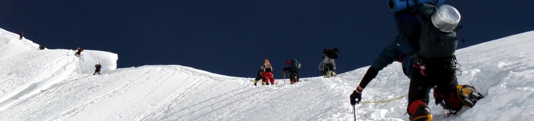
The terrain steepened and the scrambling began. It was of a type and exposure that might have made me nervous had we been ascending on our own, but with the security of a guide and a rope, it presented no problem. We were soon standing atop our first tiny summit of the week, Sgurr Mhic Choinnich (948m), my 95th Munro. We were well and truly in the clouds, and could see almost nothing.
A squally shower overtook us on the way down, and we were soon soaked to the bone. We passed another guide and client on their way up, and we discussed the weather.
‘I think you’re going to be out of luck with the In Pinn today,’ said the guide.

This may have been a ploy to keep us off it. We later learned that both guide and client climbed the In Pinn that day, but our decision to skip it proved to be the right one for us.
We retrieved our bags and headed up steep and slippery slabs which skirted the left-hand side of An Stac, another more substantial pinnacle on the ridge immediately beneath the In Pinn. Andy pointed out the In Pinn as we skirted beneath it. In the cold, grey, damp conditions, it looked unwelcoming. My hands were cold, and I knew I would need to take my gloves off to tackle the rock.
It took us only a few seconds to make a unanimous decision. We would leave the In Pinn for the end of the week, when the forecast was better.
We scrambled up to the summit of Sgurr Dearg, which would be a Munro but for the dark finger of rock piercing the gloom behind us. The In Pinn was only a few metres higher, but that made all the difference. We would have to climb it at some point.
Visibility was now just a few metres and we could see nothing of the land around us. In normal situations I would have needed to fish out my map, compass or GPS and try to figure out the route beyond. Instead, all we needed to do was follow Andy as he zoomed down the rocky slope on the other side of Sgurr Dearg.

I can only guess how far we descended, perhaps a couple of hundred metres or more, but soon we were climbing back up and keeping to the left side of the ridge. A short while later Andy took us up to an innocuous pile of stones on the crest of the ridge.
‘Congratulations, this is the summit of Sgurr na Banachdich,’ he said.
It was certainly the high point of the ridge as far into the mist as we could see, but short of getting my GPS out, I would have to take his word that this was indeed Sgurr na Banachdich (965m), my 96th Munro.
Our descent was swift. We shot down scree slopes, then grassy hillsides, where we rejoined the trail back to the youth hostel in Glen Brittle.
The next two days provided some of the worst weather Skye has to offer, but Andy still had some plans and we were nothing if not determined.
The forecast for Tuesday was appalling, with 60 to 70mph winds forecast on the summits. This extreme weather was not forecast to arrive until 11.30, though, so Andy believed we might have time to sneak up Sgurr nan Gillean if we started early.
Sgurr nan Gillean has a reputation for being the second-most technical peak on the main Cuillin ridge after the In Pinn. It’s the most northerly of the Munros and ends in a dramatic sequence of pinnacles known as the Pinnacle Ridge. I had climbed its easier neighbours Am Basteir and Bruach ne Frithe on my previous visit. There was an outside chance we might be able to climb all three if we were really quick, though Sgurr nan Gillean was our main priority, as I hadn’t climbed it before.

It was still dark when we met at Sligachan at 6.15, on the road past the northern side of the Cuillins. We started with a long walk across bogland, thankfully on a relatively good trail. Andy set off briskly and I sweated to keep up. Up ahead, the three peaks rose in silhouette.
After an hour of rushing along behind, we reached a deep gorge to the left of the trail. By now we could clearly see the five black outlines of the Pinnacle Ridge ahead of us. Sgurr nan Gillean, which appeared as a dark triangle as we approached, was in reality a line of five rocky peaks squashed together and increasing in height from left to right. The highest appeared to rise more gently, but this was deceptive.
We traversed up wet slabs to the right of the gorge until we reached a combe beneath the black rock walls of Am Basteir. The early start had left me short of a breakfast. I could feel myself running out of energy, and I had to call a halt to wolf down a sandwich.
It was still only 8.30, but already the weather was starting to worsen. We could see clouds racing behind the summit of Sgurr nan Gillean. We zigzagged up a scree slope beneath Am Basteir. Towards the top we were still sheltered from the wind, but we could see from the speed of the clouds that it was going to hit us hard when we emerged onto the col between Sgurr nan Gillean and Am Basteir.
We left our packs, put on our helmets and harnesses, and sneaked to the foot of a short 20m rock climb known as Nicholson’s Chimney.
‘At the top there’s a short scramble,’ said Andy, ‘but then that’s it — we’ll be on the ridge with no more shelter from the wind. We’ll know whether it’s possible to reach the summit.’

Rain was now falling and the outlook didn’t look promising. Clouds were billowing from the south-west. The signs were that the storm was about to arrive early, but we’d be sheltered in Nicholson’s Chimney and we decided to give it a try.
The climb looked easy as Andy raced up it, with plenty of outcrops and sizeable ledges, but Edita soon become stuck about a third of the way up. I climbed past her, but got stuck myself in more or less the same place. My gloved hands slid off wet rock and I could find no decent handholds.
I took my gloves off. This helped a little, with more friction on the rock, but still I wasn’t happy.
‘If I can’t get up this thing, then how the hell am I going to manage the In Pinn?’ I thought to myself.
It was an embarrassing start to our rock climbing. But Andy had me held on a belay, so I was in no danger if I fell, apart from a few bumps and bruises. I was just going to have to give it a try. I found two tiny handholds and, trusting to friction, managed to drag myself up onto the next ledge.
I scrambled up a couple of metres to give Edita room to come up behind me. I intended to talk her through the move, but I had no idea what I’d done to get myself up. It took her a few minutes, but eventually she was able to follow me up.
When we joined Andy at the top of the chimney, he told us the climb was graded a ‘Diff’, which meant that although it wasn’t as exposed, it was actually harder than the In Pinn.

The bad news was that the weather was getting considerably worse. Above the parapet it was clear that we would not be able to continue to the summit.
We lowered ourselves back down the chimney and retreated back to Sligachan in a gathering storm. Rain lashed horizontally into our faces. The rain cover kept flying off my rucksack and sailing across the bog. There were times when I thought I was going to get blown off my feet.
We were dripping like salmon by the time we reached Sligachan. Edita and I decided to dry ourselves off with a pub lunch. The staff of Seumas’ Bar, the substantial public bar behind the Sligachan Hotel, are obviously used to welcoming hikers in our state. There was a big drying rack in the porch. We peeled off our outer layers, hung them up and retreated into the comfort of the bar.
The weather remained horrible all afternoon. We sheltered in our car and drove around the island on a sightseeing trip with a difference — we could barely see anything at all as we drove through wet mist, comfortable in our metal box as the wind lashed rain against the windows.
The weather forecast was only marginally better for Wednesday. The rain was set to continue, but the winds would only reach a paltry 30mph. We had nothing better to do, so we decided to have a go at the two central Munros, Sgurr a’ Mhadaidh and Sgurr a Ghreadaidh, which Andy said were safer and more straightforward.
There isn’t much to say about the day’s hike, except that we achieved our objective. It was a box-ticking sort of a day. The weather was piss-awful, and we could barely see a few metres ahead of us. I was grateful that Andy knew the route, and all we had to do was follow along behind him as we climbed grassy slopes then scree, eventually reaching a notch in the ridge between the two peaks.

We left our bags beneath an overhanging rock and headed to the left up Sgurr a’ Mhadaidh (918m), the lower of the two Munros. It was an easy scramble, almost a staircase. We were soon on the summit, where I ticked off Munro no. 97.
On the way back down we passed some flat areas of rock that had been cleared into bivouac pitches. The full traverse of the Cuillin ridge from south to north is regarded as one of the UK’s top mountaineering objectives. It takes most ordinary people two days, and it’s here beneath Sgurr a’ Mhadaidh that many people stop for the night. Edita made me lie down in one of them for some stupid photos.
Back at the notch, marked on the map as An Dorus, we roped up for the trickier second peak, Sgurr a’ Ghreadaidh (973m). There was a short initial 5m rock climb, then some tricky sections up smooth slabs. There were no views through the mist, but it was not as windy as we’d feared. It took us thirty minutes to reach the summit from the notch, and tick off my Munro no. 98.
We took our summit photos and headed straight down again. This descent gave us some climbing practice. I’m now quite adept at using the ‘buttock technique’ for down-climbing, where you sit on your backside and lower yourself down. I’m less good at down-climbing properly by facing in to the rock and looking for proper hand and footholds, but I was forced to do this on the way back down to the notch.
We had a windy descent down scree, then grass, and were once again soaked to the bone by the time we reached the car in Glen Brittle at 3.30. But we’d now faced the worse that Skye had to offer and the weather was set to improve for our last two days.

It was time to climb the three southern Munros, Sgurr nan Eag, Sgurr Dubh Mor and Sgurr Alasdair. I had climbed the middle of these on my previous visit. I remembered some tricky scrambling and I’d not felt altogether safe. My abiding memory had been been a traverse across a smooth, sloping slab with a 20m drop below me to a crashing river. The smoothness was broken by a narrow crack running across the middle of the rock.
It was pouring with rain during our descent, and this smooth rock was streaming with water like a feature in a public fountain. One tiny fall would have meant certain death. I edged my way across this heaven-sent crack like a crab on my haunches, and was somewhat relieved to get across alive. I didn’t relish the prospect of crossing this slab once again.
It was raining heavily when we met Andy at the car park by the beach in Glen Brittle.
‘Are you ready for some more punishment?’ I asked him as I got out of the car.

The principal hazards during our long march across bogland to the southern corrie, Coire a’ Ghrunnda, were two river crossings. Neither had bridges, and the only way across was by hopping from stone to stone. The second one, coming down from Coire Lagan, was particularly hazardous. At the trail crossing, a torrent of cascades swept down steeply. I fruitlessly walked downstream for about half a mile looking for a safer place to cross. By the time I returned, Andy and Edita had found a way, and were followed by another group.
Safely across, we climbed a steep trail into Coire a’ Ghrundda and the memories returned. The rain continued to fall. The combe was a bleak and hazardous place, a dark pit surrounded on three sides by sloping slabs. We put on our helmets to scramble up loose boulders, and crossed in front of a dark lake, Loch Coire a’ Ghrundda, to reach the base of our first Munro, Sgurr nan Eag.
Andy picked a much safer route than the one I took last time, and there was no sign of the infamous slab which had turned me into a crab. We began the climb up Sgurr nan Eag. Unlike adjacent Coire Lagan, which is encircled by giant scree slopes, the walls of this combe were a mass of broken boulders. We found no clear route up them on our last visit, which made progress painstaking. This time Andy found a semblance of a trail weaving between the boulders.

It didn’t take us long to reach the first ridge, where we left our bags under a rock and completed the long but easy walk to the summit of Sgurr nan Eag (924m) across a broad plateau. This is the southernmost Munro of the Black Cuillin and commands dramatic views across a sea of Hebridean islands. We didn’t expect to see much, but as we approached the summit we were in for a surprise. The sun burst through and the thicker clouds melted away.
The rain had returned by the time we reached the summit of my 99th Munro, and this proved to be the pattern for the rest of the day. There were periodic bursts of sunshine, but minutes later a squally shower would attack us and we would be putting our hoods up again. Yet the clouds were higher today, and we did get some views for a change.
We returned to our bags, then ascended a slope of huge broken boulders. The next Munro, Sgurr Dubh Mor (944m), lay just off the main Cuillin ridge. Reaching it involved an exposed scramble over the top of another peak, Sgurr Dubh an Da Bheinn. The trail dropped steeply, then rose again to the summit of Sgurr Dubh Mor. We roped up again for the final section, and it seemed incomprehensible that we hadn’t done this when I climbed it last time. The scrambling was serious, and we were glad to have the security of the rope. The summit was narrow and deep in cloud. It was a repeat for me, so I couldn’t claim my 100th Munro just yet, but it was the first one that I’d ever repeated.

There remained one more peak to complete that day, Sgurr Alasdair, at 993m the highest point on Skye. By the time we returned to the main ridge, the clouds had lifted, and both Sgurr Alasdair and its neighbour Sgurr Thearlaich were clear. Both were guarded by steep cliffs, but there appeared to be a route underneath which reached a col to the left of Sgurr Alasdair. We skirted beneath, but I was surprised when Andy stopped halfway along and turned right up a steep crack in the cliffs.
‘Wait here,’ he said. ‘I’ll go up and make a belay.’
‘Why are we going this way?’ I said. ‘Are we practising for the In Pinn?’
‘No, this is the easiest way. It’s a grade 3 scramble. The only way up Sgurr Alasdair that doesn’t involve hard scrambling is the Great Stone Chute.’
The crack wasn’t easy to ascend. It was almost a rock climb, but both Edita and I made it up safely. The scrambling became easier above, but it remained steep and exposed.
My 100th Munro should have been something to celebrate, but the weather gods had no sense of occasion. On the summit we were back in cloud and a fierce wind lashed cold rain against us. I crouched down on the exposed summit platform for my summit photo.

I had carried three cans of beer up to drink on top (one for each of us, obviously), but I wasn’t too keen to be drunk on the way down. After Andy assured me that it was only a short grade 1 scramble across the other side, followed by a run down the Great Stone Chute, we shared a single can of Elvis Juice.
We completed the first section in a shower of sleet. We could hear voices echoing up the deep crack of the Great Stone Chute, and two hikers in yellow emerged, the first we’d seen for several hours. There was a clear view across to Sgurr Dearg, and the narrow blade of rock that was the In Pinn, our objective for the following day.
The Great Stone Chute is arguably the most remarkable feature on the Cuillin ridge, and as we raced down it, I found myself wondering how it still came to be there. I did a quick calculation. There are perhaps a billion stones in its 300m length, all of them loose and sliding beneath us with every step. If every hiker moves the entire trail down a metre as they descend, then how long will it take before all the stones are at bottom? I’ve been down many bare slopes where this has already happened, but the Great Stone Chute isn’t one of them. Almost all of its billion stones are still on its slopes, not piled up at the bottom. How does that work?

As I looked back up it from the bottom there was only one thing I was certain about: I was glad we hadn’t chosen to take that way up.
We were back in Coire Lagan, where we started our adventure four days earlier. I looked up at the axe blade of Sgurr Mhic Choinnich, our first Munro of the week which was now clear of cloud. But my eyes couldn’t help being drawn back to the giant rubble heap of the Great Stone Chute.
We had the sun in our faces as we returned through moorland to Glen Brittle. It was low on the horizon, and lit up the sea like a mirror. I also had a warm glow inside. The weather had been far from perfect, with frequent showers, but weather-wise it had been my best day out on Skye. It was the only one that had allowed us some mountain views, and we’d climbed three Munros that had involved some tricky scrambling.
Despite the horrendous weather, thanks to Andy we’d had a good week and our confidence was high for our final task: the Inaccessible Pinnacle. Would we succeed in climbing Scotland’s most technical Munro?
If you follow this blog then you will know the answer to that already, as I covered it in a previous post. But if you haven’t, then you can read about it here.


I will be on the Isle of Skye this Spring and am trying to assess the best Munros to hike/climb -thanks for the write up… All suggestions welcome. I will have my wife with me -so the technical climb is out unless she lets me solo.