
This is the second in a series of posts about my recent visit to Ladakh in northern India, my first foreign holiday after the COVID-19 pandemic.
In my first post I described the start of my trek up the famous Markha Valley. Our plan to climb Kang Yatze I was abandoned after looking at it from a distance and deciding it would be too epic. The popular Kang Yatze II looked about as interesting as a round of golf, so we set our sights on the two Dzo Jongo peaks at the top of the Nimaling valley.
We started late from Nimaling the morning after our ascent of Konmaru La Peak (which I have since decided should actually be called Konmarulatse, in the tradition of other Himalayan peaks such as Cholatse).
There was still some uncertainty about permits. Our non-transferable permit for the Kang Yatzes, which we had bought for 7,400 rupees (about $90), had now become even more worthless than the pound after Liz Truss’s premiership. Santosh had to wait for a man from the Indian Mountaineering Federation to come up to Nimaling to issue us with a permit for the Dzo Jongos.

Eventually at 10.30 we were able to depart. As we walked further up the valley from Nimaling, I had no regrets about our decision to change peaks. Nimaling was busy with trekkers and climbers, many of whom were heading for Kang Yatze II (we didn’t hear of anyone climbing Kang Yatze I, although Santosh had himself climbed it three times this season).
Indeed, Kang Yatze II seemed to be the only focus. We had seen people on its slopes a few days ago, but after two days of snow, many climbers were returning to Leh without even attempting it. A young Indian couple who had camped beside us in Nimaling quit without even going up to base camp. Kang Yatze reminded me, on a smaller scale, of this year’s scramble to climb K2. It was the highest and most distinctive mountain in the area. There were many other 6,000m peaks nearby, yet it was the only one people were interested in climbing.
Everyone but us. By contrast, we seemed to be the only people heading for Dzo Jongo and it was looking like we would have both peaks to ourselves.
We had a pleasant walk following the horses up this rolling, grassy valley, ascending slowly as the valley curved around to the right. We kept right of a rocky river bed and as the sky cleared, sunlight dappled the water.

We ambled onward, in no particular hurry. Sometime after midday, Santosh, Edita and I stopped for a packed lunch beside a giant boulder as we let the horses go ahead to establish camp (or rather, for Imran, Tukten and Nawang to establish camp — the horses were just wandering around eating grass when we arrived).
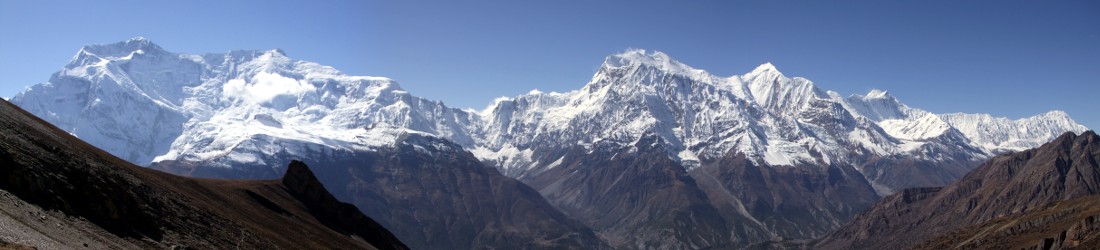
A long snow-capped ridge had appeared at the top of the valley ahead of us. I asked Santosh if the highest bump on its ridge was Dzo Jongo East, but he said that our peak was further around to the right.
Sandwiches eaten, we continued onwards and only walked for about 15 minutes before we were surprised to see the crew setting up camp on a grassy slope at around 5,100m. The kitchen tent had already been erected, and Imran was putting up our sleeping tent.
While they were finishing, Edita and I walked 45 minutes further up the valley to see if we could get a better idea of tomorrow’s climb. A more substantial peak had appeared on the snow ridge to the right of the minor bump I had seen earlier. If this was Dzo Jongo East then it was going to be no easy walk up. The only way to access it appeared to be up and over the smaller peak and along a narrow ridge of ice all the way to the summit. It would be one hell of a long day.

We crossed some boulders and the valley flattened out. Just beyond, we reached a flat area of wet sand that had clearly been used as a campsite by many groups. Lines had been drawn in the sand and rocks were piled neatly. Although it was closer to our mountain, it was nowhere near as nice a campsite as ours and there wasn’t much grass for the horses. I could see why our crew has chosen to stop where they did (though Santosh told us later that this sandy campsite had been closed by the authorities to give the area a chance to regenerate).
We could now see a third high peak up a gully to the right of this campsite. Access to the summit was up a gentle hillside that became a broad ridge, covered in snow, which could then be followed all the way to the summit. We checked the Maps.me app on Edita’s phone and realised that the two peaks on the snow ridge were Shaldor Ri (5,900m) and Gapo Ri (6,200m). Dzo Jongo East must surely be this new peak off to the right. It was directly above a popular campsite and matched its reputation for being an easy walk up. In fact, it looked like a piece of piss.
Edita suggested that we walk a little way up the hillside on the east side of the valley to get a better view of it. The river was wide here but shallow, and we managed to find a way across via a series of sand banks. We climbed about 50m up the hillside and now had a clear view of the whole route. It was straightforward. I could now look forward to tomorrow; it was going to be a nice easy walk, I was sure, though there was quite a bit of snow higher up.
We arrived back in camp at about 2pm. Santosh looked at our photos and confirmed that we had correctly identified Dzo Jongo East. We agreed an early start for the climb, but not too early. We would meet for a 4am breakfast and head out after that.

There was an afternoon snow shower that sent us sheltering in our tent. As we hunkered down, Edita and I sorted our kit for tomorrow. We could see from the amount of snow that we needed boots and crampons. We were surprised when Santosh said that we needed harnesses for the snow ridge because it was a glacier and we needed to rope up, but that we didn’t need axes as the ridge was gentle. If it was a glacier then an axe would surely be useful? If anyone on the rope fell into a crevasse, then a trekking pole wouldn’t be much help to stop being pulled in behind them.
At dinner Edita told the crew that she was afraid to go to the bathroom because they had pitched the toilet tent over a marmot hole. She was concerned that a marmot might pop its head up while she was going about her business. Santosh found this hilarious. He reassured her that it was an old marmot hole that was no longer being used. He knew this because there were no longer any scratch marks around the hole, which there would be if marmots were still going in and out. The reminder that marmots had created the hole by scratching didn’t make Edita feel any more comfortable.
My alarm woke me at 3.30am that night. All my kit for the day was neatly stacked beside my mattress so that I could just put it on. My boots took the longest. After wrestling with each one for five minutes apiece and straining every sinew I was eventually able to pull them over my feet and was ready for another lie down. Why does putting on a pair of mountaineering boots have to feel like you’re bench pressing 90kg?
By 4am I was ready. After lying back on my Thermarest for a moment or two and taking a few deep breaths, I went to the kitchen tent for breakfast. But the crew weren’t ready. Santosh sent me back to my tent and said he would bring our breakfast to us. So Edita and I waited inside the tent with our boots on (hell would need to freeze over before I took them off again).

Eventually we were ready to leave for Dzo Jongo East at about 4.45. Four of us set off, with Santosh leading, followed by myself and Edita. Imran once again showed his versatility, this time playing wicket keeper by bringing up the rear. The ground was frosty but we were well wrapped up for the cold as Santosh strode into the darkness in the direction that Edita and I had taken the previous afternoon.
After about half an hour I realised that he had veered to the right of the valley and was heading towards the moraine that guarded the route up Dzo Jongo. A steep trail wove back and forth on grey sand. Within about twenty minutes of it steepening, I made a schoolboy error. Santosh was quick, and instead of plodding at my own slow pace behind him, I tried to keep up. This caused me to work up a sweat that soon cooled down. From being nicely warm I began to shiver. It was three years since I’d last done a summit climb like this, and my inexperience was showing. Behind me, a wiser Edita was going more slowly. I dropped to her easier pace.
There was now enough light to turn off our head torches. We climbed above the grey moraine onto a drier rib of red sand. The sun rose behind us, lighting up the Nimaling valley far below and turning the river into a silver string. The tedium of the cold night climb had ended quickly and I could now enjoy the scenery. We were lucky with the weather: it looked like it was going to be a clear, sunny day.
About two hours after leaving camp we climbed high enough to get our first view of Dzo Jongo East. It coincided with us reaching the snowline. Dzo Jongo’s black isosceles triangle, streaked with snow, reminded me of a mini version of Gasherbrum I. We were now traversing beneath a snow ridge — the same ridge we had seen the previous day leading all the way to the summit. To the right below us, a glacier thick with snow spilled from beneath Dzo Jongo’s triangle.

Yesterday’s snowfall had given the mountain a wintery feel. Santosh led the way across this snow for a short while, contouring beneath the ridge, then he turned up to gain the top of the ridge. Happy to save weight, I had taken his advice (against my better judgement) and left my ice axe back at camp. Now we found ourselves zigzagging up a steep snow slope carrying only our trekking poles. I wondered what would happen should one of us fall. It would have been hard, if not impossible, to arrest before tumbling over cliffs to the glacier. Fortunately, we all kept our feet.
Once on top of the ridge we were on safer ground. Wind had scoured the snow off the top and we looked to be facing a pleasant ridge walk for a few hundred metres, curling gradually to the left before turning abruptly right to rise up the edge of the black pyramid.
In reality, the ridge rose steeply; we didn’t have much time to admire the view before we were facing into its slope and plodding relentlessly. We followed Santosh over a series of humps as we climbed higher up its length. There were several falls of fresh snow that we had to zigzag up. We now had a better of view of Shaldor Ri and Gapo Ri, the peaks we had seen the previous day. They were more snow-capped now, but they weren’t particularly arresting to look at from this direction, just the two highest of several points on an extended ridge.
Then we were at the base of the black pyramid. By Edita’s GPS we could see that there was another 400m of ascent. The summit was now in cloud. We were still on rock, but Santosh said that we might have to put on crampons and use a rope near the top in order to cross a glacier.

To our right the ridge was now sheer, tumbling down the precipitous sides of the black pyramid. For the remainder of the climb we kept well below it on the left side. It became quite a tedious ascent. We trudged through newly fallen snow, though I could see that the route would normally be rocky. Jagged boulders protruded from beneath the powdery carpet and the terrain was awkward underfoot.
Another broad, snow-topped glacier appeared far beneath us to our left. Above, fine clouds drifted across the higher reaches of Dzo Jongo, threatening the view. We stopped occasionally for rests, but there were no flat places so we simply lay across the slopes for a few minutes before moving on.
Eventually we could see prayer flags above us. The summit was clear again so we pressed on with more urgency to try and get there before another cloud swept across. We reached the summit at 10.45 after six hours of ascent. There had been no need for a rope or crampons. Where was the glacier?
We could see the ridge continue down and then back up, over the same familiar terrain of ankle-twisting rocks dusted in snow to an almost identical summit: Dzo Jongo West that we would be climbing in two days’ time. We could reach it now with only a couple of extra hours’ plodding over the same terrain. We even discussed this option, but Santosh wasn’t keen. He had never traversed across to it from this side and didn’t know if there were any difficult steps.

Instead, he described the route up from the other direction. The right-hand side of Dzo Jongo West was far more heavily snow laden than the summit we were standing on. It could be reached from the same glacier that had been our constant companion to the right since our first sight of the summit as dawn was breaking. It was now far beneath us, and we could see that it rose in a continuous sweep up Dzo Jongo West’s right-hand side, all the way to the summit. It was going to be a more alpine climb than this one, another reason to delay our ascent and provide ourselves with some variety.
We stayed on top for 45 minutes and had our packed lunches. Santosh (a Hindu) and Imran (a Muslim) attached Buddhist prayer flags between two cairns. When I questioned him about it, Santosh explained that prayer flags are auspicious to followers of all three religions. I took out my GPS and measured the altitude at 6,220m. We were also able to see Kang Yatze’s ascent route from a different angle, this time forming the right skyline of another ice-streaked triangle — it still didn’t look any more tempting and appeared to be just as steep.
It was a rapid descent. Imran led the way initially down the slopes of the black pyramid. The snow was already melting and jagged rocks were surfacing. Again, there was no sign of any glacier on the route and I’m now convinced there isn’t one.
We took a rest at the bottom of the black pyramid. It was now warm enough to remove my down jacket. I led the way almost non-stop thereafter, resting only once beneath the snowline. It was a slow plod, but we made good time and reach camped at 1.45 after exactly nine hours up and down.

We had a bit of a shock when we found that one of those massive Indian groups with 30 clients had arrived and taken over our lovely peaceful campsite. There were 15 sleeping tents, 4 big kitchen tents and 3 toilet tents. Somewhat unnecessarily given the amount of space in that wide valley, they had completely surrounded Edita and my sleeping tent, pitching those of their clients only two or three feet away. Santosh and Imran helped us to lift our entire tent with all our equipment still inside it, and carry it fifty metres away so that we had some peace and privacy again.
We rested for a couple of hours in the afternoon and recovered some of the sleep from our early start. At dinner Santosh gave us another surprise when he described our plans for the next two days. We would need to carry loads up to high camp, which meant that we had to minimise what we took with us. We had been expecting the horses to carry all our stuff up for us, so this came out of the blue. We had only 35-litre day packs, and would need to have sundry items dangling from our backs like the Hanging Gardens of Babylon. Santosh explained that the horses would not be able to come because we were camping on a glacier, and they were not very good with crampons.
We were even more confounded when he said we would need our jumars because they would be fixing 300m of rope. We had seen its glacier sweeping up to the summit, but it hadn’t looked too taxing, and wasn’t Dzo Jongo West supposed to be another easy walk up with just a little technical section near the top?
But anyway, we now had one summit in the bag and had accomplished it with very little fanfare. We just had two more tough days to complete and then we could take it easy again. Jumars aside, the climb looked pretty straightforward. What could possibly go wrong?
Continued in part 2: Dzo Jongo West: the world’s shortest 6,000m-peak summit day?.
You can see all photos from our Dzo Jongo climb in my Markha Valley Flickr album.


Wow your adventure is really a worthy to ready ..
Feels like I was with you guys while reading your blog
Hats of to you guys
Seems like santosh is amazing guide
Hoping for more vlogs on adventure on future
What boots were you wearing on this trip mate? Would you recommend double boots for a trip up to DZ East in September?
La Sportiva Baturas. Yes.