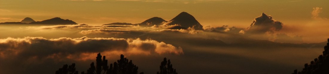

This is the fourth and final post in a series about my recent visit to Ladakh in northern India, my first foreign holiday after the COVID-19 pandemic.
In my first post I described the start of my trek up the famous Markha Valley. In my second and third, I whizzed up 6,220m Dzo Jongo East and 6,280m Dzo Jongo West. In this post I recount our return trek up the Langtang and Chang valleys over two high passes.
Well, OK. Perhaps the title of this blog post is slightly over the top, but not by much. If Dean Martin can put exclamation marks in a song title, then I can do it in a blog post.
When I woke up inside my tent on the morning after our Dzo Jongo double header, I was very much looking forward to the final few days of relaxing trekking after the strenuous grind of the two climbs. But I didn’t realise quite what a treat I was in for.
Instead of crossing the Konmaru La and descending into the Indus Valley to pick up a taxi back to Leh, as traditional Markha Valley trekkers do, our plan was to extend the trek a little and take in some alternative scenery.
As I mentioned in the first post in this series, the Markha Valley forks into two rivers at 4,000m or so, just above the village of Hankar.

On our way to the Dzo Jongo peaks, we had taken the left-hand fork up the steepish Nimaling Valley with the rest of the Markha Valley trekkers. Had we taken the right-hand fork, we would have found ourselves following the Langtang Chu up a gentler valley that rises to a barren pass, the Zalung Karpo La. Beyond the pass the trail continues down a side valley to join the Chang Chu, another major tributary of the Zanskar River.
Our plan was to skirt around the north side of Kang Yatze, cross another high pass into the Langtang Valley and follow this route for four days to the village of Dat in the Chang Valley, from where we could pick up another road back to Leh.
This short extension to the traditional Markha Valley trek is highly recommended. It is much more remote than the Markha Valley; there are no villages until you reach Dat. Moreover, the scenery is ever changing, and we experienced something different every day.
Now some of you may be thinking the Langtang Valley is in Nepal, not Ladakh, you idiot. This is perfectly true (there is a Langtang in Nepal, not that I’m an idiot). In the Tibetan language, the name Langtang translates loosely as ‘to follow the yak’. There is a frequently told story of the Nepalese Langtang Valley, about a monk who followed his yak into the valley, where he came across its corpse lying beside a rock near the village of Langsisa. Not one for sentimentality, he skinned it and lay its hide on the rock to dry. The next morning he discovered that it had stained the rock red. The rock remains red to this day. In 2015, Nepal’s inhabited Langtang Valley was devastated by a landslide that was triggered by a 7.8-magnitude earthquake. The heartbreaking remains of this event are only too visible, as I discovered when I trekked there in 2017.

The Ladakhi language is Tibetan in origin. Ladakh itself is a Buddhist region known to some people as ‘Little Tibet’. I don’t know if Langtang means the same thing in Ladakhi as it does in Tibetan, but I mentally prepared myself for yaks galore as we ascended its higher reaches.
But first we had to get ourselves around the north side of Kang Yatze and cross another high pass. This section, on the day after our ascent of Dzo Jongo West, was as spectacular as trekking gets.
After a lazy breakfast in the sun, gazing down the valley, we slowly packed our things away and left at 10.30. It was blissful, walking in fine weather at a leisurely pace and carrying only a light pack. But things were about to get much better.
We stopped briefly at the tented compound of Nimaling for Santosh to belatedly pay our permit fees for the two Dzo Jongos. He explained that the land around here is owned by Hemis Monastery on the other side of the Konmaru La, a popular tourist attraction (and Buddhist centre) with a museum that we had visited while we were in Leh. The warden of Nimaling was paid by the monastery to look after camp, and trekking was a good source of income for them. He agreed a price of 16,000 rupees (or around $160) for both peaks.
With our paperwork completed, we followed a trail up the hillside on the west side of the valley. After about 300m of ascent we arrived on a plateau and a grand vista of Mallari Ri, Dzo Jongo and Kang Yatze opened before us. On the opposite side of the plateau we could look up crinkled, snow-clad cliff faces to the opposite side of the col we had edged up the previous day on slopes of solid ice. Above it was a smooth, blank wall of snow. It looked sheer, but we knew otherwise — it was the same slope we had ascended in a whiteout. We must have stopped about halfway up. Above our turning point, Dzo Jongo West presented no further obstacles, though it obviously became steeper. I zoomed into it with my camera and took a snap for posterity.

We also had a closer view of the tiers of seracs on Kang Yatze I that we had planned to climb. They certainly made me gulp. Edita and I ambled slowly, stopping for many photographs.
We rounded another hillside and the view became better still. We looked down onto the red tents of Kang Yatze base camp, nestling beneath the mountain’s towering walls. Santosh was waiting at a riverside just below this and we stopped for a packed lunch as an agile brown stoat scurried around the rocks, eyeing my sandwich.
We could now see the whole of the ice face below the serac tiers and between ABC and high camp that we had been unable to see until now. It looked very steep, with a few streaks of rock where the snow had avalanched off it. Santosh explained that the route from ABC to high camp went from right to left beneath a black rock face that swept across the mountain all the way up to the summit ridge. There appeared to be some objective danger on this section of the route. A huge serac hung above the rock face. It was obvious that great chunks of vertical ice must sheer off it from time to time, right onto the route.
It was the sort of peak that I would prefer to climb with a bigger group such as Altitude Junkies or Jagged Globe rather than two guys and a rope. This is not to take anything away from Santosh and Imran, They were the right guides for Dzo Jongo. They saw that Edita and I were safe enough climbing the ice slopes below the col. We were able to climb rapidly unroped, but they set up an abseil for the descent. This common-sense approach doesn’t always happen in a bigger group, where guides are understandably more cautious. In a larger group, the guides might have decided to belay their clients one-by-one, which would have made for a long and tedious ascent. On a more serious and substantial peak like Kang Yatze I, however, a larger group provides extra security and support, and is a safer option.

In contrast to Kang Yatze I, Kang Yatze II looked a breeze, though perhaps quite a physical challenge. There was a place for an advance camp at the top of a small hill that led onto the glacier, but Santosh explained that most people climb it from base camp, about 1,200m below. From the top of the hill it’s just a long boring plod up a sloping glacier to reach the summit. The summit itself didn’t look very distinctive either, just a rocky bump at the end of Kang Yatze I’s summit ridge, though perhaps it feels like more of a summit when you’re standing on top of it.
I was becoming more convinced than ever that we made the right decision to climb the two Dzo Jongos, East and West, with their contrasting challenges.
The day’s treats hadn’t finished, and the best was yet to come. We rounded yet another hillside to gaze upon Kang Yatze from a new angle. We had reached the north side and were now looking up the giant snow face of Kang Yatze II, with the rocky ridge of Kang Yatze I rearing up behind it. The twin summits now looked more distinct.
To the right of Kang Yatze II was a gentle scree slope, the Konka Nongpo La that we would cross the following morning to join the Langtang Valley. A hundred metres or so below us we could see our crew pitching camp in a grassy meadow. We arrived there at 3pm.

What a campsite it was — right up there with my favourite ever camps! Not only were we right beneath the north face of Kang Yatze, but the view on the other side was magnificent too. Our slanting valley dropped steeply towards the Markha Valley, and beyond it we could see line after line of jagged rock peaks disappearing into the far horizon.
At dinner, I surprised our crew with a question.
‘If a dzo is a cross between a yak and a cow, what is a jongo?’
They looked at me blankly, as though I were asking a riddle.
‘A dzo, cross between yak and cow,’ they replied. This is a fact, rather than a riddle, in the same way that a mule is a cross between a horse and a donkey.
‘I know, but what is a jongo?’ I said again.
Nawang, our Ladakhi horseman, who did not speak much English, piped up. Santosh and Imran conferred with him.
‘Female yak,’ the answer came back.
‘Isn’t that a nak?’ I said. ‘What about a jongo?’
‘A what? Not heard this word. Where did you hear it?’
‘Well, it’s the name of the peak that we climbed, Dzo Jongo.’
‘Ah!’
Everybody laughed. They agreed that it was a very good question, but they didn’t know the answer. Despite climbing the peak dozens of times, it seemed that nobody had ever asked them this question before. Santosh promised to make enquiries when we returned to Leh. (I never did get the answer; if anyone knows then please post in the comments and I will owe you some chang.)
The following morning we had an al fresco breakfast at 7.30 looking up at the north face of Kang Yatze. It was much less forbidding from this side, but I still had no regrets.

As we waited for our crew to break camp, Edita and I sat on a bank watching the pikas scratch around. These mini mammals, about the size of a clenched fist, are somewhere between a mouse and a rabbit in design. They are everywhere in these mountains, a feature of every campsite we stayed at above 4,500m. They are sociable and quite accustomed to humans being around, but also a little grumpy with each other. Occasionally two came into conflict and there was a brief scuffle as they took swipes at each other with their front paws. We also saw the distinctive outline of a lammergeier flying high, white under its huge wings with black wingtips.
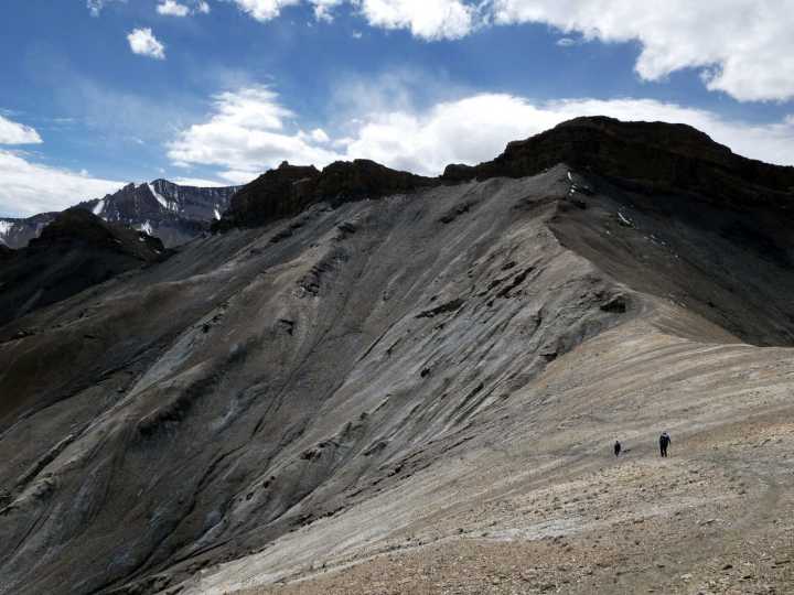
At 9.30, Santosh, Edita and I started the walk up to the Konka Nongpo La, the pass we could see directly beneath the shoulder of Kang Yatze II. It was just above our camp and very gentle from this side. We plodded slowly up grassy slopes into terrain that became gradually more barren, until we were walking over scree.
At the top of the pass we looked down into a much narrower valley which descended steeply. In stark contrast to the slope we had ascended, it was almost a gorge. Beyond it we could see wave after wave of rocky ridges, dry and red, with not a speck of life. I got out my GPS and measured the altitude at 5,160m, again considerably higher than the altitude marked on the map. We were high enough to see behind us across the Nimaling valley to the Konmaru La, the other pass that we climbed a week ago.
We waited for the horses to catch us, then followed them down the other side of the pass. The trail was steep and precarious, and a couple of the horses with heavier loads seemed nervous, treading carefully. Our horseman Nawang led at the front, which meant that Imran and Tukten needed to do quite a lot of work driving of the reluctant ones from the back.

Edita and I ambled slowly, stopping frequently. We didn’t want to walk too close behind the others because it was dusty and the horses conjured up clouds in their wake. Gradually the precarious path that traversed above a ravine became less distinct as it crossed more rolling hillsides. Patches of tufty grass appeared. We stopped to watch a flock of blue sheep, then stopped again for packed lunch on a rock, finally letting the horses get ahead. Our lunch stop gave us yet another view of Kang Yatze. It wasn’t as pretty from this side; there was less ice and it was more of a rock climb.
After lunch we dropped down into the Langtang Valley, a continuation of the Markha Valley where we had started our trip. We descended to as low as 4,400m. Tangled shrubs sprouted from rocky outcrops as we followed the river upstream.
At 2pm we saw our crew pitching camp in a flatter area across the river. We crossed boulders to join them. The valley was narrow with high walls, but we were camped in a more open section where a side valley came down from Kang Yatzes III and IV. Our tents were pitched on a prickly heather-like plant and the ground was quite rough underneath. The altitude was 4,500m. It was sweltering when we arrived, but soon became cooler as the sun dropped behind the valley walls. We washed from bowls of warm water and settled in for an afternoon in the tent.
The next day was our longest day of trekking aside from the two summit climbs. We had 700m to ascend to the next pass, the Zalung Karpo La. We ended up being on the trail for 7 hours (which isn’t so much in the big scheme of things, but it had been a trek of very short days until now).

It had also been our least pleasant campsite in terms of size and roughness, although we slept well enough. The lack of space meant that we ate our breakfast just a few metres from the place where the horses were tied. We could hear them farting away, which was amusing enough at first, but a dark one at the end of the row was going at it non-stop. Luckily we finished eating and were packing the tent away when the horse in question started to let rip in more odorous fashion. The crew found it hilarious as we waved our arms around to waft the air away, grimacing furiously. We decided to name this horse Donald Trump after the colloquial British term for breaking wind.
As the crew loaded the horses, Edita and I sat on a large rock in the middle of the river, looking downstream. We left with Santosh at around 10 and ambled slowly up this enclosed valley.
I had burned my lips during our last summit attempt. It was painful for me to eat and drink hot food and liquid, and the constant sun, all day, every day, meant that my lips were getting worse, not better. Edita suggested that I walk with my buff pulled up over my mouth to prevent any further burning. It was difficult at first as I’m used to breathing through my mouth as I walk, and I walked even more slowly as I became accustomed to it.
This was OK because there was no point in walking any quicker than the horses. They passed us early on (Donald no doubt powered by methane). We stepped off the trail and sat on a rock. As we waited, we watched a large flock of blue sheep skitter across steep rocks high up in a narrow part of the valley.

The ascent to the Zalung Karpo La was gradual. We barely noticed we were climbing at first. Then the vegetation thinned and the trail steepened. In the latter stages, we found ourselves ascending into a barren moonscape of red pebbles, with not a single shred of grass to be seen.
The apparent top of the pass appeared suddenly around a bend. We could see the horses disappearing over the horizon between two large cairns. But no. This turned out to be a false summit. Beyond the cairns, the moonscape continued relentlessly into another combe of rolling pebbled hills.
When I finally reached the pass at 1 o’clock, I was a long way behind the others. The top was a desert landscape of rounded tops that reminded me of Maiella in the Italian Apennines. But where Maiella rises to a little under 3,000m, here we were over 5,000m again. More significantly, to the north-east we saw five towering snowcaps — the backside of the Kang Yatze massif. Mountains have a habit of looking completely different from opposite sides, and none of us were able to identify which peak was which.
Looking beyond the pass to the south there were some rather severe rock spires that would have extreme rock climbers licking their lips (I was merely gazing in awe). There were no names marked on the map and Santosh said that he didn’t believe any of these peaks had them.

We sat on a pebbled slope just beneath the crest of the ridge and ate our lunch. My altimeter read 5,200m. On the other side of the pass the trail was more precarious and it must have been a job getting the horses down it. A narrow path descended steeply down dusty slopes, twisting around hillsides until it pointed south and dropped down into another narrow valley similar to the one we had just ascended.
After a steep initial drop, the trail and valley levelled out and we joined a river. There were many river crossings as the path veered from left to right across the steady flow. Fortunately the river was not so powerful yet and we were able to find suitable stepping stones at each crossing point.
Gradually the vegetation started reappearing, but it was a long time before there was anywhere suitable to camp in the rough, dry terrain of this steep-sided valley. But then, lower down, we started passing through a profusion of magnificent campsites — flat, grassy areas in wide open spaces, with small shrubs and a river nearby. Each time we reached one I wondered why our crew were not here pitching camp. It seemed too good an opportunity to miss.
I was also troubled by my bowels and could no longer wait until we reached camp. I had to stop and relieve myself in a patch of sandy scrub. I must have lost several kilos by the time I finished, and I had to erect a small cairn to cover it, much to Edita’s amusement when I told her about it.
Finally, at 4.30 we rounded a corner and bumped into our crew pitching tents. It was a smaller area than some of the sites we passed earlier, but it was just as suitable. And its size eliminated the unlikely possibility of a giant trekking group stopping here and encircling our tents with their own, as they had at Dzo Jongo base camp. It was certainly a much nicer spot than the place we stayed the previous night. We settled in for our penultimate night of camping with just one more long day of walking to go.
Then, at approximately 7.45pm Ladakhi time, we witnessed one of the strangest things I have ever seen. We were sitting together in the kitchen tent drinking tea after dinner when Santosh got up to walk outside. A moment later we heard his voice.
‘Hey, everybody. Come outside now. Come and look at this.’
We all scrambled out. It was pitch dark and I expected to see shooting stars lighting up the night sky, but it was far stranger than that. Almost directly overhead, a line of about twenty lights like a necklace of beads was moving slowly at an even pace. The distance between each light never varied and they stayed in a perfect line until we watched them disappear behind a cloud.
The regularity couldn’t possibly be natural — it had to be man-made — but what on earth was it? I have never seen or heard of twenty satellites circling closely like that. Was it twenty aircraft flying in formation? But in that case the pilots were managing to do it in perfect unison. Or was it a single vehicle with twenty lights along its side? In that case, it must be enormous and shaped like a centipede.

I was at a loss for any plausible explanation. I had no idea how high up it was, but anyone looking into the night sky in northern India at that moment must have seen it. The answer had to be out there somewhere — or was it? I was acutely conscious that we were extremely close to one of the largest disputed territories in the world — vast mountainous areas claimed by India, Pakistan and China. If this was one of those countries conducting manoeuvres then they weren’t being very subtle about it.
Of course, there was another explanation, one that was doubtless circulating already on numerous Facebook and Reddit groups.
‘If any aliens turn up during the night then please wake us up,’ I said to our crew as we left the makeshift dinner table to return to our tent.
Everybody laughed.
‘I’m serious,’ I said (except, of course, that I wasn’t). ‘We don’t want to wake up tomorrow morning and find you’re not here because you’re halfway to Mars.’
The final day of our trek turned out to be another day of breathtaking surprises, and the fourth consecutive day of ever-changing scenery.

It was a cloudy morning and the overcast conditions persisted for most of the day. The walking was much easier without the sweltering heat. Edita and I set off on our own at 9.30 and continued to follow the same broad valley that we came down yesterday afternoon.
After about half an hour of easy walking, the valley slanted to the right and the river appeared to disappear down a hole. We were following the right-hand bank which also looked like it was about to become cut off by tall cliffs. There seemed to be no option but to cross the river. Until now there had always been stepping stones to allow a passage across without getting wet feet. But here the river was wide and flowing and there were no such stones available.
Edita took her shoes and socks off, rolled up her trouser legs and waded across barefoot. The soles of my own feet are not so hardened to stony riverbeds, and I preferred to keep my shoes on, though I took my socks off to keep them dry.
As I was sitting on a rock, drying my feet, I saw a man high up on a bank our side of the river who had been watching our performance. Where had he come from and was there a village nearby? He started to walk down towards us, but at that moment the rest of our crew appeared with the horses. The horses waded straight across, Santosh jumped across at the same point Edita and I had, but Tukten and Imran didn’t cross at all. Instead they continued on the right-hand bank up a narrow path that we hadn’t noticed, then disappeared behind the same bank the stranger was standing on. When we climbed this bank ourselves we realised that the river disappeared underneath a natural bridge in the rock and emerged the other side. Tukten and Imran had simply walked straight across this bridge onto the other side of the river.

I felt a bit of a fool. Santosh was laughing when he saw us emerge. But actually the laughs were on all of us. What we didn’t know at that stage was that it was going to be a day of many river crossings. The only person who managed to avoid wet feet was Nawang the horseman, who jumped on his spare horse each time.
The path dropped down towards a gorge. Over another brow we saw a white tent pitched in a field, belonging to the man we saw earlier. We could see another man with a walking frame hobbling towards it. At the tent, the first man offered us some tiny apples to eat. Santosh and Imran were busy talking to him. Santosh pointed to a natural spring emerging from a rock in the cliff face on the opposite side of the river. He explained that the spring was believed to have healing properties. The man with the walking frame was here to bathe his leg in the waters of the spring until the leg was healed.
We wished him luck and continued on. A short distance beyond this, just before the trail entered the gorge, we encountered our second river crossing. I noticed that Nawang had ridden across, but Imran and Tukten were on the other side, putting their shoes and socks back on. I took my socks off again, but now they were wet from the first river crossing, it occurred to me that there wasn’t much point.
Across the river we continued down into the gorge and entered a delightful willow grove dwarfed by towering red cliffs on either side. There was another river crossing. Once again, Imran and Tukten were on the opposite bank putting their shoes on. It was déjà vu.

‘Bugger this,’ I said in a loud voice, a grumpy expression written across my face. I didn’t even stop to roll up my trousers legs, but waded across with my shoes and socks on. The others roared with laughter.
A short while later we reached a confluence of rivers meeting at a Y shape beneath the towering cliffs. A slightly more open area was carpeted in yellows and greens of tiny willow. On the map it looked like we would be joining a much larger river, but ours was just as big. I also assumed that we would be continuing downstream to Dat, but as we took a left into the adjoining gorge, I was surprised to see that we had turned upstream to walk alongside a much smaller river, a tributary of the Zanskar marked on the map as the Chang Chu.
If the Langtang Valley where we started the previous day was named for its yak pastures (we hadn’t seen any yaks), I wondered if the Chang Valley was named after the Tibetan beer made from millet, drunk in great quantities in Nepal and also available in Ladakh. But Chang, the beer, is milk white, and this river was deep green. So probably not.
The next two hours were enchanting. Despite being hemmed in by red cliffs on both sides, the willows had found plenty of light. The Markha Valley that we’d ascended at the start of our trek was a fertile oasis of green in an arid land, but that valley was populated and had been heavily irrigated by people over the centuries. There was none of that here, and it was oh so strange (and a little magical) to be walking through forest in this narrow desert gorge.

We had one more river crossing then continued on the right bank, either on a scree path above the bank or down in the heart of the willow groves. At one point we passed a small rock pool that had become something of a graffiti corner in this remote part of Ladakh. There were some colourful runes, and somebody had inscribed the following message in a calligraphic script.
‘Peace. Love. Understanding. Let this be our religion, by P. Namgyal.’
‘Didn’t John Lennon say something similar?’ I said. ‘Or was it Elvis Costello? Anyway, I’m not sure Peter Namgyal has copyright.’
We emerged from the gorge into wide open grasslands; the willow groves dwindled, then vanished, which again seemed counter-intuitive. It now felt like a scene from the Wild West. I imagined cowboys riding towards us on horses. The tall cliffs remained, but now they were more distant in this expansive landscape.
We passed a ruined fort in an eerie setting. Threadbare, tangled prayer flags fluttered from its walls. Towers were piled high with blue sheep horns, which gave it the aura of a graveyard. We walked quickly on and the grand vistas soon put our thoughts elsewhere. We could see miles of unbroken grasslands ahead of us, framed by arid mountain walls. The Chang Chu had trickled away somewhere to our left and was barely noticeable. I estimated the valley to be a mile wide in places. After several hours of delightful walking we sighted mani walls on a hillside ahead of us and a short distance later we descended into the village of Dat.

It was 3pm and the village was a big surprise. There were some traditional stone buildings but the place was dominated by prefabricated cream huts. It felt like a scientific research station somewhere in the Arctic wilds. Santosh explained that the huts had been provided by the government. Because the village was located at the end of the road, it was an important outpost. There was even a monastery.
We walked through the village. At the far end was a rickety old building where our horses were being unloaded. It was signposted as the medical centre, but the building looked abandoned and the grounds were a dump. There was litter everywhere. It was a shock. A few minutes ago it felt like we were miles from anywhere. There were a million places to camp in complete isolation, surrounded by nature. But we had ended up here.
Santosh and Imran pitched our tent against a concrete hut. But once inside the tent it was still impossible to forget our surroundings. We were a few metres from the road and vehicles drove past often, sounding their horns. Later in the afternoon, our little camping spot became a noise fest. We heard two vehicles idling on the road just a few metres from us. There were many voices talking for a long time. We wondered what was going on.
Edita stuck her head out of the tent. Someone was pitching an Ozark tent a short distance away. Santosh explained that our driver had arrived from Leh with a minibus. The tent was his, and he would drive us back to Leh the following morning.
Our trek was over, but what a magnificent one it had been. Our crew of four were among the best I’ve had for a camping trek anywhere in the world, and we again had Jamie from Project Himalaya to thank for putting together a great itinerary. The last four days were the icing on the cake.
You can see all photos from our trek and climbs in my Markha Valley Flickr album.


“I have never seen or heard of twenty satellites circling closely like that.”
Elon Musk’s Starlink sattelite train ?
Heavens above, you’ve got it! It was just like the top photo here:
https://earthsky.org/space/spacex-starlink-satellites-explained/
Mystery solved. Thank you!
Hi Mark ,thanks for taking me back to that eerie, sterile landscape around Zalung Karpo La. You had me fooled about doing four days in Langtang! ( also thought of Nepal). You also put me onto the Starlink, something I didn’t know about. Glad you had an enjoyable trek up till the last camp at the dump. Nice photos and write up, surprising amount of wildlife there considering the barrenness. I saw a group of chittal deer right by Hankar and met a trekker who had eye contact for ten minutes with a snow leopard near mentioned pass. Best wishes
Hi Mark. Thanks for the great descriptions. Did the Markha Valley trek a few years back.
Do you think it’s possible to walk from Markha to Dat without a guide? Is the trail easy to follow?
I noticed there’s now a road up to Markha. Is there any traffic on this road? How relatively unpleasant is it to walk on? Are they extending it up beyond Markha?
Thanks!
It’s a 3-day hike from Hankar to Dat with no villages, so I would recommend some sort of support. I don’t remember seeing any vehicle traffic beyond Sara.
Thanks. Did you see many people on the Hankar – Dat path, apart from at the spring?
No one, just us.
Thanks!