
This is part 3 in a series of posts about our Chimborazo sea to summit adventure. See here for part 1 and part 2.
We had cycled from sea level at Guayaquil and circled Chimborazo on foot, climbing Carihuairazo on the way. It wasn’t the most direct way, and there may not be many others who follow in our footsteps, but it had been fun. We had just one more task to do: to climb to the summit.
But first we had a rest day, only our second of the trip. I had improved a lot since my collapse by the roadside six days earlier, and on Carihuairazo I felt strong, but a rest day would do us both some good.

Javier drove us a short distance down the road to the Marco Cruz Chimborazo Lodge, in a grassy valley beneath the south-west face of Chimborazo. By our rules, as long as we started again from exactly the same place, Carrel Hut, then it wasn’t cheating (though perhaps somebody needs to write the rules for this game).
I could see why Javier had chosen this place for our rest day — it was like a museum. The dining area comprised a single room made of wood, with long wooden tree trunks as beams. It was owned by Marco Cruz, the grandfather of all Ecuadorian mountain guides (metaphorically speaking, not literally — that would be ridiculous). The walls were full of his old climbing equipment. There were ancient crampons, ropes and carabiners; and old mountaineering boots were being used as flowerpots. There were also photos of the various plants of the páramo, black and white photos of Chimborazo from various angles, Whymper engravings, and historical photos of climbers. Marco Cruz must be important, because in a photo of him and Reinhold Messner, the great Tyrolean alpinist was sporting a rare smile.
We spent a day and a half there, resting and doing nothing else. The staff kept a wood stove burning as we sat and read our books. Chimborazo appeared briefly in the morning, but for most of the day it remained hidden behind cloud.

The next morning Romel Sandoval, our guide for the Chimborazo climb, arrived to take us back to the Carrel Hut, where we would remain until we climbed the mountain (or not, as the case may be). We knew him well. He was our guide when we climbed Chimborazo last year. I expect he was hoping I was in better shape than I had been then.
He suggested a little acclimatisation hike up the Whymper route that afternoon to examine the conditions. This was the route we were hoping to climb, so named because it was the one taken by Edward Whymper, Jean-Antoine Carrel and Louis Carrel on the first ascent of Chimborazo in 1880. Romel had climbed the route with his girlfriend a few weeks earlier, but there had been a lot more snow then; now conditions were drier and there was more rock.
If not the Whymper Route, then there were two alternatives. We could either take the west ridge beneath a fortress of rock called El Castillo. This was the route we took last year. We knew we could do it that way, but it was long and we fancied a change. The second alternative was the normal route, straight up between the other two routes from the Whymper Hut. It was shorter, but it was known to carry a significant rockfall risk.

We drove up to the Carrel Hut and grabbed bunks in the dormitory. My appetite had returned completely. I didn’t have any problem wolfing down a large pork chop, and after lunch, at 2.15, we set off to walk up to the Whymper Hut. It was cloudy, but we hoped the clouds would clear to let us have a look at the route.
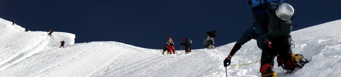
We saw a figure high above at the Whymper Pinnacles, a set of — yes, that’s right — pinnacles jutting up from the south-west ridge. We continued above the hut and reached the pinnacles at 3.45. We were now at 5,200m, and it had taken us only an hour and a half to climb 400m.
Suddenly, just as we were sitting having a snack, we saw a large rock crash down the ridge above us. It fell right across the trail and seemed to appear out of nowhere. Was it dislodged by the figure we saw above the Pinnacles?
We put on our helmets and carried on. A short distance above, we met a Canadian climber who told us he was wandering up and down the ridge to acclimatise. He said he had been up the previous day when the sky was clear, and had lots of photos of the Whymper Route that he could show us.
We walked up to where the snow started at 5,400m, but the clouds remained firmly in place. It was 4.30. The walk had been good acclimatisation for us, but we were no nearer deciding which route to take for our summit attempt.

Back at the hut, the Canadian showed us his photos, and Romel thought the route might still be possible. The Canadian had been waiting at the hut for a few days, and he was in a state of despair that hardly anyone seemed to be reaching the summit. Many climbers were turning back with altitude sickness.
‘It’s a long day,’ I said. ‘You have to be fit and you have to be acclimatised.’
He may have been discouraged, but we had prior experience on Chimborazo, and we were encouraged that no one was being thwarted by the conditions.
That night I was woken often by people returning from their summit attempts. All of the night-time returns came back too soon to have reached the summit. In the morning we learned that nobody was successful that night. But it seemed that in all cases they either had altitude sickness or they were too tired.
It was a clear morning, and this gave us a chance to study the traverse from the Whymper route to the normal route. There was a lot of black ice. Romel didn’t think it looked promising, but he decided to go for a scouting trip to examine the traverse from a different angle.
He returned at midday after walking all the way up to the same point we reached the previous day. He said it looked much better from up there. He now thought there was a 60-70% chance of us getting through. Edita was excited about the prospect of climbing Chimborazo by a different route, and we agreed to give it a try.

We decided to leave from the Carrel Hut at 10.30 that night. If for any reason Romel decided the traverse was too dangerous when we got there, we would come back down, rest up for another day, then try one of the other routes.
We got up at 9pm on 26th September. The mountain was much quieter that day. We three, the Canadian and his guide appeared to be the only people heading for the summit.
We made sandwiches in the dining room and had coffee, bread and jam. We left at 10pm and trudged slowly up to the Whymper Hut under a bright half moon. We reached the hut at 10.45 and continued up to the Whymper Pinnacles, reaching them shortly before midnight.
It felt like a mild night, but it started to get colder when we reached the start of the snow and put on our crampons for the climb. I zipped up, put up my hood, and wore extra gloves.
We left crampon point (5,400m) at around 1am. The snow angled to the left across the west face. We climbed steadily, and I lost track of time. There was one steep section where the ice was hard and we had to use our front points, but we were soon over it.
After about an hour we stopped going upwards and traversed to the left. The angle was about 45º, but the ice was firm, and hard work for my right arm. In the back of my mind was the black ice section that we saw from the car park and I knew we would have to cross. This would be the crux of the climb; if we could get across it, there should be nothing to stop us reaching the summit.

We reached the end of the snow and began crossing the section that looked like a sheer cliff of red rock from below. Things can be deceptive when you look at them head on. It wasn’t a cliff, but a slope of around 45º. A layer of ice lay beneath, but on top was a surface layer of red pebbles. Only when this layer became thin and the ice poked through did the way become hazardous.
There was one dangerous move where we had to traverse across a section of diamond-hard ice. Romel crossed it easily, but Edita had more trouble. She faced into the slope and crossed it using the front points of her crampons. But the ice was so hard that she could only get a few millimetres of purchase with her toes, and virtually nothing with her axe.
She climbed upwards but got stuck on a vertical section of ice. Safety was a few metres below her to the left. I jammed my axe into the ice and leaned into it, bracing myself in case she fell. It wasn’t a strong stance and I was afraid I would be ripped off the face, but there was nothing else to do. I breathed a sigh of relief when she inched her way down and reached the safe area of flatter stones.
When it was my turn to cross, I understood the trouble she’d had. I eased my way across two steps. My crampons were held precariously by only a few millimetres of ice. I needed to whack hard with my axe to get any security for my arms. It was going to take an age to get across that way, so I decided to try another tactic. I would make a leap across to the safe area. It was only about a metre away, but jumping isn’t so easy when you only have two millimetres of toe to push with.

I managed a pirouette that wouldn’t have got any marks for style on Strictly Come Dancing, but it was enough to get across safely. Ahead of me Edita was having more trouble crossing a tricky pillar.
‘Edita, what are you doing?’ I heard Romel say. ‘There is an easier way. Just watch where I go and follow me.’
She climbed back down the pillar, and Romel directed her across a lower route. After this we had no more difficulties. I was surprised to discover there was no black ice, like there had seemed from below. Romel expertly picked a route which stayed on rock. Within half an hour of leaving the glacier on the Whymper ridge, we rejoined the ice on the normal route.
We had made it across the gap between, and although there were still a few more hours of climbing, I knew for sure that our sea to summit was in the bag.
Romel climbed a little further onto the glacier, then cut a platform or us to sit down. It was nearly 4am and much colder. My water bottles were frozen, but I didn’t care.
We climbed steeply up the cone of the volcano and joined the normal route, familiar ground from our ascent last year. Edita checked her altimeter. We were at 5,900m. There was much more snow than there was on our previous ascent, and it felt much safer.
We had two more monotonous hours ahead of us as we climbed steeply on the featureless snow cone, waiting for the sun to rise. But as the sky lightened, the angle of the slope lessened, and we stepped onto the Veintimilla summit at 6am. Last year the approach to this, the lower of two summits, was blocked by a field of penitentes, ice stalagmites that are supposed to resemble a procession of penitent monks, but only if you’ve been drinking. These weird ice formations come and go with the seasons, and are formed by the action of sun and wind on newly fallen snow.

But frankly, how they are formed is of secondary importance to the fact that they are a pain in the arse to cross. The only way is to weave an awkward route between them. Last year, below the Veintimilla summit this awkward route had been forged by previous climbers, but between the Veintimilla and Whymper summits it had not. That season, everybody but us had been cheating, and stopping at the Veintimilla. We had to blast through penitentes and break the trail to the Whymper summit ourselves.
But this time there were no penitentes anywhere. These ghosts of the snow had melted away. There was only a hard surface of crisp snow, and this made things considerably easier. We could see two black figures approaching the top of the Whymper summit. We took our packs off, unroped and completed the final section of the climb across the saddle to the Whymper summit as the sun came up behind it.
The Canadian and his guide returned past us as we approached the top.
I slapped him on the back, but he seemed too tired to respond. ‘Don’t believe the statistics,’ I said. ‘It’s 100% success rate from Carrel Hut tonight.’
We reached the Whymper Summit at 6.30. We were cold but elated. I hugged Edita and started jumping up and down shouting ‘sea to summit, sea to summit.’
The others got caught up in it, and soon all three of us were jumping up and down like a trio of clubbers at a rave. We must have looked like idiots, but luckily no one else was there to see us.

For the second time in as many years we had a clear view of all the volcanoes in Ecuador rising above a sea of cloud: Cotopaxi, Cayambe and Antisana in a line to the north, and the seldom-climbed big three of the south, Tungurahua, El Altar and Sangay. We were blessed to have the place to ourselves.
Edita asked me to take some summit video footage, but got upset when I started saying to camera that I’d been a sea to summit cheat by getting in a support vehicle during the bike ride. The cheating didn’t matter to either of us, but we had different reactions to it. For me, I had enjoyed the trip and it was great to be up here on the summit again, but if we were hoping to claim a first then we have to be honest about everything. Only one of us had completed the sea to summit challenge in its entirety, and it wasn’t me.
After fifteen minutes on the summit, we turned and left. I never expected I would be there again, and perhaps this really will be the last time.
Last year I remembered having something of an epic descent on a super dry glacier that dragged on for hours. This time it was much easier. There was more snow, but it was still unbearably tedious. We decided to descend by the normal route, rather than returning by the Whymper, but this decision proved to be a mistake. It was such a boring descent, down a steep and monotonous glacier.
Once back on the rock, we remained roped up with our crampons on. The mountain was crumbling, and it had crumbled considerably since our last ascent. There was a red cliff with rock the consistency of cheesecake, though not as edible. We descended it carefully, then traversed beneath El Castillo, a rocky outcrop on the west ridge. The terrain was unrecognisable from the previous year, and the trail had crumbled to nothing. Parts of it were sliding down the slope, and there was a lot of ice. We needed to take extreme care, and remained roped together
When we reached the safety of the firmer ridge, the Carrel Hut was still far below us, but this time we descended quickly. The terrain was awkward, but we didn’t stop. We reached the hut at 10.30, after 12½ hours of climbing.

I had found our climb of Chimborazo much easier than last time around, but conditions were easier and, more importantly, I was in better shape. We had been doing a lot more exercise, and we were well rested. But most importantly of all, we had climbed the mountain before and we knew we could do it again. So much of mountaineering (and anything in life) is in the mind.
I had not found the sea to summit adventure as a whole quite so easy though. The bike ride had taken me to the limits of my endurance. I had been found wanting, and had to take the support vehicle for a short distance.
But for Edita, it had been a complete success. She had cycled from sea level at Guayaquil, done a complete traverse of Chimborazo, then climbed to the summit. She had even done a short run from Carrel Hut down to the park gate. We don’t know for sure, but it’s likely that this is the first time this feat has ever been accomplished. She truly is a superstar.
In any case, whatever the achievement, we’d had a great adventure, and would be returning home with many happy memories of a fabulous country.
Outside Carrel Hut, some cyclists were preparing to cycle down the hill. They had been driven up in a bus, and their bikes were being unloaded from the roof. It seems to be a popular activity for tour companies to bring their clients here, to zoom down the dirt track to the park gate. A tour leader was handing out knee pads and elbow pads. I don’t know whether any of them were serious cyclists, or simple, everyday tourists on activity holidays. It’s wrong, I know, but I felt a gentle waft of superiority.
I can’t claim to be serious cyclist either, but I feel like a bit more of one after our North Coast 500 bike ride and our sea to summit adventure.
A big thanks to all our Ecuadorian friends who helped us along the way: Pablo Montalvo, Rodrigo Donoso, Marco Castillo, Romel Sandoval, and expedition mastermind Javier Herrera of Andeanface (not forgetting his wife Helma). We will return.


Nice work Mark and Edita. I will give you full credit for sea to summit in spite of your brief car ride while sick. Now I have one more item on my to-do list!
another great write up Mark and good on you both.
Thanks, gents. Robert, I can’t believe you’ve not been to Ecuador.
Nice storytelling and nice writing as always Mark. Someday it’d be fun to meet you. I used to guide this route a bunch in the 1990’s for the American company Alpine Ascents International, and it’s interesting how much it has changed since then! At the time I thought about doing a sea-to-summit, but never got beyond the thinking about it! Well done you two! Adventure on!