
This is the third and last in a series of posts covering our recent visit to the Isle of Skye and the Northwest Highlands of Scotland. The story began in my first post, The four summits of Sgurr a Mhadaidh and continued in the second post, The Dubh Slabs: the most iconic scramble in the British Isles.
In November 2007, I set out from Kinloch Hourn at the end of a 22-mile cul-de-sac in a remote part of Northwest Scotland, carrying a gigantic rucksack with 5 days worth of food, tent, sleeping bag, stove and all the camping essentials.
My aim was to walk to Inverie in Knoydart, a village at the end of a peninsula that is unconnected to the road network. Its isolated location means that it is more akin to an island than a place on mainland Scotland. Aside from the rough hiking trail that I would be using, the main route to the village is by boat. On the way to reach it, I intended to cross the Munros of Luinne Bheinn and Meall Buidhe, and for the return leg I intended to traverse Ladhar Bheinn (pronounced ‘Larven’), considered by some to be Scotland’s finest mountain.
I didn’t come close to realising my plan. I was carrying far too much stuff and while I had completed many 2 to 3-day backpacking adventures in spring or summer, I had vastly underestimated the conditions in winter, with fewer hours of daylight, colder temperatures and slower travel across snow.

I was freezing and exhausted when I arrived on the summit of Luinne Bheinn (pronounced ‘Loonya Ven’ and not, as you’re thinking, ‘Looven’ — though at that precise moment ‘Loony Bin’ seemed more appropriate). I was well behind schedule if I wanted to avoid walking in darkness. Somewhere on the other side of the summit I leaned against a rock and realised I was becoming hypothermic. There seemed little prospect of climbing the second Munro Meall Buidhe (pronounced ‘Meal Boo-ee’ — though right then it was more like ‘Meal Boo-hoo’). I ended up evacuating down a desperately steep gully, dappled with waterfalls, where a slip could have landed me in serious trouble.
I was single at the time, not working and had told no one of my plans. It may well have been several days or even weeks before anyone noticed that I was missing. Simon Ingram’s book, The Black Ridge, that I’ve recently finished reading begins with the story of Captain Maryon, a retired soldier who died somewhere on the side of Sgurr Hain, a rarely visited minor peak in the Skye Cuillin. It was another two years until somebody stumbled upon his corpse. The only evidence of my location in the world was my car parked at Kinloch Hourn several miles away. I could have become the next Captain Maryon. Happily I made it down safely and staggered into Inverie as dusk was falling.
For the second leg of our Scotland trip in May, Edita had booked a cottage in Lochailort on the ‘Road to the Isles’ west of Fort William, so named because there are more ferries to Hebridean islands from the port of Mallaig at its far end than there are hairs on a sporran. The Road to the Isles also passes through the village of Glenfinnan, a famous pilgrimage site for Scots having been the place from where Charles Edward Stuart, the Young Pretender, otherwise known as Bonnie Prince Charlie, began the Jacobite uprising against the English in 1745. There is an 18m high monument celebrating this historic event on the shores of Loch Shiel as you approach the village, but it’s somewhat overshadowed by the twenty-one 30m high arches of the rather more dramatic Glenfinnan Viaduct that pass behind it. Nowadays, 99.57% of visitors to Glenfinnan come because the Hogwarts Express choo-chooed its way across the Glenfinnan Viaduct in the Harry Potter movies.

Lochailort is neatly positioned for three Munros: the straight-up-and-down tick in the box of Gulvain, and the slightly more interesting horseshoe known as the Glenfinnan Two, which can be accessed by walking up Glen Finnan from the railway arches. South of Glenfinnan there are many more smaller peaks on the Ardgour, Moidart and Ardnamurchan peninsulas. Combining these with the coastal scenery around Mallaig and perhaps a visit to an island, there was plenty of us to do for a week, and we could reserve the best two days for the three Munros.
However, when I Iooked at the weather forecast after arriving at our cottage on the Saturday afternoon, I nearly fainted with shock. Sunday: blistering sunshine. Monday: more blistering sunshine. Tuesday: baking skies. Wednesday: phew, what a scorcher. Thursday: pack your bikini. Friday: record May temperatures. In short, there was plenty for Just Stop Oil to get excited about, and even more for Munro baggers such as ourselves. It was like being back in the Apennines. I’d never seen a forecast like it in all my visits to Scotland.
The coastal walks and island hopping would have to wait for another visit – the opportunity must be seized to go up Munros every day, but what to climb? The answer was obvious. Mallaig also happens to be the port from where you can catch a ferry to Inverie. We had no tent, but I knew of a bothy at Barrisdale Bay. It was the other side of Ladhar Bheinn from the village and I had camped there on my previous visit. It was a golden opportunity to make amends for my failure sixteen years earlier and complete the Knoydart Three, this time in glorious weather. I sprinted to the Western Isles Cruises website as fast as my fingers could carry me and booked our tickets.
And so it was that we arrived in Mallaig on Tuesday having bagged Gulvain and the Glenfinnan Two on Sunday and Monday. I’d read a post on the Walkhighlands website that suggested I could find free parking on the harbour front just beyond the ferry terminal. I was worried about getting my wheels clamped for parking overnight, but was relieved upon reading the parking sign that stated parking was limited to no more than 7 days.

We had about half an hour for a coffee in a café called the Tea Garden opposite the Inverie ferry. The coffee was almost as much as the ferry (well, £3.85 anyway, which is close to being the most expensive coffee I’ve ever bought) but there was a nice terraced area overlooking the harbour. It was a peaceful morning; another sweltering day was brewing and it felt like we were sipping coffee abroad at the start of some exotic trip.
We wandered down to our boat, the Western Isles, and stood on the pier watching jellyfish swimming underneath it. The boat left on time, but just as the crew were casting off, one of them spotted two people arriving at the top of the harbour walkway. They brought the boat back to the pier so that the pair could embark, which struck me as quite refreshing.
Later, the same crew member brought over a bottle of whisky for a passenger celebrating his 50th birthday. The drink was offered to everyone, but it was 10.15 in the morning and the birthday boy was the only one to partake. He carried out the task diligently. A little while later, he started showing Edita some photos on his camera.
His face reddened when he turned his head and realised she was a stranger.
‘Oh, my god. I’m sorry,’ he said.
‘That whisky must be good stuff,’ I said to him.

I noticed the man sitting next to us had embarked carrying a spade. Wild campers are sometimes known to carry a trowel, but this was overdoing it. He couldn’t be a tourist.
‘Are you a villager?’ I asked him.
‘I was wondering if I would get any comments about the spade,’ he said. ‘I was expecting jokes about being a gravedigger.’
It turned out that he was an engineer working on the electricity system. The spade was for his earth terminal. Had we boarded the earlier ferry at 7.30 we would have found many more workers travelling with us on their morning commute.
Mallaig lies in a fabulous setting amid a mazy network of headlands, islands and channels. As we steamed north out of the harbour, the flatlands of Skye’s Sleat peninsula lay across the channel less than a kilometre to our left. We turned right almost immediately, round a headland into the narrow entrance of Loch Nevis.
A line of white-washed houses, the village of Inverie, appeared on the far shoreline of the loch. The three Knoydart Munros, rising behind the village, were quite obvious from the boat. Ladhar Bheinn was a simpler mountain than I’d imagined, given how much people rave about it. From Loch Nevis it is a single sloping whaleback. As we approached Inverie, all three Munros disappeared behind Sgurr Coire Choinnichean, a 796m peak that rises directly over the village.

I was surprised to see a welcoming party standing on the pier as we approached the village. Disappointingly, however, they weren’t there for us but our boat, which would turn around and carry them back to Mallaig.
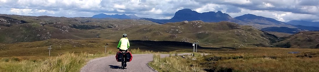
We disembarked at 11am and started walking up the forestry track north of the village. I was expecting it to be alive with fellow hikers, but those we had seen on the boat with backpacks seemed to be staying in the village. As we speed-walked up the track into pine forest, I looked behind and realised we were alone.
There wasn’t a cloud in the sky as the track forked and descended into pine forest again. The gentle if giant hillside of Ladhar Bheinn rose above a clearing ahead of us. The trees brought a measure of coolness on a morning that was building into a scorcher, and the pines gave the landscape a North American feel.
We descended to a river junction in a pleasant wooded glade and crossed a river on stepping stones. After a short boggy section beside the river, the path swung left to touch a corner of woodland on the flanks of Ladhar Bheinn and we started the steep climb up to the mountain’s west ridge. The 1:25,000 Ordnance Survey (OS) map offered no clue that there was a trail up these steep contours; but by switching my OS app to the standard view that uses the open map, I could see there was a clear trail straight up it. I had pre-programmed this route before we set off and, sure enough, the path was obvious.

It was one o’clock and we stopped for our first lunch beside some boulders at 350m. We could just about see the island of Rum peeping out though a gap in the horizon, but the view was about to get much better. The gradient didn’t slacken when we reached Ladhar Bheinn’s west ridge at Coire na Diollaide and turned up it to our right. Behind us, we could now look back on a jigsaw of land and sea painted in every shade of blue and green: the forests, the valley, the grassy hillsides, the sea and the sky. Beyond the waters of Loch Nevis and the Sound of Sleat, we could see the mountainous horizons of the Skye and Rum Cuillin, and the curious plateau-like island of Eigg.
The summit was still a long time coming as we plodded up 300 vertical metres of grassy slopes. It was one of those peaks where you can’t see the top until you’re virtually upon it. Aside from the views across northwest Scotland’s jagged and intricate coastline, the climb had been fairly uninteresting — a long, easy plod, far from being one of Scotland’s finest mountains. What I didn’t appreciate was that we were climbing it the wrong way round. Apart from four people fording the river, we had seen no one since leaving Inverie until a lone hiker passed us in the other direction just below the summit. Everyone else was coming up the other side.
We reached the 1,010m west summit first. There was an OS trig point there, but it was 10m lower than the main summit. We could now look north across Loch Hourn to the western summits of the south Glen Shiel ridge. A slender grassy ridge led the way to the main summit. We were between the two peaks when a single hiker stopped and offered to share a photo he had taken of the pair of us silhouetted on the west summit point, with Skye and the sea behind us. Edita gave him her Instagram handle and he typed it into his phone.
‘I see you’re from Lithuania,’ he said.

We moved on, which meant we didn’t hear him a few minutes later, when he read her Instagram bio on the west summit and loudly exclaimed: ‘Bloody hell, I’ve just been talking to the first Lithuanian woman to climb Mount Everest.’
We were now on the main trail. On the 1,020m true summit a man in a pink shirt and a Panama hat was leaning against the summit cairn eating his lunch.
‘I thought this would be a nice place to sit down, but I’m being guzzled by midges,’ he said. ‘I’ve never seen midges on a summit before.’
He spoke with a refined English accent and his enthusiasm reminded me of the writer and broadcaster Nicholas Crane. We couldn’t take our summit photos until he had gone, so we waited patiently as he told us about his walk up from Loch Hourn, and how there was a man with a boat waiting for him down in Barrisdale to take him back across the loch. Far below on the opposite shore, we could see two clusters of houses marking the remote villages of Arnisdale and Corran. Unlike Inverie, which is completely cut off, these two villages can be accessed via a tiny winding road that crosses the mountains from Shiel Bridge in Glen Shiel.
I could now see that the summit route on the east side of Ladhar Bheinn — the main route up — was much more intricate than the one we’d ascended, a series of snaking, undulating ridges with many subsidiary summits.
‘Did you come all the way up that ridge?’ I asked him.

‘Yes, I bloody well did,’ he said. ‘All those bloody ridges. But I had to come up that way. Everybody says this is one of the best Scottish mountains. And now I’m going down that way there.’
He pointed to a subsidiary spur descending north from the westernmost point of the summit ridge. The spurred descended over a small hump before going back up and over a 960m Munro top called Stob a Choire Odair.
‘I’d better get on, as my man is waiting for me.’
He stomped off and we watched him as we ate our second lunch. We sat a few metres away from the summit cairn where there were fewer midges.
We left the summit at 3.30. It felt late to leave, but we passed many people coming up even later. We reached the eastern end of the summit ridge and found ourselves facing a steep drop down the ridge on a broad path.
Four backpackers with big packs were spaced out in a line and just about to reach the top. Their presence, with open air behind them, made the ridge appear dramatic. It looked like they were teetering on the edge, with a deep drop into Coire Dhorcaill far below. They said they had walked for two days from Glenfinnan where we had bagged two Munros the previous day. They intended to continue over the summit and descend to Inverie on the trail we had come up.

We were now on Ladhar Bheinn’s fiddly side and about to discover why it’s considered one of the finest Scottish mountains. The ridge snaked up and down and left and right before us. We descended to 770m, then climbed back up to 858m, then went down again to 730m, then back up to the 840m summit of Stob A Chearcaill. There were several sections of scrambling that we gently lowered ourselves down.
‘This ascent goes on and on,’ one man said to us after we had descended some distance.
The standard route from Ladhar Bheinn to the campsite at Barrisdale, where we intended to spend the night, descends to the Mam Barrisdale, a 450m pass that divides Knoydart’s northern coastline from the broad valley leading west to Inverie. We would be coming back up that way the following day to climb Luinne Bheinn, so I wanted to take a different route today. I had identified a possible route off Stob a Chearcaill via its northeast ridge. The ridge looked gentle for most of its length; it dropped down to Loch Hourn and a path that led into Barrisdale from the west.
The only doubt was the section leading off the summit, where the contours on the OS map clustered together like they were trying to squeeze through a narrow gap. This bit looked steep, and there was no path marked down this ridge on any of our maps.
‘There is usually a reason for this,’ Edita remarked as I pointed out the route.

Despite Edita’s doubts and my offer of taking the standard route, she was determined to give it a try. Another problem was water. Edita had run out and I only had a few mouthfuls left. By keeping to the ridge we guaranteed that we wouldn’t find running water until almost at the bottom, although there might be a few stagnant pools we could replenish from if we were desperate.
I peered over the edge of Stob a Chearcaill. The land dropped away like a cathedral spire, but I was relieved to see that it wasn’t sheer. There were some crags, but it looked like there might be a way down that mostly kept to grassy terraces. It was the sort of route that Karl our guide in the Cuillin would have happily descended the previous week. But Karl was a guide who carried a rope. With a climbing guide, there was unlikely to be any obstacle we couldn’t find a way past. But without a rope or climbing skills, there was a much larger chance of coming to a dead end and having to retrace our steps.
Edita went first, but when she reached the first section of scrambling she let me take over. I eased myself down a narrow, sloping ledge about six inches wide — what I believe is known in climbing parlance as a rake. I needed both hands, so I threw my trekking pole down in front of me. It came to rest on the bottom section of the ledge, impeding my progress. I had visions of one of those silent movie sketches where someone stood on the other sort of rake — the one you use for gardening — and the handle popped up to twang them in the face. Luckily there was no slapstick comedy. With a bit of nifty footwork I was able to ease the sticks out of the way without kicking them over a ledge and out of sight. I turned around to help Edita with her own sticks.

We continued. There were a couple of sections where I needed to sit down and lower myself. This wasn’t always easy with a large pack; it had a tendency to get caught on the rock behind me. In one place I had to remove the pack and let Edita lower it down behind me along with her own. I had to squeeze between a rock crevice carrying both packs.
Progress was slow, but eventually I found a larger grassy slope off to the left; we descended it until we were level with the place where the ridge eased off. We traversed to the right to regain the ridge, the difficult section now behind us.
It had been a painstaking descent. We looked back up the slope that we’d descended and saw a series of near vertical slabs that we had somehow managed to cross by means of grassy ledges in between. I would never have gone up such a slope and was happy that we’d somehow managed to get down it without mishap.
We were surprised to see a clear path leading down the ridge. Clearly a few people must have been this way, but why? And where did they go once they reached the slabs?

We didn’t give it any more thought. My attention returned to replenishing our water. We could now see the homely pasture of Barrisdale Bay and the bothy far below us. We weren’t exactly going to die of thirst, but the heat was still intense and the thought of fragrant water sliding my throat put me in dreamland.
About halfway down the descent to Loch Hourn, the temptation to oil my gullet became too great. There were a few stagnant pools, but they were tiny and did not look very nourishing. Sipping from these would be like drinking engine oil. Eventually we passed a slightly larger one and my self-control withered like a dying rose. But when I kneeled down to refill and a few insects floating on the surface drifted into my bottle, I changed my mind. I was thirsty, but not so hungry I would eat anything. Perhaps I could wait until we found a bubbling stream. Instead, we stopped for a snack and I sucked an apple for its juice.
The ridge continued to descend at a steady rate until we joined the path west of Barrisdale. It was joyous to be back on firmer ground and even more joyous when we followed it down and heard the roar of a stream. We dropped our packs and diverted from the path to fill our bottles. We had chlorine tablets to purify the water, which meant we had to wait half an hour before drinking. But the stream looked clean and pure and I couldn’t resist a couple of mouthfuls first to slake my thirst.

We descended to sea level beside Barrisdale Bay and followed a gravel track to the bothy. We arrived at 8pm after nine hours of walking. The bothy at Barrisdale is unusual in that it is privately owned and run by the Barrisdale Estate. Most bothies in Scotland are owned by the Mountain Bothies Association, a charity that looks after them and allows them to be used by the public free of charge. Outside Barrisdale bothy there is a pleasant grassy area that is used as a campsite. There is no shower block, but the bothy has a proper toilet and a kitchen sink with running water, something you won’t find in most bothies. There is an honesty box inside the front door with a sign politely requesting a contribution of £5 for a night’s stay and use of the facilities.
There were five or six tents pitched in the campsite when we arrived and a few groups sitting around the bridge cooking with stoves. Some wore nets over the heads, not because they were beekeepers but because it was the midging hour and a few pesky insects were also enjoying their evening meals.
After our experience at Camasunary to previous week, where the bothy had been packed to the rafters, we were pleasantly surprised to find that the bothy here at Barrisdale had few residents with most visitors choosing to camp. There were only three other people staying there. The bothy had two dormitory rooms each with six bunks, so Edita and I ended up with a private room to ourselves.
We sat in the kitchen area with the other three residents. There was a pair of ultra runners who were doing long days on the Cape Wrath Trail. One of them spoke with a growl, rather like the comedian Johnny Vegas. The other resident was a single hiker who had just climbed Ladhar Beinn via a ridge that he said was classed as a grade 2 scramble. After a brief discussion we realised that he was describing the same one that Edita and I had descended.

‘Blimey, I would never have come down that way had I known,’ I said. ‘I don’t know about grade 2 scramble though. It was more of a grade 2 bum slide for us.’
We were all eating freeze-dried expedition meals and we discussed their merits. None of us were fans of the taste, but they are convenient for backpacking. My porcini mushroom risotto was recommended by the lady at Nevisports in Fort William, but I found it a bit too fancy. I finished it, but it was stodgy and a struggle towards the end.
We retired to our private room at 9.30pm. We heard voices in the kitchen until late. I nodded off, expecting some bothy latecomers to burst into our room. But they must have been campers who had come into the bothy to escape the midges outside. We slept peacefully and undisturbed.
Fearful of my previous Knoydart experience, when the eight hours of November daylight hadn’t been nearly enough to complete a laden hike over Luinne Bheinn and Meall Buidhe, I had persuaded Edita to make an early start the following day. There was a lot more daylight in May and our packs were much lighter, but we had a 6.30pm ferry to catch from Inverie and I didn’t want to take any chances.

Edita and I awoke together at 5.55am, just before my alarm was due to start beeping for an early start. We sat up and began silently packing. There was already someone in the kitchen area wearing a head net. It was a camper who had decided to come and have his breakfast in the bothy.
‘There must be a few midges outside?’ I whispered.
‘There are so many midges, I can’t believe it,’ he said. ‘There’s a whole army of ‘em.’
We ate our breakfast in silence, wary of waking up our fellow residents. But soon three or four more campers entered, all wearing head nets and talking at the top of their voices. We finished our packing and smeared midge repellent over our faces before stepping out of the bothy a few minutes before 7am. I expected a barrage of biting, but the midges weren’t that bad at all. We barely noticed them as we headed off on our second day.
Surprisingly after the previous day’s swelterer (yes, it’s a word) the sky was overcast. We couldn’t even see our first peak Luinne Bheinn, which was obscured by clouds. The weather forecast was for another blisteringly sunny day, so this came as a shock.
It was an easy start to the day. A comfortable trail climbed gradually up to the pass at the Mam Barrisdale and the temperature was pleasant. It occurred to me halfway up to the pass that we might be underneath a cloud inversion — that the cloud carpet above us was thin; we would climb into it and out the other side into scorching sunshine. This has happened to us a few times on Scottish peaks.

We entered the mists at 400m and visibility dropped to the length of a javelin toss. As we approached the past we found ourselves in boggy moorland, featureless but for the path we were following. Somewhere around here on my previous visit I strode off up a shoulder towards the summit of Luinne Bheinn. But there had been no trail and it was hard work carrying a heavy pack over rough terrain in snow. Ultimately it had defeated me.
Today there was no shoulder to stride off towards, so we continued on the path until we reached the top of the pass at 450m where there was a stunted cairn. There was no trail marked up Luinne Bheinn on either the OS or the open map, but at the pass we found a narrow, indistinct trail weaving off to the left. It wasn’t easy to follow in the mist and we couldn’t see where it ultimately led, but it was all we had, so I followed it more in hope than faith, and with a certain amount of distrust.
We had barely risen 50m from the pass when the mists started to thin; we saw a sliver of blue and the silhouette of mountainside above us. I had been right about the cloud inversion. This band of cloud was little more than 100m thick.
We could now see where we were going, but where was that? This trail was only marginally better than no trail at all. It was very boggy, and more strangely, it angled slowly up Luinne Bheinn’s west face rather than heading up to the firmer ground of the shoulder. This meant that our progress tended more towards the horizontal than the vertical we were aiming for. For a long time I wondered when we were going to start doing some serious ascent.

Eventually the path contoured across a small plateau and petered out altogether. We were still some 300m beneath the summit and had to forge our own way up steep grassy slopes. The trail hadn’t helped us much and it might have been easier to go off piste from the start.
To our west the clouds were slowly starting to disperse. Every so often I paused for breath and looked behind me down a broad valley towards Inverie and the sea. Ladhar Bheinn lay hidden behind the right-hand wall of the valley, but to our left was the crumpled hump of Meall Buidhe, our final Munro (hopefully) and the one that I had failed to reach on my previous visit.
We ended our slog up steep grassland when we emerged onto the summit ridge a few metres short of the summit. We stumbled upon a path and I looked down it to see that it had been following the ridge for some distance. There are many paths like this on Scottish hills that seem to start halfway up. It’s an enduring mystery to me why these trails don’t start at the bottom and you have to stagger up trackless terrain to find them.
But no matter. We were nearly at the summit and we were floating above a sea of cloud. Peaks rose above the cloud like islands. I could see that it must still be overcast down in Barrisdale, but down towards Inverie and the west coast things looked clearer.

We reached the top at 9.30. Luinne Bheinn has three summits of almost identical height. According to the OS map, the middle one is 1m higher at 939m. When I arrived there 16 years ago, I was on the verge of exhaustion and dangerously hypothermic. I couldn’t remember how I’d got down to Bealach a Coire Odair, below us to the south, so we decided to sit down for a snack and discuss our options.
A gully led down between the central and east summits, but there didn’t appear to be much of a path. As we ate our first sandwich of the day, Edita noticed that the land beneath the east summit tapered into a shoulder that led down to an obvious ridge. This ridge appeared to offer easy access to our next peak, Meall Coire na Gaoithe’n Ear — a name which made my tongue ache just reading it on a map (I decided to call it ‘Gimme an Ear’). Angling down to this shoulder looked like an easier descent than the gully, so we agree to take it.
Our route was steep in places with a couple of short boulder fields to cross. I learned later that the correct route went across Luinne Bheinn’s east top, but it was a piece of cake compared to the previous day’s grade 2 scramble. There was a minor hiccup when I slipped in a boggy section and wet the seat of my pants, but the day was becoming a scorcher again and my cheeks were dry in no time.
We descended down into Coire Odhar at 710m where there was a small tarn and a rocky outcrop that looked familiar. I believe it was the rock I leaned against, exhausted and shivering, 16 years ago and realised that I was becoming hypothermic. My intention that day had been to climb the next Munro, Meall Buidhe, and descend to Inverie. But I was running out of daylight and I realised that I had to descend as soon as possible. I evacuated down a narrow streambed, the Allt a Choire Odhair. It was steep and treacherous, with several small cascades. My pack was twice the size as the one I carried today, with five days’ supply of food. I had to take great care lowering myself beside the waterfalls, but I made it down safely.

Today it was a different kettle of fish. We had much smaller packs and the sun was shining brightly. In 2007 I was racing the darkness to reach Inverie by 4pm. We had a deadline today too, our boat to Mallaig at 6.30pm, but it was only 10.30. We were feeling strong and we still had plenty of time.
The remainder of the climb up to Meall Buidhe was a joy. We followed an easy path up a gentle grassy ridge laden with rocky outcrops. Gimme an Ear turned out to be a pleasant plateau with long views in every direction: the three Knoydart Munros were west, northwest and north; the pointed pyramid of Sgurr na Ciche was to the southeast; and the Glenfinnan Two that we had climbed the previous day were to the south.
We skirted the summit of another peak, Druim Leac a’Shith (which sounds like the end product after a particular spicy haggis), and joined an undulating ridge to the base of Meall Buidhe. We stopped for a snack before the final ascent to our last Munro, and sat with our legs to the south, where Sgurr na Ciche rose Matterhorn-like above the few remaining wisps of cloud.
The climb up onto the summit of Meall Buidhe was fun. It didn’t quite qualify as a scramble, but there were some steeper sections that were a bit more than a walk. Meall Buidhe is a broad grassy ridge with two summits about 300m apart. The second one was the 946m true summit. Clouds were bubbling up from the south, looking like they would overcome the peak at any moment. We raced across the divide and arrived there at the same time as two more parties of hikers, the first people we had seen all day.

The clouds remained south of the ridge so we leaned our packs against rocks and relaxed in soft grass on the north side of the summit, looking across at the Mam Barrisdale and Ladhar Bheinn. Meall Buidhe was my 150th Munro and Edita’s 80th. It was a satisfying moment after my experience in these hills sixteen years earlier. It had felt like unfinished business. We were racing against the clock again, but it was still only 12.15 and this time I knew that we would make it. It had taken us just over five hours to cross complex ground over two Munros. We still had six hours to descend to Inverie. We could even have a pint in the Old Forge, the remotest pub in Britain — assuming it was open. What a marvellous way to finish that would be!
We stayed on top, eating our lunch and soaking up the view, for about half an hour. The descent to Inverie was straightforward, except for one section. A broad and gently declining ridge ran due west from the summit of Meall Buidhe. It went over one further summit, 826m An t-Uiriollach (or ‘Ant and Dec Urinate’) before descending through thick grass to an altitude of around 200m. There was even a faint trace of a path all the way.
The final 100m of descent was trickier. We were aiming to descend to the south of the ridge to join a trail back to Inverie at a bridge that we needed to cross. But that part of the hillside was barred by steep crags and scrubby bushland. Keen to avoid a repeat of the previous day’s grade 2 bum slide, we descended the western side instead, which was steep but grassier.
By the time we reached the valley floor, we were some distance past the bridge that we needed to cross. Rather than doubling back on ourselves, we found a place where we could cross the river on boulders. For the second day in a row we were parched with thirst and running out of water. I refilled our bottles while Edita bathed her feet in the fresh stream.

The remaining 5.5km were boring but easy. The terrain was flat and the ground was firm. We were soon in the same broad valley we had looked down from the ascent of Luinne Bheinn. After crossing the Inverie River on another footbridge, we reached a 4WD track which we followed all the way back to the village. The road climbed high above the village before descending into it through forest. The final section, along a tree-lined avenue beside the sea, had a tropical feel to it on a day like today.
We arrived at the Old Forge, a short walk from the pier, at 4pm. The pub has the most pleasant beer garden you’ll find anywhere in the world, across the road on a patch of grass above a pebbled beach. The beach looked out across the sheltered bay of Loch Nevis as its waters shimmered in the afternoon sun. On the opposite side of the loch, a gateway between the mountains provided a glimpse of the sea and islands beyond. It was through that gateway that our boat would come.
We still had two hours to kill before our ferry. There was only one thing to do. I walked into the pub and my heart sank as I heard the sound of a drill. The pub has recently been bought by the Inverie community after a long period of private ownership. The building was undergoing renovation. However, a sign on the door invited me to visit the shop next door to buy a bottle of Knoydart Brewery ale. It was an invitation that I eagerly accepted.
We sat at a wooden table beside a pebble-dashed beach looking out at the view before us and looking back on a fabulous couple of days. As more people arrived for the ferry and lay on the grass, a festival atmosphere developed. It was a great way to end our trip. My long mission to climb the Knoydart Three had ended in the best possible way after two days about as perfect as they come.
You can see all the photos from our week in my Glenfinnan and Knoydart Flickr album.
Day one: Inverie to Barrisdale via Ladhar Bheinn
Total distance: 17.78km. Total ascent/descent: 1,332m.
View route map and download GPX
Day two: Barrisdale to Inverie via Luinne Bheinn and Meall Buidhe
Total distance: 20.57km. Total ascent/descent: 1,536m.
View route map and download GPX


Wonderful recounting and illustration of your expedition to Knoydart. Enthralling, as usual.
Nice trip – and you were lucky with the weather.
Seems you missed out on Coire Dorcaill – the magnificent northern corrie of Ladhar Bheinn.
A pity – it falls from the very impressive crags – good in winter! – to the shore itself – and is actually owned by the John Muir Trust. It was their first acquisition in the early 70s when the MoD were considering purchasing the Knoydart peninsula as a military training area, believe it or not.
Indeed, the JMT is an outfit that’ you should do a piece about – indeed join. A very worthy and worthwhile organisation on the right wavelength.
Thanks for posting, John. Nice to know you are still reading my blog 🙂
I did have a quick look at Stob Dhorrcail as a possible descent route and decided it looked too steep. If it’s a climbing venue then I guess it was a wise decision. Stob a Chearcail was enough for us!
Actually I’ve been a JMT member for a few years now. The week before our Knoydart trip we were on Bla Bheinn, much of which is also owned by JMT and where a lot of new woodland has been planted. A very worthwhile organisation indeed.
Just stumbled across this and very pleased I did. Glad to read about this amazing part of Scotland. Your tale makes me want to go back. Thanks and keep up the great work.