
This is the first in a series of posts about my recent visit to Ladakh in northern India, my first foreign holiday after the COVID-19 pandemic.
Little did I know when my flight from Colombia touched down at London Heathrow Airport on 2 January 2020, that I wouldn’t be leaving on another foreign holiday for more than two and half years.
I didn’t really miss it at first. 2020 was our first year in the Cotswolds and being locked down in such a magical place for the pandemic wasn’t exactly a hardship. In 2021 we made no fewer than three trips to Scotland and they were some of my most enjoyable Scottish holidays.
But nothing quite matches a remote trek in the Himalayas and I’ve had to wait even longer to return on one of those. I have to go all the way back to Spring 2018 when Edita and I did the Kangchenjunga Base Camps trek. On that occasion our only peak was 5,958m Drohmo Ri, an easy walk up.
I’m probably not alone in admitting that I’ve emerged from these strange times a changed person. We’ve all had a bit of time to reassess our lives, and while some have quickly readopted their old ways, many of us have different priorities now.
I had to ask myself the question, how would I respond to a multi-day remote camping trek after such a long time? I used to love it, but it’s not everybody’s cup of tea. Would it still be mine? Would I still be able to retain my balance while squatting over a long-drop toilet, for example?
My favourite treks of all were those that included a big 6,000m peak. But my ice axe and crampons have been gathering cobwebs for nearly three years and I’ve had a lot more practice swinging a wood-cutting axe recently. Were my modest climbing skills going to be up to it?
It was largely, though not entirely, for the latter reason that we chose to go to Ladakh in northwest India this time around, rather than Nepal. Ladakh lies north of the Himalayan divide in a desert-like landscape more akin to Tibet than the forested mountains of Nepal. The snowline sits higher in these parts and Ladakh contains a profusion of 6,000m peaks that technical climbers might describe as easy walk-ups.

It was 15 years since my last visit to Ladakh and a return was long overdue. Edita had never been there at all. Also, our go-to man for our last couple of Himalayan trips, Jamie McGuinness of Project Himalaya, runs trips to Ladakh using a different local operator Zanskar Trek.
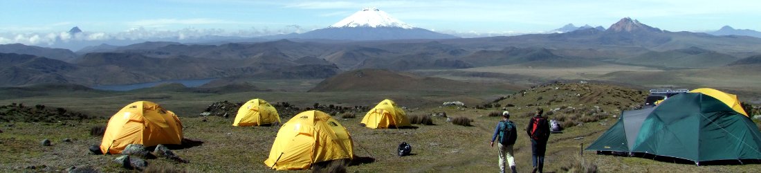
While a great many trekking operators provide good staff and logistics, himself included, Jamie excels in finding suitable trekking peaks. We discussed a few different options with him, including some more exploratory peaks. In the end, as this was our first trip for a while and we needed to get back into the groove, we chose the better known and more popular Markha Valley trek. For our peak, we chose a mountain at its upper end, Dzo Jongo, with two contrasting summits, East and West (6,220m and 6,280m respectively) which sounded reasonably straightforward.
We were all set to go when, at the last minute, Jamie announced a change of plan. Apparently the highest mountain in the area, Kang Yatze (6,496m), was in good condition and 300m of rope had been fixed on its upper sections. Jamie would get us a permit for that instead of Dzo Jongo. His instruction to bring our jumars with us could have set alarm bells ringing, but I trusted him. He knows what he’s talking about, I thought. Presumably Kang Yatze would be just as easy to climb as Dzo Jongo, only a little bit higher.
Unlike the rest of India, which is predominantly Hindu, Ladakh is a Buddhist region. It is sometimes known as Little Tibet, and is reputed to be more like the old Tibet than Tibet is now (though the massive Indian Army presence in the region and profusion of hotels, restaurants and souvenir shops in Leh somewhat belie this). The landscape is dominated by monasteries. Stupas, prayer flags and mani walls provide a flavour of mountainous Nepal rather than the rest of India.

Ladakh’s capital Leh feels like a more relaxing version of Thamel, Kathmandu’s tourist heart. It lies at an airy altitude of 3,500m, so we spent a couple of days acclimatising there before our trek. Regular readers may be thinking that by acclimatising I mean hydrating, but unlike Kathmandu, where it was once possible to buy beer in a bookshop (until the bookshop in question burned down), many restaurants in Leh don’t serve alcohol at all, and you have to know where to look.
Despite the altitude, the sun provided searing heat during the day and it was pleasantly warm in the evenings. We drank plenty of water. We made an acclimatisation hike up to Shanti Stupa on a hillside above town, and did a monastery tour to Thiksey and Hemis monasteries further afield. At the museum in Hemis we saw the mountain bike that the 12th Gyalwang Drukpa had used to cycle from Kathmandu to Leh while being accompanied by 250 kung fu nuns. Very wholesome and inspirational (as in, I was inspired to buy his book, not go mountain biking, which I’ve tried with mixed results).
Another thing Ladakh has is very good roads, smooth as a polished snail shell, and weaving up, over and around quite excitable terrain. Jovial signs are positioned at regular intervals encouraging drivers to slow down with messages such as be gentle on my curves and road is hilly, don’t drive silly. These signs were about as effective as a cardboard teapot. Our driver hurtled along like a lunatic. The only man who could have been less gentle on curves was Matt Hancock. I chanted ‘om mani padme hum’ in the back seat and regretted not buying a prayer wheel in Leh.
We followed the wide Indus Valley until its junction with the narrower Zanskar, which wound from left to right between towering cliffs. The road remained tarmacked, allowing our driver to keep his foot glued to the accelerator pedal. We turned off again, this time up the Markha Valley. The road became a dirt track and I breathed a sigh of relief. We reached the start of our trek at the village of Skiu without plunging off a hairpin into a gorge.

At Skiu we joined up with the rest of our crew. We had met our guide Santosh in Leh and he had travelled with us. I had been impressed with his haircut, which sprouted from the crown of his head like pampas grass, and by the voltage he must have been able to resist to make it stand up like that. Santosh was a regular climbing guide with the big UK adventure travel company Exodus. He was from Darjeeling, where he had studied at the Himalayan Mountaineering Institute (HMI), the climbing school set up and led by Tenzing Norgay after his first ascent of Everest in 1953.
Now we met our cook Tukten, a Nepali from the Makalu region, who turned out to be one of the most creative cooks I’ve ever trekked with, and our assistant guide Imran.
‘What, as in Imran Khan?’ I said when I was introduced to him.
Imran was a Tibetan Muslim whose grandparents had fled from Tibet to Darjeeling in 1959, at the same time as the Dalai Lama. I didn’t even realise there was such a thing as a Tibetan Muslim, but Imran explained that there had been quite a community of Muslims in Tibet, many of whom also left Tibet after the Chinese occupation. Like his namesake, Imran proved to be a great all-rounder. Not only could he bat and bowl, but he could cook, climb and drive horses.
We met the final member of our crew, our horseman and his eight horses in the village of Sara after the first day’s trek. You may be wondering why we needed eight horses when, besides Edita and myself, we had only a guide, an assistant guide, a cook and a horseman. But apparently in Ladakh it’s not possible to hire only three or four horses. If you hire a horseman, you’ve basically got to take all his horses, regardless of whether they’re any good at carrying. Our first horseman (whose name was Tenzing, ironically given that he was the only one of us who wouldn’t be climbing) even brought a donkey with him. Donkeys can only carry about 60kg, compared with the 80-90kg that a horse can carry. This one also had the annoying habit of braying outside our tent in the small hours of the morning. But we had hired Tenzing, so the donkey had to come too.
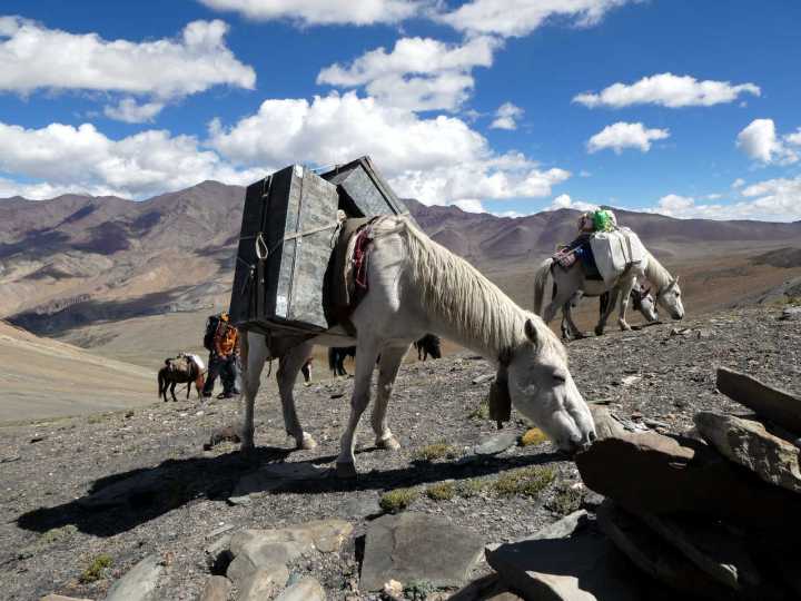
For the second part of our trek, Tenzing was replaced by a different horseman Nawang (who inevitably became known as Nawang Gombu). Nawang’s horses included a mother with a foal, so the foal followed behind us all the way, carrying absolutely nothing, not even a small daypack.
Over the years, the Markha Valley has become arguably Ladakh’s best known and most popular trek. Part of the reason for this is its accessibility – just a short journey from Leh, even before the road was polished with tarmac. Another reason is its length. It’s now only a three-day walk from the end of the road to Hankar, where the Markha River forks into two smaller rivers. The steeper of these, the Nimaling Chu, rises to a high pass, the 5,216m Kongmaru La. On the other side of the pass it’s a short descent back to the Indus Valley, from where you can pick up a road back to Leh. The Markha Valley can thus be trekked in less than a week. Indeed, we met people who were doing it in only four to five days.
But another more deserving reason for the Markha Valley’s popularity is its scenery. The valley is steep-sided for its entire length. Red cliffs tower over the river on both sides, frequently crowned with impossibly crinkled pinnacles. For much of its length the valley is up to half a mile wide, but in places it narrows to what can reasonably be described as a gorge. The valley has been inhabited and cultivated for a very long time. The river is curtained by a band of green all the way along, comprising giant poplars, smaller willows and seas of wheat. These shaded groves have been protected from animals by seabuckthorn, a most useful plant with medicinal properties whose berries not only provide tasty juice, but whose prickly branches can be made into impenetrable hedges when piled along the ground and left to dry.
People have lived here for centuries. Ancient stupas and mani walls can be seen at regular intervals. Monasteries perch on hilltops and there are many ruins from times past. If you look up, you can often see caves that were once inhabited, peering like faces out of cliffs.

The downside of all this civilisation is that there is now a road for most of the valley’s length. While we never saw any traffic except the four-legged variety, walking along a dirt track doesn’t have quite the same allure as a narrow trail along a hillside. There were places where a trail diverted from the road for a short period, but these were the exception rather than the norm.
The first day involved a short walk of only three and half hours from Skiu to the next village, Sara. We followed the road for almost the entire way, walking in searing afternoon heat and grateful for the short interludes when the road tickled the poplar groves and their shade provided some respite.
About 45 minutes short of Sara we found ourselves passing through a lush, grassy water meadow and spied a large white dome tent up ahead. We thought we had reached our campsite and were disappointed to discover that it was what passed for a teahouse in those parts. An enterprising villager had set up shop in the middle of nowhere, but the surroundings were pleasant and we stopped for a bottle of Mountain Dew.
Our campsite in Sara was set within a more extensive plantation and was pleasantly cool. The altitude gain had been gradual. We had barely felt like we were rising at all. In fact, Sara was at 3,540m, which meant we were still no higher than we had been in Leh.

But we were far more remote. This was brought home to me as I returned to my tent after dinner and I glanced up at the sky. I’ve never been much of a stargazer; this might be explained by the fact that I’ve lived most of my life in London, where light pollution means that stars are barely visible. I’ve been looking at the sky more often since moving to the Cotswolds three years ago. But the sky above the Markha Valley that night was something else. The stars shone brightly like bulbs, and I could even see the milky sheen of a billion dimmer stars in the further reaches of the universe. It was a ‘wow’ moment when life’s little troubles fall into perspective and you’re left contemplating what a wonderful, startling place we inhabit.
The second day passed in much the same vein as the first as we continued along the road to the village of Markha, rising only 250m to 3,750m. Sometimes the poplar and willow groves petered out into scrubby grassland and we passed through a landscape reminiscent of the wild west — the sort of place where you might expect to see Clint Eastwood crouching behind a bush, aiming a rifle in your direction.
Edita made two new friends that day. The first was the owner of another tented teahouse. She was spinning wool into a yarn on a tiny spindle that she pressed against the ground, and knitting socks with the thread that she produced. She let Edita have a go – luckily not for long enough to knit the Lithuanian flag into the side.
Our campsite in Markha village was in another delightful grove of trees beside a wheat field. Our tent was pitched in the shade of a sprawling willow. Edita was invited into the home of Dolma, the only schoolteacher in a village of 150 people. Dolma told us that her husband taught at a school in the Nubra Valley the other side of Leh. Each taught for 10 months of the year in their respective villages and met up in Leh during the coldest months of January and December, when it was too wintery to remain in the village.

She also told us how the school had been washed away by a flood a few years ago. We passed by its ruins the following morning, in an obvious flood plain right beside the river. The rest of the village was perched more safely on a hillside above. It was fortunate there were no classes when the river flooded; all that was lost was a building. Dolma said there are currently only five children attending the school and a tiny building higher up the trail suffices as a classroom. Edita peered into it as we passed. Three equally tiny kids were sitting on the floor. Dolma hadn’t arrived yet. so Edita asked them to say hi.
We passed another more elderly lady perching on a rock in a picturesque position overlooking fields. Edita asked if she could take her photo, and the lady readily acquiesced. Then she muttered something to Santosh and I was surprised to see him fish 500 rupees out of his backpack and hand it to her.
‘500 rupees for one tiny photo?’ I cried. ‘That’s ridiculous!’
But Santosh explained that the lady was collecting ‘donations’ for the local monastery. All trekking operators are obliged to pay them if they pass by with tourists. It reminded me of the ‘permit fees’ that Maoist guerillas used to ask trekkers to pay in Nepal during the height of the Maoist insurgency in the early 2000s — only in this case the penalty for not paying was probably reincarnation as a monkey.

We left the poplar groves behind that day as the vegetation dwindled. We also left the road behind and the scenery became more dramatic. The valley narrowed and the steep cliffs on either side became needle-like pinnacles thrusting extravagantly into the sky. We had our first view of Kang Yatze at the head of the valley, guarding the Markha River’s fork. A snow-capped cone, it was volcanic in appearance from that angle — an easy snow-plod, the like of which I’ve completed many times. Santosh explained that the snow slope we were looking at was Kang Yatze II (6,185m). It was joined to our summit Kang Yatze I (which we could just see peeping up behind) by a narrow ridge. We would be climbing from the other side where the terrain was very different.
It was another short day and we reached Hankar (3,950m), shortly after lunch. The village was located at a broad confluence of valleys. Our campsite was less enclosed than the previous two. It was surrounded on two sides by tiny willows, but none were tall enough to provide shade from the relentless sun. We were right in the middle of the junction and it felt quite open, despite the red rocky hillsides all around.
Luckily, at 4.30 the sun dropped abruptly behind a hillside and the whole camp fell into shade. Unluckily, there was a small wheat field next door to our campsite. Now that the sun had relented, the owner chose this moment to start harvesting his crops with an electric strimmer… and continued for the next three hours until it was pitch black. Luckily, I was reading the 12th Gyalwang Drukpa’s book that I had picked up in Hemis. The calming nature of the writing prevented me from wishing the farmer to chop his leg off in the darkness.

Until then, we had kept to the valley floor and our ascent had been so gentle that it hadn’t really felt like we were climbing. The following day things started to change.
We rounded a corner in a narrow part of the valley and the path turned away from the river to climb a steep gully. At the top was a flat area with some mani stones. Santosh pointed above us to a steep knoll around 200m high that we had passed behind. At the top were some impressive ruins which he said were the remains of the King of Hankar’s palace. On my Maps.me app it was marked as the Palace of Shey Kingdom. We put down our packs and walked up the knoll on a narrow path which clung precipitously to its side.
The ruins were amazing and occupied the whole ridge line at the top of the hill. Little remained of the various outbuildings apart from a few walls, but a tall tower on the needle-like summit of the hill was almost intact. Had this been the UK, someone would have set up a booth at the bottom of the hill and charged an entrance fee, but this was all free and we were the only people there.
To get up to the tower we had to scramble up a narrow path beside crumbling rock. We climbed onto a small summit marked by willow wands and looked back across at the tower. Santosh scrambled up to its lower floor and peered back through the window, but he became nervous when I tried to follow.

‘Not safe!’ he cried.
I got as far as a makeshift bridge composed of three wooden branches. This was the only means of passage beside the tower wall above a vertical drop. I decided that was enough.
Descending back to the trail, we skirted around a village overlooking a fertile crescent of wheat fields. On the left we saw our first blue sheep of the trip, grazing among an apparently barren dip in the hillside.
The next section of path was pleasantly picturesque, skirting high above the fields with Kang Yatze up ahead. Not long after this we reached the confluence where the Markha Valley officially came to an end. Geographically, however, the river continued to the right, changing its name to the Langtang Chu. We would be rejoining it later in the trek and continuing up it.
Now we took the left fork, turning up the slightly steeper valley of the Nimaling Chu. Red rocky towers formed the backdrop, but the trail stayed to the boulder-strewn river bed. We had several small river crossings as we zigzagged back and forth. Mostly there were stepping stones, but the current was fierce and we had to take our shoes and socks off and dip our legs in for the final bit.

The trail then rose steeply to reach the outskirts of Tachungtse village (4,250m). We were above the treeline now, but the village was still a grassy oasis among an otherwise rocky valley. Our crew had pitched our camp on the very bottom terrace of the village. It was a nice spot and had a more wilderness feel compared to the villages of the Markha Valley.
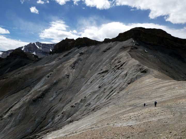
It had been a short day but the next one to Nimaling was going to be more vigorous, in ways that I could not imagine. It was only a 600m climb, but it started steeply. We had only climbed a short way when I discovered that I was already out of breath and struggling to keep up with Edita and Santosh. It was the first time I’d been to that altitude in nearly three years, and I had forgotten to do the slow plod. I realised that I was climbing much too quickly.
But the slow plod didn’t help. The trail curved to the right then back to the left to reach a promontory with cairns. I arrived there gasping for breath and it took a few minutes for my breathing to return to normal. I couldn’t remember being so breathless at high altitude. What was wrong with me?
Thankfully, a short distance above this we crested a rise and the terrain flattened out. A shelter wall had been erected beside an ash grey lake. Kang Yatze rose up beyond it and we had our first opportunity to see the route we would be climbing. Or perhaps not. I didn’t like what I saw at all. It looked steep, 45% or more almost all the way up with many hanging seracs and some vertical sections. Santosh described the route and said we would need two glacier camps. There appeared to be some objective danger between them, involving a traverse beneath a cliff with hanging seracs that clearly sheared off from time to time. Alcohol isn’t easy to find in Leh, but if this was Jamie’s idea of an easy trekking peak then I’d have to find out where he drinks. Far from being an unchallenging return to the mountains, this was going to be a serious mountaineering challenge. It made Kwasi Kwarteng’s budget seem like a sensible idea.

We had lunch in the shelter with a young Israeli couple who were trekking in a very different style to ourselves. They were carrying tiny day packs, and when I asked him how many horses they had hired to carry the rest of their equipment, he didn’t understand my question. This was all they had. They had started from Sara three days ago, and tomorrow they would trek over the Konmaru La and get a taxi back to Leh from the bottom of the trail. They were sleeping in homestays and buying food from villagers as they went along. Which was fine, they said, apart from the time they were offered a raw potato. My sleeping bag alone was bigger than their packs.
Meanwhile, I was having my own difficulties with food. When I stood up to leave after lunch, I felt bloated. I was unable to fasten the waistband on my backpack and had to loosen it. I thought about finding a large rock to hide behind to relieve my bowels, but it felt like I wouldn’t be able to.
It was Edita who diagnosed my ailment.
‘Have you been for a pee today?’ she said as I trudged slowly onwards. ‘You might be suffering from water retention.’
She was right. In the intense heat before lunch I had been drinking water profusely to prevent dehydration at high altitude, but at no point had I needed to sprinkle the gentians, so to speak.
‘I was feeling a bit like that yesterday, but I feel fine now,’ she said. ‘Hopefully you should be better by tomorrow. If not, then I can give you some Diamox. It’s a diuretic. It should help.’

Edita had kept her health problems low key, but here I was struggling like a constipated tortoise. This sudden revelation about water retention brought to mind another story that I had been thinking about recently. Before coming to India, I had been in contact with one of my trek leaders from my last visit to Ladakh in 2007. I’m not going to mention her name in case she doesn’t appreciate it coming up when someone googles the phrase ‘makeshift catheter’. She’d become something of a legend in trekking circles after saving the life of a client who had also been experiencing prolonged water retention. After days of suffering, she improvised a medical procedure using a Bic biro and he started peeing again.
I told this story to Santosh as we walked to Nimaling, finishing it with a violent upward shoving motion.
‘I know you have a first aid qualification. Would you be willing to carry out this procedure if it’s needed,’ I asked.
He grimaced. ‘I give you Diamox,’ he said.
Luckily Edita managed to get my water works flowing again later that evening by means of a stomach massage.
The afternoon walk to Nimaling was more gentle than the morning’s climb, and we reached our campsite early in the afternoon. Nimaling was not at all like I’d expected. I had somehow pictured a village perched on a hillside. It turned out to be a large tented camp in a wide, flat valley surrounded by rolling hillsides that contrasted strongly with the jagged red rocks that hemmed us in on previous days. It was a grassy sanctuary with a powerful river, the Nimaling Chu, running through it.

We had now climbed to 4,820m and we spent the next two days in Nimaling acclimatising. I got very little sleep the first night, for various reasons. Altitude wasn’t one of them. Having opened the flood gates, I found myself filling my 1½-litre pee bottle early in the night. A couple of hours later I needed to go again. With a full bottle, I had to put my clothes on and go outside the tent. Then it started raining and I was unable to sleep as the drops pattered loudly on the tent. By morning we were surprised to discover that it wasn’t rain but snow.
But the main thing keeping me awake was the decidedly hairy mountain we now had ahead of us. By morning I’d made up my mind that I had no intention of climbing it. When I suggested to Edita that we revert to our plan of climbing Dzo Jongo West, she immediately agreed.
Despite dispatching us on a two-day ordeal up a horrendous wall of hanging seracs, Jamie had taken a sensible precaution. He had chosen our staff well and had warned Santosh that he was sending him a pair of demanding clients with a habit of changing their itinerary halfway through a trip.
I decided there was no point delaying things. I would broach a potential change of plan at the first opportunity.
‘Can we climb Dzo Jongo West instead of Kang Yatze?’ I said as Santosh slid down the zip of our tent at 7am to deliver bed tea.

He paused for a quarter of a second.
‘Yes, I think Dzo Jongo is better.’
‘Actually, can we climb both Dzo Jongos?’
‘Yes, no problem.’
And that was that. For us, at any rate. Santosh still had the issue of getting permits for a different mountain, but he said we could buy one from a man here in Nimaling, and he didn’t same to be fazed by the prospect.
With clouds hanging over camp for most of the day, Edita and I did a small acclimatisation hike up to 5,000m on the trail to Kang Yatze base camp. When we looked back, the clouds cleared briefly, enough for us to see the Konmaru La on the opposite side of the valley. This was the way back to Leh and the Indus Valley. The pass itself was only a shallow dip in an otherwise continuous ridge. We decided that the following day we could explore the ridge and maybe reach one of the summits along it.
It was cloudy again the next day, though it hadn’t snowed overnight. At around 10am we set off for the Konmaru La. I plodded at an easy pace without stopping. There was a single zigzag above camp and then a direct line almost all the way to the pass. The ascent was gentle and we reached the 5,216m top after only two hours. There were several prayer flags and we sat down for some tea, but we were now in cloud and a light snow began to fall.

A wide stony ridge led off to the north of the pass. Keen for further acclimatisation, we set off along it. We crossed some indistinct summits and the sky gradually cleared. Each time we reached a summit, we agreed to continue to the next one.
‘If we keep going like this we’ll eventually reach Stok Kangri,’ I said.
‘Yes, this is Stok Kangri ridge,’ Santosh replied, laughing.
Santosh led onwards. There seemed to be an unspoken agreement that we would continue to a big stone summit about a mile along the ridge, much taller than those surrounding it and marked by a large cliff face. There were some rocky pinnacles on the ridge line but we kept below them to the left, over soft scree. Santosh cut left of the cliff face and some easy terraces brought us out above it onto the summit. I took out my GPS and found we were at 5,480m. We were very happy. It would be great acclimatisation for us.
I asked Santosh the name of the peak.
‘No name,’ he replied.
‘Then I will call it Konmaru La Peak.’ Unimaginative, I know, but uncontroversial.

We were enshrouded in cloud again and snow was falling, so we didn’t stay for long. On the way down the mist cleared and Santosh found a rocky platform looking east towards the Indus Valley. We stopped for tea and a snack. Unlike the wide Nimaling valley where we came from, the far side of the Konmaru La was a panorama of jagged ridges.
Edita sat down next to what she was convinced was the stool of a snow leopard. For the next five minutes she spoke in whispers, certain the beast was nearby.
‘You’ve got no chance of seeing one,’ I said.
‘We might,’ she hissed, ‘it’s just been lying here right next to me.’
‘No, it hasn’t. It just had a shit and moved on.’
We had a rapid descent. Instead of returning along the ridge to the pass, Santosh took a direct traverse down the scree-laden hillside. By the time we rejoined the trail below the pass, the sky had cleared, the sun was bright and we had the best possible view of both Dzo Jongos and Kang Yatze.
It was like looking at a purring pussy cat crouched next to a roaring lion. We were closer to Kang Yatze than when we last saw it at our lunch stop on the way to Nimaling, and I could study the climbing route even more clearly. It was a mountain of two halves divided by a big, black, vertical face that screamed ‘certain death’. To the right of the face was Kang Yatze II. A long, featureless snow slope led to its top, which was hardly a summit, more a bump on a jagged ridge which ultimately led to Kang Yatze I. We had seen climbers on this snow slope below Kang Yatze II two days earlier. It was an achievable objective, but not very interesting.

To the left of the face was the route up Kang Yatze I, with its maze of vertical seracs. I had no regrets about our decision to abandon it. Easy trekking peak this was not, unless Mo Salah was going to turn out the following Sunday to play for the Keepers Arms in Northleach. It would be a serious mountaineering challenge with success uncertain.
By contrast, the two Dzo Jongos were perfect. A couple of snowy ridges, a bit of snow or glacier walking but with nothing very technical. You could clearly walk up to their respective high camps and enjoy a comfortable night there. The route up Dzo Jongo West was partially hidden by another peak, Mallari Ri, but summit day on Dzo Jongo East looked to be quite a nice ridge walk. I had no doubt that we would be able to climb both, even with less-than-perfect weather.
We got back down to camp at 3pm after an enjoyable acclimatisation hike. By walking up to the Konmaru La, we had pretty much completed the Markha Valley trek and enjoyed it immensely.
But our trip was far from over and it was time to tackle my first 6,000m peak in over three years.
Continued in part 2: Dzo Jongo East, a 6,000m peak so easy you can just walk up it.
You can see all photos from our Markha Valley trek in my Flickr album.


My first trek in 1992. No roads. Lots of river crossings in the Markha valley. Came back down part of the trail in 1996 from Martselang across Gongamaru La to Nimaling, but then cut SE across Zalung Karpo La and 2 more high passes. That was a lovely, much more remote trek.
Yes, indeed – you’ve pre-empted me! It still is remote. No villages on that section until Dat, a day and a half beyond the Zalung Karpo La. That bit is coming in a later post…
Nice article, Mark. Good to be back in the Greater Ranges (vicariously).
I’d like to know what your trips cost but you never say, as far as I know — presumably you decided long ago not to include budgets and menus and kit lists in your articles. You did discuss the macroeconomics of your mountaineering in “Seven Steps to Everest” I think.
I’m sure the Ladakh mountain air was wonderfully clean and the stars never so bright, but every star that we can see without a telescope is less than 5,000 light years away; the centre of our galaxy is about 25,000 ly away. Apparently our neighbouring galaxy, Andromeda (2,700,000 ly away), can be seen with the naked eye (probably as a dim dot) in very clear skies. Interestingly, Mark, Andromeda is going to collide with our galaxy in a few billion years.
Haha, yes indeed, how does the Monty Python song go?
“We’re 30,000 light years from galactic central point, we go round every two hundred million years… and pray that there’s intelligent life somewhere up in space, cos there’s bugger all down here on Earth!”
Thanks for the insights. Maybe Andromeda will be doing us a favour! 🙂
Hi Mark,
Thinking about doing this trek and came across your post. What is the name of the book you mentioned? Been trying to fing in but cant… 🙁
My Crazy Tale by His Holiness The Gyalwang Drukpa
Are the meal services at the camps still available late Sept/early Oct? I guess it may depend on the season..?
We took our own cook and supplies 🙂
Thanks I enjoyed reading all the posts on Ladakh and your climbs. Is it possible to share the contact details of your guide Santosh. Thanks in advance.
What a beautiful reflection on returning to the Himalayas after such a long break! The Markha Valley trek sounds like the perfect reintroduction—wild, remote, and full of that raw Ladakhi charm that makes trekking in this part of the world so special. I can really relate to the feeling of waiting for that next big mountain journey; the pandemic certainly made many of us pause and re-evaluate our connection to travel and nature.
Your mention of Kangchenjunga brought back memories of my own treks in eastern Nepal. That region still feels so untouched, and the combination of soaring peaks and rich culture always draws me back. If you’re ever looking for new Himalayan adventures, Nepal has so many hidden gems beyond the usual circuits!