
A couple of weeks ago I wrote about a 2-day backpacking trip in Knoydart that was about as good as it gets: perfect weather, unobstructed views of Scotland’s intricate coastline, three contrasting summits, some exhilarating scrambling, celebratory drinks at the remotest pub in Britain — even a picturesque boat trip at either end.
The trip was all the more satisfying for me because it was my second visit to Knoydart and I had unfinished business there. My first visit in 2007 couldn’t have been more different. I set off for 5 days of backpacking in winter. Everything that could go wrong did — except that I lived to tell the tale.
I didn’t start writing this blog until 2010 but I do still have my diary of that trip. I thought I would dig it out for a laugh, so here is an excerpt. My visit with Edita last May was so completely different that we could have been walking in a different world. The photos look pretty grim too.

Thursday 8 November, 2007 — Barrisdale, Knoydart, Scotland
The road drops steeply to the end of the sea loch at Kinloch Hourn and I’m thrilled to see red deer regularly by the roadside. I stop in at a car park area opposite a deserted farmhouse near the end of the road. The place is empty but there’s an honesty box on the doorstep to collect £1 per night for overnight parking. I drop four coins in and return to my car to gobble down one of my packed lunches and wait for a short rain shower to end.
I had a weighing session before I left London and my rucksack came in at 17kg, but 3½kg of that is food, so by the end of the trek I should be down to just 13½kg. I’m happy enough with this.
I start walking at 1.30. I have about three and half hours of daylight to walk the nine miles along the loch to the campsite at Barrisdale. I’m under no illusions about the weather: I put my waterproof jacket and waterproof trousers on before setting off, and put the rain cover over my rucksack. It may have stopped raining for the minute, but I know it won’t last. No sooner am I on the footpath at the end of the road and it starts again.
I have a brief shock to begin with, when I walk round a rock face and find the footpath cordoned off with metal barriers. Is the footpath closed, then? However, having driven for two days to get here, it will take more than that to stop me. Unperturbed, I climb over the railings and walk on. If a landslide has destroyed the path, I will just have to find a way around it.

For the first three miles, it rains like there is no tomorrow. It’s the sort of weather that tempts you to say ‘what the hell am I doing here?’, but I know better than that. I’m expecting rain — this is Scotland in November. If I have one clear day out of four then it will be worth it.
The rain eventually slackens off, but much of the path is waterlogged. The trail keeps to the lochside for most of the time, rising occasionally to skirt above a rocky promontory.
A possible cause of the path closure is a river tumbling into the loch. The river is deep, and the path disappears into its rushing waters. I’m used to this now though. I remove my trekking pole from the outside of my pack to aid my balance. With a combination of walking boots and waterproof trousers I know that as long as I keep moving, I can submerge my boots completely and walk across without getting my feet wet. I pass the obstacle without difficulty.
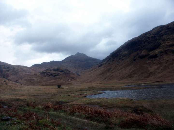
I rock hop and bog hop along the path. Across the loch, I see the tops of mountains sprinkled in snow and the occasional small island out in the middle. I reach Barrisdale at 4.15. The mountains draw aside to reveal an area of flat grassland around a remote and windy bay. As I walk along the shoreline to a copse of conifers shielding the bothy and campsite, a red deer stag jumps across the path in front of me. It stops about ten metres away and stares at me as I take a picture. Then it turns and bounds up a hillside.

As the wind pounds against my pack, I stop and study two of the Munros that I intend to climb (the third one, Meall Buidhe, is out of sight). Across the bay, Ladhar Bheinn rises to a point, with a jagged ridge leading down from its summit. To my left across the grassland, tomorrow’s peak Luinne Bheinn is more rounded. I will hopefully climb both peaks over the next couple of days.
It’s a struggle to pitch my one-man backpacking tent in the swirling wind. I lose one of the lightweight plastic tent pegs to a sudden gust, and eventually I have to move all my stuff to a more sheltered spot in the lee of the bothy. Then the rain starts lashing down, and as darkness falls, my fingers become too cold to tie some of the knots for the guy lines. I have to stop and get my head torch out to finish the job. I’m wet and shivering by the time I throw all my gear through the door and flop down inside the tent.
I know the key to getting warm again is to keep moving, and I still have a few more tasks to perform before I can rest. I unpack my rucksack and assemble the Trangia stove. I need water for tea, so I unpack two saucepans, climb out of the tent and fill the pans from a stream 20m away. Back in the tent, I inflate my Thermarest, unpack my sleeping bag and change into a dry set of clothes. Then I boil some water for a nice hot mug of tea and put a pan on the stove for my dinner of Lancashire hot pot.
The wind and rain continue to batter my tent, but by the time I’ve finished my dinner and settled down to write my diary, I’m cosy and warm inside my sleeping bag, and my fingers are working again. By 8 o’clock I’m ready to turn in for a good night’s sleep.

Friday 9 November, 2007 — Inverie, Knoydart, Scotland
Today doesn’t quite go to plan.
I wake up at sunrise, 7am. But by the time I’ve breakfasted, packed my things and put away the tent, it’s 8.30 when I finally start walking. This gives me about eight hours of daylight to walk fourteen miles over two Munros, carrying 17kg; and preferably find somewhere to pitch my tent in Inverie before nightfall.
Ambitious? No shit.
Aware that time is tight, I set off at a punishing pace. The first section up to the Mam Barrisdale, the pass between Barrisdale and Inverie at 450m, is reasonably easy walking on a good trail. To my left the summit of Luinne Bheinn, my first target, looks intimidating with its thin cap of snow. But it’s also very beautiful.
Lots of red deer are bounding about beside the path; I see one large herd and several lone stags with splendid antlers. It’s the rutting season now, when the stags fight to secure mating rights over the hinds. I yearn to see two stags barking and charging each other, but it doesn’t happen. It does cross my mind whether stags have been known to charge humans. I consider it unlikely, which is just as well.
In Scotland the deer stalking seasons lasts from August to October. The last wolf in Scotland is believed to have been killed in 1680 and the deer no longer have any natural predators. Every year they are subject to a cull to reduce their numbers. I guess these animals must be afraid of humans, but I’m glad to be carrying a trekking pole on the off chance I need to fend off a rutting stag.

Halfway up to the pass I look back and see a fine view across Barrisdale Bay. I reach the pass shortly before 10. The summit of Luinne Bheinn is drifting in and out of cloud, but there’s enough visibility to see the route ahead. I leave the main path. For about a kilometre I skirt the mountain on a boggy mud-riddled path following a line of fence posts, before diverting off to the left to climb steep tufted grass up to a col. I’m still about 300 vertical metres below the summit, but the snow beneath my feet is already quite deep. It’s bitterly cold and I stop to put my fleece on beneath my windproof jacket. I take out my GPS in case navigation gets tricky.
The final section up to the summit is steep. From time to time I find a path to take me up easier terrain, but there is too much snow to see the trail all the time. I start to become tired, but conscious of the need for speed I press on at a good pace. I reach the summit at 11.45. It has taken a little over three hours. I have only about four and a half hours of daylight left to complete today’s walk.
It’s shortly after this that everything starts to go pear-shaped.
I’ve completed about four miles out of the fourteen; there is pretty much no chance of completing my intended route, but the penny hasn’t dropped yet. I’m exhausted when I reach the summit. What I really need to do is stop, take a rest and get my breath back. But I consider time, not stamina, to be the enemy and I press on.
The snow is becoming a problem too. According to my guidebook, there is a straightforward path down to the next col, but there is enough snow to obliterate the route. I can see the col far below me, but there are some cliffs guarding the route down to reach it. As soon as I see a feasible line I head down it, rushing because I believe that any minute the clouds could close in and hide my destination.

I stumble down a steep grassy bank about 200m high and covered with snow. I fall several times hurrying down it. It’s an effort getting up again with my heavy pack, but I stagger on. By the time I reach the col I’m bone-tired and freezing. I can see the ascent to the next summit above the col, and it looks beyond daunting in my present state.
I finally realise that I need to stop, rest and assess my situation before I go any further. I find a rocky outcrop to shelter me from the wind and try to take off my pack. But I can’t. My gloves have soaked up rain like a sponge and my fingers are like icicles. I manage to unclip the buckle of my waistband with great difficulty, but I have so little dexterity on my numb fingers that it takes an age for me to unclip the smaller chest strap. Finally, the pack comes loose and I flop down onto a grassy bank. It’s now 12.30 and I eat my lunch. I struggle to open the wrapper of a Mars bar and blow on my fingers to try and warm them up.
My useless fingers help me to make up my mind. I’m totally exhausted and I need to revise my plans. Heaven knows what state those digits will be in if I go up another mountain; I certainly won’t be able to pitch my tent in this condition. Photography never crosses my mind, which is just as well. I wouldn’t have a hope in hell of operating my camera.
I need to evacuate down into the valley, but how to get down there? To reach the valley trail, I would either need to go back over the summit of Luinne Bheinn, or continue across Meall Buidhe. With the lack of daylight available, both these options are a problem.

I look at my map and see that a small mountain stream descends from the col to meet a larger river lower down. If I follow this river, I will rejoin the main trail from the Mam Barrisdale to Inverie beside a loch. I have no idea if I can get down this way, but I have to give it a try. I suspect that the stream will be guarded by waterfalls, but I hope there will be a way around them.
I’ve now started shivering. The realisation strikes me with a jolt: I’ve reached a state of mild hypothermia and I need to start moving as soon as possible. I tuck my trekking pole under my arm and cross a boggy plateau while I blow on my fingers to get some warmth back into them. When I reach the stream, I need the pole to descend steeper terrain. My stone cold fingers grip the pole like a claw and I pray they won’t get any colder.
I start descending beside the stream, but the route becomes too difficult. I climb back up and around to my left to look for an easier way. I survey the scene. I’m dismayed to see an impassable slab of steep rock descending from the summit of Meall Buidhe to my left. I know I can’t attempt this. To my right, the terrain rises steeply back up to the summit of Luinne Bheinn, where I’ve come from. The slopes meet at a tiny crack where the stream descends. I just have to hope there’s a route down through this minute gap.
But first I have to get down there. I need all my concentration now. I’m supremely conscious that I’m miles from anywhere, on difficult terrain, and nobody in the world knows I’m here. I have no mobile phone signal and the chance of anyone following me down here is smaller than a grain of sand. To slip, fall and break a bone may well lead to a slow, lingering death; or at best, an agonisingly painful, Joe Simpson-like crawl to safety. Probably, my body would never be found; I would be picked at by crows before sinking slowly into the wet grass, emerging 5,000 years later as the Bog Man of Knoydart — a fascinating specimen for archaeologists to puzzle over in the distant future. Long before then, but perhaps not so soon, my car would be found abandoned in Kinloch Hourn, with just a few guidebooks offering a clue to my mysterious disappearance.
I have to focus, remain calm, and above all, be ultra-careful — my life depends on it. I fall several times. Before long I’m covered in blood, snot and bog water. I find myself crossing lines of steep, wet rock in crab-like fashion on my hands and backside. When I reach the gap I’m relieved to discover a way down, but the river is still far below me and there are many more such sections of uncertainty as I make my way down. At one point, I take note of a flat grassy area beside a tiny mountain lake where I could pitch my tent and wait till morning if the route becomes impossible.
My progress is painfully slow. I’m only about halfway down to the river when I look at my watch and see that it’s already 2 o’clock. Relief washes over me when I reach the river and the route flattens out. I know that the difficult part is behind me and I’m free from imminent danger; but the terrain beyond here is still terrible: thick grassy tufts full of hidden, watery sink holes which demand constant attention and continue to slow my progress.
Finally, I see the lake — Loch an Dubh-Lochain — ahead of me. I have a river crossing to make before I get there, but I manage it without getting my feet wet. I reach the main path at the corner of the lake. It’s 3.30 and there is barely an hour of daylight remaining.
I stop and rest. I still have four miles to walk to Inverie, but at least the trail is easy now. As darkness closes in, I need my head torch to descend a steep woodland path into the village. My task isn’t over when I reach the first houses. It’s dark now and I still need to find somewhere to camp. One of my guidebooks tells me that wild camping is permitted beside Long Beach, but Long Beach isn’t marked on the Ordnance Survey map. There appear to be two beaches marked: a long, narrow one and a short, deep one. I head for the former, which better fits the name and also happens to be conveniently located next to the pub.
I get there at 5 o’clock and find a small area of grass between a row of houses and a pebbled beach. The grass is right in front of the pub and is probably the pub garden, though no one is using it in this weather. My tent would stick out like a sore thumb. I ask two people standing outside if I can camp here. It comes as no surprise when they tell me I should camp at Long Beach, the short deep beach a mile back down the road I came from.
I trudge my weary way back along the road. It starts to rain heavily. I have difficulty finding a track down to Long Beach behind houses. At one point I end up in a private field, but eventually I find the beach and walk along it until a sign emerges from the darkness advertising the camping area. Some kind soul has left a large jerry can of water beside the sign and I refill my water bottles.

It’s now 6 o’clock and I’m soaking from head to toes. I pitch my tent, flop down inside and rapidly change into my dry clothing. Over a mug of tea, I consider what to do for the remainder of my trip. It’s obvious that my intended route back over Ladhar Bheinn to Barrisdale will be as improbable as today’s. This means that one day will have to be spent crossing the easy pass over the Mam Barrisdale. I have one spare day. I still want to climb another hill, but the bad weather seems certain to continue. I also want to visit the Old Forge, known as the remotest pub in Britain. It’s one of the reasons I’ve come to Inverie.
As I listen to the rain hammering on my tent, I have no urge to walk back up the road to visit the pub. If I have another difficult day in the hills, then it’s likely I will feel the same way tomorrow. The weather is the deciding factor; it’s piss awful and my clothes are sodden. Although today has been an experience, I can’t claim to have enjoyed it much. As I lie in my tent this evening, the rain is incessant. I can’t bring myself to leave the tent and fill my water from the jerry can three metres away. It’s even too cold to sit up and write my diary.
I decide to bring my sorry escapade to a more comfortable conclusion. I’ll spend tomorrow in Inverie and visit the pub, and the next day I’ll take the easy route back to Barrisdale.
As I go to sleep, the rain starts pounding on my tent once again, and I have no regrets.

Match abandoned
And that was that. The following day I pottered around Inverie in the driving rain. I found a wildlife hide at the far end of Long Beach, where other visitors had recorded otter sightings in a logbook. But it was too wet even for the otters that day and I saw none.
I spent two hours in the Old Forge — ‘the remotest pub in Britain’ — trying to get warm. There was a framed magazine article on the wall describing Rob’s Run, a 77-mile journey from a remote loch north of Knoydart and ending at Inverie. It took Rob, whoever he was, four attempts to complete his epic. On the first occasion, the weather was so bad that he had to be evacuated with hypothermia. He quit his second attempt when his companion broke an ankle, and the third attempt was also abandoned through bad weather and exhaustion. Poor Rob; I knew how he felt, but he was more persistent than I was. On the fourth attempt, he completed the run in 46 hours, with just a brief stop for some sleep in Barrisdale. There was a note at the end of the article telling readers to let the pub know if they were intending to give it a go themselves. I didn’t know if it was meant as a joke.
I walked for about an hour up the road west of Inverie, hoping to see more of the peninsula, but it was so misty I could barely see the hills on the opposite side of Loch Nevis. It rained all day, and I spent the evening cowering in my tent, listening to the wind batter on the fabric, with no desire even to walk a mile up the road to the Old Forge.
It was only on the final two days that I was able to relax and enjoy the Knoydart peninsula. After my epic day on Luinne Bheinn, I decided to abandon the hills and take the easy route back over the Mam Barrisdale and along the coast to Kinloch Hourn. At last, the rain relented, and with more time to spare, I was able to enjoy the scenery and the tranquillity of Knoydart in winter. It was bitterly cold though, and when I reached my car in Kinloch Hourn and turned on the engine, it was the first time I’d been really warm in five days.
For sixteen years, those were my memories of Knoydart.


Wow, what an account. Inverie and the Old Forge is one of my favourite places in the world. Mainly due to the fact I’ve enjoyed several trips over from Glenfinnan. The weather, on occasion, has been terrible, and I’ve experienced two nights camped on Long Beach, similar to yours, after difficult hikes, but not quite as nerve wracking. As I was reading your blog I was waiting for you to say you’d found the wooden structure near the beach or even the compost toilet, which, if I’d been through what you had, I’d have been tempted to bed down in. However, I then looked back at the date and realised that neither would have existed in 2007, nor would the bunkhouse hostel, a great place to stay after a 30 mile hike btw. Brilliant blog, thanks again for sharing. Kept me on the end he of my seat, knowing the place well, as I do, made it all the more riveting.