
This is part 2 of a brace of posts describing a wild camp and hill walking east of Glen Nevis in the Scottish Highlands. The first post described an ascent of the Mamores on the south side of the valley. This post describes an ascent of the Grey Corries on the north side.
The second day started with the excitement of fording the river. Both the maps.me app and a couple of guidebooks indicated a crossing point at Luibeilt, but it wasn’t obvious. It was easy to get halfway across by means of a large submerged slab on our side of the river, but the rest was going to involve deeper wading.
We’d been expecting a deluge, and had brought Crocs and flip-flops for the task. The crossing presented few challenges until one of my flip-flops decided to take a swim. Luckily I was able to grab hold of it before it shot off towards Loch Treig, and I managed to hop the remainder of the way without falling into the drink.

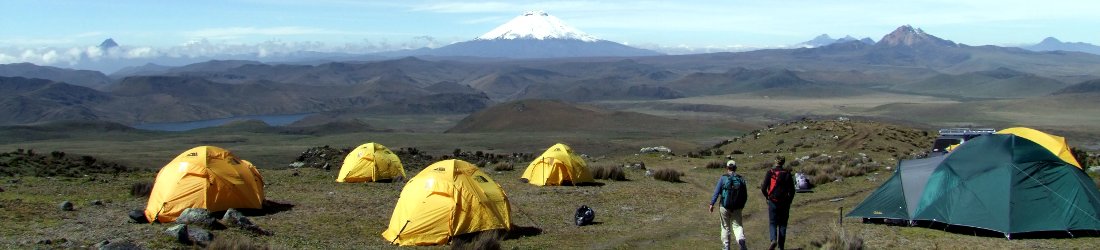
Our plan for the day was to climb the Grey Corries on the north side of the valley. This long horizon of peaks is drizzled in a silver top when viewed from afar. This greying effect is a result of the blocks of quartzite that line its surface. Quartzite is a type of stone formed many moons ago by sandstone that has been heated and compressed by tectonic pressure. Its surface comprises a mosaic of interlocking quartz crystals that glisten white when viewed in close-up.
Some of the earliest mountaineers, including Jacques Balmat, who made the first ascent of Mont Blanc in 1786, were crystal hunters who climbed the mountains looking for precious stones. I don’t know whether untold riches are available in the Scottish Highlands, but I’d carried a massive pack up from Kinlochleven a couple of days earlier, and I had no intention of lugging a bag of rocks back down again.
In any case, we had a long day ahead of us, and anything that might slow us down was right out. We had an ambitious plan to complete a full traverse of the ridge across the seven summits of Stob Choire Claurigh (1,177m), Stob a’ Choire Leith (1,105m), Stob Coire Cath na Sine (1,079m), Caisteal (1,106m), Stob Coire an Laoigh (1,116m), Stob Coire Easain (1,080m) and Sgurr Choinnich Mor (1,094m). Only three of these — Stob Choire Claurigh, Stob Coire an Laoigh and Sgurr Choinnich Mor — are Munros, so for completeness’s sake we would first have to climb the small outlier of Stob Ban (977m, which is also a Munro), then descend nearly 200m to a bealach (col) before climbing back up again to gain the ridge.
Hampered by my injured ankle, we’d been out eleven hours the previous day and arrived back at our tent just before pitch blackness. We’d managed only three out of four summits, but we’d completed a route that enabled us to take one peak at a time. Today, beyond Stob Choire Claurigh, we would have no option to retreat. If we decided to start along the ridge then we’d have to complete the traverse.

I decided that we should try to get to Stob Choire Claurigh by 1pm to give ourselves enough time. We left at 9am and were soon across the river, where we stopped to put our shoes and socks back on.
Like yesterday, I expected to be bog-hopping for most of the morning, and after stumbling across boggy heather for a few hundred metres, I was pleasantly surprised to join a good, firm trail beside a bubbling brook. This trail headed north to a narrow valley, the Lairig Leacach, that cuts through to the main road and the village of Spean Bridge on the northern side of the Grey Corries. Its existence enabled us to make quick progress for the first 1½km and gain 200m of altitude with little effort.
Eventually, however, we needed to leave the trail, cross the brook at a shallow place with boulders, and head northwest across tussocky bog. Our target was a 750m col between Stob Ban and a rounded grassy summit called Meall a’ Bhuirich.
The terrain was tedious and it was hard going. The land gradually steepened as we approached the col and we picked a route that skirted above crags. We stopped for a sandwich just below the col to give us some energy and look back across the wild moors that we’d gradually ascended.
We reached the col at 11am, and had our first view of the full ridge. We’d not seen the weather forecast for a couple of days and although the sky was overcast, the clouds were well above the summits and things looked well set for a pleasant ridge walk with decent views.

The going was much easier above the col — no more than a gentle grassy hillside that we plodded up slowly. The rounded silver top of Stob Ban came into view, we found a route across the mass of quartzite rubble that lined its flanks, and we reached the summit of our first Munro at 11.45.
Far below, in a dark green basin, we could clearly see the five lonely pine trees that marked the position of our camp. To the north-east, the Grey Corries ridge was still clear. The next peak of Stob Choire Claurigh rose across a deep gap, another 200m above our present position. It didn’t look so far away and we were still on track to reach it in good time. But beyond the eastern Mamores to the south-east, the clouds were an ominous dark grey and it looked like rain was heading our way.
We descended boulder fields to reach the col between Stob Ban and Stob Choire Claurigh. It was slow going for my injured ankle and I dropped behind Edita. A cold wind hit us at the col, but we found a rock outcrop to shelter behind to grab another sandwich and get some energy for the climb ahead.
We’d stopped at just the right time. By the time we set off again, the rainstorm had reached us and we were deep in cloud. Rain lashed us from the left and we huddled into our hoods. I followed a faint track around the side of a small lochan; then the track turned sharp right to climb up Stob Choire Claurigh’s grassy south ridge.
The rainstorm remained with us for the entire ascent. The distance hadn’t looked far from Stob Ban, but it became a tedious slog. We plodded on. The faint track disappeared from time to time as it crossed boulder fields, but I was able to find it again on the other side. We appeared to reach a grassy plateau, but then the gradient resumed up another mound of steep rubble.

Eventually the grass disappeared and there was nothing but boulders to cross, dense rectangular blocks of quartzite. It was a sign that we were finally reaching the top.
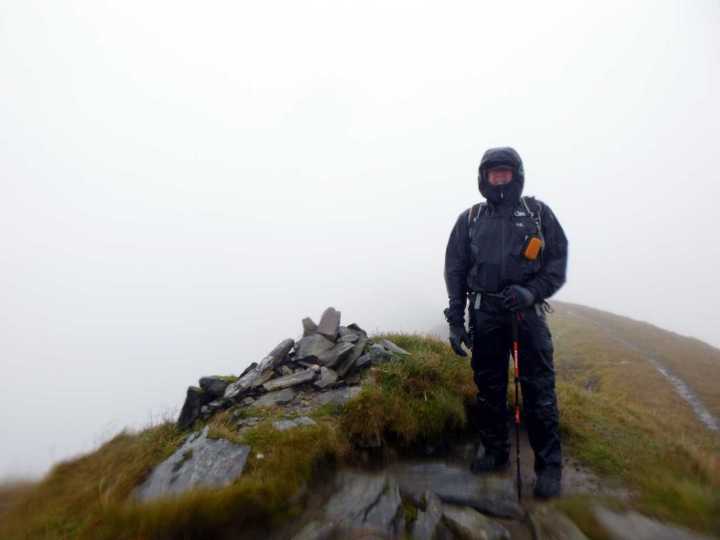
We stepped onto Stob Choire Claurigh’s spacious summit at 1.30. The very top was marked by an untidy heap of stones and there was a smattering of grass. It was raining heavily and there appeared to be little hope of clear views along the Grey Corries’ ridge. But there was enough visibility — about 100m of it — for us to see the way forward.
This was our decision point: to continue onwards or to turn around and go back the way we came?
‘We have about seven hours of daylight left,’ I said to Edita. ‘If we carry on from here then we’re going to have to do the whole thing.’
‘What do you think?’ she said.
‘It’s enough time, but it’s going to be a long day.’
‘Then let’s do it.’
In some ways the weather was going to work in our favour. If it carried on like this then there would be no temptation to hang around.

I used the modern method of navigation, which involves walking a few metres in what you think is the right direction, and seeing if the pin on your favourite mapping app (in this case the OS Maps app) moves the right way. This was a decision I was to regret (as I highlighted in a previous post).
We walked briskly down a ridge about 5m wide, grassy and heather-clad for the most part, but aproned by quartzite rubble on its edges.
For a few brief minutes it looked like we might be in luck as the clouds parted and the route opened out before us. First Stob a’ Choire Leith, a non-descript bump on a grassy ridge, then Stob Coire Cath na Sine, a slanting ridge of sloping slabs, then the start of the ridge to Caisteal, appeared out of the gloom. We could see forested lowlands to the north as two men in red waterproofs overtook us. They were the only other hikers we saw all day (we saw them again later in the day returning from Sgurr Choinnich Mor).
The brief clearing in the clouds wasn’t to last. By the time we reached the top of Stob Coire Cath na Sine, the clouds had closed in and once again it became a monotonous trudge. Rain was intermittent, but the cloud was incessant.
Beyond Caisteal, we took advantage of a break in the rain to have a sandwich on a grassy bank. Then we continued without stopping, over the summit of Stob Coire an Laoigh, our third Munro which we reached just before 3pm. We turned to the right, descended, then climbed back up to Stob Coire Easain. Then we turned to the left and descended steeply to Bealach Coire Easain. This section involved some easy scrambling down boulders and there was one exposed move.
Sgurr Choinnich Mor was a long, muddy ridge. Its summit cairn was so innocuous that we almost walked right past it without stopping.
By now I was running out of energy and it was raining pitilessly.
I was concerned about the descent. Until now, the edges of the ridge had been steep. There appeared to be no escape routes on the southern side. My plan was to continue down to the col between Sgurr Choinnich Mor and its sister peak Sgurr Choinnich Beag, then descend for hundreds of metres down trackless grassy slopes to regain the Nevis watershed.
We stopped behind a rock for sandwiches and a snack. The rock provided as much shelter as the roofless building at Luibeilt, but the food was what I needed.
Down at the col, I was relieved to see that the gradient of the hillside seemed more manageable. Down, down, down we went across bogland. My feet were wetter than a pair of soggy fish swimming in a saucepan of water. Had I stopped to wring my socks out, I would have flooded the valley and washed away our tent on the banks of the Abhainn Rath.

After about 200m we emerged beneath the cloud line and we could see the valley below us. Features looked deceptively large in the gloomy light. Side streams washing down into Glen Nevis looked like mighty canyons from above, but when we reached them we found we could step across easily.
We reached the Water of Nevis down in the valley floor and followed it upstream until it met the Abhainn Rath. We had to cross to the south side to reach our camp. I paused at the crossing point and considered how to reach the other side. But Edita saw no reason to pause; she simply waded across in her shoes. She figured that her feet were so wet there was no point changing into her Crocs. I followed her across.
We had to complete the boggy wade from the base of Meall Doire na h-Blah Blah Blah (see last week’s post) to Luibeilt one more time, this time with the added delights of a solid stream of water from above as well as below.
We reached the haven of our tent at 7.30pm. It had taken us nearly as long as yesterday. As the rain hammered on the roof of the tent, we appreciated the bottle of wine we’d carried up from Kinlochleven. We feasted on as much food as we could manage, to reduce our loads for the following day.
The rain continued all night and into the morning. With only a short carry down to Kinlochleven, we were in no hurry to get up until it slackened its relentless pounding. This didn’t happen, so after countless brews of coffee and tea, we started packing away our things at 9.30am.

Overnight, the Abhainn Rath had become a mighty torrent. Had we been climbing the Grey Corries today, we’d have had problems getting across. The crossing point had been transformed into grade VII rapids.
We packed up the tent, strapped it to the outside of my pack and began the slow plod back to Kinlochleven at 10.30. My feet became wet almost immediately. The rough vehicle track was flooded in many places and we had to take diversions around the side.
For the first two hours, the rain continued mercilessly. It slackened off in the afternoon, but by then my injured ankle was protesting at the weight. I plodded along like a tortoise as Edita shot ahead. Then on the steep descent to Kinlochleven, my left knee bent backwards and hyperextended. I was able to complete the descent, but at a speed that would have caused a snail to blush.
It wasn’t the end of our holiday. This was just the first week. In spite of tendinitis in my right ankle, we’d climbed seven Munros and enjoyed (somewhat) a wild camp in a remote location, but there was more to come and now I had a new injury to contend with.
We had booked a climbing guide for the second week, and our aim was to complete the two-day traverse of the Cuillin Ridge on the Isle of Skye. That seemed inconceivable now, but could anything be salvaged from our trip?
To be continued… and you can see all my photos from the trip here.


