
Let’s start by explaining the amazing pun in the title of this post, or some of you who have tuned in hoping to hear With a Little Help from My Friends sung by a male voice choir might end up disappointed.
‘Fawr’ as many of you know, is the Welsh word for ‘Big’. Hill walkers will be well familiar with it; many Welsh mountains come in pairs, with a Fawr (big) and a Fach (little). The Rhinog Hills, a coastal range in southern Snowdonia, has two such peaks and four main peaks in total. This trip report covers an ascent of three of them, including the most rugged, Rhinog Fawr.
That’s almost as far as my Welsh goes. In the spirit of learning, I therefore typed the word ‘rhinog’ into Google Translate. It came back with ‘rhinoceros’. With eyebrow raised, I tried ‘Rhinog’ with a capital. This time it returned the answer ‘Horned’. Well, at least there was a connection. This can mean one of two things: (a) in the distant past, giant horned ungulates strode the Welsh mountains, terrorising sheep, or (b) Google Translate uses AI, which famously just guesses when it doesn’t know the answer.

It turns out that the answer is (b). In the Collins Rambler’s Guide to North Wales, Richard Sale explains that ‘rhinog’ means ‘doorpost’. The name refers to the position of the two most northerly peaks, Rhinog Fawr and Rhinog Fach, rising either side of the Drws Ardudwy, the most obvious pass through the range (‘drws’ itself means ‘door’). This seems more plausible. Rhinog Fawr (720m) and Rhinog Fach (712m) are not actually the highest peaks in the range; both Y Llethr (756m) and Diffwys (750m) to the south, are higher.
Talking of height, the Rhinogs are not the most lofty peaks in Britain. They don’t even make it into my guidebook The High Peaks of England & Wales, which lists all the peaks over 2,500ft (762m). What they lack in height, however, they make up for in toughness. Paths are faint, steep and rough, often disappearing into rocky shelves. The peaks feel wild and remote (even though they are not that remote); they provide a strong sense of being off the beaten path.
They had me staggering in exhaustion on my only previous visit fifteen years ago. I drove up from London for two days of backpacking on a sweltering weekend in June. I had already drunk my only two litres of water when I arrived on the summit of Rhinog Fach at 2.30pm. Expecting a nice easy ridge between Rhinog Fach and Rhinog Fawr before dropping down to my campsite for the night, I was surprised to find a deep cleft of nearly 400m.

I staggered down to the bottom, collapsed in the grass and slept for half an hour, before the sound of running water brought me to my senses. I found myself sleeping in a mossy boggy. Fortunately the water looked fresh and I was able to refill my bottles. Unfortunately, I had lost the path, and my climb back up to the summit of Rhinog Fawr over rough boulder fields was almost certainly a new line, still unrepeated. It was 8.30pm before I reached my campsite.
I returned to my car the following day over foothills on the west side of the range. The proximity to the coast meant that the Irish Sea was ever present and there were fine views west across Cardigan Bay to the Lleyn Peninsula.
I fancied a change of scene on my second visit. This time I plotted a route up Rhinog Fawr, Rhinog Fach and Y Llethr from forests on the east side of the range.
In the Cicerone guidebook Ridges of Snowdonia, Steve Ashton describes seeing these three peaks from the A470, the main north-to-south route across the spine of Wales, which passes to the east of the Rhinogs.
What an uninspiring sight it is: grass on grass, the distant humps of little hills. Hump, hump, hump.
I guess we’re all different. I had only passed along this road once before, and I remember being quite taken with the Rhinogs rising up to the west. It was one of the reasons I decided to go backpacking there. Perhaps I’m more keen on humps than he is.
Arriving there for a second time after a long drive up from the Cotswolds, I couldn’t help but agree with my earlier impression. The peaks stand in a line about 5km from the road, and rise abruptly across gently sloping grassland. This grassland deceived the pilot of a private helicopter, who flew across it in thick fog in 2017, missed the doorway and slammed into the east face of Rhinog Fawr, killing everyone on board.
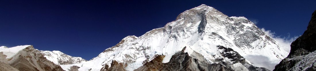
All three of our peaks had their own distinct character. Y Llethr appeared as a prominent triangle, though I remembered it as a broad grassy plateau. Rhinog Fach occupied more of the skyline, from that angle it was a long ridge with no distinct summit. By contrast to its right, Rhinog Fawr rose alone, a single, standalone wall of rock rising abruptly above the grassland.

We had passed through a blanket of fog on the drive up. Although the fog had lifted, the sky was still quite hazy as we turned off the A470 and passed through a pair of gates to arrive at a forestry plantation. A small parking space on the edge of the forest was marked on the Ordnance Survey map as Graigddu-Isaf.
It felt like a gloriously sunny day as we ascended gradually through the forest on a good trail. It was, but there was to be a sting in its tail. The path left the forest and started rising on a series of moorland terraces, heading for a col on the northern side of Rhinog Fawr. Before reaching the col, the path turned south abruptly to contour up the face of the mountain
We reached a small lake, Llyn Du (Black Lake) at about 500m. The summit of Rhinog Fawr reared up in a wall of sloping grey slabs. There appeared to be no obvious route up, and it looked forbidding. My OS map indicated a route, though, and sure enough, a very faint one took us between the slabs in a series of zigzags. Although it was steep and tiring, there was no scrambling.

We arrived at the summit shortly before midday. I had promised Edita a fine view of the Irish Sea, but I was dismayed to find that although the sun was bright, the sky was so hazy that we could barely see it. Although the coast was only 8km away, the view beyond it was grey; if I didn’t know better then I could easily have mistaken the coastline for the horizon. There was no chance of seeing the Lleyn Peninsula 25km beyond that, or the Snowdon peaks to the north.
We could, however, see Rhinog Fach and Y Llethr to the south, rising as two long plateaus divided by a V-shaped gap. Between us and them was the doorway of Drws Ardudwy, which I now knew lay beneath a huge drop of nearly 400m. Having rested on the grass down there 15 years ago, I also knew that there was no direct route down: we would have to descend Rhinog Fawr’s east side on the Cambrian Way, before traversing around to the pass.
Neither of us were hungry, so we continued across the summit and started descending. We passed an older couple on their way up, who were eager to know our plans, so we stopped for a chat. The man had craggy features and a neat grey beard. Edita tried to draw him into a conversation by repeating the story of my backpacking trip to the Rhinogs, which I had described on the walk up.

‘I recognise him. He’s a famous mountaineer,’ she said after they left.
I know who you mean,’ I replied. ‘Steve Berry.’ (One of the founders of the trekking agency Himalayan Kingdoms, whom we had met at a talk a few years ago.) ‘It’s not him though.’
But it turned out that she meant Joe Brown.
‘That would be a surprise,’ I said, ‘given that he died a few years ago and would now be about 100.’
We became separated on the way down after I lost the faint trail during a conversation. I started crossing rough banks of heather to rejoin the trail further down, but Edita set off on a more direct route towards Rhinog Fach. I heard her calling as I regained the trail and waved frantically until she spotted me.

It was a lucky escape. On the south side of Rhinog Fawr the terrain is steep and craggy, and it’s not a place to get lost. Somewhere on these slopes was the wreckage of a helicopter whose occupants were not so lucky. We said nothing as we reunited.
Just above the doorway of Drws Ardudwy, we reached a stone wall with no stile across its top, only a small opening in the base just big enough for a sheep. Edita threw her pack in front of her and crawled through. For my part, I was doubtful I would be able to fit. I had visions of getting stuck halfway; Edita would end up having to call mountain rescue after trying unsuccessfully to haul me out by the trousers. I didn’t want to be that prize idiot everyone is talking about on social media, ‘… and you know what, he wasn’t even wearing any trousers. These people should carry a map and compass and know how to use them.’
I decided to climb over the wall instead.
There was a large slab on the other side that looked like a good place to stop for our first lunch. As we ate, we looked down and saw a good trail passing through the gap between Rhinogs Fawr and Fach. But our route went straight across it and up the other side. From where we were sitting, there appeared to be no obvious way up.

In Ridges of Snowdonia, Steve Ashton said that ‘whoever designed the path up Rhinog Fach from here must need his head examined’. This time I was minded to agree with him. The way was steep and direct. I could see that the trail on the map went straight up what appeared to be a stone chute. It looked so improbable that Edita didn’t believe me when I said it was the trail.
But appearances can be deceiving. When we got there, we found that the stone chute was actually just a steep, rocky track. Edita raced up it. I plodded slowly behind. I had picked up a ticklish cough and I realised that – just like on my previous visit to the Rhinogs – I hadn’t packed enough water. The air had become unseasonably hot I was becoming dehydrated. But I knew that we still had a long way to go and I would have to save some water for later.
After 200m of steep ascent, the trail took a kinder, more sensible route off to the left and back again on a gentle arc. There was a final steep haul to reach Rhinog Fach’s long summit ridge that we had seen from the road. The summit itself was at the far end. We reached it at 2pm.

It was still too hazy to see the sea. We stopped for selfies and moved on. On the other side of the summit we paused above cliffs to look across the silver waters of Llyn Hywel nestling 100m beneath us on the col between Rhinog Fach and Y Llethr. The sun glinted on the surface of the lake, creating a shimmer like ice. It was an amazing view, but we wouldn’t be able to get down that way without flying. We reversed our tracks and found a less severe route down to its shores from the east.
I remembered Y Llethr to be a much easier peak than either Rhinog Fawr or Rhinog Fach, but I had descended it in the opposite direction. I was therefore surprised by the steepness of the ascent on an eroded earth track like a speedway arena tilted on its side. It was only 150m of ascent, but I puffed and panted my way up as Edita raced ahead. I couldn’t help thinking that the Rhinogs had knocked me out for a second time. Is it possible to climb these hills without getting completely knackered?
Another hiker was waiting for me as I reached the top. He tried to strike up a conversation, but I was sparing my energy for walking. I grunted an acknowledgement and continued onwards.

In contrast to its jagged neighbours, Y Llethr’s summit is a grassy field with a stone wall across its top. We arrived beside the summit cairn at 3pm. After a couple of quick selfies, we sat on the grass a few metres to the west and had our second lunch. We squinted through the haze and tried to make out the sea. I was baffled to be so close on such a sunny day and still be quite unable to see its big blue vastness.
Edita was due to fly back to Haiti for work the following week, but she received a text message suggesting that her flight was in doubt. Our moment of rest and solitude was somewhat marred as she made phone calls to find out what was going on. I ate all my food then rested my head on my pack as I waited for her to finish.
It was 3.45 by the time we were ready to move on. We still had a long descent to return to the car. There was plenty of time, but I did worry about those damn gates across the road. There are lots of stories about such gates getting locked at dusk to discourage people with camper vans from staying overnight. Of course, there’s no better way of getting people to stay overnight than locking their cars inside so that they can’t get out. But not everybody who puts two and two together comes up with four. It’s rather like stopping drunk drivers by giving them free beer.

We followed the path for 50m down the south side of Y Llethr to a col. The fourth peak, Diffwys, lay an hour’s walk away along a curling grassy ridge, but it would have to wait for another day. We crossed the wall over a stile and left the ridge. A narrow path, more like a sheep track, doubled back and contoured down Y Llethr’s east side. It was an easy and picturesque trail; we descended rapidly until we reached another lake, Llyn y Bi, at the base of the mountain.
Then things became decidedly sticky. The forest where we’d parked the car lay hidden behind featureless foothills, and the terrain was confusing. It took us another hour to cross 2km of wearisome bog. It was relatively dry bog, but the ground was rough and it was hard going.
The path was far from obvious and demanded concentration. I was tiring and needed to focus my attention on putting one foot in front of the other. I was glad when Edita took over the lead. She set a good pace and I followed behind. For much of the crossing we had no idea where we were heading, but I could follow a line on my OS app to confirm that we were on the right route.

It was a big relief when we crested a rise and saw the forest to our left. We knew that our car was parked somewhere on its fringes. We reached the firmer ground of a farm track and followed it north for half an hour to reach the forest. From there, it was another half hour along forest trails.
By then we were moving rapidly again. We reached the car, exhilarated, at 6pm after eight hours of some of the toughest hiking in Britain.
There was a tense moment as we were driving away, when Edita got out of the car to open the second gate, and decided to play the clown by pretending it was locked. My heart was starting to sink when she magically swung it open.

We drove south for 20 minutes and enjoyed a memorable evening at the George III Inn, overlooking the Afon Mawddach estuary at Penmaenpool.
You can see all photos from our walk in my Rhinogs and Arenigs Flickr album.
Route map
Rhinogs from Graigddu-Isaf
Total distance: 20.47km. Total ascent/descent: 1,254m.
View route map and download GPX


