
This is the last of three posts about our Xmas and New Year trip to Scotland’s southern highlands, trying to tick off some more Munros (mountains in Scotland over 3,000ft in height). In the first post, we tackled Beinn a’ Chochuill and Beinn Eunaich, in the second Ben Lui. It was time for Ben Cruachan…
We saved the best walk for the best day. Edita and I had spied Ben Cruachan’s airy summit and hair-raising summit ridge from the top of Ben O’Cockle two days earlier. I could also see from the map that the walk across its top and that of its companion Munro Stob Daimh featured an enormous ridge. This was what had been missing the previous day when I found Ben Lui not all it’s cracked up to be.
IMO, much the most enjoyable walks are those along ridges, high above the surrounding landscape with long views to distant horizons. You get those from summits, of course, but then you move on, back down again on knee-jarring descents. That had been the case with Ben Lui and Ben of Cleeves, two peaks linked by a col rather than a ridge: up to a summit, down to a col, up to another summit, back down to the same col and eventually, back down the same ascent path. Apart from an enjoyable lunch atop Ben Lui, it had been hard slog most of the way. Ben Cruachan promised a different style of walk: a circular jaunt round a corrie with some delicious ridges. Or so I hoped.

It was going to be a longer day than the previous one. The Walkhighlanda guidebook estimated an 8 to 9 hour day in summer conditions, with nearly 1,400m of ascent and descent. In fact, the altitude gain turned out to be even greater than this. The conditions were more favourable, though. We knew there would be no snow on the summits. Moreover, the frozen ground promised firm terrain underfoot. I decided to wear my approach shoes rather than the big boots that I’d worn on the two previous days. My feet might get a little colder, but they would be much more comfortable, and I would be a lot quicker.
The route up Ben Cruachan is accessed from a small lay-by on the A85 beside Falls of Cruachan station, one of those tiny branch-line stations where you have to stick your thumb out to flag down a passing train. We had previously noticed that this lay-by gets very busy, and there were already several hikers parked there and getting ready when we arrived in darkness just before 8 o’clock.
We set off walking bang on 8am. I wore my head torch as we walked under the railway line, up some steps and into woodland. For the second day in a row the start of our walk was full on. There was no wading through icy water this time, just a monstrously steep ascent through the woods, with some big steps and plenty of scrambling over tree roots, using the roots as handholds.

I was able to turn my head torch off when we left the woods. The sky was still dim and there was a soft tangerine glow above the shining silver waters of Loch Awe. We were now high above the lake, having been close to its shoreline just a few minutes earlier. Daylight arrived as we ascended a frozen, boggy pathway above the treeline. Treading carefully to avoid puncturing the frosty surface and squidging our approach shoes into the muck, we ascended steeply for a few more minutes before arriving at the service road for the Cruachan Dam.
We were now in a high combe, Coire Cruachan, which was flooded in the 1960s to create the Cruachan Reservoir which feeds the Cruachan Power Station down by the roadside where we left our car. The dark grey walls of the 46m-high Cruachan Dam rose before us. We turned left along the service road to reach its base. A metal staircase led up onto the dam, and the path actually went along its wall for about 50m to reach the corner of the reservoir.
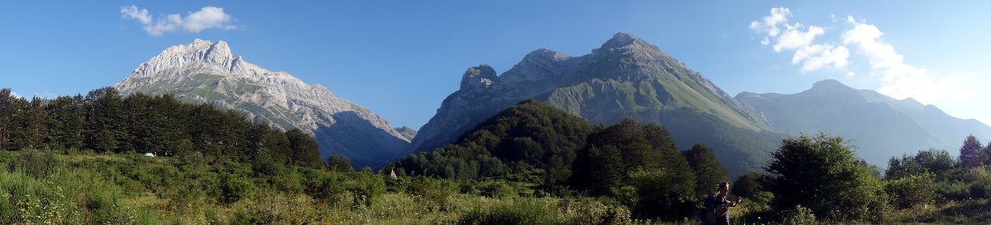
Our walk had been relentlessly steep from the moment we left our car, but we now had some respite as we followed a dirt track for over a kilometre along the left shore of the lake. We didn’t know it yet, but we could actually see almost the whole of the day’s walk along the rim of the skyline surrounding the lake. The triangular summit in the far left corner was the summit of Ben Cruachan itself; the sloping skyline which fell to a modest col high above the far shore was the ridge from Ben Cruachan over the summit of Drochaid Ghlas; and the two small bumps on the ridge above the opposite shoreline were the Munro of Stob Daimh and its sister summit Stob Garbh.

By 9.30 we had reached the end of the road and turned left on a narrow trail that followed the right bank of a small stream up into Coire Dearg. The trail was good, with just a few sections of ice to avoid. Somewhere on the way up we even found ourselves in bright sunshine. The path became steeper and more eroded as we approached the col of Bealach an Lochain, which formed the skyline above us.
We reached the bealach shortly after 10am and sat down beside a small lochan for fifteen minutes to enjoy a sandwich in the sun. We were already at over 800m and had the majority of the ascent behind us. The food gave me the energy to complete the remainder with no great difficulty.
We had our first view of the summit a short distance above the col, a triangular pile of boulders about 250m above. The good path became increasingly rocky and the final section was over a boulder field. From the summit of Ben O’Cockle two days earlier, the summit of Ben Cruachan had seemed an improbable pinnacle, but apart from a bit of rough scrambling over boulders towards the top, it wasn’t difficult. Ben Cruachan means Conical Hill, and while it may have looked like a traffic cone from the opposite side, it was now more like the rough shell of a giant tortoise (which, as usual, was what I had felt like lagging behind Edita most of the way to the summit).

We reached the 1,126m summit at 11am and had much the best view of the week, a 360° panorama which had something different to offer in each direction. I’m not going to describe all 360 of them, but I will provide four. To the north we looked beyond the oblique navy sliver of Loch Etive, across the lightly dusted top of Bidean nam Bian to an unmistakeable shape on the far horizon. Ben Nevis was the only peak with substantial snow cover. It lorded over everything, its profile rising slightly from left to right then dropping suddenly away like a graph of the UK economy after Liz Truss had taken the reins of power.
Looking west, the triangular top of Stob Dearg, also known as Taynuilt Peak, was close at hand. Beyond it, the land was flat all the way to the Firth of Lorn. We could clearly see the islands of Kerrera and Lismore just offshore, but beyond that the view was hazy.
To the south we could see lakes and forests shining in the glare of the sun among a low-lying, crumpled landscape. But by far the most enticing view was to the east. An inviting ridge, steep on its right side and sheer on its left, led over a series of tops to the summit of Stob Daimh over 2km away. We could see Sunday’s peaks (Ben O’Cockle and Ben Eunuch) over Stob Daimh’s left shoulder and Monday’s peaks (Ben Lui and Ben of Cleeves) on the skyline beyond. The ridge was rocky, and was clearly going to offer some rough terrain, but it was also going to provide unparalleled views for most of the afternoon.

Having eaten at the bealach, we didn’t linger on the summit for more food; instead we took our summit pics and sunk our teeth into the prospect before us. Some crab-like bum-surfing took us down the summit boulder heap to join the ridge. Looking back from the base of this section to the summit, I could see why it had looked such a knife-edge from Ben O’Cockle. I was standing in a direct line between the two peaks.
For the next hour and a half, we followed the ridge. We were in sun all the way and it wasn’t cold at all. As I had predicted, the stones underfoot meant that it wasn’t one of those ridges where you can hold your head up and admire the view. With every step, I had to concentrate on where I was putting my feet. At one point, we took a wide bypass path beneath some smooth slabs which looked hazardous. This was probably the wrong option. The path took us a long way down off the ridge and we had to cross some awkward terrain to climb back up to it.
I started to run out of energy as we approached the summit of Drochaid Ghlas. Beyond this smaller peak, the ridge dropped 150m to a col, beyond which the terrain looked much easier. We agreed to descend to the col and find a nice sunny spot for a second lunch before climbing back up to Stob Daimh. It was a steep, awkward descent, but by 12.30 we were sitting on a soft, mossy bank, tucking into a second sandwich.

The view from our lunch spot was deceptive. We could see two high points on the ridge above us. The one immediately above the col looked innocuous. This was 998m Stob Daimh, the second Munro. Standing next to it, south on the ridge, was 980m Stob Garbh, a much more prominent summit that also looked higher. It wasn’t.
As teenagers used to say, whatever. We crossed them both. The walking was easy, and from the summits we had great views back to Ben Cruachan, which now looked like a church, with a pitched roof topped by a spire. Stob Daimh, which means Stag Peak, is actually pronounced ‘Stop Dave’ which, incidentally, is what many people in Scotland wish they’d done to Dave Stewart before he formed the Eurythmics with Annie Lennox.
We had a long descent ahead of us, from the summit of Stob Garbh at 980m to our car at 50m. But it was easily the most gradual descent of all the peaks we’d climbed that week. We eased our way down to the 728m Lairig Torran, which was snowlined, and had a decidedly wintry feel as it nestled in the shadow of the bulky whaleback of Beinn a’ Bhuiridh. Then we descended a gentle hillside basking in sunshine, down to the shores of the Cruachan Reservoir at 450m. It felt like winter had become spring in the time that it took to sneeze.

The path contoured about 30m above the reservoir. This section was less pleasant. In the summer it would be a horrendous bog. The bog water had frozen into icy sheets. We had to slog our way up rough, grassy banks then lollop down again to rejoin the path, only to find another series of ice sheets a few metres further on.
We eventually reached the access road to the dam and followed it in a wide loop to rejoin our ascent route. The worst part of the descent was the steep scramble back through forest, hanging off tree roots with tired legs. But it had been a great day out. We arrived back at the car at 4pm, well satisfied with our three days and six Munros. It was a winter tally we could never have hoped for on any of our previous winter weeks.
The weather was more typical for the three remaining days of our holiday. For the most part it was wet and cloudy down below. When the black clouds parted briefly, we could see that snow had returned to the heights. They were marginal conditions for hill walking, and I was glad that we didn’t feel tempted to go up.

We completed our week with some low-level walks down to the shores of Loch Etive, along the woodland trails of Glen Nant Forest, and around a coastal headland near Oban. The highlight of those days was a sunset visit to Castle Stalker, famous as the Castle of Aaaaargh in Monty Python and the Holy Grail. I was surprised to see that there’s a pub just 50m away from the shoreline where King Arthur’s armies had assembled for battle.
In the place where a police car screeched to a halt in front of the marauding hordes, there is now a cycle track.
You can see all photos from our walk in my Loch Etive and Glen Awe Flickr album.
Route map
Ben Cruachan and Stob Daimh
Total distance: 15.40km. Total ascent/descent: 1,556m.
View route map and download GPX


