
Peak bagging (aka ‘box ticking’) is frequently derided by people who consider themselves to be a better class of traveller. If, however, like me, you’re quite happy to be considered a lower class of traveller, then it has many advantages. It takes you to parts of the world you wouldn’t otherwise go. Some of these, admittedly, wouldn’t be worth travelling to without that elusive tick. But these are far outweighed by the hidden gems and the simple novelty of going somewhere new.
You can also pick your level. For the extreme adventurers, there are the Seven Summits and the Explorer’s Grand Slam. To complete these challenges, you have to be willing to man-haul a sledge, brave extreme cold and extreme altitude, and endure long days of physical activity and – worse – freeze-dried food. At the opposite end of the scale are the County Tops: the highest mountains in each British county. I say ‘mountains’, but they include, most notably, the appropriately named Boring Field, which at 80m is the highest point in Huntingdonshire.

A few weekends ago, Edita and I stood in cold drizzle while I took a selfie in front of a metal fence beside a sewage farm, just because it happened to be the highest point in Nottinghamshire; last weekend we stood beside a junkyard atop the highest hill in Kent. These were examples of those ticks that wouldn’t be worth ticking if they weren’t tickable. But the weekend after our Nottinghamshire excursion there was a good-weather window and we were able to sample one of the gems, Aran Fawddwy, the highest point in Merionethshire.
Merionethshire is the historic Welsh county that embraces the southern half of Snowdonia, with its smaller massifs of the Arenigs, Arans, Rhinogs and Cadair Idris. The county is roughly triangular in shape and bounded by the Irish Sea to the west, the River Dovey (or Dyfi) to the south-east, and the Ffestiniog slate quarries to the north.
The Aran Hills form a north-south ridge extending 14km from the shores of Bala Lake to the sleepy village of Dinas Mawddwy, nestling between hills at a confluence of the River Dovey. The central part of the ridge remains above 800m for more than 2km and reaches up to 905m on Aran Fawddwy, the highest mountain in southern Snowdonia. Rolling bogland on the western side contrasts with steep cliffs to the east. The lake of Creiglyn Dyfi, at the foot of the cliffs beneath Aran Fawddwy, is the source of the River Dovey, which flows for 50km into the Irish Sea north of Aberystwyth.

Legend has it that the Arans were the site of a great battle between King Arthur and an evil giant called Rita Gawr, who sported a cloak made from the beards of all the kings he had slain. Arthur’s chin curtain was the last one the giant needed to complete his collar, and a dual was fought beneath Aran Fawddwy. The legendary king triumphed and instructed each of his knights to lay a stone on Rita Gawr’s body as they passed. The resulting cairn became Aran Benllyn, Aran Fawddwy’s sister peak.
Some versions of this legend place the battle on top of Snowdon instead of the Arans, and claim that the giant’s burial cairn was built on the summit of the peak now known as Yr Wyddfa. Which version you believe is neither here nor there, since the legend is quite clearly horseshit. To build a cairn the size of Aran Benllyn would require around two million knights. Also, if you were an evil giant then I doubt you would put up with the name ‘Rita’. It seems to me that Rita Gawr was no more real than the black knight who defended the bridge in Monty Python and the Holy Grail.
More truthfully, there was a time not too long ago when the Arans were subject to severe access restrictions. Permitted footpaths were delicately negotiated between the national park authorities and local landowners. Guidebooks were filled with warnings about where you could and couldn’t go.
Indeed, one of my guidebooks from 1999, The High Peaks of England & Wales by Paul Hannon, had this to say:
This very unsatisfactory business does raise an anomaly: as most hill farmers seem to receive grants and subsidies to enable them to survive (and reasonably so, if they are looking after the countryside), then we taxpayers are paying them to keep us off the hills!
This unsatisfactory business also became irrelevant in 2000, when Tony Blair’s Labour government passed the Countryside and Rights of Way Act, also known as the ‘Right to Roam Act’. Two million acres of open countryside (mountain, moorland, heath and downs) were designated ‘access land’ and the public had immediate right to ramble across it.
My only previous visit to the Arans was a mid-week backpacking trip when I was between jobs in 2015. It was a scorcher of a summer, yet I saw only one other hiker in two days. I enjoyed a peaceful wild camp beside the lake on the summit of Glasgwm, the main peak on the southern part of the ridge. But the part of that trip that remains most vividly in my mind was when I narrowly avoided splitting my trousers as I leapt a barbed-wire fence while trying to flee from a heard of angry cows.
Eleven years later, I hoped that a return visit to the hills would help me to recover from the trauma of that day, as well as enabling Edita to tick another box. Aran Fawddwy can be climbed on the south side from the secluded valley of Cwm Cywarch. Access is gained up a narrow farm road hemmed in by hedges. I drove for 3km and was grateful not to meet any traffic coming the other way, which would meant having to reverse 3km all the way back again. Despite the uninviting approach, there is a substantial car park beside a farm at the top end of the valley.

We had wondered about snow conditions. It had been freezing and wet overnight, so I expected fresh snow cover. The Snowdon ground-conditions internet feed had reported fresh snow from 400m. I hurriedly packed ice axe and crampons before we left the Cotswolds at 6am that morning.
The 685m satellite peak of Pen Main rose above us, hiding Aran Fawddwy’s summit from view. Its top was drizzled in snow like a giant birthday cake. To its right, the Drysgol ridge that we would be following to the summit was a white wall. I wore my big boots, packed my crampons and strapped my ice axe to my pack. But Edita couldn’t bear stomping up in big boots. She packed microspikes in case of icy conditions and also took her axe.
As things transpired, neither axe nor crampons were needed, but the deep snow and boggy conditions higher up meant that I was glad of my big boots. I chose to take a circular route up to the summit, starting out in an anticlockwise direction by taking a path that slanted above the south side of the valley of Cwm Hengwm. The path was very steep lower down, but became more gradual. At the head of the combe, a little over a kilometre away, we could see that our path swung round to the left to reach the ridge of Drysgol on the opposite side. This was the white rampart that we could see from the car park. Our route up to the summit of Aran Fawddwy followed the crest of this ridge, which looked fairly horizontal.

We started in shade at 9.30am, but the sky was clear and the forecast was for sunshine. Edita wore magic glasses that tinted as the sky brightened. Up ahead of us, we could see that we left the shady south side of the valley at more or less exactly the snow line. It would be bright, and we discussed whether I should have brought my sunglasses.
‘I guess if I get snow blind then you’ll have to drive home,’ I said.
I reassured Edita that I had never heard of anyone getting snow blindness in winter conditions in the UK. The altitude is low, the air is thicker, the sun never gets very high in the sky, and there is still plenty of green around.
‘If anyone got snow blind, then I’m sure it would be all over social media,’ I said. ‘It would be like “these idiots shouldn’t be allowed on the hills. They should carry a map and compass and know how to use them!”’
We reached the snow line at 450m, shortly before arriving on the 571m ‘bwlch’ beneath Waun Goch – this is the Welsh word for ‘col’, and is mostly easily pronounced by trying to bring up phlegm from the back of your throat.

The col was more of a boggy plateau than a true col, and was carpeted with a couple of inches of fresh snow. The view to the east over rolling hills was magical. None of those hills were especially high, but today they were basked in snow and looked remote and mountainous.
From Waun Goch the ascent became more of a slog. We followed the tracks of a lone hiker with size 11 feet, who can have made those prints no more than an hour earlier. The snow was a few inches deep, which made for harder work. I dropped a little behind Edita as we walked beside a fence up to the ridge of Drysgol.
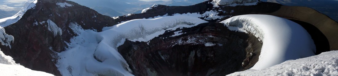
Just below the crest we crossed a ladder stile over another fence and had our first view of Aran Fawddwy. The highest point in Merionethshire peeped above the ridge across another combe. With runnels of snow trickling in cracks down its east face, it looked like a slice of Christmas pudding lying on its side.

It didn’t look so far away, but I was out of breath from the slog and asked Edita if we could stop for a sandwich. We walked for a short distance along Drysgol’s broad, snowy crest. To our left we could look across Cwm Hengwm, whose opposite side we had slanted up a short while earlier. On the right I spied the black pool of Creiglyn Dyli nestling in the combe beneath Aran Fawddwy’s east face. Eleven years ago I staggered more than 200m down Drysgol’s northern side carrying a large pack, and collapsed on the shores of this lake, which is the source of the River Dovey.
Today we stopped on the crest and looked west as we sat down for an early lunch. It was 11am. Ahead of us the ridge rose a little more steeply to a small summit marked on the map as Drws Bach. There appeared to be a figure standing motionless on its top, but after it continued to be motionless while I ate a whole sandwich, I realised that it must be a cairn.
Beneath Drws Bach, the snow had drifted into a thick layer and our walk had a true winter feel. The sizeable cairn was erected in 1960 in memory of a mountain rescue volunteer who had been struck by lightning in the Arans (there are more painful places to be struck by lightning). The plaque was encrusted in ice and unreadable, but I had taken a photo of it on my previous visit.

On a normal day, the section from Drws Bach to the summit would doubtless be a piece of cake, with a clear trail marking the remaining ascent of 150m to the top. But the trail was now hidden beneath snow that was several inches deep. We made the mistake of following the lone hiker’s footprints, which followed a zigzagging fence up difficult terrain. When I left his steps to take a more direct route over rocks, the going became much easier. Edita had been a long way in front of me at the time, and when I popped over a brow ahead of her, she accused me of cheating.
We hadn’t met a single human since leaving the car, but when we reached the summit at 12.30, we found that it was crawling with people, as though they had been magically dropped there.
It had been a tiring final haul to the top. After taking some summit selfies, we sat against a rock on the east side, away from the other people, to eat our lunch. Our view was across the hills beyond Creiglyn Dyli, but the lake was too close beneath the cliffs on which we perched for us to see it. What should have been a peaceful moment enjoying the beauty of the mountains was marred by one of those noisy groups who can’t stop talking.
We intended to continue along the ridge to Aran Benllyn, the Arans’ second summit, but it still looked a long way off. My OS app suggested that it would take 45 minutes to get there and another 45 to come back. But if conditions were like those we had just endured then it would be another slog.

‘We’ve made it to the county top now,’ I said to Edita. ‘We don’t have to go there. We can go down to the pub and watch the rugby.’
But by the time we’d finished eating, we had agreed that to skip the other summit would be a bit lame. In fact, it turned out to be the most enjoyable part of the day. Although we didn’t meet anyone, the path had been well trodden, so the going was a little less strenuous than we had expected.
After dropping down off a rocky summit, we lost sight of Aran Benllyn for much of the traverse from Aran Fawddwy. We crested a long rising brow, following the line of a fence. Once over the brow, Aran Benllyn reappeared in the form of a rocky promontory. We descended to a col and climbed to its summit, reaching the 885m top at 1.30.
It was much quieter up there than it had been on Aran Fawddwy. This gave us more opportunity to appreciate the remoteness and the view. We could see all of Snowdonia’s main massifs: Cadair Idris to the south, the Rhinogs shielding the Irish Sea to the west, the smaller plateau of the Arenigs to the north, and the rolling ridge of the Berwyns to the east. Beyond the Arenigs, the more substantial snowcap of the Snowdon massif rose into cloud.

We traced our steps back to the rocky pile of Aran Fawddwy and skirted its summit. The next part of the walk was a tedious descent, crossing a bog for over 3km as we followed another fence. The first part of the descent involved trudging steeply down drifts of snow that turned the bottom of our trouser legs into white ski boots.
Ladder stiles crossed the fence at regular intervals, causing me to wonder whether we were on the correct side of the fence. Eventually we decided to cross over to the left side, where the trail seemed more obvious. Slippery planks had been laid across the deeper sections of bog. In other parts the track had been paved with gravel, which might have been appreciated on another day. Today these sections were covered with treacherous icy sheets. Edita had chosen to wear approach shoes instead of big boots. Her feet had become soaking wet from the deep snow in the morning and the squelching bog in the afternoon.
For the entire 3km we could see the gully beneath Glasgwm that led down into Cwm Cywarch. This was our exit point from the mountain. It never seemed very far away, but every time I looked on my OS app, thinking we must be nearly there, I could see that we had only come a fraction of the way.
‘Oh, we’ve still got miles to go,’ I said each time, which started to annoy Edita.

Once I realised that we had to cross the bog all the way to the base of Glasgwm before turning down the gully, I stopped looking at my app and became more relaxed.
It was a relief to exit the bog. After turning down the gully, the trail became much firmer underfoot and we descended rapidly. The gully had looked narrow and precipitous from down below, wedged between two steep cliffs; but the trail was clear and nowhere difficult.
We emerged onto the farm track through Cwm Cywarch beside a pair of cylindrical glamping pods. From here it was a short walk back to our car.
We arrived back at 4pm. This was perfect. The Six Nations match between England and Scotland kicked off at 4.40. We were able to drive to the Brigands Inn and check into our room in time for the national anthems. Those of you who watched the match will know that the result was far from perfect for England fans, but it was an entertaining game, and we enjoyed an excellent dinner in the pub afterwards.
All in all, it was a great mini holiday, and another county top had been ticked.
You can see all photos from our walk in my 2026 Flickr album.
Route map
Aran Fawddwy and Aran Benllyn
Total distance: 16.93km. Total ascent/descent: 1,070m.
View route map and download GPX


