
A short distance south of 886m Pen y Fan, the highest peak in the Brecon Beacons (or Bannau Brycheiniog as they are now known), which I wrote about in May, is a range of peaks less well known to the outside world.
The Rhigos Hills form an escarpment on the northern side of an area of Wales known simply as The Valleys, a string of heavily populated parallel rifts running north to south through the upland terrain north of Cardiff. Throughout the 19th and 20th centuries the Valleys were a centre for coal mining and a breeding ground for radical politics. Labour politician Aneurin Bevan, remembered as the architect of the National Health Service, came from the area. People my age who grew up watching the vidiprinter on BBC’s Grandstand every Saturday afternoon will look at a map and recognise the names of many of the towns from the rugby scores: Neath, Maesteg, Pontypridd, Merthyr Tydfil, Ebbw Vale, Abertillery, Pontypool. The area has produced as many international rugby players as left-wing politicians.

The Rhigos Hills stand at the head of the Rhondda Valley, famous for its mining disasters and communism. The name Rhigos derives from the Welsh word grugos, meaning ‘heathery’. While there is heather on those moorlands, nowadays the hills are more foresty, not to mention bedecked in wind farms that can be see from far and wide.
Their highest point, 600m Craig y Llyn, whose name translates as ‘Cliff of the Lake’, shares a distinction with the better known Pen y Fan: both are county tops. Where Pen y Fan is the highest point in the old Welsh county of Brecknockshire, Craig y Llyn is the highest point in Glamorgan.
Edita and I have been gradually ticking off the county tops over the last few years. In England this has meant taking photographs of a lump of granite beside the road, but in Wales it has caused us to visit some interesting hill areas that we may not otherwise have explored (such as a yomp across the giant peat plateau of Great Rhos earlier this year).

Last month, Edita returned from Haiti for a few days’ R&R, so we decided to nip across the border to South Wales and bag the highest point in Glamorgan.
Craig y Llyn lies just off the Heads of the Valleys Road, a 4-lane highway sweeping between high mountains, that was finally completed this year after 23 years. The road cost around £2 billion to build. The near quarter-century of roadworks led locals to christen it the Road to Hell (except that ‘not even Chris Rea would come here’ as one wag put it). I’m sure those who haven’t died of old age during its construction will come to consider it worth every penny. For the time being, before it becomes clogged with traffic as all these fast routes eventually do, it’s certainly fun to drive along.
Leaving the Heads of the Valleys Road at the town of Hirwaun, we drove up to the Rhigos Viewpoint car park on the escarpment edge. To climb the escarpment, this side road took the sort of steep hairpins that attract cyclists like flies to a cow-pat.

It had been a memorable approach by road, but our attention was soon to be drawn to one rather more exhilarating transport route.
As we walked west along the crest of the escarpment, we could see a set of electricity cables descend from a prominent pylon at the top of the cliff. The cable passed above a lake (Llyn Fawr, the lake from which Craig y Llyn takes its name) to reach another pylon in forest far below.
From somewhere in this direction we heard some yells. I thought nothing of it, but Edita was paying more attention.
‘Whoa, look at that,’ she cried.
‘What, I can’t see anything?’

‘There were some people on the cable!’
‘What do you mean?’
‘It’s a zip wire. That tower at the top of the cliff – people are jumping from there.’
I could now see that what I thought was a pylon and electricity cable was something more substantial. I know that zip wires are becoming popular in some mountain areas. Their construction is sometimes controversial because people believe that it destroys the natural environment (which it certainly does, in the same way as cars and roads and houses). I had no idea that I had chosen to climb a hill that was also the site of such a tourist attraction. We were heading directly towards it, and within five minutes we had decided that although it would mean our having to climb the hill twice, if it wasn’t too expensive then we would give the zip wire a go.

A good path passed through grassland dappled with young pine trees. The tower was about 100m off-route, but when we got there it was completely deserted. A locked wooden cage stood at the end of a short metal walkway. There was no evidence that this was a managed tourist attraction. Had Edita not seen the thrill seekers zooming down, then for all we knew it could have been a Welsh version of the The Wicker Man, ready to claim its next victim.
If I had been more observant, I would have noticed a feature some distance below the bottom of the cliff labelled on the Ordnance Survey map as Zip World. I might have wondered why a trouser fastener superstore was marked on a leisure map. Later that evening, I did a spot of googling and discovered that Craig y Llyn is home to The Phoenix, which is advertised as the world’s fastest seated zip line. It turns out that you have to book the ride in advance and meet your guide at the bottom, where you are given a briefing and some useful equipment before being driven up in a minibus.
Disappointed, we continued onwards into pine forest. The highest point in Glamorgan is marked by a white Ordnance Survey trig pillar beside a dirt track. The top of Craig y Llyn is a huge forested plateau, criss-crossed by service roads. A short distance beyond the summit, we emerged from the forest again to see a vast expanse of giant wind turbines stretching to the far horizon, like a scene from War of the Worlds.

Leaving the service roads behind, we found narrower walking trails on the north side of the hill. One path contoured through moorland halfway up the escarpment, with fine views out across the rolling hills of the Heads of the Valleys. Another, more treacherous path descended into the forest and weaved between the pine trees, whose broken branches threatened to skewer me at eye level. At one point I ducked beneath a dead pine that had fallen across the trail. I brought my head up too soon, right onto one of these lethal wooden spikes. I was wearing a baseball cap to protect my shiny pate, but blood was drawn and for the following week I had to attend Teams meetings bearing a scar that made me look like Mikhail Gorbachev.
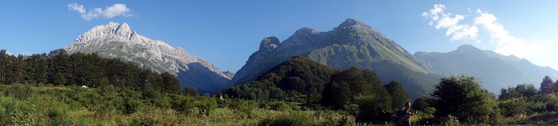
At the bottom of the forest we reached another service road that provided sweeping views north to the Bannau Brycheiniog. I was easily able to identify the twin summits of Corn Du and Pen y Fan on a distant horizon. These two adjacent peaks seem to take the shape of elevated trapeziums from almost any direction, and certainly from the north, west, and now the south.
Before taking a rough trail across the hairpins back up to Rhigos Viewpoint, we had an opportunity to walk underneath the lower end of the zip wire, shortly before another group of screaming thrill riders whizzed past overhead.

If you fancy riding on a zip wire then I imagine this one must be one of the more picturesque. If you’re not busy gazing at the water beneath your feet then the view is extensive, and crowned with the Brecon Beacons if you look far enough.
For the crowded communities of South Wales, this place is within easy reach. For the rest of us it’s worth a short diversion on a trip to the Bannau Brycheiniog. I may come back one day. In some ways our walk felt incomplete; I guess we need to give the zip wire a go.


