
In 2007, I visited Xinjiang, a desert region in the far west of China that doesn’t feature highly on many people’s tourist bucket list.
Wedged between the foothills of three huge mountain ranges – the Karakoram to the south, Pamirs to the north-west, and the Kunlun to the west – the giant snow dome of Muztag Ata (7,546m) rises far above the surrounding landscape of dusty brown peaks. I first learned about it from the writing of Eric Shipton, the great mountain explorer who served as Consul General at Kashgar in the 1940s, a city that was once an important trading post on the ancient Silk Road across Central Asia.

Whenever he could get time off work, Shipton explored the surrounding landscape. On one occasion, his friend the explorer Bill Tilman arrived on his travels and they made an attempt on Muztag Ata. Extreme cold caused them to abandon the climb a few metres short of the summit. But despite its prodigious height, Shipton described Muztag Ata as non-technical, little more than a snow slog. Photographs of its gentle profile in his book appeared to confirm this.
The Chinese teams who made the early ascents of Everest from the north side in 1960 and 1975 considered Muztag Ata to be the ideal training peak. Climbers who performed well on Muztag Ata would also be likely to perform well on Everest. I followed their lead. In 2007, the British mountaineering operator Jagged Globe ran a commercial expedition to climb Muztag Ata. I was in the middle of my own journey to climb Everest. The idea of following in the footsteps of Shipton and Tilman appealed, so I decided to make Muztag Ata one of my Everest training peaks too.
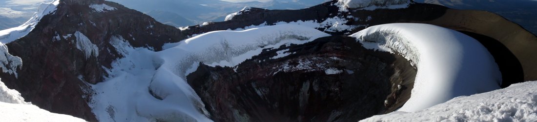
Muztag Ata is a freestanding dome, rather like a giant version of the O2 Arena. It’s enormous, but it isn’t the highest peak in the area. Just to the north is Kongur, a more complex massif of interlinked peaks and ridges. Kongur was usually in cloud during my time on Muztag Ata, and I rarely had a good look at it, but on the few occasions when the sky cleared, I counted at least four jagged summits rising in a line.
I learned that Kongur is a far more technical mountain than Muztag Ata. This was underlined by the fact that its main summit was first climbed in 1981 by a team of legendary British climbers: Chris Bonington, Pete Boardman, Joe Tasker and Alan Rouse.
The Kongur massif is considered to have five main peaks over 7,000m. From west to east these are Kokodak (7,210m), Kongur Jiubie (7,530m), Jangmanjar (7,229m), Karayalak (7,245m) and the main summit Kongur Tagh (7,719m). As the summiteers discovered, the main summit itself has three peaks, one of which, Dongbai (7,625m) is almost as high.

When I returned from our successful ascent of Muztag Ata, I bought a large coffee table hardback of Chris Bonington’s book about the expedition, Kongur: China’s Elusive Summit, fully intending to read it right away. It’s been sitting on my bookshelf gathering dust for 18 years, but earlier this year I finally got around to reading it.
And what an enjoyable read it was. Not only did it bring back memories of my own trip, but it was an engaging story, alive with the spirit of adventure. True to form, Bonington also writes in detail about expedition planning and logistics. While this may be less exciting, it opens an intriguing window into his world. He has been Britain’s most celebrated mountaineer for the best part of 50 years, not just because of his climbing ability, but because in his day he was a master promoter and fundraiser who knew all the right people. The story behind his Kongur expedition is a classic example of this.
The driving force behind the Kongur expedition was Michael Ward, who had been one of the doctors on the 1953 British Everest expedition. Ward happened to be chairman of the Mount Everest Foundation in 1979, when a letter arrived to say that the Chinese authorities had recently opened up eight new peaks for climbing, including Kongur.
The Mount Everest Foundation gives grants to mountaineering expeditions to interesting places. Ward had been hobnobbing with various British and Chinese dignitaries through the 1970s, trying to obtain permission to climb in China. He decided that he was the ideal man to lead the expedition, and that Bonington was the perfect chap to lead the climbing team.
One of the dignitaries Ward had been rubbing shoulders with was a man called Sir John Keswick, who was a former chairman of Jardine Matheson, a well-known Hong Kong trading company. In 1980, the chairman of Jardine Matheson was David Newbigging, who happened to be a keen trekker. During a visit to Hong Kong early that year, Ward and Bonington persuaded Newbigging that Jardine Matheson should underwrite the entire cost of the expedition.

There ended up being two expeditions, a reconnaissance by Ward, Bonington and Alan Rouse in 1980, and the main expedition in 1981 with the full team of four climbers led by Bonington, and four scientists led by Ward, who were conducting research into the effects of high altitude.
Although it’s about as far from the sea as you can get, Xinjiang isn’t a remote area. As well as lying on an ancient trading route with towns and villages all along, it’s been a home for nomadic Kirghiz for centuries, who travel the land with their portable homes (yurts) carried on the backs of yaks and Bactrian camels. Nor did the expedition teams travel alone. They were accompanied by a liaison officer and staff from the Chinese Mountaineering Association, and local staff to transport their supplies.
This didn’t matter though. For the expedition team members, all of it was new, and parts of the massif were still completely unexplored.
From Kashgar, lying 150km to the north at an altitude of 1,200m, Kongur looked like an enormous snow plateau. It reminded Bonington of Mont Blanc and Denali, giant domes of white rising above the surrounding landscape. To reach its foot, they drove along a road through a narrow gorge and emerged onto a high 3,600m plateau. From the shores Lake Karakul they could gaze at the now classic views of Kongur and Muztag Ata across the black waters of the lake, rising a mere 4,000m above.
Bonington and Rouse started their reconnaissance by ascending an unclimbed 6,200m peak on the south side of the massif which they christened Sarakyaguqi Peak after a nearby village. From here they could see K2 in the Karakoram far to the south, which Boardman and Tasker, their companions the following year, were climbing at that very moment. As well as Muztag Ata right next door, the vista included the high Pamirs of the Soviet Union to the north-west, and the Hindu Kush of Afghanistan to the south-west.
Bonington described it as an Aladdin’s cave of unclimbed summits, and evoked the spirit of Shipton:
Technical difficulty seemed of little importance, compared to the joy of finding one’s way up an unknown peak, of gazing around and knowing that almost everything in sight was unclimbed and unexplored.
He relished the prospect of feasting on these peaks with his climbing partner over the coming weeks. But the following day, Rouse sustained a serious ankle injury while running across rocks with a heavy pack.
There is a comical chapter in Bonington’s book called The lack of a Kirghiz phrase-book. It described the hapless adventures of Bonington and his liaison officer Liu Dayi, neither of whom spoke each others language or a word of Kirghiz, as they travelled around from yurt to yurt trying to summon help, never quite sure if anyone understood what was needed.
They nearly drowned crossing a river, and at one stage they went to sleep among the yurts, only to wake up and find the whole community had packed up and left as they slept. Eventually they found a man with a donkey who was able help Rouse back to their base camp as a lonely camel followed behind them seeking companionship.
With Rouse out of action, the older, wiser, but more leisurely Ward took his place. He and Bonington investigated the glaciated Koksel Basin on the south side of the main west-to-east line of summits. Kongur Tagh was hidden from view until they climbed up to a col between 7,245m Karayalak and an attractive 6,715m tower now known as Koksel. Karayalak is the peak on the main west-to-east ridge immediately west of Kongur. To reach Kongur from where they stood they would therefore have to climb the steep, technical spur above them (the south ridge, which Bonington described as a ‘knife-edge rock ridge’) to cross the summit of Karayalak. For this reason they gave Karayalak the name Junction Peak.
An alternative option to the south ridge was an easier spur on the other side of the Koksel Basin, which joined the main ridge west of Karayalak. They would still have to cross Karayalak, but this south-west rib looked less technical.

They had only a brief glimpse of Kongur Tagh from the Koksel Col before the clouds closed in, but it was enough for them to see that the ascent beyond Karayalak was ‘both magnificent and discouraging’. They returned to their base camp, intending to climb further up the south ridge the following day, but the weather closed in and they decided to return to explore the north side of Kongur to see if it was any easier.
Their northern reconnaissance was a more sociable affair. Around 80 people from the village of Gez, just off the road from Kashgar, turned out to welcome them with applause and a feast. The villagers provided camels to transport their supplies, and accompanied them for several days on their reconnaissance, taking their yurts and setting up camp as though it were one big family holiday. On some nights the team were invited into the yurts for an evening of singing and dancing.
Bonington and Ward climbed a range of ridges and minor peaks as they scouted the north and east sides of Kongur from different viewpoints. From that side, the Kongur massif appeared to be one giant plateau. It was much harder to make out the individual peaks that had appeared distinct from the south and west. The glaciers spilled down to the much lower altitude of 2,700m. The northern side reared up in the form of a giant wall that Bonington estimated to be a staggering 5,000m. By contrast, the eastern ascent formed a long ridge from a col between Kongur Tagh and a subsidiary peak. The ridge crossed two minor tops, and to reach the col they would have to climb a steep headwall. The whole route looked like it would be steep and dangerous from start to finish.
They concluded that although Kongur was climbable from the north, both approaches would be much harder than one from the south-west. They would have to pitch their base camp at 3.600m, the same altitude as Lake Karakul. There would be hard climbing more or less straight away. By contrast, on the south-west side they could pitch a base camp at 4,700m, and it would be little more than glacier walking up to 5,800m.
It was a much larger team that assembled in May 1981 for the main expedition. In addition to the climbing party of Chris Bonington, Alan Rouse, Pete Boardman and Joe Tasker, there was a team of four scientists led by Michael Ward, a two-man film crew, and 10 trekkers composed of senior executives from Jardine Matheson. The latter returned home after two weeks of trekking around base camp, but not after leaving behind a bout of flu which left Bonington incapacitated with pneumonia for a further two weeks.

The climbing party eventually left on a six-day reconnaissance on 13 June. With Bonington lagging behind, it soon became clear that Rouse and Tasker were also suffering, having just returned from a tough expedition to the west ridge of Everest. Boardman was much the strongest member. He became the main trail breaker and driving force for each ascent.
In one respect, however, Boardman was more cautious. The weather on Kongur was very much worse than it had been for their reconnaissance, with much snowfall and few clear days. Boardman and Tasker had had a nasty incident on K2 the previous year when their tent was buried by an avalanche and they had to cut their way out. Boardman was extremely nervous about the potential for more avalanches on Kongur.
They started by climbing the south ridge above the Koksel Col towards Karayalak. It took them three days to reach a point where it steepened to become the rock ridge that Bonington had described. Encountering a lot of snowfall, they had a discussion about whether to continue up the south ridge or descend to the basin and try the gentler south-west rib instead.
They opted for the latter, but they found the snow very deep. The angle was such that although they were in less danger of being avalanched from above, Boardman was in constant fear of the slope giving way beneath them and taking them with it. During their second night on the south-west rib, he became so fearful of being trapped inside his tent again that he decided to get up and dig a snow cave. The following day the weather worsened and they decided to retreat to base camp.
After four days of rest they set off on their first concerted summit attempt on 24 June. They chose to climb the south ridge. They were some way above the Koksel Col when Tasker realised he was carrying a letter he had written for his girlfriend Maria Coffey. He returned to advanced base to give it to their cameraman Jim Curran before turning back to catch the others. Unfortunately for Joe, his letter, and all the other expedition mail, got swept away when two porters dropped a backpack while crossing a river on the way to Lake Karakul.

The team found the south ridge challenging and enjoyable, a mix of good snow and rock, with many pinnacles and gendarmes to pass. On the third day they became lost in a white-out, and had to stop and pitch their tents. The following morning they discovered they had been camping just below the summit of Karayalak. They could now see back across the Koksel Basin and the south-west rib where they had dug a snow hole during their earlier climb. It was clearly an easy snow plod all the way to Karayalak. They realised this would be a much easier route than the one they had taken up the intricate south ridge.
Less encouragingly, they could also look across another col to Kongur Tagh. Having viewed the summit in profile, they had assumed this section would be easy, along slopes no steeper than 25°. Instead, what they saw was ‘a sobering sight, a wedge of snow-veined rock towering through a gap in the clouds. Suddenly it looked very remote, very big and very hard.’
They descended to the col and dug another snow cave. The following morning, there was a disagreement about how to proceed. Should they take their gear with them and look for somewhere to camp higher up, or leave their gear in the snow cave and make a dash for the summit?
They opted for the latter, but the ascent proved too hard for them to complete in one go. Bonington reached a dead end after climbing a difficult gendarme. They retraced their steps and skirted beneath it. The climbing was very exposed, traversing above sheer drops on unstable snow. They realised they would not be able to reach the top and return safely, so they descended to their snow cave for another night.
The following morning they had another big argument. Boardman wanted another tilt at the summit, this time taking their equipment with them. But Bonington and Tasker had only two days of food, not enough to see out a storm if conditions worsened. They won the argument. All four of them re-crossed Karayalak and took the easy south-west rib back to the Koksel Basin and base camp.

After resting for three days they set out on their second summit attempt on 4 July, carrying 16kg each and enough food for 10 days. They needed every last crumb.
Plodding up the south-west rib, they reached their snow cave between Karayalak and Kongur at 9pm on the second day, but three days of fresh snow meant that trail breaking was exhausting and they had to spend a rest day in the snow cave.
The following day was daunting. With a metre of loose snow on top of loose rock, the exposed traverses that had concerned them on their first attempt had now become extremely dangerous. Tasker described crossing one such traverse on a powdery slab of fresh snow, believing that Bonington had found a good anchor and was belaying him. But when he looked behind he saw that Bonington was simply following him across. If the snow had given way, they would both have fallen hundreds of metres to their deaths. This passage was all the more poignant knowing that Tasker and Boardman went missing on the north-east ridge of Everest the following year, perhaps in identical circumstances.
The team were still some distance below the summit when they noted ominous dark clouds sweeping across from the west. They realised that they must find somewhere to dig another cave. A snow cave usually requires at least 3m of snow to dig into, but there was barely a metre, and they had to chisel into the ice beneath. The ridge was too narrow to make a cave big enough for four of them, so they dug four small tunnels in a line, which Bonington called ‘snow coffins’. They spent four days and nights in their coffins as the storm raged around them.
The fifth day, 12 July, was only marginally better, but they were running out of food and knew they had to make a dash for the summit. Bonington described it as ‘real climbing, steeper than the north face of the Matterhorn, more like the north wall of the Eiger in winter’. They were now above 7,300m. For many hours they angled up snow steps, across ledges, and up icy grooves, until at last they broke out onto a broad platform and into another world. They were out of the wind and bathed in sunlight.
A curving sickle of snow led up to the summit and they reached the top at 8pm. It was freezing cold, Boardman had frostnip in his fingers and they needed to find somewhere to camp. They spent only 10 minutes over summit photos. They noted Kongur’s second summit Dongbai across a small col and thought it looked lower. It took them three hours to dig a snow cave 15m below the summit and it was 2am by the time they had eaten and were ready to sleep.

The next day the weather was perfect. They were able to return to the summit and appreciate their isolated location above the surrounding landscape, with distant peaks in all directions. They now believed that the second summit looked higher. Although they were desperate to descend, they felt they had no option but to walk across to it. It was lower, but by the time they returned to the main summit it was 4.30pm and they still had a difficult descent to their snow cave.
The descent was almost fatal for Boardman. He was abseiling a steeper section when the rope above him dislodged a football-sized rock. His companions watched in horror as the rock hurtled towards him and struck him a glancing blow on the side of the head. They saw him disappear over the edge. Fearing the worst they rushed down to him, and were relieved to see a groggy Boardman coming around after a brief moment of unconsciousness.
‘I’ve been hit on the head by a rock,’ he said somewhat needlessly, but it confirmed that he still had his wits about him.
Thankfully, the rest of their descent was uneventful. They reached their snow cave after dark, but they were finally safe.
At 2pm the following day, Jim Curran and Michael Ward were fearing the worst as they stood on the south-west rib, filming Karayalak and the summit of Kongur Tagh behind it. Ward had calculated that if the climbing team did not return that day, they would be out of food. They were just about to turn and descend to advanced base when they spotted four tiny figures descending the slopes below Karayalak.
They were safe. There were no casualties and Kongur Tagh had been climbed for the very first time. The four scientists had also gathered much data on human physiology at high altitude. It had been a very successful expedition.
Sources
- Bonington, Chris. Kongur: China’s Elusive Summit. Hodder and Stoughton, 1982
- Mi Desheng. Kongur Tagh – Muztag Ata: The Map of Snow Mountains in China. The Xi’An Cartographic Publishing House.


Excellent Mark. Now I just need to buy the book.
You’re welcome, Robert. Highly recommended.
One of the great mountains not on the Instagram radar. That entire part of China is fantastic! Thanks for the write up.
Thanks for bringing back memories of my travels in the foothills of Kongur and Mustagh Ata in 1984 on an Australian Himalaya Expedition (now World Expedition) trip. Very remote part of the world just off the Karakoram Hwy