
This is the second of two posts about our recent visit to the mountainous Caribbean island of Hispaniola. In the first post, I introduced you to the Dominican Republic, and how we came to trek there. In this post, I describe our assault on Pico Duarte (3,101m), La Pelona (3,095m) and La Rusilla (3,040m), the three highest mountains in the Caribbean.
The starting point for the main route up Pico Duarte is the Armando Bermudez National Park headquarters at La Cienaga, a small town set within a wooded valley at an altitude of 1,100m.
Joel of Guias de Alturas had booked us into a splendid lodge owned by Ivan Gomez, the second Dominican to climb Everest, who arrived on the summit two hours after his compatriot Karim Mella. Joel said that he was friends with both of them and climbed Mount Rainier, a popular US alpine peak, with Karim.
When I told Joel that there was a photo of Everest Base Camp on the wall of our room, he took us downstairs into a room with a large video screen that was something of a shrine to Ivan Gomez’s quest to climb the Seven Summits. Alongside the framed summit certificates and many photos from Everest, we recognised other photos from Kilimanjaro, Aconcagua, Elbrus and Carstensz Pyramid.

I recognised the certificate from Nepal’s ministry of tourism (I have one of my own from Manaslu), and noted that he climbed Everest from the south side in 2011 with the American operator IMG a year before I climbed it myself from the north.
Just below our balcony there was a pleasant landscaped garden with a lake, a footbridge over a stream and an ornamental pavilion set among palm trees. There was even a 5-a-side football pitch. Joel explained that Ivan now has a government job and rarely comes to this palatial residence in the country. I wondered what sort of job he must have. He has climbed many of the same peaks as I have, yet he is obviously wealthy. It appears that his mountaineering exploits have made him a well-known figure in DR.
As we sat on a bench in his garden, Edita and I discussed the fame that climbing Everest can bring. The lodge and gardens where we sat helped to explain why every year on Everest there is a scramble to claim records. Coming from a country like Britain, with its rich history of hardcore mountaineering, my 318th British ascent of Everest with a commercial group cuts no ice. Indeed, the only people who may have noticed it were eccentrics like yourselves who read this blog. For Edita, who became the first Lithuanian woman to climb Everest in 2013, it might have been easier to acquire fame on the back of her achievement, but it wasn’t for her. For someone from a small nation like DR with no climbing history, however, it was clear that climbing Everest is still considered an outstanding achievement that can change the course of your life.
We spent the afternoon dividing our kit into three separate bags: a day pack for the trail, a small duffel bag for the horse, and a larger one to remain down in La Cienaga. At 7pm Joel left us in a rooftop restaurant where we washed down a meal of fried meat and rice with a shared beer. It would be our last drink for a few days.

Day 1 – La Cienaga to La Comparticion
My alarm woke us at 5.30, and we did some last-minute rearranging of our bags. Downstairs, Joel had prepared another sumptuous breakfast of eggs and bacon.
He explained that we wouldn’t be coming back to Ivan Gomez’s lodge after the climb. We would need to load all bags into his Land Cruiser, drive up to the trailhead and leave our big duffels in the storage room there.
We left at 6.45. The trailhead was just a short distance beyond the restaurant. Joel turned off the road, passed under an arch and pulled up beside a pair of corrugated huts set beneath a grove of flamboyán, a colourful tree with bright red flowers that we’d seen frequently since arriving in DR.
As Joel went off to find our guide Roselio, Edita and I sat on a wall and waited. Unprovoked, a squat, ugly dog sauntered up and laid its head on my lap. Now, at the risk of offending some of you, I have to confess that I’m not the world’s biggest dog fan. It seemed that everywhere we ate in that part of DR, a dog or cat would come over and start begging. It was starting to annoy me.

I looked this brute in the eye. ‘Did I give you permission to do that? I don’t even like you.’
The dog ignored me; it kept its head firmly where it was, eyes gazing up at me longingly. Call me hard hearted, but I don’t care much for this sort of thing. I stood up briskly and shooed it away as Joel returned with our guide.
Roselio turned out to be a small, wiry and muscular man with a broad smile. He didn’t speak any English, but we hoped that our rudimentary Spanish (or more accurately, Edita’s magical ability to carry out a conversation in any language) would be enough for us to communicate.
We knew from the literature Joel had sent us that Roselio had 25 years of experience climbing Pico Duarte and had reached the summit over 700 times. Quite how you manage to keep a tally this large, I’m not altogether sure. It’s not far off my tally of hot dinners, but I didn’t question the figure. What we didn’t know, but were about to find out, was that most of those ascents had been accomplished on horseback. Joel explained that Roselio would follow behind us on his horse, laden with all our kit for high camp.
He led us a short distance up the trail to point us in the right direction, and we said our goodbyes at 7.15. The squat dog and a larger golden retriever followed us out of the compound. Joel said they would probably end up following us all the way.
‘What, all the way to the summit?’ I said. I was joking, obviously.
‘Oh yes, they love it,’ he replied.
I realised with some unease that he was serious. I recalled being followed by a dog for two days during an expedition in northern India. The dog had even followed us up a glacier, and only turned back when we had. Augusto Ortega, who climbed Aconcagua over 60 times, once told me that on three occasions a dog had followed his group all the way to the summit. Compared to South America’s highest mountain, Pico Duarte was a short stroll.

At the lodge the previous evening, Joel had described the route up Pico Duarte using a giant diorama on a wall in the dining room. From the park gate at 1,100m we would climb a forested ridge to 2,180m at a col known as El Cruce. Here the route divided. One trail crossed the col and descended into the Valle del Tetero. We would take the higher trail onward up another ridge, reaching a high point at 2,750m on the side of La Rusilla before descending to Pico Duarte high camp at La Comparticion (2,480m). Before reaching the high point, however, we would make a short (we hoped) diversion up to the summit of La Rusilla (3,040m) and return to the trail at the place we left it.
It sounded straightforward enough, but I knew from the moment I received Joel’s trip notes that it was going to be a heck of a day. We had over 2,000m to ascend in tropical heat. Edita and I racked our brains and couldn’t think of another occasion when we had ascended so many metres in a single day. It was a tall order, but we were determined to give it a go.
The national park authorities have thoughtfully broken the ascent of Pico Duarte into handy one-hour sections. Each section ends at a covered resting area with benches, where hikers can shelter from the sun and sit down for a breather. The resting points have signposts marking the current altitude and the distance to the next break. Some even have drinking water spouts. If I was going to complete the day’s itinerary then I knew that I would need to drink a lot of water. I was starting with 2½ litres in my pack, but I had sweated an estimated 73 litres while ambling around Santo Domingo in leisurely fashion. Tearing two vertical kilometres up a mountainside was going to be a whole different kettle of fish. It was reassuring to know that I could replenish my bottles at regular intervals.
For the first hour, a good trail weaved through forest, climbing only gently. By the time we reached the first resting point, Los Tablones, we had climbed only 200m to 1,300m. Roselio caught up with us and we were surprised to find that he was not alone. Another horseman followed behind him, and a third riderless horse trotted between them. I expected them to shadow us from then on, but instead they stopped and waited for us to get a good distance ahead. This remained the pattern for the whole trek: Roselio always kept a discrete distance back so that it felt like we were walking alone. The trail was obvious and there was no danger of us getting lost or taking a wrong turn.

Beyond Los Tablones, the trail started rising more steeply. From time to time we emerged from the trees and were bathed in sweltering, humid heat. Before long I was sweating like a stallion in a field of randy mares. Edita coped much better, having suffered this heat for the last six months. We passed through narrow sunken holloways carved out of the earth. The two dogs became a nuisance, often stopping in front of me so that I tripped over them. When Edita wasn’t looking I flicked them gently with my trekking pole to nudge them on their way.
Gradually the trail became more picturesque. We emerged onto a ridge with flatter sections; through breaks in the trees to our right we caught glimpses of forested hillside rising ever higher. We stopped for a short rest at Altos de la Cotorra, the second resting point at 1,735m. It was blissful to lean against a bench in the shade and wolf down chocolate in this peaceful jungle setting high above the surrounding land. With renewed energy, we continued onwards and upwards, zigzagging up dusty holloways, narrow like tunnels roofed by forest canopy. I refilled a bottle at Altos de la Laguna (1,980m) and we trudged on.
We reached El Cruce (2,180m) at 11 o’clock. It was a gloomy place in a section of dense forest, quite unlike the broad plateau that you might expect a col to be. The wider, more inviting trail continued onward at a gentle gradient. Our path forked steeply up to the right. There was no shady pavilion at this resting point, and no bench on which to rest our weary legs. We sat on a tree root set into a steep bank and gobbled some snacks.
When we started out again, I noticed that there was only one dog following us, the larger golden retriever. The next time Roselio caught up with us, he was alone with just two of the horses. He said that his companion had taken the other fork and descended into the Tetero Valley. Had the smaller brute of a dog chosen to follow him instead of us? I hoped.

Meanwhile ‘our’ dog was still being a nuisance. I tried to take a photo of Edita, but it kept getting in the way. I grabbed it roughly and manhandled it out of the shot, but this upset Edita.
‘Don’t do that, be nice to it,’ she said.
‘I will do it,’ I protested. ‘I don’t want a dog’s arse spoiling a photo of my love.’
We reached the next signpost just before midday, which indicated that we had now climbed to 2,450m. There was no resting point here, just a clearing in the forest, so we continued onwards. We were making good time, climbing at a rate of about 300m an hour. If things continued like this, we would reach the summit of La Rusilla in two hours; it seemed like we might manage the 2,000m ascent after all. I was surprised when Roselio said it would be another three hours to the top. He obviously knew something we didn’t. Were we about to descend some distance or reach a flatter section, perhaps?
I don’t know if this news had a psychological effect. I had been going OK until then, but during the next section I felt my energy levels falling. We stopped beside the trail and I wolfed down a snack. The monotony of the terrain may have contributed to my lethargy. Our world had been enclosed in forest for some time with no wider view beyond the ground beneath our feet as we ascended steeply in zigzags. Progress had been reduced to counting the altitude markers at each signpost.
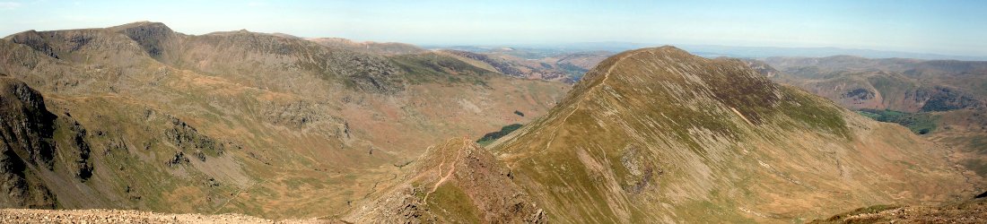
Luckily things were about to change. Shortly after we moved off again, we reached the anticipated flatter section as we crested the high point on the route to La Comparticion, and the view opened out. To the right, a forested peak rose high beyond what appeared to be a substantial drop. Beyond its left shoulder, two more peaks rose higher still a few miles away. These had to be our three summits. The distant two were Pico Duarte and La Pelona. We would be climbing these tomorrow. Meanwhile today’s peak, La Rusilla, still looked a long way off. On the plus side, as the trail descended gently through sparser woodland, I discovered that I still had heaps of energy on the downhill sections.

We reached the next resting point at Aguita Fria (2,650m) just before one o’clock. It was located in a more picturesque setting than previous stops, on a wooded plain with long views out over forest. We sat underneath the pavilion for a short lunch of saucisson, cheese and crackers. As Roselio rested a short distance away with his horse, the dog came to sit with Edita and me. Until now, I hadn’t seen it eat so much as a crumb. Its tongue was hanging from its mouth as it breathed in heavy gasps. Why it had followed us such a ludicrous distance when we’d given it no attention, I couldn’t fathom. Edita took pity on it, and threw it a few splinters of crackers and cheese. I pleaded with her not to give it our prized saucisson that we’d been saving for special moments.
After a 20-minute break we continued onwards. Thick forest covered the summit of La Rusilla. We descended for about 50m and the trail started veering to the left, with no sign of a trail branching right towards the summit. Roselio appeared behind us and indicated that we should turn off. He pointed up a grassy bank and I followed faint footmarks to a vague col where he stopped to tie up the horses. We sat on a log beside a tangle of undergrowth as we waited. It was approaching 2pm and there were still 400 vertical metres to the summit. Unless there was a good trail then it would take more than an hour to reach the top.
After ten minutes of waiting, Roselio came over, still leading one of the horses. He pointed behind me, over the log and through the undergrowth.

‘Este es el sendero,’ he said (‘this is the trail’).
I must have looked puzzled.
‘Sí, aquí,’ he said with a grin.
I started laughing. ‘El sendero?’
‘Si, si.’
As John McEnroe used to say, ‘you cannot be serious’. If this was a trail then it was one for flying squirrels. It was no trail for humans, and certainly not one for horses, and yet Roselio was bringing one of them with us. I scrambled onwards in the direction that Roselio had indicated, weaving between trees, up slanting rocks and climbing over fallen logs. I expected any moment to come across a cargo net. The others followed behind me, but if they thought I was going the right way then they were more confident than I was. I realised that if the terrain was going to be like this all the way, then it was going to take us a lot more than two hours.
After 50 metres, I stopped and turned back to Roselio.
‘Sendero como este todo a la cumbre?’ I said in my infantile Spanish.
I wanted to know if the ‘trail’ was like this all the way to the summit and I didn’t know the Spanish for ‘assault course’. I didn’t catch his reply but I understood the gist, which was ‘oh yeah, motherfucker.’
I laughed again.
‘What do you think?’ I said to Edita. ‘If it’s like this all the way then I’m not bothered about going to the summit. We came here to climb the highest, not the third highest.’
I was tired out. It had been a hard enough day without bushwhacking up another 400m. On top of this, we were in the heart of the wet season, when there is a risk of rain later in the afternoon. We decided to turn around.

We threaded our way back down to the col, where Roselio reunited with the other horse and we rejoined the main trail (or more accurately, the only trail). We reached the high point at Descansa Alto de la Vela, a shoulder of hill where the tree cover became more sparse and the trail descended steeply in zigzags. The sun came out as we were descending. The clouds had risen a little higher and we had good views across a forested valley to Pico Duarte.
We reached La Comparticion at 3.15 after exactly eight hours of walking. Twenty minutes after we arrived it started raining, and continued on and off for the rest of the afternoon. La Rusilla disappeared into thick clouds. Had we continued up it then we would have missed the views and suffered a royal soaking.
La Comparticion was something of a disappointment. The camp was composed of three substantial huts in a sloping forest clearing. One of the huts was padlocked and another was the kitchen hut. The remaining hut, our sleeping accommodation, was a gigantic, empty barn. There was no furniture anywhere: no bunks, no tables, not even a single chair. Our bed would be bare floorboards. It reminded me of old school trips when our teachers made us sleep on the floor of a sports hall. Two ill-fitting doors on opposite sides of the building could only be secured with padlocks from the outside. We had to wedge them closed with rocks to stop the dog from coming inside and disturbing us.
On the plus side, and much to my great surprise, we were the only trekkers here and had the entire barn to ourselves. By the time Roselio brought the mattresses and sleeping bags and we changed into dry clothes, we were comfortable enough. Later on he cooked us an excellent meal of rice and chicken roasted over an open fire in the kitchen hut. With no chairs or tables, we ate our dinner standing up. Darkness came quickly, and we turned in for a long night of rest shortly after 7 o’clock.

Day 2 – Pico Duarte ascent
We slept for almost 12 hours – a luxury only ever affordable on remote treks – and woke with the sunlight at 6.30. We got up at 7am. There wasn’t much to pack. Roselio said that it was very safe here and he was not expecting anyone else to arrive. I put everything that we didn’t need for today’s hike into our small blue duffel, padlocked it and left it in the hut next to our mattresses and sleeping bags.
After a hearty breakfast, we left for the summit at the civilised time of 8.15. The sun was high and it was already hot and humid. It looked like it was going to be a marvellous day to reach the roof of Hispaniola. The dog reappeared as we were leaving, and seemed determined to come with us, as Joel had promised. Roselio told us that it lived down at the national park entrance and was known as Casam.
Now that all our supplies for the trek were safely stashed in camp, I expected Roselio to join us on foot today. But I guess if you have a horse then you might as well use it. A short distance out of camp, I looked behind and saw him trotting along merrily once again.
The pines were much smaller here at 2,450m. It felt like we were walking through a newly laid forestry plantation. Gaps to our left revealed tree cover extending all the way to the summit 600m above us. The trail began with a short traverse, but after a few minutes it started rising steeply in zigzags. It wasn’t long before I was sweating profusely, but the trees provided welcome shade. We walked without resting, though paused frequently to gulp down water.

After about an hour and a half we emerged into a clearing on a small plateau. There was a resting point signposted as Cruce Pico Duarte-La Pelona (2,950m), appropriately enough – we were now on the saddle between the Dominican Republic’s two highest peaks. We stopped for snacks and a short rest before the final heave to the summit. I had already drunk a litre; but we now had the majority of the ascent behind us, so I wasn’t concerned about running out. Across a field of tall grass we could see the modest summit dome of Pico Duarte carpeted in pines. The sister summit of La Pelona was further away to our right. It rose more gently and was also bedecked in forest. Its name translates as ‘The Bald’, supposedly because there are no trees on top. The name was originally applied to both peaks, which were known as Pelona Grande and Pelona Chica, before the higher was renamed in honour of the founder of the Dominican Republic. Unlike myself, the peaks are bald no longer.
Roselio said that it would take just treinta minutos to reach the summit. The final section was easy. The forest thinned, allowing glimpses of the surrounding terrain below us. There were a couple of rocky outcrops to walk under. Then, abruptly, our way was barred by a large boulder. A sign in front of it read:
Bienvenidos. Pico Duarte la cumbre de las Antillas
Over my right shoulder, at the top of another rocky outcrop, I could see a cast-iron statue and a flag pole bearing the Dominican flag. A short scramble led up to the summit of ‘Las Antilles’ (a.k.a. the Caribbean). It was 10.30 and as Roselio had predicted, it had taken just 30 minutes from the saddle. The statue was a bust of Juan Pablo Duarte mounted on a stone cairn. The cairn was cemented awkwardly to the pinnacle of the outcrop, looking like it might topple into a crack at the slightest tremor.

We stayed on top for 15 minutes, had some snacks and posed for summit photos. Edita even posed with Casam the dog, whose name had morphed into Kasim. By the end of the trek we would be calling him Karim, after the first Dominican to climb Everest. He had proved himself a true mountaineer and we were beginning to admire rather than tolerate his presence. But we were all ruffians beside the father of the republic. Juan Pablo was smartly dressed in shirt, waistcoat, jacket and bow tie. His hair was neatly combed back and he sported a fine handlebar moustache. He remained aloof as I posed with my arm around his shoulder.
There was a fantastic view across to the broader, more rounded summit of La Pelona. Left of it, the lower peaks of the Cordillera Central, DR’s principal mountain range, spread out before us in a series of connecting ridges. All were forested, though there appeared to be sparser patches in several places. If there were trails as good as those we had climbed over the last couple of days, then it would be a great place to come trekking. On the other hand, if the trails were like those we encountered on La Rusilla then it would be more awkward. Joel had told us that sometimes a machete is needed.
The precise altitude of Pico Duarte is published variously as 3,075m, 3,101m and 3,175m, depending on which source you consult. The OS Locate app on my Android phone preferred the lower reading. It honed in on 3,071m. But the Travel Altimeter app on Edita’s iPhone was more generous, settling on 3,104m, closer to the middle reading. Naturally, I prefer to go with this one.
It took us just 20 minutes to descend back to the resting point on the saddle, where we stopped for a pineapple that Roselio produced from one of his saddlebags.

La Pelona was a little more distant than Pico Duarte. We traversed across open slopes to reach a substantial hut known as Valle de Lilis. The hut appeared to be brand new and stood proudly in the sun, with wide views spreading out before it. It would be a much nicer setting to stay than La Comparticion. But it was deserted. Roselio said that no one ever used it because there was no water source nearby.
Beyond the hut we re-entered the forest and began the climb to La Pelona. The slope was gentler than it had been up to Pico Duarte and a fine mist descended to shield us from the sun. The trail did not go all the way to the summit, however; it skirted the left side. At the moment when it felt like we were about to descend, Roselio gave a shout. He pointed into the tall grassland to our right. There was no path. Threading between widely dispersed infant pines, I made my way towards a watchtower some 100m away that looked like it marked the summit. The tower was old and rickety. When I got closer I could see that it had no platform and its steps ended in mid air. Several steps were missing. It was a lookout for lemmings; if I had considered climbing it then I banished the idea.
Beside the tower there was a large rock with a flat top that formed a raised platform above the grassland. A metal plate with an inscription was embedded its surface. I bent down to read it:
Servicio Geodesico Inter-Americano, Pelona, 1961
In another part of the rock there was a more modern plate, similarly inscribed:
RLDA Surveying & Mapping GPS Survey Mark, Pelona, Station Designation, 2001
The plates weren’t as arresting as a flagpole and a bust of Juan Pablo Duarte, but their purpose was equally clear. We were standing atop the second highest point in the Caribbean. This summit was far less distinctive than Pico Duarte’s. We were on a broad plateau obscured by sparse tree cover. Even without the thin mist we had climbed into, we would not have been able to see Pico Duarte (or anything else) from here.

It was midday and we stopped for more snacks. My OS Locate app was now saying we were higher than we had been on Pico Duarte, at 3,072m. Meanwhile, Edita’s Travel Altimeter was giving me even more reason to trust it. It settled at 3,096m, lower than Pico Duarte and very close to La Pelona’s published altitude of 3,095m.
We stayed on the summit for 20 minutes, then descended back to Valle de Lilis. We traversed across to the resting point and descended back into the forest. Instead of keeping to the trail, Edita made several diversions down narrow wooded trails. Karim followed her. She thought she was taking shortcuts, but she often returned to the trail behind me.
We arrived back at La Comparticion at 2pm. As Roselio had predicted, there was no one else there. We passed the remainder of the afternoon in the comfort of our spacious barn, leaning our mattresses against the wall. It was after 7pm and I was thinking of turning in for some sleep when the evening took an unexpected turn. The two full-time wardens at La Comparticion had made a camp fire in the middle of a covered outdoor seating area. Roselio called us for dinner and five of us sat around making conversation as we tucked into his delicious meal.

They spoke only a few words of English, but Edita did an impressive job of keeping the conversation flowing using a mix of pidgin Spanish and Italian. I said very little, chipping in only when I could remember a word that she couldn’t. I like to think this had the effect of making me look like a wise old seer injecting pearls of wisdom.
One of the wardens was extremely talkative. He told us that he spends eight weeks at a time up at La Comparticion, then takes an eight-week break in La Cienaga, when he would sometimes work as a guide. He said that the main trekking season lasts for three months, from December to February. On an average day, 50 or 60 people sleep on the floor in the main hut, but he said there was one occasion during the COVID pandemic when there were 500. This seemed hard to believe; it would have been an unbearable night and made Everest 2021 look like an exemplary case of social distancing. We somehow understood that it was because there had been no COVID restrictions imposed on Pico Duarte, so it was a place where people were permitted to mix and have fun during those strange times.
We learned that around 150 guides work on Pico Duarte, and they all ride horses like Roselio (by which I mean the guides are like Roselio, not the horses).
‘Pico Duarte en caballo es fácil.’ Edita said (‘Pico Duarte on horseback is easy’).
Roselio looked nonplussed, but the rest of us roared with laughter.
‘La noche es joven’ (‘the night is young’) Roselio said when I departed for rest at 9.30. It may have been for them, but polite as they were, they turned off the music soon after we departed, and we enjoyed a peaceful sleep.

Day 3 – La Comparticion to La Cienaga
It was another civilised wake up at 7am. We packed up in leisurely fashion, had breakfast and left for La Cienaga at 8.30.
We started with a long climb from 2,450m all the way up to 2,750m beyond the resting point of Aguita Fria. It was a pleasant section of trail with views out over the forest. As we passed the place where we had branched up La Rusilla two days earlier, I pondered our itinerary. Could we have climbed the DR’s third highest peak after all? If you want to climb all three peaks in three days then a better itinerary would be to climb La Rusilla on the third day, when you’re faced with a descent. It would be a long descent of nearly 2,000m, but it would be much easier than doing it in the other direction. Better still would be a 4-day itinerary with an extra night at La Comparticion. The spare day can be used for a full traverse of La Rusilla.
We reached the highest point at 10am. It took us another 3½ hours to descend to La Cienaga. We went at a good rate to spare our knees, frequently running on the steeper sections. The dog Karim appeared to enjoy these bits, though he struggled to keep up. From finding him a nuisance to start with, we had become more attached to him. He had a good temperament, never barking or begging, just patiently waiting for us to give him a snack or make our next move.

We caught glimpses of La Cienaga nestling in the valley far below. We stopped for our only real rest at Altos de la Laguna (1,980m) shortly before midday. Here we had some snacks, refilled our water bottles, and Edita handed Karim our last piece of saucisson. It was the only time we saw Roselio on the whole descent, though he was probably keeping his eye on us all the way down.
The sunken holloways became like chicanes. We plunged down the steeper ones as fast as gravity could carry us. We arrived, tired out, at the park gate at 1.30. Karim the dog lay down on the concrete floor as we waited for Roselio to arrive with our bags. I don’t know how many summits of Pico Duarte he has under his collar, but we were happy with our first. It had been a decent, strenuous three-day hike, much more than just a tick in the box. We would be leaving with happy memories.
You can see all photos from our ascent in my Dominican Republic Flickr album.


