
It’s been a very dry April. For three weeks it barely rained and there are still parts of our garden that I haven’t needed to mow. When the Easter holiday weekend came, however, it was set to tank down. In what seems like an increasingly lawless world, it was comforting to see that British weather still obeys Sod’s Law.
Luckily, there was forecast to be one day of glorious weather on the Sunday, so I nabbed it to take a day trip to the Brecon Beacons, a range of hills in South Wales a couple of hours from our home in the Cotswolds.
Before I go any further I should point out that we’re not supposed to call them by their anglicised name of ‘Brecon Beacons’ any more, but by their Welsh name Bannau Brycheiniog, pronounced Ban-Now Brick-Hay-Knee-Og, and meaning ‘the mountains of Brychan’s place’. Brychan was a 5th century Welsh king after whom the town of Brecon is named.

The name Bannau Brycheiniog has been around for centuries (you can read all about its literary heritage in this article in The Conversation), but it’s not altogether clear which hills the name applied to. Bannau Brycheiniog National Park (formerly the Brecon Beacons National Park) spans three separate ranges: from west to east the Mynydd Du, the Central Brecon Beacons, and the Black Mountains. There is a peak called Fan Brycheiniog in the Mynydd Du, and the escarpment that Fan Brycheiniog lies on was sometimes also known as Bannau Brycheiniog. Now the name Bannau Brycheiniog refers to a much larger area.
This may all sound a bit confusing, but when announcing the name change in 2023 the national park authorities were keen to point out that the English name was misleading because there was never any evidence that anyone actually lit beacons from the mountaintops. I’m aware that it also used to annoy some mountain guides if you shortened the name of the park to ‘The Brecons’ rather than ‘The Beacons’. Unfortunately for these guides, I still know people who call them the Brecons even now.
One of the problems is that it’s never easy adopting a new name. Most guidebooks still bear the old one, and I have to admit that I feel a bit self-conscious saying the new one out loud. It feels a bit pretentious, like calling a Fruit Pastille a fruit past-eel, to rhyme with Bastille (which I understand is supposed to be the correct pronunciation). Most people are unaware the mountains have changed their name. If I tell anyone I’m going to Bannau Brycheiniog I’m either greeted with blank stares or – worse – fashion advice (‘wear the fox hat’).
It was certainly a brave decision for the tourist authorities to change the name from something quite easy to a tongue twister. I don’t know if research has ever been done into the effect on tourism of visitors not knowing how to pronounce the thing they’re visiting. Rumour has it that Jeff Bezos has already ruled out Uranus as a destination for Blue Origin. Another problem with the name Brycheiniog is that it’s hard to fit on the cover of a guidebook, a problem well known to Finnish publishers.

Anyway, some of you are probably thinking I’m milking the subject a bit and wishing I’d get on with the trip report, so I will.
I decided to climb Pen y Fan (886m), the highest peak in the Whatnot Hills. I’ve climbed it four times previously, but only ever as a horseshoe from the Neuadd Reservoir on the south side (twice), or via one of the parallel ridges leading up from Brecon (yes, you’re still allowed to call the town on the north side Brecon). I wrote about these two outings in 2011 and 2018 here in the blog. On the latter occasion there was even an earthquake 20 miles away during our ascent, but (story of my life) I didn’t notice it happening.
I had never climbed Pen y Fan via the main tourist trail on the west side. This is a direct, landscaped path straight up a hillside to the summit from a big car park on the A470, just south of the Storey Arms Outdoor Education Centre. It’s considerably easier and more accessible than any of the routes I’ve taken previously, so I decided to stick a diversion onto it to spice things up a bit.
Around 6km north of Pen y Fan, the Bannau Brycheiniog National Park Visitor Centre is tucked away up a back road in a quiet area of open moorland. By parking there I would be able to give myself a slightly longer walk over a smaller peak, Fan Frynych (629m) and along the escarpment edge of Craig Cerrig Gleisiad (whose high point is also 629m) to reach the main car park. The extra peak would provide a good warm up, and by the time I reached the foot of the tourist route, I was likely to be well acclimatised for the higher altitudes.
The car park was empty when I pulled up at 9am. The visitor centre didn’t open until 9.30, but there was no barrier, so I was able to enter and pay my £3 fee to park there for the day (by contrast, I noticed that the main car park beneath the tourist route is £7.50). There was a slight chill in the air, and a layer of thin clouds hung over the twin summits of Pen y Fan and Corn Du to the south-east.

I took a cattle track alongside a hedge on the fringes of open moorland. The grass was a lush emerald green and the gorse was alive with yellow flowers. Pen y Fan seemed a long way off to my left, but my OS app told me that the circular route I had plotted would take 7½ hours to complete, so I assumed it was nearer than it looked. More concerning was that I appeared to be going in the wrong direction. I was walking away from Pen y Fan towards Fan Frynych, which rose ahead of me in the form of a long grassy ridge.
My route crossed a large but peaceful campsite on a sloping field with a fine view of the mountains, to climb Fan Frynych directly by its north-east ridge. There was a good trail all the way up and the sky brightened as I climbed. I reached the top about an hour after setting out. A whitewashed Ordnance Survey trig point marked the summit beside a small pool atop a grassy plateau. I had seen only one other walker and I felt like I was the only person for miles around.
The view to the west had something of a wilderness feel, across acres of rolling grassland to the Mynydd Du on the far horizon, with not a single road or habitation interrupting the emptiness. I knew that the madness and mayhem of Pen y Fan’s main car park and tourist route was just a short distance away, but here on top of Fan Frynych it felt so peaceful.
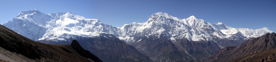
The clouds were beginning to disperse from the tops of Pen y Fan and Corn Du, and by the time I reached the col between Fan Frynych and Craig Cerrig Gleisiad, the sky was completely clear. The twin summits were very distinctive, rising above the A470 like the wheelhouse and funnel of a ship.

From the col I followed the curving rim of a steep cliff, Craig Cerrig Gleisiad. My path followed the right-hand edge of a dry stone wall. I had been alone for most of the first hour, but as I approached the top I saw several groups coming the other way on a trail the other side of the wall. I wondered if I had taken the wrong gate, but my path turned right across moorland to approach the Storey Arms from above. Vehicles raced past on the A470 below me and the roofs of hundreds of parked cars sparkled in the sun. The main car park looked full already, and cars were parked all along the sides of the road. It was an abrupt contrast to the solitude of Fan Frynych that I’d crossed just half an hour earlier.
The two large white-washed buildings of the Storey Arms nestled beneath a plantation of pine trees at the foot of Pen y Fan. A busy trail climbed directly from the buildings up the hillside to the left of the trees. This trail followed the Cambrian Way across moorland to approach Corn Du from the north-west. My target was the main trail, however, which I could see slanting more gently across the face of Tyle Brith from the main car park to the the right of the plantation.
I descended to the road to join the masses, crossed over and passed through a gate onto a dirt track that followed the edge of the plantation to the main car park. The sun was shining brightly as I crossed the car park to the gate at the top end.
I now found myself on a trail with hundreds of other people. They came in all shapes and sizes, and dressed in attire you would not normally expect to see on a hill: jeans and fashionable trainers, pink tracksuits and leggings in every conceivable colour. Most were young, including many small children, some of whom struggled gamely with one hand clasped in their parent’s, others carried on shoulders. One man even carried his dog. The trail was dead straight and firm underfoot. The lower peak of Corn Du could clearly be seen all the way up, its summit cut flat as though by a giant hacksaw and rising like a stage on the horizon.

Faced with such crowds there was only one thing for it: to shoot past them and continue without stopping. I decided to time myself, not as a challenge but out of curiosity. I was surprised to discover that it took me precisely 44 minutes from the gate at the top end of the car park to the summit cairn of Pen y Fan. I bypassed the summit of Corn Du because I knew I would return there on the way back. I wasn’t racing, just walking at a steady pace that I knew I could maintain indefinitely; but I didn’t stop, either for a water break or to remove a layer, only for half a dozen clicks of a camera.
I’m not stating this time to brag, but simply to give an indication of my usual (brisk) walking pace. I know that many of you reading this could do it more quickly; those of you who are runners quite easily. In 1992 James Ward of Derby ran up in 22 minutes 20 seconds, just one second ahead of Keith Anderson of Ambleside, who then proceeded to run back down in 7 minutes 39 seconds, thus completing the whole route up and down Pen y Fan in exactly 30 minutes. The mind boggles.
The ascent flattened out at the awkwardly named Bwlch Duwynt, about 60m below the summit of Corn Du. Although it sounds like the noise you might make when you’re trying to attract someone’s attention, the word ‘bwlch’ means ‘col’ in Welsh. This particular col divides Corn Du from Craig Fan Ddu, the western ridge of Cwm Neuadd, Pen y Fan’s great southern basin that lay below me to my right. The summit of Pen y Fan rose just 500m away at the end of a red sandstone path that skirted the northern edge of the combe beneath the summit of Corn Du.
After pointing my camera back down the path, at Fan Frynych across the valley behind it, and then at Corn Du, I continued onwards along this path to the highest point in South Wales. I had another surprise when I reached Pen y Fan’s broad summit plateau. A flattened cone about 10m across has been built at the highest point, and a small plaque has been erected to mark the summit. I counted around 70 people queuing to have their photographs taken beside the plaque.

It’s only the second time I’ve encountered this phenomenon of queuing for a summit photo, the other being the last time I climbed Snowdon, when I didn’t realise the significance of the queue and somebody gave me a bollocking after I walked past it to take my photo. I’m not quite sure what to make of it. If there are only two or three people on the summit, then it’s only polite to move out of the way to let others have their photo, but when there are this many people then part of me thinks it’s much better just to have a free for all. In the time it takes for the people at the back to have their turn, Keith Anderson could have run up and down the mountain twice.
It was just after midday. I took a selfie about 5m away from the cairn with the queue and posers behind me and WhatsApped it to Edita, who was in Haiti just waking up. Then I found a patch of grass above Cwm Neuadd and sat down to have my summit beer and sandwiches.
The line of summits that form the central peaks of Bannau Brycheiniog – Corn Du, Pen y Fan, Cribyn and um… Fan y Big – can accurately be described as an escarpment. The land rises more gently on the grassy slopes of the southern side, then falls away in steep cliffs to the north.

While the southern side forms a single large combe, Cwm Neuadd, which I looked into as I ate my lunch, the northern side is composed of five parallel ridges enclosing four smaller combes. The western-most ridge, which descends from the summit of Corn Du, was my route of descent. I crossed the col and completed the 5-minute walk from Pen y Fan to its sister summit, where the queue for photos on the summit cairn was only three people.
I took my selfie and dropped down the ridge, past another man carrying his dog in his arms like a laundry basket. The western ridge was another grassy escarpment with steep slopes falling away into Cwm Llwch to my right. Beyond the combe, the land was flat as far as my eyes could see.
Within minutes I was away from the crowds again and descending alone. I passed a small obelisk and paused to read a sad story carved in stone. The stone was a memorial to Tommy Jones, a 5-year-old child who got lost on the mountain in 1900 and whose body was found in this lonely location after he had been missing for 29 days.
Towards the bottom of the ridge the town of Brecon came into view, and there was a fine view behind me, looking back up Cwm Llwch to the two summits I had just ascended. Corn Du looked like a more distinctive summit, a prominent trapezium looking just like a summit should look with sudden drops on both sides. Pen y Fan’s summit was more like the high point at the end of a gentle incline. It looked lower.

I enjoyed one last look before passing through a corridor of gorse, around a shoulder of hillside, across a boggy field and down into the lowlands. The last part of the walk took me along country lanes enclosed by tall hedges. I stopped at a bench in the oddly name village of Tai’r-Bull. Pen y Fan was far away again; I looked back up at it as I rehydrated in the sun. I had been walking briskly all day and was out of breath. There was one more climb back up a track to the visitor centre, which I reached soon after 3pm.
It had taken me less than six hours, but had been one of my favourite ascents. More intrepid walkers could probably extend the walk by continuing along the escarpment to Cribyn or even Fan y Big and dropping down one of the eastern ridges to complete a larger loop.
You can find links to my route map at the end of this post. The route was recorded as I climbed, so don’t follow it too closely or you will not only find yourself wandering off to my lunch spot on the side of the hill, but also to the place where I left the trail to take a pee behind a gorse bush.
It remains for me to end the post with this uplifting video by local actor Michael Sheen, which will surely inspire even the most sedentary lazybones to rise from their chair and explore Bannau Brycheiniog.
Route map
Total distance: 23.05km. Total ascent/descent: 1,007m.
View route map and download GPX


I think the oddly named village was actually Libanus. Tai’r-Bull Is the name of the pub I think. I regularly run to the top of Fan Frynych from home – a lovely peaceful summit. It will always be the Brecon Beacons to me. Have enjoyed your blog since reading your book many years ago.
Always a good read and love the photos.