
It was the early May bank holiday, and although the weather wasn’t perfect, it was good enough to head for the Lake District for some hill walking.
Choosing a route can often take an hour or two of browsing maps and guidebooks, but this time I didn’t have to do any of that. After taking Edita up Scafell Pike, the highest peak in England, last year, it was a no-brainer to introduce her to a UK hill-walking classic: Helvellyn via Striding Edge.

I described an early adventure on this route in my book Seven Steps from Snowdon to Everest, which involved a humiliating retreat and ascent of the much easier Swirral Edge route.
The knife-edge ridge scramble of Striding Edge had been an evocative destination to me after learning about it in school geography lessons. In the ice age, glaciers carved out the combe beneath Helvellyn in which the lake of Red Tarn now nestles. Meanwhile a glacier on the other side carved out the U-shaped valley of Grisedale, leaving behind the knife edge of Striding Edge.
I eventually climbed Helvellyn via Striding Edge in my early 20s with some fellow students while studying for my masters degree at Loughborough University. It was somewhat cloudy and windy that day, and I remember having to crouch low along the crest to keep my balance every time there was a gust. Although I’ve been back to Helvellyn since then, it remained my only ascent via Striding Edge.
It was cloudy on the Sunday of the bank holiday weekend, but it was clear on the hilltops and we would have views. We made a late start at 10.30 after queueing ages at the car park in Glenridding. We were all paying the £8 fee by credit card, and the internet connection was the speed of a laden tortoise.
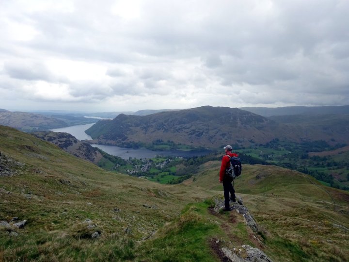
There were already hundreds of people on the trail up Mires Beck as we made our way through Gillside campsite. We sped past them without pausing, and soon arrived on a shoulder of moorland looking out over Ullswater. It was time to pause and look back at the silver lake snuggling between bare hillsides. Many people were sitting on the staircase of stone steps beneath us, admiring the view.
The trail climbed steeply up grassy slopes to reach the high plateau of Birkhouse Moor. Here it flattened out for a kilometre as we found ourselves walking towards Helvellyn’s high eastern combe. More and more of it was revealed as we approached.
The flat top of Helvellyn was straight ahead, and the armchair combe was flanked on one side by Striding Edge. From here it looks more like a whaleback hillside whose summit is High Spying How, the high point on the ridge.
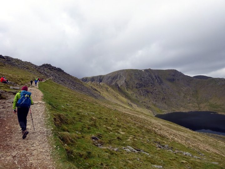
The northern arm of the combe was blocked by the outlying peak of Catstye Cam, and somewhere in the bowl was Red Tarn, but we couldn’t see it yet.
Beyond Hole-in-the-Wall, a gap in one of the dry-stone walls that scar the moors east of Helvellyn, the path diverged. As we continued onwards, Red Tarn appeared in the combe beneath us. A clear trail went anticlockwise around the tarn to join the northern ridge of Swirral Edge.

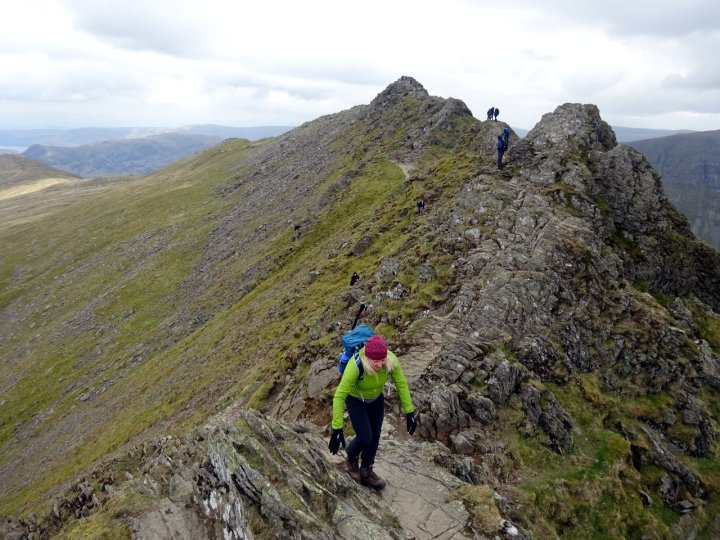
We continued onwards to join the crest of the ridge ahead of us: Striding Edge. We stopped to put away our trekking poles, which we wouldn’t be needing as we scrambled along the ridge, and found ourselves among the crowds.
Four years ago I introduced Edita to another of Britain’s classic ridge scrambles, Crib Goch on Snowdon. This is a ridge I am more familiar with, having scrambled along it a few times more recently than my visit to Striding Edge 23 years ago.
Memory is not so reliable over that period of time. Not only was Striding Edge less busy today than Crib Goch was four years ago, but I was surprised to find it much broader than I remembered. There are places on Crib Goch where it’s impossible to pass others, and more nervous types are inclined to straddle the ridge like a horse.
By contrast, it would require contortions and challenge the trouser fabric to straddle Striding Edge. There were many places to pass other walkers, including a wide, easy path a few metres below the right side of the crest.

I think we were both underwhelmed, but I managed to hide it better than Edita.
‘So where’s the knife edge?’ I heard her mutter behind me.
I laughed.
‘This is it, but I can see you’re not impressed. Actually, it looks much easier than I remembered it.’
In fairness to Striding Edge, it did get narrower. In the early stages we followed closely behind a young couple from the north of England. After one particularly ungainly manoeuvre, the woman looked behind her and made a general remark to the wind.
‘I’d like to apologise to the folk behind me. I know me aarse is ‘anging out o’ me leggins.’
By which she meant that her trousers were slipping down.
As she hitched them up I reassured her that I had been concentrating my attention on other cracks, and hadn’t noticed. I then had to stop and explain to a stunned Edita that this young lady wasn’t being particularly brazen — she was just from the north of England, and this is the way people talk up there (although I live in London, I was born and raised in Yorkshire, so I feel able to say this with impunity).
We spared further embarrassment by slipping past them at a wider section. Beyond it the ridge narrowed to the knife edge that Edita had been hoping for, and although a wide path snaked along to the right, we kept to the crest, striding confidently with our heads held high.
Not everyone was feeling so bold. We passed a young lad of 16 literally crawling on his hands and knees.
‘Why the bloody ‘ell didn’t I go that way?” he said, looking wistfully at the broad path a few metres below.

I felt for him. In my teens, I also had a terrible head for heights and would have found Striding Edge a little frightening. But confidence comes with experience, and over the years my head for heights has improved to such an extent that Striding Edge presented no difficulty at all.
The trickiest part of Striding Edge comes right at the end, when you have to scramble down the final rock tower. I overtook someone along this section, and after lowering myself down, he was surprised when I looked behind me and offered my hand to help him down.
I was just as surprised when we caught each other’s gaze. I quickly withdrew my hand.
‘Ah, I’m sorry. I thought you were my wife.’
Edita was waiting behind him, and I could see her laughing.
He was more serious.
‘You can help me if you want,’ he said.

With Striding Edge behind us, we had a final scramble up slabs before a steep path led up to the top of Helvellyn.
The summit of England’s third highest mountain is a giant plateau of a ridge with a steep escarpment on its east side looking out over Red Tarn. There are several summit cairns. The highest is the one right on the edge, on a semi-promontory just before the Ordnance Survey trig point.
There were lots of people up there, so we took our summit photos and moved on. The next part of our walk was blissful as we walked south along a broad grassy crest. These wide ridges are some of my favourite features of the Lake District.
There was a roof-of-the-world feel with most of Cumbria’s main peaks in view. The Scafell Pike massif was on the horizon to our right, the flat skyline of High Street to the left, and the silver sliver of Windermere in front.

Our ridge crossed over several summits — Nethermost Pike, High Crag and Dollywaggon Pike. We stopped at the last of these for some lunch, and sat on a grassy cushion looking across to our next objective, Fairfield.
Beyond Dollywaggon Pike, the path dropped 300m to Grisedale Tarn. This was a beautiful, peaceful spot. A navy blue pool nestled in an enclosed combe-cum-col (which sounds rude, but is a word we should all try to use more often).
We circled the lake clockwise, and then had to regain all the height we’d lost to reach the summit of Fairfield. I felt like I was plodding slowly, but we must have had hill walker’s legs from our visit to the Apennines two weeks earlier. We overtook a few more people and reached the top at 4pm.

Rarely can a mountain have been less aptly named than Fairfield. Its summit is something of a barren wasteland — another big plateau of stones and cobbles. If you played a football match on this surface, you might be forgiven if you ended it thinking you’d been marked by Vinnie Jones for 90 minutes.
On the plus side, it is centrally located in the heart of the Lake District, which means it commands a huge vista, not only of most of Cumbria’s peaks, but of the more distant Pennines to the east.
We had another snack on the summit as we eyed up the final section of our walk. The last part of the horseshoe dropped down into the col of Deepdale Hause then up and over the summit of St Sunday Crag. It was a gentle ascent, commanding great views across the valley of Grisedale to Helvellyn and Striding Edge.

There was a pleasant end to the walk as we dropped down into the emerald paradise of Patterdale embracing the shores of Ullswater. There was a last short climb over a moorland shoulder and past the peaceful dell of Lanty’s Tarn to get back to Glenridding.
We arrived in the car park bang on 6pm, after a 7½-hour walk involving 1,550m of ascent and 19km of distance. I knew these last few details from the Ordnance Survey smartphone app, which had used a formula known as Naismith’s Law to predict that the horseshoe would take 6 hours 23 minutes to complete.
Back in 1892, a Scottish mountaineer called Willie Naismith invented a simple formula for calculating the length of walks: one hour for every 3 miles (5km) of distance, plus one hour for every 2,000ft (600m) of ascent.

The formula doesn’t take account of lunch stops, but we had stopped 3 times. If these stops took an hour in total, then in our case Naismith was fairly accurate. Whether the same could be said for the dozens of people we overtook I’m not so sure.
More certain is that we’d had a great day out, even if the knife edge could have done with some sharpening. I can’t believe it was 23 years since I last climbed Striding Edge.
As they say in the north of England, it was about blooody time I went back.


Walked Striding Edge about 14 years ago on NewYear’s Day, it was covered in ice and snow, very pleased I had my crampons on! It was bit hairy in places but a great walk! At the top I rang my girlfriend who was spending Xmas in Melbourne Oz. Good memories!!
Pingback:Ben Nevis (2014) – Katrina Hemingway