
In the Kilimanjaro chapter of Seven Steps from Snowdon to Everest, about my journey from hill walker to Everest climber, I described the Shira Route, that I used on my first ascent of Kilimanjaro, as the Stagnant Water Route. There is plenty of variety on the flanks of Africa’s highest mountain, but the dirt track I took up to the Shira Plateau on the west side of the mountain, was distinctly uninspiring, and I promised myself that if I ever returned to Kilimanjaro I would find a more interesting way up.
As it is for many people who climb Kilimanjaro, it was all about the summit the first time. I really enjoyed the whole experience, but the fact that I made it to the top was the most important thing.

Fourteen years later the situation was very different. Having climbed many more challenging peaks than Kilimanjaro, reaching the summit wasn’t really an issue. Exploring a bit more of the mountain and basking in the experience was the goal.
I wanted to climb a more interesting route, but in particular I wanted to spend a night on the crater and explore it thoroughly. In this respect, the climb exceeded my expectations and more. In fact, I would go so far as to say that 99% of people who climb Kilimanjaro, perhaps an even higher proportion than this, don’t even get to see its best bit. Without a doubt the highlight of Africa’s highest mountain, the jewel in its crown, is its inner crater and ash pit.
I had no idea what it looked like until now. Most people walk around the outer crater rim, and don’t even realise it’s there. Neither did I. The inner crater actually lies inside a small, rounded hill within the outer crater. You have to climb the hill in order to look down into it. This hill is almost as high as Uhuru Peak, Kilimanjaro’s highest summit on the rim of the outer crater. I actually mistook it for the opposite rim of the crater, and I’m sure many other trekkers do.
Now I know better, and when I climbed that hill it took my breath away. But more about that later.
We chose to climb Kilimanjaro by the Rongai Route, the only trail in from the north side, from the Kenyan border, and one of the quietest on the mountain. We would descend by the Marangu Route on the east side, conversely Kilimanjaro’s most popular trail, also known by the unfairly disparaging name of the Coca Cola Route. This would give us the opportunity to explore Kilimanjaro’s west side, which I didn’t see at all on my previous visit.
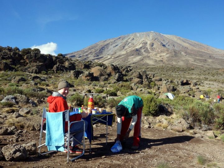
We used a local Tanzanian operator, Zara Tours, to arrange the logistics for our climb. Based in Moshi, they are quite a large operator with their own hotel, the Springlands, on the edge of town. As well as treks up Kilimanjaro and Mount Meru, they arrange safari tours all over Tanzania. We were impressed by their set up. The Springlands was a peaceful and relaxing place to spend downtime between Meru and Kilimanjaro, with a secluded garden, restaurant and hire shop if you need any last minute equipment.
Our guide for Meru and Kilimanjaro, Joseph, had over 20 years’ trekking experience, working his way up from porter, through kitchen assistant, cook and assistant guide to head guide. He told us he had climbed Kilimanjaro over 500 times, but at 30 trips a year for more than 20 years, we decided this was likely to be an underestimate. We were probably a bit more demanding than the average client, with our own ideas about the itinerary and how the mountain should be climbed, but throughout the trip Joseph remained cheerful, patient and flexible, and this trait contributed to the success and enjoyment of our trip. I would certainly recommend Zara Tours to anyone looking for a bespoke itinerary.

There was a slightly strange beginning to the trip, though. While our porters were getting ready with their loads we were put in the hands of a guide from another operator for the first section of the trail from the Rongai Gate (2000m) to Simba Camp (2600m). He had two clients of his own who appeared to be trekking to high altitude for the first time. Unlike ourselves, they had not pre-acclimatised on Mount Meru.
For the sake of his own clients he was quite right to start off slowly, but for us the pace meant that we risked falling asleep in mid-stride. The conversation only made things worse. Keen for peace and solitude, we dropped behind them to walk on our own.
“What’s the highest you’ve ever climbed?” we heard him say to his clients.
“Not very high. Only about 3000m,” one of them replied.
“I hope he doesn’t ask us the same question,” said Edita.
But perhaps he thought we were feeling left out. After interrogating his own clients for a few minutes, he dropped back to talk to us.
“What’s the highest mountain you’ve ever climbed?” he asked Edita.
Without answering the question, Edita accelerated past the other two clients, leaving me to answer.
“Er … well, we’ve both been here before,” I said.
“To Kilimanjaro? Wow, did you reach the summit?”
“Er … yes, we both reached the summit.”
“You reached the summit? Wow!”
I looked up, and noticed that Edita had sped past the other clients and was catching up with some porters fifty metres further up the trail.
“Is that Rongai down there?” I said, pointing back down the trail.
The guide looked behind us, and I took the opportunity to slip away and catch up with Edita.
“Mr Mark, Edita … pole pole, slow down,” I heard him cry behind us (pole, pole is Swahili for slowly, slowly). I ignored him.
“What was all that about?” I asked Edita, when I caught up with her.
“I don’t know. Why does he have to talk so much, and walk so slowly?” she said. “They’d better not try and make us walk with those guys again. We paid for a private trip.”
But at the speed Edita was walking, the other clients would get altitude sickness for sure. Not only did we have lots of experience at high altitude, we were already acclimatised. We were on the summit of 4566m Mount Meru just the previous day. We never did find out why they tried to join us with another group. They had done the same on Mount Meru, when we travelled with three Czech clients because we believed we were sharing the services of the park ranger. This time it was a bit of a mismatch. Later, we pointed out that we were here to climb at our own pace, to our own itinerary, and happily everything went smoothly from then on.
In fact, it was a blessing in disguise, because once Edita had shot off the front, we were entirely alone and unescorted all the way to Simba Camp. The trail was easy to follow, and although there were one or two side trails, there were enough porters passing by that we were in no danger of getting lost.

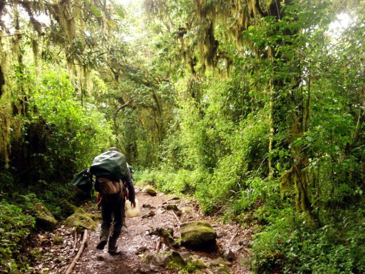
On its southern side Kilimanjaro is known for its thick jungle, but here on the north the forest zone was quite thin. The route starts among cultivated farmland and conifer plantations. Shortly after Edita made her escape we found ourselves walking past potato fields and bamboo huts in a long clearing. The conifer plantations soon gave way to wilder forest with deciduous trees, bracken and yellow proteas, but nowhere was it thick. The trail was very well maintained, gravelled in places, and we were surprised when we stumbled into Simba Camp after only a couple of hours of walking.
It was a very busy clearing in the forest with a small hut, several picnic tables and a toilet block. We were one of the first groups to arrive, but before long every square inch of grass was covered with tents. One of the advantages of camping on the crater is that you need to bring your own toilet facilities so that you can keep the crater clean and take your waste back down with you. This meant that we were the only people in that busy campsite with our own private toilet tent. Edita was so keen to make use of it that she helped our special toilet porter to erect it, a cheerful Masai who was portering on Kili for the first time.
We were also pleasantly surprised at the size of the two-person tent that Zara Tours had provided. The porch was as big as the sleeping part.
“Come and look at this,” said Edita. “We’ve got a dance floor!”
But it was even more useful than a dance floor, as we discovered when they brought in a table and two collapsible director’s chairs. The porch wasn’t a dance floor, but a private dining room. The mix-up with the garrulous guide and his two leisurely clients was quickly forgotten.
After our great success at following a clear path, it was agreed that we could walk unescorted the next day too. After breakfast Joseph showed us the start of the trail out of Simba Camp, and Edita and I set off on the next leg of our journey.
We were out of the forest almost immediately, walking through a dense tangle of giant heather, gradually shrinking in size as we climbed higher. It was a clear day, and once the undergrowth became less than shoulder height, we were able to see the dome of Kibo, Kilimanjaro’s main summit, on the horizon ahead of us. It’s snow-laden flanks were marked by brown lines where gullies and couloirs fell down to the plateau below.
We ascended quickly, overtaking many trekkers and porters. Edita led, and I had to walk briskly to keep up. Joseph had been teaching her some words in Swahili, and every time she overtook a porter she said imara kama mbogo, which means strong as a buffalo. It wasn’t clear whether she was telling them she was as strong as a buffalo, or they were, but they seemed to enjoy it, helping her learn until she’d mastered the phrase. As I sweated along behind her trying to keep up, one porter taught me the phrase mrefu kama twiga, which I used a couple of times to great merriment, until Joseph caught up with us and explained that it meant tall as a giraffe.
It took us little more than two hours to reach Second Cave Camp at 3450m, where the dense undergrowth started to give way to sparse moorland. Here the Rongai Route branches into two. The majority of trekkers take a more eastern route up to Mawenzi Tarn Hut, underneath Kilimanjaro’s second peak Mawenzi. While this takes a potentially more interesting route along two sides of a triangle before meeting up with the western branch at Kibo Huts, we were very happy with the shortcut Joseph had chosen via Third Cave Camp, because it was much quieter.
We were now on the gentle plateau that encircles Kibo between 3500m and 4500m. Vegetation was much sparser, but still plentiful, including the startling red bells of the Mackinder’s gladiolus. Third Cave Camp (3950m) was in a beautiful sheltered location beneath cliffs, looking north into Kenya, where the clouds billowed up from the plains.
In contrast to Simba Camp, which had been packed, we were alone here apart from a single Chinese trekker and her crew, who were camped fifty metres away. We spent two nights at Third Cave, and the air was particularly clear. On the first evening the stars were abundant in a way I’ve rarely seen, and Venus shone brightly over Kibo. It was so bright that to begin with we thought there were people on the summit, but they must have been equipped with the most powerful torch beam ever invented.
In the morning the sky was clear, and we took our table and chairs outside to eat breakfast beneath Kibo. Most of yesterday’s snow had melted and Kibo’s tawny dome had just a single streak of ice on its summit.
Edita, Joseph and I spent an acclimatisation day exploring the plateau. We climbed a gentle hill to look up at the black fortress of Mawenzi. Kilimanjaro’s second peak is a jagged mass of rock, very different from the gentle Kibo, and the clouds rising up from below gave it a forbidding air. As the clouds threatened to engulf us too, we climbed higher to the saddle between the two peaks, to get views of Kibo Huts, from where we would start our summit ascent. We were surprised to see buffalo footprints in the sand, here at 4000m. Although we never saw a buffalo, Joseph said he does on most trips.
The following day we climbed above the vegetation through a desert landscape of rocks and sand to Kibo Huts (4700m), the springboard for summit ascents from the east side. It was the first time I had seen the Saddle, the huge featureless plateau between Kibo and Mawenzi, a remarkable desert above the clouds. Apart from glacier ice and snow, there is no water above here, so it has to be carried to Kibo Huts by porters. Here we rejoined trekkers from the eastern branch of the Rongai Route, as well as trekkers on the Marangu Route, so the huts were busy.

We arrived shortly after 11 o’clock and pitched beside the trail above the highest hut. There was a brief look of shock on Joseph’s face when I suggested an acclimatisation hike up to Gillman’s Point later in the afternoon, but he relaxed when he realised I was joking. Gillman’s Point is the place where the steep trail up from Kibo Huts reaches the rim of the outer crater, just 200m lower than the true summit, Uhuru Peak. For many people it’s as far as they get, and the national park authority even issues certificates to people who reach it. Joseph had become accustomed to our unusual itinerary demands, and there was probably a moment when he thought I was being serious.
Edita and I did go for a short hike 200m above the huts later in the afternoon, before returning for tea and biscuits in the dining room, looking up at Kibo. On my summit night 14 years ago I was nervous, but this time we were really looking forward to the next two days that we knew would be the best two days of our trip (and so they proved).
Before settling in for a short night, we were granted one last treat by the mountain gods as the sun set over Kibo, casting the once-black fortress of Mawenzi in a russet glow as we gazed across the Saddle. For the first time since we’d arrived, Kilimanjaro’s sister peak was completely clear, displaying no easy route up its rock buttresses.
We had agreed to leave for the summit at 4am, three or four hours later than everybody else at Kibo Huts. There was no real need to leave any earlier. I wanted photos of our ascent, which meant I needed daylight. On the previous two days we noticed the summit remained clear of clouds till about 11am. If the same thing happened tomorrow then we had a full seven hours to reach the summit.
We were tucked up in our sleeping bags by 8 o’clock, which meant we could get six or seven hours’ sleep. We heard a German trek leader asking his guides to wake his clients at 10.30pm, which seemed absurd. I was inevitably woken by other trekkers leaving for the summit on the trail just outside our tent, but these noises didn’t seem to last for long, and for the remainder of the night all seemed quiet.
In fact, I must have slept well. When our crew came with tea at 3.30am, we were surprised to see a couple of inches of snow on the ground. This made everything more exciting. Joseph, Edita and I left at 4.15. We could see points of light below Gillman’s Point, belonging to those who had left at midnight. Here we had the trail to ourselves. We walked for barely more than an hour in total darkness on the zigzag trail before it became light enough to climb without head torches. At 6am we were treated to a spectacular sunrise behind Mawenzi, something I remember well from my first ascent.
It was light by the time we reached Hans Meyer’s Cave, the halfway point between Kibo Huts and Gillman’s Point. Not long after this the first of our porters caught up with us, on their way to Crater Camp.

We reached Gillman’s Point shortly after 8 o’clock, where we met the first summiteers coming down again.
“You’re nearly there,” one of them said to us, by way of encouragement.
Gillman’s Point is a better viewpoint to arrive on the crater than Stella Point, where the main southern routes emerge. You’re able to see right across the outer crater to the sheer cliffs of Uhuru Peak on the opposite side. From Gillman’s Point it’s about another hour of walking and 200m of ascent, but it’s a very picturesque and encouraging route. We could see our destination all the while as we took a narrow snow-clad trail clockwise beneath the cliffs of the outer crater rim.
Despite this, a great many people coming the other way found it necessary to tell us we were nearly there – in fact, pretty much everybody who wasn’t too exhausted to acknowledge us (which was a surprising number of people, many of whom seemed to be Japanese). Two friendly Indian climbers even stopped Edita to lecture her about how she was so close that she shouldn’t even think of turning around.
It was nice to begin with, but it became a bit tedious. We could see we were nearly there, and we were racing up so fast that it wouldn’t take us long at all. I thought about telling them that we were camping in the crater, and we had a good deal less distance to go than they had, but that seemed cruel. Neither did I tell them that we’d set off four hours later and almost caught up with them. It seemed easier just to humour them and feign exhaustion.
Above Stella Point the crater rim broadened, and we found ourselves walking just a few metres away from the edge of the Southern Icefield. Kilimanjaro’s glaciers appear to sit on the surface like marzipan on a cake, a thin layer of icing that can just be lifted off. They are very picturesque, but sadly they won’t be around much longer – I have disturbing before-and-after photos of the Furtwangler Glacier, which has halved in size since I was there 14 years ago.

We reached Uhuru Peak (5895m), the summit of Africa, at 9.15, exactly five hours after leaving Kibo Huts. Most of the other trekkers had been and gone, and there were only two other people slumped on rocks when we arrived. The sky was still beautifully clear, and we stayed for about 15 minutes eating our snacks and gazing into the outer crater. We could see that our crew had already set up Crater Camp 150m below us. There is a shortcut down into the crater from Stella Point, and while we were approaching Uhuru Peak they must have slipped below and overtaken us.
We continued around the rim for a couple of minutes more until a trail led down into the crater to join up with the Western Breach, one of Kilimanjaro’s less popular routes to the summit. By 10 o’clock we had arrived at what is undoubtedly one of the most unusual campsites I have ever stayed.
We were in a dry, barren valley which felt like the surface of the moon. Our camp was beneath the 150m cliffs of Uhuru Peak, and across the valley (actually the outer crater) was the gentle hill that hid the inner crater. Less than a hundred metres away from us the remains of the Furtwangler Glacier rested on the surface of the sand like a giant ice cube. This was our water source, and our crew collected water not by chipping away at it, but by putting a pan underneath a spout.
We arrived not a moment too soon. Within minutes of our arrival the clouds swept across, and for the next six hours we couldn’t even see the glacier a short distance away. But we didn’t want to waste our time there. When would we be back here in the crater of Kilimanjaro? So at 4pm, Edita, Joseph and I put on our boots and warm clothing, and walked across the sand to the Furtwangler Glacier. Right on cue, the clouds lifted, and there we were, in this moonlike landscape beneath clear blue skies.

We explored the whole northern section of the outer crater that afternoon, crossing the blank spaces from south to north and standing beneath the 50m ice cliffs of the Northern Icefield. It was a secret landscape that only a handful of the 40,000 who climb Kilimanjaro each year see. There were two other parties camped in the crater that day, but none of them came out exploring like we did. Nor did they climb up to the inner crater the following day. They missed out on something rare, and it seemed such a waste.
Joseph took us to the very top of the Western Breach to look down at what is generally regarded as Kilimanjaro’s toughest and most interesting trekking route. It gets its name because there is a large gap in the outer crater rim which the Furtwangler Glacier used to spill down (now it has retreated so much that it no longer reaches the edge). Clouds were billowing up from below and we couldn’t see down, but it was atmospheric to stand there.
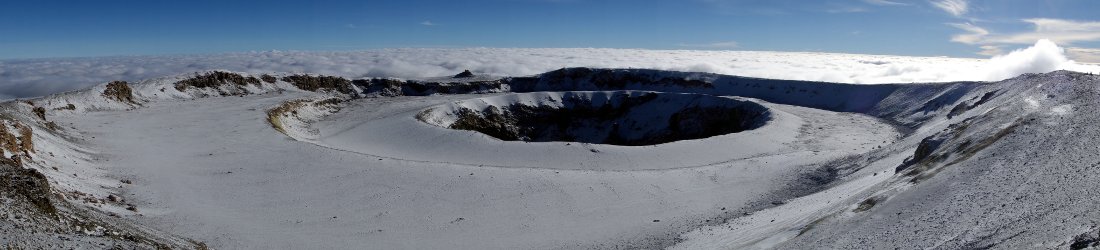
But the best day was yet to come. We got up soon after dawn the following day. The sky was crisp and clear, but we didn’t know how long these conditions would last. There had been another few inches of snow overnight and it felt like we were walking through a layer of fine ash as we strode up the small hill to the inner crater.
I was unprepared for what greeted us at the top of the hill, as a whiff of sulphur hit us. I’ve ascended many volcanoes in my time, but Kilimanjaro has one of the most perfectly concentric craters I have ever seen – a circular rampart, like an old English hill fort, and within it a smaller ash pit disappearing into the earth.

I couldn’t believe it. Here was the jewel in Kilimanjaro’s crown, and we were the only people looking into it. 40,000 people a year, and only a handful of us come to look at this, the best bit!
I was shocked, but thrilled. The smell of sulphur was making Joseph feel sick. He had his buff over his face, and he didn’t want to take us down inside to look into the crater. I could see tracks leading down, but that would have to wait for another time. For now we were quite content to walk around the perimeter of the inner crater: the icefield to our left and a sea of clouds behind, while to our right, the beautiful well of the Ash Pit.
I walked very slowly, enjoying the moment. All the while the sea of clouds was boiling over. We did something short of 270 degrees and were looking for a route down to Gillman’s Point when the mists engulfed us. It happened very quickly, and soon we were somewhere beneath the inner crater rim in thick mist. In all his 500 ascents of Kilimanjaro, no one had ever asked Joseph to come this way before. With visibility down to a few metres he would have great difficulty finding a way across the featureless terrain of the outer crater. His preferred option was to retrace our steps, and follow the footprints in the snow we had left behind us.

It was a wise decision. We had descended some way from the inner crater, and we climbed all the way back up again. Then, when we reached the rim, we walked all the way back round again, walking into the teeth of a strong gale. We could see very little, but I recognised our descent route when the pong of sulphur reached our nostrils again. I believe it’s the first time I’ve ever navigated by sense of smell. Sure enough, a few metres later there was the trail leading off the rim and down to Crater Camp.
Somewhere we lost our footprints again and found ourselves in the featureless plains of the outer crater. I was impressed when Joseph led us right up to three rectangular patches in the snow where our tents had been. From there it was easy, as we could follow the footprints of our porters up to Stella Point. It was now 10 o’clock, and all of today’s trekkers had already reached the summit and gone back down again. With the navigational difficulties behind us, we were enjoying ourselves on that snowy mountain trail which we now had to ourselves.
Our solitude didn’t last for long. It took us just 50 minutes from Stella Point to Kibo Huts. The thick, fine scree was perfect for running down, and we went like bullets. When the terrain became firmer we continued running, past the stragglers still descending from the summit.
We reached Kibo Huts at 11am in thick snowfall. We sheltered under a sign for about 20 minutes, but the shower didn’t look like ending, so we continued onwards. Mawenzi was deep in fog as we crossed the Saddle, and it was an eerie setting: a flat, desert landscape, with vapour rising from the surface. After an hour of featureless, barren wastes we climbed a small ridge and abruptly reached the vegetation zone again. Here the terrain became more difficult underfoot, with frequent boulder hopping.

It was raining heavily by the time we reached the sanctuary of Horombo Huts at 3700m beside a grove of giant groundsels. It was the first time we had seen Kilimanjaro’s signature plant, a weird cabbage-like thing sprouting from a furry tree trunk many metres high. We ducked into the dining room of our tent and peeled off our wet things. It was still early afternoon, but we felt like we’d had a full day sampling the best this mountain has to offer. It seemed a dismal place now, as we cowered inside, listening to the rain pound down for the remainder of the afternoon.
Our trip was nearly over, but we still had a nice trek down to the Marangu Gate. The gradient is very gentle on the Marangu Route, taking 27 horizontal kilometres to descend 1850m. It took us a little under four hours in two distinct stages. Between Horombo Huts and Mandara Huts at 2700m we crossed the moorland zone of wide open spaces. Below Mandara we descended through the dense, tangled jungle that we missed climbing the Rongai Route. Tarzan creepers and fronds of green lichen hung from damp branches that frequently slanted across the trail in dark tunnels.
It was an enjoyable diversion which ended very suddenly when we rounded a corner, ducked under an arch and found ourselves in a crowd of people, milling around on a tarmacked road. Some of them even applauded as we emerged. They were trekkers about to start their own ascents of the Marangu Route.
We bought some Kilimanjaro beers and found a comfortable table beneath a covered veranda, as our cook Makami produced one final meal of fried chicken, chips and salad. It was a satisfying end to a trip that had exceeded my expectations. We chatted to two young English women who were about to start their own ascent of the Marangu Route. They were envious when we told them about our more unusual ascent, but we in turn were envious of them. We were returning to work, but they still had Kilimanjaro to climb.
I’m now convinced that for adventurous people who are experienced enough at high altitude, to camp at 5800m and look into the inner crater is the only way to experience Kilimanjaro. To not do so is like coming to Rome and not visiting the Colosseum. It’s becoming more common for people climbing Kilimanjaro by the Western Breach, and even provides a way of avoiding the dreaded night-time ascent. It’s possible to climb up the Western Breach, camp in the crater and give yourself a short 150m ascent to Uhuru Peak the following day. But many people who do it this way don’t take the opportunity to visit the inner crater, which is a lost opportunity if ever there was.
For those coming up one of the other routes, such as the Rongai like us, it makes more sense to cross over Uhuru Peak first, then descend into the crater to camp. Either way, it makes summit day much easier and facilitates a later start with more daylight hours.
One day I hope to return to Kilimanjaro for a third time. I will ascend by the Umbwe Route and the Western Breach, and next time I will look down into the Ash Pit too. Then I will descend to the east, cross the Saddle and explore Mawenzi. There is so much more to Kilimanjaro than the summit. I still feel like I have only scratched the surface, but now I know about its secret jewel.
You can see my complete photo album of our trip on Flickr.


Fantastic, thank you for sharing. What a way to prepare for the new year.
What a fantastic experience, May your endeavours continue into 2017 I truly enjoy reading about them.
Your books are depriving me of sleep at the moment I have read 5 since Christmas and thought I should give “Rum Doodle” a try before reading The Everest Politics Show.
Kind Regards
David Lloyd
Ah, from the sublime to the ridiculous. 😉
Thanks for the kind words. Glad you’re enjoying the books.
Thank you very much for making this experience public. I now know what to see on Kili. I’d like to actually do your exact trip as of course it’s possible + seems super scenic. I became an adventurer for landscapes, not for summits. I have to make another attempt at Chimborazo and Cotopaxi. My highest points are 5934 on Chimbo and 5555km on Kala Pattar including 3 nights at EBC.
My questions:
How many days in total for the trip including acclimatizing on Meru ? days trip Meru ? days trips Kili ? What was roughtly the total cost excluding flights or any safari? I guess you were 2 clients and you had Joseph your guide + 2 or 3 porters? Please include the cost of the permits. If I remember it’s per day on the mountain per person. I think if I go I would find 3 other people to join me so in total we would be 4 clients. Small and decent group. And no need for seats or tables.
I don’t need luxury at all. I’m interested in a fair cost. So rather “cheap” (no luxury) but to pay fairly the staff for their safety and ours. I might take my Iridium and certainly always take now my GPS to record a point every 500m or so + my PANONO 360 camera to later share the trip in HQ 360 photography. Feel free to email me and of course, to reply below for anyone else to benefit from your answer. Thanks in advance.
I am going to kill for my 60th birthday … A Dec Christmas climb.. I will definitely sleep in the crater and explore.. Thanks for the share.