
This is the first of two trip reports about our trek to the Nepalese side of Kangchenjunga last month, covering our visit to the north base camp. For the second half, covering south base camp, see my trip report Kangchenjunga base camp trek: Oktang and the south side.
I was long overdue a visit to Kangchenjunga, one of the 8,000m peaks I have read most about, but seen least of. Straddling Nepal’s eastern border with India, the world’s third-highest mountain has a rich climbing history going back to the twilight days of the British Empire.

We didn’t have an auspicious start to our trip. It was the first time I’ve flown Emirates, and our flight left Heathrow an hour and a half late, which meant we missed our connection in Dubai. To their credit they had at least gone to the trouble of booking replacement flights for us, and we arrived in Kathmandu only five hours later than planned after flying with another unfamiliar airline, Oman Air, via Muscat.
It was a long day, but we got to our hotel in Kathmandu at 9pm, which meant that at least we had time for a quick one in Sam’s Bar before turning in for the night.
Our second, potentially more serious disappointment came at breakfast the following morning, when we met with our operator Expedition Himalaya and learned that we’d been assigned a guide who didn’t know the route up the mountain, Drohmo Ri, that we were intending to climb. Not only this, but he didn’t appear to know that we were expecting to climb a mountain at all. He brought no rope, or even crampons.
The peak was supposed to be 6,000m or more and would surely contain a lot of snow. This uncertainty about the peak was a source of unnecessary frustration for most of the first week of our trek. Would we be able to climb it? Would we even find it?

We were travelling with Expedition Himalaya because they are the local agent that Jamie McGuinness of Project Himalaya uses for his Nepal trips. They provided a good standard of service for all other aspects of the expedition. Jamie adds value because of his extensive knowledge of trekking and climbing in Nepal. We discussed a number of options with him for peaks, trekking routes and style (e.g. teahouse vs. fully supported camping), and his advice was extremely useful. The guide we were assigned, Gombu, did a good job in the circumstances, and it wasn’t his fault that he hadn’t been briefed about the peak.
Apart from that, our logistics were fairly straightforward. We had two additional porters to carry our gear. We would be able to stay in teahouses every night, but the porters carried a tent for us as well. This was greatly appreciated. Teahouses on the Kangchenjunga trail are still pretty basic, by which I mean dark and cold. Our tent was always both warmer and lighter, and guaranteed to be free from bed bugs.
We could also eat in teahouses, though this often meant dal bhat (in theory, rice and lentils) twice a day. I say ‘in theory’ because often the dal was more soup than lentils, and because Kangchenjunga is a region of vegetarians, the food was often bland and short of protein. On the plus side I managed to cultivate a liking for hot chillies, and Gombu could cook a mean fried egg.
We flew to Bhadrapur, a town in the far east of Nepal on the border with India, and then had a two-day drive through the tea plantations of Ilam to Taplejung, where our trek began. We stayed the night in the village of Suketar, high on the hillside above Taplejung.

There are two base camps on the Nepalese side of Kangchenjunga, one on the north side and another on the south. We intended to visit both, and traverse over high passes between the two. We chose to visit the north base camp first because it makes the acclimatisation process a little easier. Essentially it’s a valley walk all the way, with a gradual increase in altitude every day.
By starting on the hillside in Suketar, however, the first day of the trek actually involved going down from 2,400m to 1,250m to join the valley floor at Chiruwa. The teahouse was busy with pilgrims, in Suketar to visit the Phathibhara Devi Temple on a hilltop location some distance above the village. I was woken early, and by 5am no further sleep was possible as a din of people noisily performed their ablutions by gobbing phlegm in the room next door. Jamie Carragher would certainly have felt right at home here.
We left shortly after 7am and dropped down, down, down on a dirt track into the valley to our left. It soon became very hot as the sun burst through thin clouds. Gombu was frequently looking for shortcuts to take us away from the road, but there was plenty of road walking. The evidence of road building was everywhere, with piles of sand and gravel heaped up by the side of the road, and earth-moving machinery parked up.
There were no teahouses on this part of the trail, and we took lunch in the home of a young couple who agreed to make us dal bhat. It turned out to be very tasty, with a good bean and spice mix to go with it, but I ate a whole chilli that brought tears to my eyes.

While we waited for the food, Gombu brought over a small fruit for us to try from one of the plants in the garden. It was a tiny rosette the size of a cherry. It had a strong taste like aniseed, and a medicinal effect. With a deep breath I could take the aftertaste into my nose to clear my sinuses.
It was cardamom, and it turned out to be grown everywhere here. It fetched a high price and we were told that it was sold in great quantities across the border in India. Later in the afternoon we took a lovely trail through green glades as we contoured around steep terrain. It felt more remote, but there was some intensive cardamom farming going on in the areas either side of the trail. The plant was palm-like in form, with a cluster of long leaves like green spears emerging from near ground level. The fruit grew at ground level just below the leaves. The land was well irrigated, with many sprinklers keeping the plants watered. At one point I had no option but to take a cold shower from a sprinkler close to the trail.
We continued to descend steeply, and light rain arrived as we approached Chiruwa at 5pm. The village felt a little claustrophobic, with a street of houses clustered together between the river and a tall cliff face. The teahouse was a bit ropey, but the low altitude meant that there was a balmy feel to the air as we took dinner on an upstairs balcony, and a light breeze made it quite pleasant.
The following day’s walk was dominated by a single incident that shocked us, but which was probably quite normal in rural parts of Nepal.

We continued along the flat floor of a wide, deep valley covered in farmland. It reminded me of the lower part of the Marsyangdi Valley on the Annapurna Circuit. At Taplethok we entered the Kangchenjunga Conservation Area, and had our permits stamped at a checkpoint. We crossed the river and followed a stone-paved trail through forest, which rose and fell above the valley floor.
We stopped for another lunch of dal bhat in a place that was something between a teahouse and a private home. It was very basic, but it was obviously geared up for feeding passers-by, and our food arrived quickly.
After we had eaten, we rested at wooden tables on a concrete balcony. Edita chanced to look across the valley to the forested hillside on the opposite side. Suddenly she gave a cry.
‘Oh my god, a fire!’
I looked across. The fire was small, but the conditions were hot, dry and windy. It was the sort of fire that could get out of control very quickly – and it did.
Over the next few minutes we watched helplessly. It spread so quickly that we could see it moving, inching left, right, up and down as it swallowed up the forest. Five minutes later it had spread hundreds of metres.

Gombu told us the fire had probably been started deliberately. It’s likely that members of the community had bought a permit from the local authorities to clear the hillside so that they could plant cardamom. He was less shocked than we were, but he still seemed upset.
‘Many animal dead,’ he said.
We could see three more fires. Two became enormous very quickly. We felt like we were witnessing a man-made disaster. Within half an hour the entire hillside was in flames that were spreading in every direction. Giant plumes of smoke rose hundreds of metres into the air, giving off an orange glow. It looked like a volcano erupting.
Edita started to worry about the fumes reaching us, but a bigger concern seemed to be the houses on the hillside beneath. Would they be swallowed up by the inferno?
I was conscious of having a ghoulish fascination, and at 1pm we decided to leave. For the next two hours, as we made our way to the campsite at Sukathum, we looked back and watched the fire consume the hillside.
We were both furious to begin with. The local people were entitled to clear land for crops and build roads to transport their goods, but uncontrolled forest fires were surely the wrong approach. At best it would end up destroying far more forest than they needed. At worst it risked burning people’s homes and perhaps taking lives.

Later in the afternoon, as the fire started to burn itself out, I began to wonder whether I was being too quick to judge. The fire had not reached the houses. As the view opened out across to the next hillside we saw the village of Hellok. Above it, the entire hillside had been cleared of forest and converted into terraces for houses and crops.
The methods may be different here in Nepal, but was it any different to what we have done in the West? In the UK, over many hundreds of years we have cleared vast areas of native forest for farmland and cities. The Rai people here in Nepal have a right to better themselves. If farming cardamom is a route to greater wealth, can we begrudge them taking that course if we are not prepared to make more sacrifices ourselves? I didn’t have an answer to this question, but I was here for a good walk, so I thrust it from my mind for the rest of the trip.
We stayed that night at a village with the quaintly amusing name of Sukathum. Was it popular with babies, I wondered? Our teahouse was spread around a neat patch of grass that made a nice campsite. The rooms were the most basic yet, dark and grim with no glass in the windows. We decided to camp, a decision we only regretted briefly when an inquisitive goat stuck its head into the porch of the tent while I was unpacking. It rained heavily that afternoon, but we were cosy in our tent.
The goat behaved itself the following morning, but a fine-looking cock was spouting relentlessly (a sentence that should never be read in isolation). The crowing woke us from our sleep and led to an early breakfast.

We continued up a narrow, forested gorge, crossing the river several times on bridges of varying degrees of safeness. It soon became very hot and sunny, and we appreciated the moments when the trail weaved under the shade of trees. We occasionally glimpsed turquoise rock pools through the branches.
The trail was markedly more remote, and we passed only two isolated teahouses all day. We stopped in the first for an early lunch of (that’s right) dal bhat. After lunch the trail climbed relentlessly through forest, where we saw a troop of langur monkeys some distance above us through the trees.
We sometimes passed locals coming the other way, and Gombu asked them the distance to the next teahouse. Distances were given in time, but we always completed the distance quicker than the locals predicted.
We reached Amjilosa, our intended night stop, at only 2pm. We didn’t know whether to believe the estimate of 2½ hours to the next teahouse, but it was a nice setting, so we decided to stop for the day. The village consisted of just three teahouses high on a hillside hundreds of metres above the river. There was forest below us, and the steep hillside opposite was also covered in forest, without a single house or field.
We were keen to emerge from this forested gorge that we’d been following for days. The next day we decided to ignore our itinerary and keep walking for as long as we could. The decision wasn’t entirely ours, as our two porters Sombadur and Dawa, were slower than we were, and we didn’t want to drive them like cattle. But it was a cloudy morning, not too hot, and they agreed to push hard that day if they could.

After ascending 400m through dense forest, we reached Gyabla, where we had intended to stay the night, at only 12.30. Sombadur and Dawa were only half an hour behind us. Dal bhat arrived quickly, they wolfed it down and were off again only half an hour later.
The afternoon stint was the best walking of the trip so far, through Tolkienesque forest – trees with red bark; red rhododendron flowers; moss clinging to boulders and hanging from trees. We didn’t see another person for three hours as the trail climbed relentlessly. I started to feel the altitude and plodded slowly.
Just short of Phale the valley broadened. We passed some lovely camping spots, then yak pasture. The land had a more mountainous feel, with splashes of snow on the surrounding peaks.
We reach Phale at 4.30, with only two hours of daylight left to reach Ghunsa, where we had a rest day planned. We had pushed the porters hard that day, and we didn’t know if it would be fair to ask them to push on to Ghunsa.
We stopped for tea in a very basic teahouse while we waited for Sombadur and Dawa. There was a nice camping space, but it was quickly overrun by yaks and goats who left behind deposits to remind us of their passing. The lady at the teahouse was keen for us to stay here, and she swept it up in an effort to convince us.
It was after five o’clock when the porters arrived. They looked exhausted and put down their loads. Gombu said something in Nepali and I heard the word ‘Ghunsa’.
‘Oh my god,’ said Sombadur, who spoke good English.
‘If we go to Ghunsa then you can have a rest day,’ Edita said.

But it was clear that Sombadur had gone a few extra miles already, and we couldn’t begrudge him wanting to stay here in Phale. Gombu agreed to cook us finger chips and fried egg for dinner, to compensate.
The teahouse was cosy. Gombu and the porters crowded around an open fire on stools, and Edita and I were given a table behind them. The dark room was crammed with pots and pans on every shelf, and it felt like we had been invited into a family home.
We were happy with our progress that day, and didn’t regret staying in Phale, but my sleep was interrupted by a dog barking loudly right behind our tent. Five minutes later I could bear it no longer. I sat up, crawled out of my sleeping bag, put on a pair of sandals and went outside. A mule was standing on the path behind our tent, and the dog didn’t like it. I picked up a trekking pole and chased them both away from our tent.
When I crawled back inside the tent, Edita was laughing at me.
‘Did you chase the dog away in just your underpants?’
‘No, I was wearing sandals too.’
I slept well after that. After breakfast the next morning we walked up to a small monastery at the top of the village and looked inside. A monk was chanting behind a gong, and Gombu knelt down to perform prostrations. We left a few rupees and departed for Ghunsa, hopeful that the mountain gods would grant us fair weather.

We had a leisurely walk through pine forest and reached Ghunsa only an hour later. The village had many teahouses spread over a wide area between fields. The valley turned left around a corner, but to the right was a cleft in the hillside where a trail led up to the Selele La pass. This was the route we would be taking to the south side base camp, but for now we would be keeping up the valley.
Gombu took us to the Kangchenjunga Guesthouse, which was far and away the best teahouse we stayed in on the whole trek, comparable to many in the Khumbu and Annapurna regions. The rooms were clean, there was a coffee machine and a hot shower. We indulged in all three.
I lazed away the afternoon snoozing in our room, but in the evening we had another treat – pizza and chocolate cake in a warm dining room with a wood-burning stove.
The chocolate cake was huge.
‘And is there one for Edita as well?’ I asked Tarke, the young owner of the lodge, when he put it on the table.
He looked at me for a few seconds with a serious expression on his face. Then he roared with laughter.
We didn’t need the luxury of the Kangchenjunga Guesthouse, but we certainly appreciated it.

We were on the fringes of the high Himalayan regions that I so love, where the forests give way to lighter vegetation, and the views are extensive, across broad valleys overlooked by towering snow-capped peaks.
The next morning our trail passed through pine forest, in and out of sun and shade. Occasionally it broke out into boulder fields beside the river, and we caught glimpses up to some snowcaps to our right, outlying peaks of Jannu. After lunch (of dal bhat) at the only teahouse between Ghunsa and Kangbachen, we climbed more steeply above the pine forest.
At about 4,000m we reached a big open space at a crossroad of valleys. The Jannu valley came down from our right. Edita and I ambled slowly across a large grassy plain of dwarf juniper and rhododendron. It was peaceful and the scenery made life’s troubles melt into insignificance. These are the moments I enjoy most about trekking in Nepal.
We crossed over the river and dropped down into Kangbachen, a community of around a dozen teahouses at a junction of valleys. Clouds had descended and it felt less hospitable than Ghunsa. Still, the Jannu Viewpoint Guesthouse seemed pleasantly situated, beside a stream and sheltered by a large boulder. A flat grassy area beside the stream would make a pleasant enough camping spot.
Here we got into a game of teahouse tug-of-war. Nepotism is so ingrained in Nepali culture, that communities who are not so familiar with tourism, do not understand that tourists believe they have every right to choose their accommodation. The Jannu Viewpoint already had two Swiss trekkers staying, so we were directed to the next teahouse along, which had no customers. The rooms were dark and cold and the campsite was unpleasant. After a short discussion, we went back to the Jannu Viewpoint. But the lady at this second teahouse followed us back. She was angry with Gombu. In her world, it was her turn to have the next pair of tourists, and his responsibility to make us stay with her. It was another reminder that the Kangchenjunga region is not as well developed for tourism as the Khumbu and Annapurna regions. The local people still have much to learn.
The Swiss were more than happy to share the dining room with us. They were a pair of older gentlemen at the start of an epic 50-day trek from Kangchenjunga to Rolwaling. We swapped many stories.

We were now above 4,000m, and we needed to spend an extra night in Kangbachen to aid our acclimatisation. Our teahouse, the Jannu Viewpoint was so named because of a trail up a side valley that led to a grand lookout to one of the Kangchenjunga region’s highest and most striking peaks. It would make for a satisfying acclimatisation hike.
We decided to get up an hour earlier, but when I stuck my head out of the tent at 6.30, the village was engulfed in thick fog. We had a slow breakfast. and by 8 o’clock the clouds had dispersed enough for Edita and I to head up to the viewpoint, though we had no great hope of seeing Jannu.
It took us about two hours to reach the viewpoint. We followed a good track up a shallow gully between clumps of spiky juniper and rhododendron. As the clouds burned off, we recognised Jannu through them. It has a turret-like shape that reminded me of the more famous Ama Dablam in the Everest region.
After an hour of gentle ascent we reached a high alpine meadow, where a small stream ran through soft grass. To the right the land plunged into a deep cleft occupied by a boulder-strewn glacier. It would make a lovely camping spot, and we stopped for a snack beside a couple of abandoned stone huts.

The view of Jannu was now clear, rising at the end of the valley. On the right-hand side, more towering walls of rock and ice disappeared into the clouds. We continued beyond the meadow, following the trail for another hour on a narrowing shelf between a steep mountainside and the drop to the glacier on our right. The terrain was pleasant: soft grass, the occasional boulder, and always the carpet of juniper and rhododendron.
The trail ended at a small Hindu shrine in an alcove beneath a giant boulder. There were inscriptions, photographs, ashes from burned incense, depleted candles and tridents to the god Shiva. I looked at my GPS and could see that this was the viewpoint. It was 10.30. We found a sheltered spot leaning up against a smaller boulder and stopped for another snack.
The sun beat down and it was pleasantly warm. My GPS read 4,550m. The peaks to the right were still in cloud. Opposite our picnic spot an icefall tumbled down from a side valley. Up ahead Jannu remained clear. It was guarded by steep, ice-runnelled cliffs accessible only to the most intrepid and able of climbers. It was only just across the glacier from us, but at 7,710m its summit towered more than 3,000m above us. Some of those icy cliffs must be over a kilometre in height.
It wasn’t the grandest view I’ve seen in the Himalayas, since it was mostly vertical, but was one that I won’t be forgetting in a hurry.

We had an unexpected bonus on the way down, when we saw about 30 or 40 blue sheep in two large flocks skittering up the slopes to our right. We stopped for about 20 minutes to watch them. I’ve seen blue sheep many times – in Ladakh, the Annapurnas, Bhutan, and even at Everest Base Camp in Tibet – but for Edita it was a first and she was delighted.
‘But they don’t look much like sheep,’ she said.
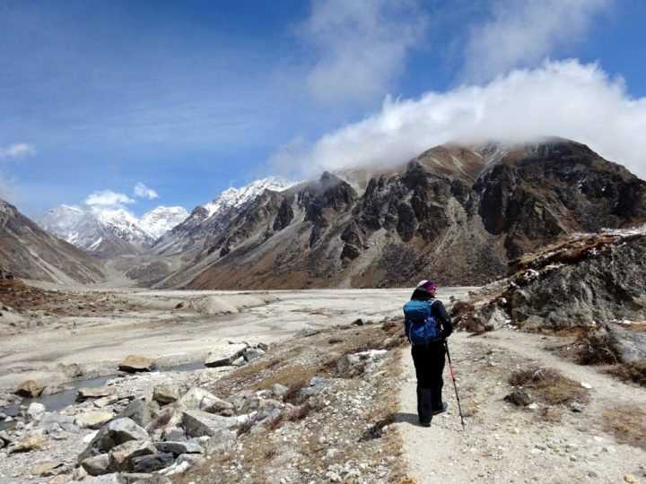
In the Himalayas, things get better the higher you climb. The next day had a unpromising start, but it redeemed itself and more. There had been a bit of snow overnight, covering the ground in a carpet of white. We set off in mist at 7.30, ambling slowly, but we were not cold. The trail climbed high above a wide, boulder-strewn valley. Occasionally it dropped down to meet the river, and these times the going was not so pleasant as we hopped across boulders.
The mist hid the landscape from view for most of the morning, but always we felt the presence of high peaks towering overhead. And a treat was in store for us. The sun came out for the final section into Lhonak, which was in the most beautiful setting. An enormous side valley joined ours, and at the junction a huge sandy flood plain had formed. It felt like we were wandering across grassy sand dunes on a beach. To the north, three pointed peaks rose up at the end of the side valley, and to the south a giant wedge-shaped peak towered over the glacier, called, appropriately enough, Wedge Peak.
The village of Lhonak, half a dozen wooden teahouses, sat in a pleasant grassy plain in one corner of this huge open space. The sun was beating down, there was plenty of green space, and it was a fantastic place to camp.
After lunch Edita and I wandered up a grassy mound above the village and looked east to Tent Peak and Nepal Peak on the Indian border. On the north side of the valley, the gently-sloping snowcap of Tengkoma Peak obscured our view of Drohmo Peak, the unclimbed giant whose shoulder we were hoping to climb.
At the top end of the valley we could see three smaller peaks, one of which could be ours. None of them looked difficult, but the highest had quite a bit of snow that could make it more challenging.
The sun remained all afternoon, and we were even able to wash and dry our clothes at 4,760m, something we weren’t expecting. Later Gombu came over to tell us there were more blue sheep grazing on the hillside behind the village. We grabbed our cameras and raced outside. There were about 50 of them. We were able to get very close and watched them for about half an hour. They were true rock climbers, skittering quickly and confidently up and across sheer rock faces.

We had a short day of only three hours up the valley to Pangpema, base camp for Kangchenjunga on the north side. There had been a light dusting of snow during the night, but the sun was high over clear blue skies, so it would soon melt.
We left at a leisurely amble. The going was gentle, but I was still not acclimatised, so I took it easy. It was scenery to strum the heart strings, among grassy moorland in a broad, glacial valley. The trail kept mainly to grass, occasionally traversing banks of moraine where the moor had eroded and tumbled into the glacier. To the left a rocky hillside terminated in a snowy top: Tengkoma Peak. To the right, on the opposite side of the glacier, Wedge Peak looked more and more severe with every step.
As we walked, we tried to identify our peak, Drohmo Ri. At first we thought it was the one looking up towards the dramatic fluted summit ridge of Drohmo Peak. But as we approached Pangpema, Edita noticed that this peak fell away into cliffs that did not match Jamie’s description. In the end, we concluded that our peak was one that looked to be a gentle bump rising directly above the teahouse in Pangpema. One of the Swiss trekkers had been up it, and he told us it took him 3½ hours, and according to his map was a little over 5,900m. It didn’t look so high, but appearances can be deceptive.

In fact this was not the peak Jamie had intended us to climb, but it appeared to be relatively snow free. We thought we could risk climbing it in just our approach shoes, and not the heavy mountaineering boots and crampons we had brought with us just in case.
In any case, our attention was diverted to the opposite side of the valley. Kangchenjunga and Yalung Kang had appeared and they screamed for attention. The first was a triangle of ice-laden rock, while the second appeared more rounded from this angle. I was able to identify the north col and west side of the north ridge that Pete Boardman, Joe Tasker and Doug Scott climbed in 1979. It looked extremely difficult with a lot of tricky rock climbing at a severe altitude.
There was a single teahouse at Pangpema, near the junction with the glacier that led up to Kangchenjunga’s north face. Being so remote, it was a seasonal teahouse, but the owner had come up from Lhonak to feed the Swiss trekkers. We passed him on his way back. He immediately turned around and returned with us.
The camping ground at Pangpema was not as pleasant as Lhonak, with rocks and dust and only a few grassy outcrops, but the view across to Kanchenjunga, 3,500m above, was one of the wonders of the Himalayas.

We followed Jamie’s advice and agreed to leave at 6am the following morning to climb Drohmo Ri. We woke up in the dark at 5am and packed up all our things so that the porters could carry our bags down to Lhonak while we climbed.
We had a 5.30 breakfast of chapati and fried eggs in the smoky kitchen while the porters slept under a shared blanket in the corner. It was fully light by the time we left at 6.10. There was a thin mist over Kangchenjunga, but this soon lifted as we made our way up the hill.
I was happy to discover there was a good trail most of the way up. By 7am we had already climbed 250m. We stopped for a rest and a snack beside a large truck-sized boulder. Behind us was a fantastically clear view of Kangchenjunga right up the glacier that was hidden from view at Pangpema. Gombu, who had been employed on a disastrous expedition with a Korean team in 1999, described the climbing route up the left side of the glacier then left behind the 7,000m peak known as the Twins.
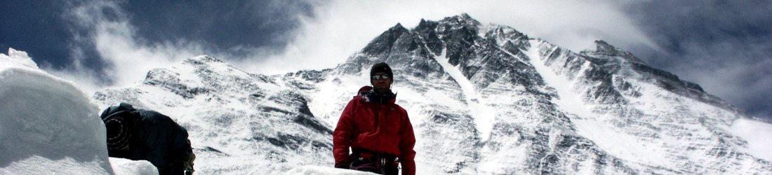
We made good progress on terrain that was no more than a steep trek. By 8am we had reached 5,700m. At each brow we could see more rocky mountain above us, and I started to get excited that perhaps this peak really was more than 6,000m, like Jamie said it might be. If this turned out to be true then it would be by far the easiest 6,000m peak I had ever climbed.

The last 200m of ascent was a steep scramble across boulders. Towards the top there was a dusting of snow in the cracks. This peak would be a tougher proposition after a hefty snowfall, with a constant risk putting a leg down a crack. But today, our approach shoes had proved to be appropriate footwear.
At last the monotonous plodding and boulder hopping ended and there was a short summit ridge over snow and rock. We reached the top at 9.30. It was a very distinct summit that dropped away steeply on all sides. To the north we saw that the unclimbed Drohmo Peak was an impossible crest of fluted snow. It enclosed our peak on the whole northern side, with a horizontal snow spur enclosing our west side at much the same altitude as we were.
On the east side, Drohmo Peak’s knife-edge ridge continued round at a much higher altitude, obscuring much of Tent Peak and Nepal Peak on the Indian border. These were impressive peaks in their own right, but they were dwarfed by the 3,000m north face of Kangchenjunga, a frightening wall of black rock and hanging seracs that looked ready to collapse at any moment. The whole southern scene was crested by the summits of Kangchenjunga Main (8,586m), Yalung Kang (8,505m) and Kangbachen (7,802m) all in a line, with the bullet-topped summit of Wedge Peak (6,802m) on a separate ridge in front and to the right.
The moment of truth came, and I took GPS readings to determine the height of this peak. Three readings provided an average of 5,958m. Alas, not the magic 6,000m, but the summit had been too easily gained for that.

We spent about half an hour on top and we shared a few snacks as we gazed upon this amazing panorama.
It was time to descend. We followed a ridge down 200m to bypass the awkward boulder field, then Gombu picked up an obvious trail back down off the ridge. But this soon disappeared in the loose scree and boulders.
Our descent became a shitty scramble (not the official phrase, but one that’s easily understood). Edita and Gombu decided to stick together over loose boulders, but I tried scree running. I made two attempts, but ended up on my backside both times after setting off mini rock avalanches. Edita and Gombu were afraid and shouted at me, but I was in no real danger apart from a bruised ego.
The trail had been easy to ascend, but was hazardous and loose to take back down again. Edita and Gombu had chosen the wiser if more painstaking option by taking the boulder fields.
It wasn’t much fun, but we made quick progress and were back at Pangpema at 11.30. We had a macaroni lunch on the flat spot that had previously been occupied by our tent. The teahouse man put down a soft mat, and Edita created a makeshift table out of a slab of slate and two flat rocks. Kangchenjunga was partially in cloud now, but it was still warm and sunny, and a wonderful setting for a picnic lunch.

This was the most expensive place on our whole trek. The dal bhat alone was 1,000 rupees, and although we paid a tourist rate for food, Gombu told me that even the porters had to pay 800 rupees. Such is the price of cooked food in this remote and inhospitable location.
We left for the trek back to Lhonak at 12.45. It was enjoyable coming up, but in a tired state the walk back was tedious. I had forgotten how much up and down there was over awkward terrain, including some long landslide areas.
It was blissful to cross the last grassy field and arrive back in Lhonak at 3pm to find our tent pitched in the sun. I made a cursory danybad to our porters and collapsed inside. We spent a peaceful afternoon resting with the sun on our tent. Drohmo Ri had been an enjoyable excursion, and the view from Kangchenjunga’s north base camp had exceeded our expectations.
We were halfway through our trek, and we still had the south base camp to come. Read part 2 here.
See my Kangchenjunga Flickr album for all my photos of the trek.


Sounds wonderful! I’m glad you were able to climb up (and down) Drohmo Ri despite the misunderstanding with the guide company.
Hi Mark, it sounds like everything went ok to that point. What month did you go as i went in May and the weather was terrible – we abandoned our walk to Pangpema as it was cloudy all the time. Only afterwards i read somewhere that spring is a bad time to go – just my luck! Luckily we saw Jannu and Kanchenjunga from the south side which was cool. I was told late October/November is the best time to go…
We went last month. It sounds like you may have been unlucky. Spring is a good time to go to Nepal, but there is always a chance of bad weather any time of year. It tends to be colder but clearer in the autumn season (Oct/Nov). In the spring season (Apr/May) it’s warmer, but also more cloudy, particularly in the afternoon, so early starts are important.
Lovely to read this account. I visited both base camps in November 1990 with several fellow horticulturalists and had a wonderful time. I still keep in touch with our sirdar, Chheduk Man, and his son, who now runs his company – very odd to receive Facebook messages from Annapurna and elsewhere! I think things have changed so much in Nepal since I was there.
Vivid and detailed description. Splendid photography. A wonderful blog.
If you get a bit of time out of your busy schedule, can you please share the contact of a person(s) who can take me/us for a trek in the Pang Pema region?
Would be forever grateful for this.
Great blog and excelle photos