
The Cima Grande … would not be so beautiful or so striking if it were not a part of the trinity of the Tre Cime. Gaston Rebuffat, Starlight and Storm
Back in July, Edita and I did a brief hike in the Dolomites, a range of dramatic rock peaks in north-east Italy. I didn’t have time to write a full report then, and scribbled down a few notes instead. Here is the report now. I hope it was worth waiting for.
The Apennines were our home from home while we lived in Italy, but I always wanted to visit the Dolomites at some point too. I finally had the opportunity in the very last week before I moved back to London.
We decided to spend four days in the Sasso di Sesto region of the Dolomites. It’s one of the busiest, but I’ve had a craving to complete a circuit of the Tre Cime di Lavaredo ever since reading Gaston Rebuffat’s book Starlight and Storm many years ago. Rebuffat said of the Cima Grande – the largest of three peaks – that “the first 720 feet are definitely overhanging, and the rest is vertical”. Since getting to the top of this monster was clearly going to be impossible, walking all the way round it seemed the next best thing.

Apart from this, we had no clear plan but to explore as much as we could of the area, hopping from hut to hut. We had a good map which marked all the trails, but some of them were marked as via ferrata. Vie ferrate are more exposed sections of trail which contain steel cables, handrails and sometimes ladders to make them more accessible (I talked about them in a little more detail in a previous post). Some of these can only be tackled with safety equipment, which we didn’t have. The map didn’t indicate severity, so we had to approach the via ferrata trails with caution and be prepared to turn around if things became too hairy.
We started from the village of Schluderbach Carbonin, in forest on the west side of our intended route. We planned on walking east up a valley to Rifugio Locatelli, where we’d booked beds for the night. This involved an ascent of 1000m, but we soon discovered that we were covering distances on our map very quickly. We decided to take a diversion up a trail that led over a mountain called Monte Piana. There were lots of vie ferrate marked on the map, but we had plenty of time, so we decided to give it a try.
It was a good trail up through forest, and the two short sections of via ferrata were straightforward. An exciting section took us along a trail hewn into a cliff face, where we overtook a guided group of around twenty people. The summit was a huge grassy plateau (hence the name: piana means plain) covered with limestone pavements.
We didn’t know it, but Monte Piana is a historic place. During World War I it was a battleground, with Italian troops occupying the southern side against the Austro-Hungarian army on its north side. The summit was littered with concrete bunkers and barbed wire, which remain as a permanent outdoor museum.

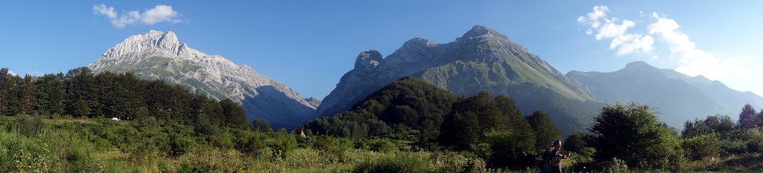
Cima Ovest, the second highest peak of the Tre Cime di Lavaredo, rose like a skyscraper across the valley. We could see Rifugio Locatelli perched on a ledge to its left. On the opposite side were Monte Cristallo and Croda Rossa. It was easy to see why this place had once been a focus of military strategy.
We found the trail leading off the opposite side of the mountain, and dropped steeply through pine forest into a quieter valley. Here we turned left and walked alongside a bubbling stream until we reached the Valle della Rienza, the valley we had originally intended to ascend to the Rifugio. It was now mid-afternoon and cloudy, but the views were about to get even better.
At the top of valley, the trail zigzagged steeply up to a meadow where cows grazed amid a cacophony of giant bells hanging from their necks. Towards the top, the Tre Cime suddenly appeared right next to us, like a set of ancient teeth that had been ground down over the centuries.
We reached Locatelli hut at 4.30. It was staggeringly busy, but the staff were extremely quick and efficient. In no time we were perched on the end of a crowded bench with coffee, chocolate cake and beer. In the corner of the dining room was a telephone and a list of numbers for all the other nearby huts. We decided there and then to ring round and reserve our accommodation for the next two nights. Our itinerary was thus dictated by availability. Two of the huts were fully booked, but the Rifugio Carducci offered us the use of their “emergency beds” in the dining room, while the Rifugio Auronzo (which is enormous) had availability.

At six o’clock everyone with a bed assembled in the dining room, where we were treated to a fantastic three-course dinner. The restaurant was packed, but the service was still good. It was noisy, and there were lots of families with squealing kids. We discovered that this busy corner of northern Italy is more German than Italian. All of the staff spoke perfect English, but the first language for all of them appeared to be German. The menu was in German, and the waiter who served us seemed surprised when we asked for a menu in Italian.
“You speak Italian?”
We nodded. “A little.”
I thought he was going to faint in shock.
We left Rifugio Locatelli at eight o’clock the following morning and climbed Sasso di Sesto, a small peak rising above the hut. It was clear and sunny, the best morning of our hike, and probably the finest viewpoint we had of the surrounding peaks. We could even see some snowcapped mountains in the Alps to the north. The Sesto Dolomites rise to over 3000m, but in July their severe rock faces and tops were free of snow.

The summit of Sasso di Sesto is a fantastic place to view the Tre Cime di Lavaredo. While gazing across to the three jagged teeth we decided to do our complete circuit of the Tre Cime that morning.
From Rifugio Locatelli we crossed the cow meadow, then walked anticlockwise round the east end of Cima Ovest, the western of the Tre Cime. The trail was quiet to begin with, but it gradually became busier as we approached the Rifugio Auronzo, where there was a car park of a similar size to the one at Heathrow Airport. We reached it at 11am, and this is when things got silly. If I thought the summit of Snowdon gets busy on a weekend, I knew nothing. Compared with the Dolomites in July, Snowdon is like a deserted town in the Wild West with tumbleweed blowing across the main street.
We walked straight past the Rifugio Auronzo and found ourselves on a wide road, where we had to press through a mass of bodies of a thickness you’d more commonly expect at the front row of a Justin Bieber gig. At any moment I was expecting to see underwear thrown at me.
We tried to stroll as briskly as we could to the next hut, Rifugio Lavaredo. We were skirting right beneath the south face of the Tre Cime, but too close to get a decent view of them. Rifugio Lavaredo was a much smaller hut built on an open grassy area at the eastern end of the Tre Cime. Outside the hut it felt like Hyde Park on a sunny bank holiday; dozens of people were sitting on the ground or at picnic tables, enjoying the sunlight. We were surprised to find that it was relatively quiet inside, and we were able to sit at a table with coffee and chocolate cake. To underline that the area was more German than Italian, we were able to order cappuccino a few hours after breakfast without dramatic protests from the waiter.

It wasn’t yet lunchtime on the second day, and we had almost completed our circumnavigation of the Tre Cime. We took a high trail back to Rifugio Locatelli marked on our map as “for expert hikers only”. We overtook many novice hikers who (and I’m speculating here) weren’t carrying a map. Above our trail we could see an even more expert via ferrata that disappeared into a tunnel in the rock. This was the easy route up Monte Paterno, a rocky needle rising above the south-east side of Rifugio Locatelli.
The hut itself had turned into another seething Bieber-fest in our absence, but it became significantly quieter, if not exactly quiet, as soon as we rounded the north shoulder of Monte Paterno and turned into a pleasant hanging valley with a pair of shimmering silver lakes.
It was sunny again as we traversed along a high scree trail beneath a rocky ridge. This trail then climbed to another high pass where several trails converged. There was more traffic here. As we sat on the crest of a ridge eating our lunch I heard one man describe it as an “autobahn”, but for a Londoner it was more like Piccadilly Circus.
We moved on, passing a quaint hut directly on the ridge (Rifugio Pian di Cengia), then another larger one in a basin above a steep valley (Rifugio Comici). Beyond Comici Hut we could see another scree trail climbing up to a pass. It was now mid-afternoon, and this was our last climb of the day. Above the scree slope we could see another more severe trail leading beneath a towering pinnacle of rock. I realised that we would take this trail the following day.

It took us an hour to reach the pass. At the top we looked down into a secluded combe surrounded by mountain walls. Rifugio Carducci perched on its rim, at the top of a steep drop into the valley below. We could see via ferrata climbers coming down from a stupidly vertical mountain to our left (Cima Undici).
We arrived at the hut at four o’clock. We were the only people there, and this gave rise to the hope that we might be spared the “emergency” beds, and have real ones instead. The dining room was decorated with many historical photos of the hut under construction. There was also a Nepalese feel, with Buddhist prayer flags, photos of Everest and Ama Dablam, and a signed photo of the Italian high-altitude mountaineer Simone Moro visiting the hut.
Edita started chatting to one of the staff, who said that she spent four months a year working in the hut, two months working at bar in Cortina, and six months travelling. She stayed here for the entire four months, never descending to the valley. All the supplies were brought in by helicopter. Later in the evening she got upset when another guest threw an extra log on the fire without asking.
Carducci turned out to be a via ferrata hut. We appeared to be the only hikers there, which explains why we had the place to ourselves when we arrived. All the other guests arrived much later in the afternoon after completing longer mountain routes. It seemed that we would have the emergency beds after all.

At dinner we sat next to a young Austrian couple who explained the via ferrata grading system to us. ‘A’ is essentially hiking, ‘B’ is a bit more technical, ‘C’ might have ladders, while ‘D’ will require rock climbing while clipped into a cable. ‘E’ probably involves overhangs.
“You don’t want to fall,” one of them said. “You will fall all the way to the next anchor.”
They told us about their extreme C/D via ferrata today. Another climber was hit by a rock, broke an arm and had to be helicoptered off the mountain. In exchange for all their useful information, we told them about Kilimanjaro, which they were thinking of hiking up.
We had to wait until 10pm before we could go to bed, when they turfed all the other guests out of the dining room. The emergency beds were as comfortable as any normal bed. They were custom-designed, and formed by lowering the table to the height of the benches either side and adding a mattress. We slept well.

On the third day of our hike, we left Rifugio Carducci at 7.30 and reascended to our pass of the previous afternoon. Across the other side we turned left along the high trail above the top of the big scree slope. There was one difficult section where the trail almost vanished, but otherwise it wasn’t as hairy as it looked from below.
We ascended to another high pass and turned left on a trail below a rock face. The pass was at 2500m, and we intended to descend all the way to 1100m before coming back up again. On our map the trail down to the valley was marked as for expert hikers, but on this occasion the map was out-of-date.
Edita noticed some paint marks leading down a ridge. We followed them until they curved sharply down a gully. The trail became absurdly steep. I peered over the edge and saw an overhanging vertical section with loops of metal hammered into rock. This was no trail for expert hikers, but a challenging via ferrata route.
“Bollocks to this,” I said.

We retraced our steps up the hill and realised that we’d turned off the main trail too early. We could keep below the cliffs until an easier trail led down a steep scree slope, but there was still part of the trail that we couldn’t see. We passed an older Italian hiker looking down another steep gully. We followed the trail where his eyes were gazing as it led down the gully and became a severe via ferrata. I continued down the gully until the trail disappeared around an exposed rock face. I couldn’t see around the corner, but below it I could see that the via ferrata fittings were hanging in mid air.
“Bollocks to this too,” I said as I turned around.
The Italian hiker asked us if we had technical equipment, We said no. He told us there was a landslide a few months ago which buried the route. A guide came a few days ago and fixed a rope. The hiker had come to have a look, but said he will probably turn back here too.
Our map showed another trail leading down into the valley. We circle round to it on a high trail, then descended to a broad plateau below Rifugio Lavaredo. It was ten o’clock. The hordes of hikers were starting to appear, but we were soon to escape them. We turned off and descended all the way to a forested valley at 1350m. We passed only one other hiker with a dog, who – Sod’s Law – appeared around a corner as I was having a pee. Otherwise we didn’t see another person for six hours, in stark contrast to the mountains above, which were a seething mass of human flesh.

We had plenty of time, so we decided to take a longer route to Rifugio Auronzo, ascending a forested valley, all the way up to 2200m. We were in gloomy pine forest for much of this ascent, apart from a more open section where the trees had been swept away by a landslide. The trees thinned out towards the top of the valley, where there was another set of dazzling rock towers, the Cime Cadin dei Tocci. They rose like jagged teeth and were almost as impressive as the Tre Cime di Lavaredo, but I’d never heard of them. Judging by the tranquillity of this valley, neither had anyone else.
I felt at peace and satisfied when we reached the pass at the top of the valley. The forest was below us and the granite spires towered above. But Edita spied another via ferrata route up an adjacent peak, the Cima Cadin de Rinbianco. She was determined to take a shortcut over the top to Rifugio Auronzo, but I refused in no uncertain terms. We weren’t equipped for severe via ferrata, and extreme exposure without protection is not my thing. She was upset with me, but I could see the trail heading up a vertical rock face, and there was no way I was going up it.
We descended for 300m across cow meadows, then ascended another 400m through trees. Edita was bored.
“We could be anywhere,” she said.
But I looked at the vertical rock faces all around us and disagreed.

For the last forty-five minutes of that day’s walk, we could see the Auronzo hut high above. We climbed beside the road up to the car park, shortcutting its zigzags on a footpath.
We arrived at the hut after five o’clock, late enough for most of the day trippers to have left for the day. The huge four-storey hut felt virtually empty, and we were pleasantly happy with it. Despite having its own enormous car park, it was a complete contrast to Rifugio Locatelli, which had been heaving with guests.
The windows of the comfortable dining room looked down to the lakeside towns of the Marzon Valley we had descended into earlier in the day. This view passed in and out of cloud as we ate our dinner. When darkness fell, the scree on the nearby hillside looked like snow in a black and white world.
We had quite a lot to drink that evening. I bought a mezzo litro of vino rosso from the buffet, only to find that Edita had bought another one. This may have been an accident, but it also made sound economic sense. Half a litre of red wine cost €5, while a litre and a half of water cost €4. At that price I was willing to brush my teeth with red wine too.

The following morning, the fourth and last of our hike, was cloudy and grey. I looked out of the window and could see nothing. The forecast was for poor weather, but we only had a short walk over Monte Piana to return to our hotel in Schluderbach Carbonin.
We traversed beneath the Tre Cime and had a discussion about whether to divert up a pair of minor summits called Croda de L’Arghena, which looked across a valley to Monte Piana. We didn’t expect to see anything from the top, but we had lots of time. We were undecided, but when we reached the turning point at the comparatively early hour of nine o’clock, Edita decided to stride on up.
It was a good decision. The peak itself was nothing special, but the diversion caused things to fall into place later in the day. The trail contoured round the first peak then headed up the second one. There was a short ten-metre scramble up a rock step. We were off the beaten track, so we left our sticks and packs at the bottom and climbed up. The summit was overgrown with pine bushes and it wasn’t a great view point, but we’d enjoyed the walk.
We descended south through forest into a land of warm sunshine. There is a road up the south side of Monte Piana to a hut, the Rifugio Bosi at 2205m. We walked along the road for a bit, before finding a steep shortcut up a trail.

We reached the hut at midday, just as it was opening for lunch, so we stopped in the restaurant for a meal and a couple of pints. We seemed to be the only people who had walked up, and were the youngest diners by around 30 years, which made a nice change. The food was awful, but it had been an enjoyable break for us, and the hut had its own tiny museum containing an amazing assortment of war relics picked up from the mountaintop: grenades, shells, guns and barbed wire.
After lunch we wandered across the mountaintop and peered into the bunkers. By now the sun had found a gap in the cloud and it was pleasantly warm. We located the 6A trail down to Schluderbach Carbonin and stopped on grassy banks, lying in the sun as we admired the view for one last time.
I wondered about the final via ferrata section down to the village. We could never tell from the map how severe they were going to be, but when we saw a man with a dog descend ahead of us, I realised it was going to be OK (the dog wasn’t carrying safety equipment). In fact the via ferrata turned out to be via legna. Instead of steel cables, there was an rickety set of wooden steps up a steep section of rock. It felt like we were on an old ship.
We waltzed down the remaining 900m through forest to join up with our trail of three days earlier. We arrived back to our hotel at 3.30. The day had been cloudy above, but sunny below. It was much warmer than it had been on our first day, when the mountains felt surprisingly chilly for a July day in Italy.

It had been a gentle four-day hike, my first introduction to the Dolomites. Logistics are easy here, with good trails, excellent maps, and comfortable huts with food and lodging at regular intervals. The mountains are wonderful to look at, but as for climbing them, that depends on your preference. They must be a heaven for hardcore rock climbers, but hikers need to remain at a lower altitude unless they have a craving for via ferrata. Time will tell whether I decide to explore them further.


I plan on doing the Alta Via 1 next year but hope to do it in June to avoid the crowds. How’s the weather there? And are the rufugio places expensive to stay in?