
In my Kilimanjaro trip report last week, I enthused about Kilimanjaro’s inner crater, and said that I considered it to be the jewel in Kilimanjaro’s crown. Despite this, the overwhelming majority of the 40,000 or so people a year who climb this giant volcano – perhaps as much as 99% of them (a wild guess on my part) – don’t actually get to see it.
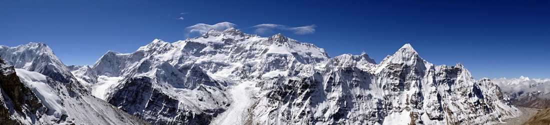
In this post I’m going to talk in a little more detail about what they’re missing out on. But first, here’s a photo I took of it.

Pretty amazing, eh?
So why don’t most of the people who go to the effort of climbing Kilimanjaro come to look at this, the best bit – are they stupid or something?
The answer is that nobody ever tells them about it, so they don’t know any better. I was the same, when I first climbed Kilimanjaro in 2002. In Seven Steps from Snowdon to Everest, about my journey from hill walker to Everest climber, I described the moment when I stood on Uhuru Peak, Kilimanjaro’s highest summit and the highest point in Africa, and looked down into the crater.
When I looked down into the crater I could see the gap in the crater wall just beyond Uhuru Peak known as the Western Breach, best known as the most direct and toughest route to the summit … beyond the Furtwangler Glacier the land rose again, to what I assumed to be the opposite side of the crater rim. It was only later I learned it was another crater.
In fact Kibo, Kilimanjaro’s main summit, contains three concentric craters. The outer one is about 3km long and 2km wide. This is the one that most of those 40,000 people walk around a small part of to reach Uhuru Peak, the highest point on the outer crater rim. The inner crater is about 1,300m in diameter and is also known as the Reusch Crater. I was standing on the rim of this crater when I took the photo above. Inside it you can see the third crater disappearing into the ground. This one is known as the Ash Pit, and is just 140m wide.
So how much of this do most people get to see? I have Bob Schelfhout Aubertijn to thank for drawing my attention to the following aerial photo of the whole of Kibo, taken in 1938.

The answer is about a quarter of the outer crater, perhaps a little less – the section of crater wall that you can see in the top left of the photo. Gillman’s Point, where trekkers on the Marangu and Rongai Routes arrive on the crater, is more or less the lower point of the outer crater on the left of the photo. Uhuru Peak is the high point on the cliffs at the back. Stella Point, where trekkers from the Machame, Umbwe, Lomosho and Shira Routes reach the outer crater, is somewhere between the two. The Western Breach is the gap in the outer crater wall at the back of the photo, and the Northern Icefield is the big glacier on the right.
So the longest section of the crater that most people visit, is the length of the outer crater between Gillman’s Point and Uhuru Peak. As you can see, there’s a whole lot more to the summit than that. More importantly, at no point on that section can you see the inner crater because it lies inside a small hill.
All you can see is the hill. Here’s what it looks like from Gillman’s Point. The hill containing the inner crater occupies the majority of the photo, while the cliffs of Uhuru Peak are on the left.

Is Kilimanjaro still active?
Kibo’s last major eruption was 360,000 years ago, and its most recent activity about 200 years ago. For a few years after it was first climbed by Hans Meyer in 1889 people assumed that it was extinct, just like Kilimanjaro’s other two summits, Shira and Mawenzi. Meyer was a geologist, and he didn’t find any evidence of volcanic activity.
But when Bill Tilman climbed Kibo solo in 1933 he descended into the crater, walked up the hill to the Reusch Crater and looked down into the Ash Pit. He said that “sulphurous fumes rose from the lip and pieces of sulphur lay about”. He also took some rock samples.
Tilman’s claim of seeing volcanic activity was disputed by others who had been there, including the same Richard Reusch after whom the inner crater had been named. Reusch had this to say:
I was surprised to read in Mr. Tilman’s record that he had seen sulphur fumes in the northern part of the crater. I looked for these today but could not find any traces of them. I am afraid Mr. Tilman must have mistaken a certain kind of whirling, little clouds resembling smoke for the sulphur fumes.
But perhaps it was Mr. Reusch who had been smoking – or maybe he had a cold. As I mentioned in my trip report last week, we clearly smelled sulphur when we arrived on the rim of the inner crater, and even used the smell to navigate on the way back in thick cloud.
Tilman’s evidence was convincing enough to persuade the vulcanologist J.J. Richard to climb up to the crater. Richard made separate visits between October 1942 and February 1943, and discovered an increase in thermal activity during that period. He concluded that Kibo was not extinct, but dormant. If you’re into that sort of thing, you can read the whole of his scientific paper online. It also contains some history of previous ascents.
He makes an entertaining observation about why people don’t get around to viewing the crater which is as true today as it was back then.
The amount of energy and the time required to climb the highest point, form the main reasons for this apparent forgetfulness.
Kilimanjaro’s shrinking glaciers
Kilimanjaro’s summit crater is also home to its glaciers, but for how much longer? When Hans Meyer first climbed it, he invited an alpinist Ludwig Purtscheller to join him, because he knew there was a lot of ice, and they would need alpine skills to get up. The account of his ascent – the step cutting, and the crossing of snow bridges and crevasses – is unrecognisable to those of us who trek up it now. They climbed an ice sheet called the Ratzel Glacier, east of Stella Point, that no longer exists. When Meyer returned to climb Kilimanjaro again in 1898, he was shocked to discover it had retreated 100m in only nine years.
One scientific paper written in 2007 provided some shocking statistics. According to Meyer’s rough survey, there were 32km2 of glacier in 1889. By 1912 this had shrunk to less than 20km2. In 1953 there were just 11km2, and by 2003 less than 4km2.
At a time in our history when climate change denial is in danger of making a comeback, it’s worth pointing out that climate change is not a political issue, but a reality, just like hunger, conflict, ill health and poverty.
If we don’t want to believe scientists, we have the evidence of our own eyes. Being mountain lovers, many of us have been to places where the evidence of shrinking glaciers is all too stark. I have many examples, including this one from the Himalayas, another from the Andes, and now the following example of the Furtwangler Glacier on Kilimanjaro. The photo on the left was taken from Uhuru Peak in 2002, and the photo of Edita sitting at Uhuru Peak was taken last month.

As you can see, the Furtwangler Glacier appears to have halved in size in only fourteen years. The most recent (2011) version of Giovanni Tombazzi’s popular map of Kilimanjaro even marks it as Furtwangler Glaciers (plural) to indicate that it’s no longer just a single piece of ice. By the next version he can probably revert to the singular again, as the two smaller pieces are now really quite tiny.
You can also compare this aerial photo of Kibo, taken in 2014, with the earlier black and white one taken in 1938. You need to bear in mind that the top one contains a lot of snow, which comes and goes with the seasons, but even so, the bulging sections show plenty of evidence of permanent (by which I mean year-round) ice. In the second photo much of this has gone.

But are we causing the glaciers to shrink more quickly by visiting the summit? The Furtwangler Glacier was our water source when we camped in the crater in December, but our kitchen crew harvested it not by hacking bits of ice off it, but by putting their pans underneath a water spout where the ice was melting anyway.
Scientists currently believe the main reason Kilimanjaro’s glaciers are disappearing so quickly is not because global warming is causing the ice to melt more quickly, but because there is less snowfall replenishing them. It’s a trend which has been going on for centuries as part of the Earth’s natural climate cycle, but it has also been accelerated by human activity. In the last century many trees were cut down to make way for fields and houses, causing the air to be less humid. This in turn has meant less snow up at 5,895m.
Some have predicted that Kilimanjaro will be ice-free by 2030. From what I have seen I can well believe that the Furtwangler Glacier will be gone by then, but I believe the Northern Icefield will last a little longer.
What can we do, as trekkers? It’s important to choose your operator carefully, and ensure they care not only about their environmental impact, but their local community too, looking after their staff and supporting sustainable projects. As well as using our water source sustainably, our staff brought a portable toilet up to the crater, so that our waste could be carried back down. One of our porters was a Masai who was working on Kilimanjaro for the first time. The altitude would have been a shock to him, so he was given a rest day when we camped on the crater. He stayed down at Kibo Huts when we climbed to the summit. The operator we used also run their own charitable foundation to support local community projects.
The ice may be melting, but the mountain and its beautiful crater will remain a little longer. As I said last week, the best way to enjoy Kilimanjaro is to spend a night on the crater and look down into the Ash Pit. It’s no easy matter to camp above 5,700m, and potentially dangerous because of the risk of altitude sickness. But if you have the altitude experience, then don’t just go to Uhuru Peak; see the rest of the summit. It’s amazing.


Very enlightening Mark.Chrystabe
I was lucky enough to camp at the summit in 2012 allowing time for a full circuit of the craters, an incredible experience and one that will stay with me always. It is a shame that so many people don’t get to see the full beauty of the summit crater but if they did, I suspect it would become as strewn with litter as the rest of the mountain. We collected a bin bag full of rubbish every day of our climb and descent.
Anyone wishing to camp at the summit needs a permit and it is my understanding that it is now compulsory for you to take a portable toilet with you to the summit to help maintain the environment – we certainly took one with us.
If you get any opportunity to see the inner crater it is something incredible to behold but please be responsible when you go. I fear the Furtwangler Glacier will be long gone before 2030.
Well said, and well done with the litter picking. 🙂
Pingback:Fact Check: No, This Viral Video Is NOT From Mount Kailash But Mount Kilimanjaro | Newsmobile