
“Climbing and hiking in remote mountainous regions such as the Cordillera Huayhuash is dangerous; if you are not convinced read Touching the Void by Joe Simpson.”
Warning disclaimer on the Alpine Mapping Guild’s 1:65,000 map of the Cordillera Huayhuash, Peru
By the time you read this I will be in Peru, setting out in the hope of climbing its highest mountain, 6768m Huascaran. It’s been a long time coming. My one and only visit to Peru was when I walked the Huayhuash Circuit as a novice trekker in 2002. I was a keen hill walker in the UK for years, and earlier that year I quit my job and did my very first high altitude trek, pootling around the Annapurna foothills in Nepal and walking to the (then) staggeringly thin air of 3800m at Tengboche in the Khumbu region. I hoped the Huayhuash Circuit would be a little more challenging: 14 days of camping in a remote mountain landscape, crossing seven high passes and climbing above 5000m. Despite the warning on my map, I hoped it wouldn’t be like Touching the Void, Joe Simpson’s classic tale of two mountaineers making the first ascent of the West Face of Siula Grande in Peru’s Cordillera Huayhuash and getting into a spot of bother on the way down.

Back then I wasn’t sure how my brain and lungs would react to being at 5000m. My trekking guidebook hadn’t been very helpful on this count and made it sound like I was almost certain to die.
“High altitude cerebral edema,” it explained, “is a swelling of the brain tissue caused by the build up of fluid in the brain. A severely inflated brain can prevent the blood from flowing to it. This means oxygen cannot reach the brain and it will cease to function.”
This sounded quite severe, although the symptoms seemed a little more bearable. I could expect severe headaches, persistent vomiting, loss of coordination, staggering, falling, blurred or double vision, confusion, hallucinations, and loss of mental faculties such as memory. This really wasn’t very much more than I had experienced many times during a bad night on the booze.
I decided to give it a try, and was given an unusual practical demonstration of this “swelling of the brain tissue” on the very first day of the trek. We learned our first campsite was sited on the school football pitch in the village of Llamac, so we bought a ball in Huaraz in case anyone fancied a kickaround after the first day’s trek. We had it pumped up and stored it in my kit bag to be carried by a mule, but as things transpired I was lucky that particular mule managed to make it to Llamac in one piece without shitting itself in terror and galloping over a cliff. When I opened my duffle bag in Llamac I discovered the football had exploded due to the pressure differential between the air inside the ball and the thin air of the high altitude cordillera. At that stage we were only at about 3000m, and if that kind of thing was also happening to my brain tissue, by the time we reached the highest pass of the trek at just over 5000m I would be needing some sort of close-fitting helmet tied around me to stop my head exploding. Or perhaps I should make a small incision in my skull to release the pressure gradually. The health advice section in my guidebook was wholly inadequate and recommended none of these things.

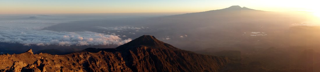
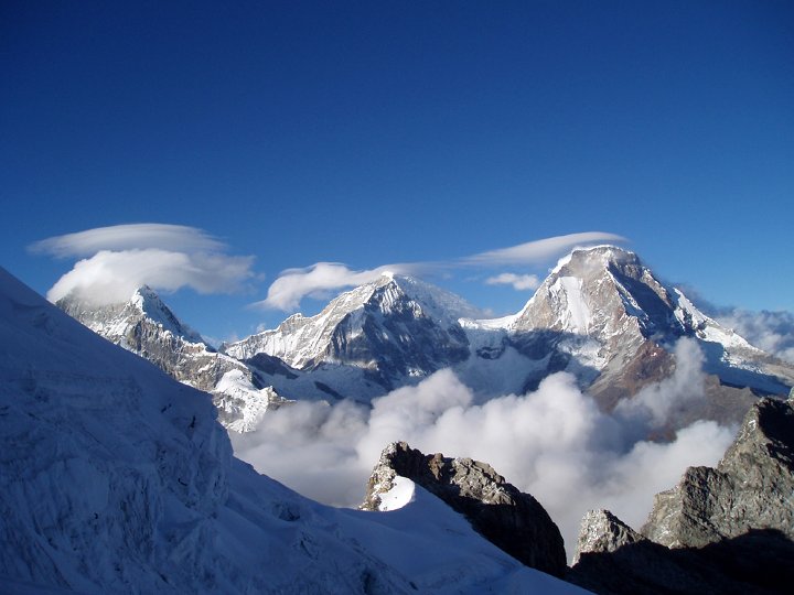
Happily despite having a brain that was being slowly inflated like a sack of water, my first experience of the Peruvian Andes was far from being the terrifying ordeal my guidebook warned me of. It was the best holiday I had ever been on. The majority of the Huayhuash Circuit kept at a constant 4000 metres or above, on many days rising much higher to cross a pass and descending back down again. The Cordillera Huayhuash and its neighbouring mountain range the Cordillera Blanca sit on the main South American continental divide. While everything to the west drains into the Pacific Ocean only 100 km away, the eastern side drains into the Marañón River, a principal tributary of the Amazon, and ultimately reaches the Atlantic Ocean 5000 km away. This leads to contrasting climates on each side, with the east being a good deal wetter and composed of exposed and treeless high altitude grasslands known as puna. Much of the scenery reminded me of the highlands of Scotland, with rolling grass hillsides peppered with rocky outcrops, a few damp bogs to cross, frequent mist and rain and the occasional snow shower. The scenery on the western side was similar but the climate much drier, with bogs replaced by the occasional quenual (or polylepsis) tree, supposedly the highest growing tree in the world, sometimes perching on steep rocky slopes at 4800m. What made the Huayhuash truly beautiful though were the turquoise glacial lakes nestling in every valley at the feet of dramatic towering ice peaks.
It was my first experience of a long-distance high altitude camping trek, and I loved it: getting woken up by the kitchen crew with bed tea, packing our things to give to the muleteers, then heading to the dining tent for breakfast while they broke up camp and started on the trail. Then slowly ambling through breathtaking scenery for several hours to find camp established in some beautiful valley by the muleteers and kitchen crew. The campsites on the Huayhuash Circuit have rarely been matched on any subsequent trek or expedition I’ve been on, and I certainly chose a good one to start with.
It’s been remiss of me to wait twelve years before returning to the Peruvian Andes, but it had to happen eventually. In those days climbing wasn’t on my radar and I wouldn’t be tempted by the knife edge fluted peaks of the Cordillera Huayhuash even now, but the mountains of the less remote Cordillera Blanca a hundred miles further north are a different matter. Back in 2002 when I learned our venerable head guide Victor had climbed Peru’s highest mountain, Huascaran, I looked upon him as a superhero. It didn’t occur to me that I might be donning a cape and tights with a pair of underpants over the top and having a go at the same mountain myself a few years later (actually I’ll be forgoing the fancy dress and just climbing it normally).
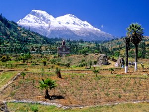
Located in the heart of the Cordillera Blanca a few hours’ drive from the tourist town of Huaraz, Huascaran is actually two mountains, Huascaran Sur and Huascaran Norte, linked by a 6000m col called La Garganta (which translates as The Throat). The lower peak, 6655m Huascaran Norte is the tenth highest mountain in South America, while 6768m Huascaran Sur is the fourth highest. More eccentrically last year scientists discovered that its summit is the point on the Earth’s surface with the lowest gravitational pull, which leads me to conclude two things: the mountain must be completely hollow underneath, and I will feel so light that I should be able to literally float to the top (I could be wrong about either of these things).
The standard route up Huascaran is from its western side, and involves a few days of hauling loads up a glacier to a high camp close to the Garganta, from where either summit can be reached in a single summit day. Huascaran Norte was first climbed in 1908 by Annie Smith Peck and the Swiss guides Gabriel Zumtaugwald and Rudolf Taugwalder. Peck was an interesting figure in the male dominated world of alpine mountaineering. A professional adventurer who made her living public speaking and writing in between travels in an era when very few men even considered it as a possible career, she became famous after climbing the Matterhorn in 1895, and earned notoriety by wearing a pair of trousers instead of a skirt.
There was something vaguely Keystone Kops about their ascent. All three decided to climb without crampons because it was cold and windy that day, and they had previously suffered from frostbitten feet where the metal of the crampon had pressed against their boots. Peck was far from being a skilled climber and relied heavily on the competence of her guides. On this climb she appeared to have one or two issues with one of them, Rudolf Taugwalder. Gabriel Zumtaugwald led the ascent, cutting steps with three or four hefts of his axe most of the way up while Taugwalder “held the rope” for Peck to follow behind. It’s unlikely this meant anything as sophisticated as a proper belay, as this would have meant the climb would have taken much longer than the seven hours it eventually did. Halfway up Taugwalder lost Peck’s mittens down the mountain when she demanded them out of his pack, and from then on she had to keep her hands warm by concealing them beneath a knee length woollen poncho she had brought along to wear on the summit. She had never intended to wear this garment to climb, and found it awkward to descend with because she couldn’t see where she was putting her feet, but it undoubtedly saved her from frostbite.

Because of the anticipated wind on the summit ridge they decided to stop just below and take altitude readings with a pressure hypsometer. This device measures the boiling point of a liquid, from which the barometric pressure and hence the altitude can be calculated. Unfortunately they weren’t able to get it alight, and while Peck and Zumtaugwald struggled with the matches, Taugwalder disappeared. He reappeared a few minutes later claiming to have nipped to the summit while the other two were trying to take readings. “As it was my expedition, I should like, as is customary, to be the first one to place my foot at the top,” Peck remarked haughtily in her book A Search for the Apex of America.
She was even more disappointed a short while later, when they reached the summit, looked across at Huascaran Sur and realised it was quite a bit higher. Their descent turned into something of an epic. The three or four swings of his axe Zumtaugwald had used to cut steps had been sufficient for ascent, but nothing like good enough for three tired climbers descending without crampons. The steps were toeholds at best, and Peck fell on her backside half a dozen times, saved only by the quick actions of Zumtaugwald who rammed his axe into the slope at the back of the rope and arrested their fall each time. Taugwalder somehow managed to lose both of his own mittens on the way down, and they reached their camp on the Garganta long after dark. Taugwalder’s frostbite was severe. He was treated by the doctor in the nearby town of Yungay when they returned to civilisation, and it was necessary to amputate most of his left hand, a finger of his right, and half of one foot.
The summit of Peru’s highest mountain, Huascaran Sur, was eventually reached for the first time in 1932 by a combined Austrian-German team which included Himalayan legend Erwin Schneider, who made epic attempts on Kangchenjunga and Nanga Parbat in the 1930s. Their ascent was much more straightforward than Annie Smith Peck’s. Seven people were in the summit party, five experienced German and Austrian mountaineers and two Peruvian porters, Néstor Montes and Faustino Rojo from Yungay. The porters weren’t supposed to go to the top but when the climbers looked back on their summit day and saw they were being followed they invited the two intrepid locals to join the summit party. “These were born mountain climbers,” one of the team later said about them.
Sadly half of Rudolf Taugwalder’s hand and foot were not to be the biggest loss on Huascaran over the years. On 31 May 1970 fifteen Czechoslovakian climbers, including the celebrated mountain photographer Vilém Heckel were wiped out in an avalanche, which was caused when an earthquake measuring 7.8 on the Richter scale struck Huascaran. The earthquake caused a massive slice of Huascaran Norte to collapse, later estimated at an almost unbelievable 1000m wide and 1.5km long. Ten million cubic metres of rock and ice plummeted 3km vertically and swept 15km horizontally at an average speed of at least 200 kmh, and by the time it reached the nearby settlements of Yungay and Ranrahirca, an estimated 60 million cubic metres of water, rock and mud had accumulated. 18,000 inhabitants were killed instantly by the avalanche debris as the towns were buried, and 66,000 in all died in the earthquake across the region. The US Geological Survey has an archive of poignant images from the event on the website of its Landslides Program.
There’s not much any of us can do about cataclysmic earthquakes, but I’m hoping to avoid major avalanches this time. Unfortunately, my recent record on big mountains isn’t good. Bad weather on Denali last year and Cerro San Lorenzo over Christmas prevented me from making a summit attempt on either mountain, and I’ve talked enough about my expedition to Lhotse this year, which was aborted for other reasons. The news from Huascaran isn’t good and the mountain appears to be in poor condition this year. I’ll be climbing with Altitude Junkies again, but their first expedition of the season ended in disappointment. Originally intending to climb Huascaran Sur they switched their objective to Huascaran Norte after hearing reliable reports of dangerous seracs and large crevasses blocking the route up Huascaran Sur. Bad weather then prevented them from making a summit attempt on Huascaran Norte after 12 inches of snow in two hours at their high camp made the summit slopes too much of an avalanche risk.
By the time you read this I will be in Huaraz bound for base camp, and should at least know which mountain I will be climbing. If there are large crevasses on Huascaran Sur then these are unlikely to be any safer a few weeks later. I can hope for better weather on Huascaran Norte than the first team had, but the news in Huaraz is not good with many teams abandoning Huascaran because of dangerous avalanche conditions and high crevasse risk. An alternative plan for us would to be to base ourselves in the Ishinca Valley and climb some other 6000m peaks of the Cordillera Blanca around there.
I’m keen to climb Huascaran, but sometimes you just have to go with the flow. I’m due another summit sooner or later, but will it be this time? You can follow my progress via the Junkies’ dispatches. I probably won’t be providing any updates myself until we return to Huaraz after the expedition.


Mark, you old dog. I wish that I knew you were doing this climb. We made an earnest attempt of Huascaran Sur back in 2009 with a precursor climb of Pisco. And I’ve been yearning to return to the area ever since. Here is a summary of our experience down there if you get some down time. http://www.southernhighlanders.com/Huascaran%20Climb.htm
Best of luck. You deserve a good expedition.
Sorry you didn’t make it to the top, but man, what an adventure. I know it’s been a few a years and I hope you’ve made it back since then.
I’m writing to you because I’m a young adult science fiction writer, and I’m writing a scene in my current book which takes place on the summit of Huascaran Sur.
I’ve been trying to get in contact with someone who has been to or knows about the summit and a fellow writer found your blog. I thought I would reach out and see if you were still active here and wouldn’t mind helping me out.
For my book, I need to know how large of an area the summit is. Google maps and the pictures I’ve seen make it appear like it’s a triangular section that is flat-ish, about 1000 by 2000 feet at the widest points. I don’t know how strongly the edges drop around the summit, but it does look like to the east its a sheer drop.
Any idea of a sense of scale will help me a lot. The characters won’t be climbing the mountain, but they will be having a fight vs the main villains here and depending on how much surface area I have to work with, and what the drops look like around it, is going to determine the strategy they use.
Thanks for hearing me out!