
I passed another milestone last week, when I completed draft four of my book about our journey to reach the summit of Chimborazo in Ecuador starting from sea level, travelling only by foot or bike. The fourth draft involved another round of edits based on feedback from a team of beta readers.
I have now sent the book to my editor Alex Roddie – just recently returned from an adventure of his own to walk the Cape Wrath Trail in winter. Alex will give the book a further polish with a round of line edits. My next job is to hire a designer to start working on the book cover.
The editing process has involved a lot of chopping. The following extract was reduced dramatically in previous edits, and I have now removed it entirely because it didn’t add anything to the plot. It’s an interesting read, however, about a couple of places in northern Ecuador that are rarely visited by tourists, but should be: the mountain Cotacachi and its picturesque crater lake.

The following morning we were on the road shortly after seven o’clock, with Javier driving us in his Toyota Land Cruiser. Our destination was Cuicocha, or the Guinea Pig Lake, a crater lake on the side of Cotacachi, another 4,944m mountain that we hoped to climb the day after.
Cotacachi was first climbed by Edward Whymper, Jean-Antoine Carrel and Louis Carrel in 1880. In his book Travels Amongst the Great Andes of the Equator, Whymper made no mention of Cuicocha, arguably the mountain’s most notable geographic feature. The lake was formed by a volcanic eruption 3,000 years ago, when its cone collapsed into a magma chamber. Two islands in the middle of the lake are the remains of volcanic cones that rose after the eruption.
Both Cotacachi the mountain and Cuicocha the lake have many legends associated with them. Maria Isabel Cotacachi is said to be the wife of Taita Imbabura (Imbabura being a 4,630m volcano which towers over the nearby town of Otavalo). Legend has it that Taita Imbabura was hunting deer one evening when he saw Cotacachi standing in the moonlight. He was stricken with love, and demonstrated it by erupting (a smutty metaphor if ever there was). When Cotacachi the mountain emerges in the morning clad in rivers of snow, the local people say that Imbabura has been visiting, and has decorated her hair with fancy ribbons. The nearby mountain Yanaurcu (4,535m) is believed to be their child.
The legends of Cuicocha are even odder. The lake is 3km in diameter and 200m deep, but it is said to be bottomless, reaching down into the centre of the Earth. In the local Quechua language, the name Cuicocha means quite literally ‘Guinea Pig Lake’. One story of how it came by this name was that locals would leave a guinea pig on one of its islands every time a child was born, and the island soon became overrun with rodents. Another myth involved a golden guinea pig. The first person to see it would become rich, while subsequent people would be turned into ducks. This explained why there are so many ducks on the lake. Call me cynical, but I tend to believe the more plausible explanation that the island is shaped like a guinea pig. As for the ducks, they probably just flew there.

The lake is believed to have healing properties. The Quechua people would bathe in its waters once a year to cleanse themselves of the spiritual grime that had accumulated over the previous year.
‘Do you believe there’s any truth in these stories?’ I asked Javier.
‘Well, my wife had a bit of an altitude headache when we came here last year. There was a priest conducting a ceremony in the room next door. The following morning my wife was fine.’
I wasn’t sure if that was a ‘yes’.
We stayed in a somewhat rudimentary lodge on the shores of the lake. Forested cliffs rose into clouds on the opposite side. We could see nothing of Cotacachi, but I assumed it must be up there somewhere. Two wooded islands nestled in the middle of the lake. They looked nothing like guinea pigs, but you can’t have everything.
Our walk around the crater took around five hours, on a well-maintained trail that occasionally dipped into a tangle of jungle, but mostly kept to the crater rim through terrain of long grass and low bushes. As we passed along the final stretch back to our lodge, the sun came out and the clouds began to disperse. It was tantalising. Although there was blue sky all around, the clouds never quite lifted off Cotacachi, and the summit remained hidden behind a fluffy halo.

Later that evening, Javier introduced us to the owner of our lodge, the Hotel Mirador. According to Javier, it was easy to lose the route on Cotacachi, and Ernesto Cevillano was the only person who knew it well. He had arranged for Ernesto to guide us. Ernesto was a cheerful grey-haired man about sixty years old. He didn’t speak English, but Javier chatted with him for a while and translated the important points.
‘He says the mountain changed after the 2016 earthquake, and the route is now different. There is more rockfall, but it is OK, he has found a way. We were talking about friends. He knows everyone. He is the go-to man for Cotacachi. He is the only one who knows the route, so everyone, all the main guides in Ecuador, contact Ernesto when they want to climb Cotacachi.’
After a good rest, we met at five o’clock the next morning and jumped in Javier’s Toyota Land Cruiser. This being Ecuador, we aimed to start the climb by driving as high up the mountain as we possibly could. We completed most of this in pitch blackness, with nothing to see but Javier’s headlights shining on the road. But after climbing on switchbacks for about forty-five minutes I suddenly caught a glimpse of the huge bulk of Imbabura over to our right. Behind its right shoulder was an unmistakeable snow dome rising above the plains.
‘I can see Cayambe,’ I cried, and everyone in the vehicle jerked awake and gazed out of the window (except for Javier, who was at the wheel and – I hoped – already quite attentive).

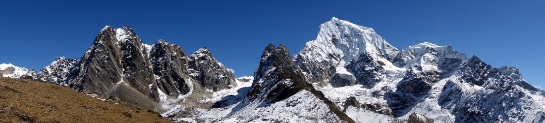
We passed through a maze of radio masts and parked up at 4,000m close to one end of a grassy ridge. It was six o’clock when we started walking through the long paja grass. The triangular summit of Cotacachi rose through the gloom ahead of us in a crumpled heap of grassy ridges, black-rock outcrops and icy couloirs. It was mostly clear but for a wisp of cloud hanging over the ridges beneath the summit.
Whymper’s description of the higher reaches of Cotacachi was quite vague. His guide led him up to 4,200m somewhere on the south side, where they decided the east face looked too precipitous. They kept to the west and pitched an unpleasant camp at 4,400m. After their second load carry, mists and snow whirled around them. The wind was so strong that they struggled to get their tent erect. For the next fourteen hours as the storm continued to rage, somebody had to lie awake supporting a corner of the tent that was in danger of collapse. By the morning six inches of snow had fallen, and they were unsure whether to proceed. But it was wet snow, and they didn’t think it posed a danger of avalanching (Whymper claimed he never saw any evidence of a snow avalanche during all the time he was in Ecuador).
Whymper gave no account of his route to the summit. All we know is that it took them just over three hours from their camp, and that the summit was ‘a pointed peak of lava, broken up by frost, extremely steep at the finish, and upon that account bearing little snow’.
In reality Cotacachi’s last few hundred metres appeared to be quite complex, giving credence to Javier’s belief that only Ernesto knew the route. Of more concern was that Taita Imbabura appeared to have paid a visit during the night, and Mama Cotacachi looked to be holding a lot of snow. This could prove a nuisance, because we weren’t equipped with crampons, although the streaks of ice could just be a trick of the dim, early morning light.

Ernesto tramped off quickly through the long grass, but Javier walked behind him to slow the pace. The temperature was comfortable, though it was a little windy. As we made our way up the ridge, the view opened out behind us. It was a new perspective on the mountains of Ecuador that we’d come to know so well. On the left were Imbabura and Cayambe, and on the right was the wide, black mass of Pichincha rising above Quito. Between these we could clearly make out the snowcaps of Antisana and Cotopaxi.
As we rose above the grassland, the route became intricate, threading a path around cliffs, but Ernesto knew the way. We ascended into the mist and it became increasingly cold and windy. We stopped to put on extra layers, harnesses and helmets. I managed to break my helmet in the course of tightening it, but ever the practical one, Edita fixed it for me after I’d faffed around for several minutes trying to repair it myself.
After weaving around crumpled rocky outcrops covered in moss, it eventually became clear that we were following a ridge. To the right it was extremely windy, but when we dropped below the left side of the ridge it was nice and sheltered, and really quite pleasant walking.
But the mist was becoming a problem, as were the multitude of cairns that had been erected, some of which led up dead ends. At one point Ernesto took us on a scramble to the right, only to find it arrived at a horrendous traverse across a deadly scree chute. We spent about fifteen minutes looking for a safer option, but it was only after we descended again that Ernesto found the real trail further to the left. In the mist he was fooled by an obvious cairn marking our dead end. On the descent we dismantled it.

The route became increasingly icy, and although the scrambling was easy, the combination of wind, mist and ice meant that our climb was starting to take on an epic feel. We traversed around to the right of a giant rock buttress, and the route led up a steep rock gully. Edita’s altimeter was reading 4,700m, and Ernesto estimated we were about an hour from the top. But Javier felt the verglas (thin layer of ice) on the rocks made it too dangerous to proceed. Beneath us the mountain plummeted into the mist in a steep ramp of red earth and icy boulders.
‘I think we might be able to get up safely, but it’s going to be very dangerous coming down again. One slip on the ice and you could be gone,’ Javier said.
He seemed apologetic. Perhaps he thought we would be unhappy, but for me it didn’t matter. I trusted his judgement, and Cotacachi wasn’t our main objective.
The descent was even more intricate than I remembered and the weather didn’t get any better. To compound things, there was a lot of loose rock. I knocked a stone the size of a baseball out of the earth, and watched in horror as it bounced down the slope in the direction of Javier.

‘Rock, rock, rock, rock,’ I cried.
Luckily Javier realised I wasn’t doing my impression of Freddie Mercury trying to get the audience excited. He turned quickly, saw my missile and ducked out of the way.
We made it down without mishap and emerged from the cloud. As we passed through the grasslands back to our vehicle, Ernesto revealed a knowledge of plants that would flatter an apothecary.
‘Menta de pimienta,’ he said, picking a herb and inviting us to rub it in our hands. It gave off a strong smell of peppermint.
The tall paja grass was rich with an abundance of hidden plants and flowers. He pointed out ananás (pineapple), white and yellow margarita (daisies), and yellow mountain arnica. And then of course there was the ubiquitous orange flame of the chuquiragua, which Ernesto made us repeat over and over until we pronounced it correctly.
We arrived back at the vehicle at midday and drove back to the Hotel Mirador, where Ernesto gave us some of his photographs, including one of a cloud-free summit pyramid of Cotacachi. We could recognise none of it, nor make head or tail of the route we took up.


Love this story. I can’t believe you don’t want to include it in your book. Glad you let us read it. I’ve been there and done that. Congratulations!
I really liked that story, keep up the great work Mark!